

By DONALD GILLIGAN
Special guest post
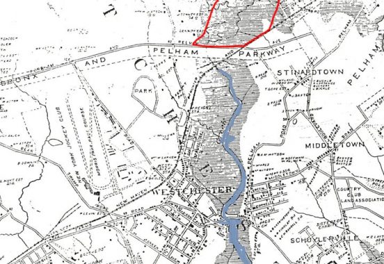
In the beginning there was salt marsh as the hatched area in the accompanying map (Ca. 1890) indicates. The area outlined in red is where the development of Pelham Gardens began. The blue stream is the headwaters of Westchester Creek that once reached almost to Pelham Parkway. It has been filled in and built over along with its marginal salt marsh for many years now. For most of the 20th century that was the fate of most of the wetlands in NYC and the Pelham Gardens area was no exception.
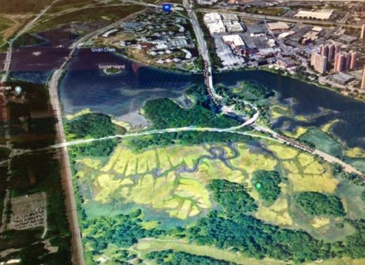
A salt marsh is a coastal feature consisting of a low-lying area of unconsolidated sediment just barely above high tide and covered with Spartina, a salt tolerant grass. The pale green area in the foreground is a remnant in Pelham Bay Park of a salt marsh that once extended from the Hutchinson River to the headwaters of Westchester Creek and beyond. It included the area where the original Pelham Gardens development was built. Take a look at the aerial photo and it should be apparent that a salt marsh is not a very hospitable place to build housing.
Take a stroll across a salt marsh and experience the spongy feel of the turf and you will know why construction awaits a landfill operation before development begins. Sometimes it takes quite a few years for the overburden to compact the underlying sediments and create a suitable condition for construction to begin.

The Pelham Gardens landfill began in the early years of the 20th century as the result of NYC’s need for a new reservoir. In 1895 the city acquired the Jerome Park Racetrack property, an elegant venue for the nabobs of the NYC area. It looked like something right out of the movie set for “My Fair Lady.” The racetrack operation moved to the East Bronx to operate as the Morris Park racetrack. In 1904 the racing operation removed to Long Island where it continued as Belmont Park but it left behind a name that defines an area of the Bronx to this day.

To convert a racetrack into a reservoir you need to do a lot of digging. The winning bid for the reservoir excavation was made by John B. McDonald, a contractor with experience doing excavation work. He made his reputation building a tunnel beneath downtown Baltimore to bring the B&O railroad to Baltimore Harbor. He is credited with building the first NYC subway from City Hall to 145th street. The actual work was done by a group of sub-contractors that McDonald hired and assigned to sections of the line. His oversight ensured that they finished the job on time. During the same time period he was executing the contract to build the Jerome Park Reservoir. He was a man who got things done. One look at his photo and you will think that this is a man not to be trifled with.
The reservoir job involved the removal of over 4 million cubic yards of material. Digging it out is only half the job. You can’t just shove it over to the next door neighbor’s property. You need to dispose of it in a way that avoids lawsuits. McDonald’s solution was to do a landfill on the Meadows as the marshland was called at that time. He had the foresight to purchase 350 acres of the marshland property to receive the excavated material. You can be assured that when he disposed of the “improved” property he made a profit.
The following is an excerpt from the July 1901 issue of Scientific American Magazine which describes the disposition of the excavated material.
Scientific American
July, 1901
Disposition of material excavated for construction of Jerome Park Reservoir
Of 4,000,000 cubic yards which have been taken out to date, about 20 per cent has been used in filling near the Kingsbridge road and in Bronx Park. For the disposal of the other 80 per cent a single line of track has been laid for a distance of 4 miles, through Bedford Park, across the Harlem Railroad tracks, through Bronx Park and down Pelham Bay Parkway to the stretch of tide lands formed by the head waters of Westchester Creek and Westchester Bay, which is known as the Meadows. Commencing where the Parkway leaves the edge of the sloping grounds, this enormous mass of 3,200,000 cubic yards of sand, gravel. hardpan and solid rock has been dumped out upon the tide lands, until now a large proportion of a square mile has been filled in to a depth of 18 to 20 feet.
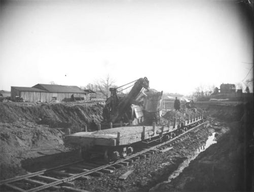
The article goes on to describe with illustrative photos the method of moving the material to the dumpsite. The material was loaded onto flatcars by a steam shovel.
When the cars where loaded they were hauled to the dumpsite by a locomotive.

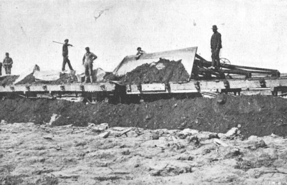
All photos from New-York Historical Society
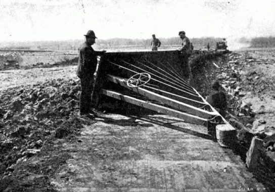
Upon arrival a plow board was fitted to a flatcar at the end of the train and drawn by a winch and cables to scrape the material off the flatcar and all the others on the train. When all the cars were cleared, the train went back for another load.
Don Gilligan is not yet a lifelong Bronxite. Retired computer programmer, systems analyst and programming services entrepreneur. Longtime FNY fan. Member of Bronx County Historical Society and the East Bronx History Forum.
As always, “comment…as you see fit.” I earn a small payment when you click on any ad on the site.
6/1/21
1 comment
It’s remarkable how methods like this one with the tilting track, while very innovative at the time, albeit simple, have been put by the wayside for much more complicated methods. There is something to be learned in simplicity.