

A lot of Queens posts this week…what can I say, that’s where I’ve been lately. Don’t worry, there’s plenty of material “in the can” for the four other boroughs which will be presented for inspection soon. I just noticed that on both Google Maps and Open Street Map, there’s an alley called Wells Place that I had never heard about before, or seen on any other maps.
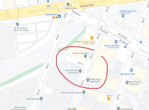
Here’s an Open Street Map excerpt. We can see the alley Wells Place on 55th Street in Woodside, just south of Broadway and north of 37th Avenue…
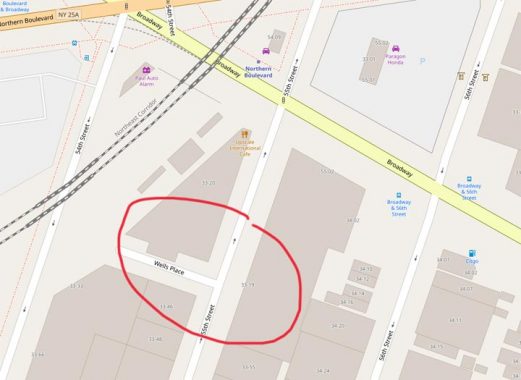
And here it is, too, on Google Maps, which has stepped up its game lately with house numbering and true representation of lanes at complicated intersections. Wells Place is shown there, too.
As you can see on the title photo, Wells Place looks like a standard issue private driveway, with a gate and a fence protected by barbed wire. On Google Maps, it’s between Liberty Auto Glass and Business Class Limousines.
So what’s going on?
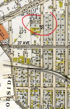
Well, let’s consult a 1909 Bromley atlas of the area. While much of Woodside was still empty territory, this particular region had already had streets laid out, with its own set of numbered streets. 55th Street was then called 2nd Street, Northern Boulevard was called Jackson Avenue, and Broadway had not yet been extended through yet and wouldn’t be till the IND subway was built decades later.
And… there’s Wells Place. No doubt it was a real street then, and it wouldn’t become a driveway until decaces in the future.
No doubt, mapmakers in the present (and how I would dearly love to be on the Openstreetmap or Google Maps reserch staffs) consult old maps, and this just proves that they sometimes go a long way back in their research.
But calling an active driveway a street that stopped being a street decades ago is a bit of a stretch, no?
As always, “comment…as you see fit.” I earn a small payment when you click on any ad on the site.
6/17/21
14 comments
I’m digging your research on Olde New Yawk!
So is this private property now? If it’s an actual public street isn’t that violating some kind of something to fence it off?
Wouldn’t be surprised if it was just made “private” property by the adjoining property owners, figuring who would know about such a remote location.
The city’s official street map (streets.planning.nyc.gov) does not have this Wells Place. Search for 33-19 55 Street Queens to zero in quickly. (There is a Wells Place in Brooklyn!)
MS Bing maps calls it Elks Place.
I thought it was quite a big process to get a street turned into private property, so it seems like there would be a record of the change. There were a few in Astoria including one between 20th and 19th ave, around 47th? which was taken over by a liquor distributor.
I suspect that a land survey would show that someone fenced off a public road.
Yeah,whats up with that?All you have to do is put up a couple of fences and a gate and
a public street is now yours for the taking?And nobody says anything?And I’m seeing
that attitude in other parts of the country too
What sometimes can occur in Australia, and particularly in Melbourne, city of laneways, is that residents or neighbouring owners simply fence of a public right of way (laneway) and hope no one notices until decades later when they claim “adverse possession” under a relic of English Law.
Something similar exists on 54th Rd between 43rd and 44th St in Maspeth. The road is on maps, but has been taken over and built on. The east end is used as a storage yard, and the west end has a building on it.
I always thought that if an alley becomes a gated driveway it becomes demapped, but I guess that’s not always the case, though there such a thing as gated alleys that existed in NYC and other places around the country and the world as well.
It’s private property (not a street mapped by the city) in the NYC official map but as a parking lot labeled Elks Place for some reason. The deeds for property in ACRIS show Wells Place as one of the bounds from “Map of Hitchcocks Plan for Homes at Woodside, Queens County, Long Island” so a property owner to the north bought the land from the city at some point. Learned this too: When plotting his land Hitchcock renamed the land Woodside in place of Suicide’s Paradise (lots of miasma from the swamps)
There are lots of streets like this. If an employee of an adjacent business is ever injured due to a pothole or winter ice, the businesses’ lawyers will insist it’s a public street after all (despite the fence), leaving the city’s taxpayers to pick up the tab for the lawsuit.
We see a No Parking notice painted on the driveway. This clearly indicates private property.