

WHEN most New Yorkers think of Murray Hill, they likely think of the area on the east side of Manhattan, just south of the United Nations between 34th and 42nd Street and east of Madison Avenue…and they well might, since its tree-lined streets harbor beautiful brownstones, high rise buildings and townhouses. It is home to prominent professional, political and social clubs, as well as the recently renovated Morgan Library – a must visit for both NYers and visitors alike.
Murray Hill has never been a small town on its own, as so many Queens neighborhoods like Long Island City, Jamaica, Flushing or Newtown (today’s Elmhurst) had been. It’s always been considered to be the eastern end of Flushing, and been a planned development carved out of Flushing’s vast acreage of plant nurseries in the late 1800s. In 1889 developer Frederick Dunton, a shareholder in the Long Island Rail Road, purchased large parts of the Robert Bowne Parsons estate, divided it into lots that quickly were snapped up. A railroad stop, school and firehouse were built (their descendants remain in place today, though the original school is now a modern structure (PS 22, the Thomas Jefferson School, on Sanford Avenue east of Murray Street). Murray Hill did develop a separate suburban identity from Flushing that it retains today; though multistory apartment builings were constructed near the Murray Hill RR station, they had a panache that today’s quickly proliferating multifamily buildings lack.
Before the neighborhood was developed by Dunton, the Murray family also held a lot of land in the area, and of course partnered in some of Flushing’s former plant nurseries, and also owned the Kingsland mansion on 37th Avenue that is now the home of the Queens Historical Society. Murray Street and Murray Lane are named for the family.
Murray Street is a lengthy route in Murray Hill, running continuously south from 17th Avenue to where 45th Avenue meets 156th Street. For most of its journey it slots in between 150th and 154th Streets.
There’s a second street named Murray in the area, Murray Lane, which is narrower and issues north from Murray Street at 35th Avenue and continues north as far as 25th Drive. This is a pleasant neighborhood with plots holding mostly one family homes with lawns, and there’s a considerable tree canopy on the side streets. Murray Lane for much of its run is typical for the area, with sidewalks on both sides of the street. Midway between 32nd and Bayside Avenues, though, the sidewalks drop away and Murray Lane appears the way you see it above, looking considerably more suburban or even rural. The route remains mostly sidewalk-free and quite narrow till you get to its northern end, with relatively few properties facing it. This begs the question, why is it even there and how did it survive at all? The map record gives you a fairly good idea why.
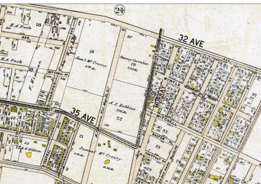
Murray Lane is considerably older than Murray Street though when this map was produced in 1909 both were already in existence between what became 32nd and 35th Avenues. Note the heavier lines on 35th Avenue and Murray Lane, this was a streetcar line that ran on the two streets.
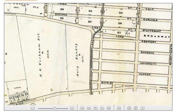
North of Bayside Avenue in 1909 Murray Lane ran through open country though some streets were laid out east of it. These may have been “paper streets” though. From here the streetcar line ran along several area streets in Whitestone until it reached the East River waterfront at what is now the Waterpointe development. I’m not sure when this trolley line went out of business, but its right of way, Murray Lane, has survived the decades since.
As always, “comment…as you see fit.” I earn a small payment when you click on any ad on the site.
10/2/21
2 comments
I was confused until I worked out that there are two areas called “Murray Hill” one in Manhattan and one in Queens.
In your research have you come across a “Murray Hill Mansion”? It would have been on the south side of Northern Boulevard (or maybe at Roosevelt Ave) and between around 157 St. and 156 St. It was diagonally across from St. Andrew Avellino Church. I grew up in the 1950s and 1960s on 161 St. between Station Rd. and Sanford Ave. In the 1950s I remember a big empty lot of land with ruins and foundation of an old building. In the 1950s we called it the “Murray Hill Mansion”. I believe a shopping plaza was built on this vacant land in around the late 1950s/1960s. I enjoy “Forgotten New York” and your thoughtful meanderings through Flushing. If there wasn’t a “Murray Hill Mansion” do you know what building was there?