

WHEN you are driving or biking east on Delancey Street under the Williamsburg Bridge approach, and suddenly decided you’re going the wrong way and want to head west instead, there are several options to get to the north, westbound section of Delancey. Willet Street? Nope, one way south, if you’re in a car. If you forge ahead, you have an opportunity, this one-block street that heads north and will get you under the Willie.
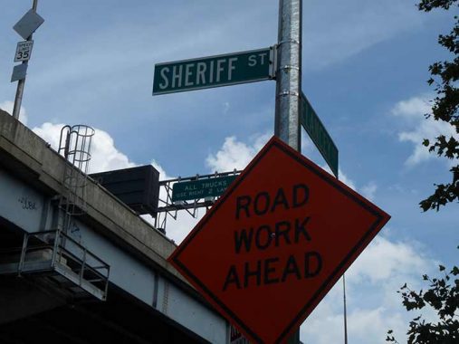
It’s not just a passageway, though, it’s actually a named street, Sheriff Street. It’s one of a group of north-south streets in the Lower East Side east of Pitt Street that have been largely out of existence since the 1950s that include Willet, Sheriff, Columbia, Cannon, Lewis, Goerck (later renamed Baruch Place) and Mangin. Bits and pieces of many of them are still in place, but the shortest piece belongs to Sheriff, today just a one-way passage beneath the bridge.
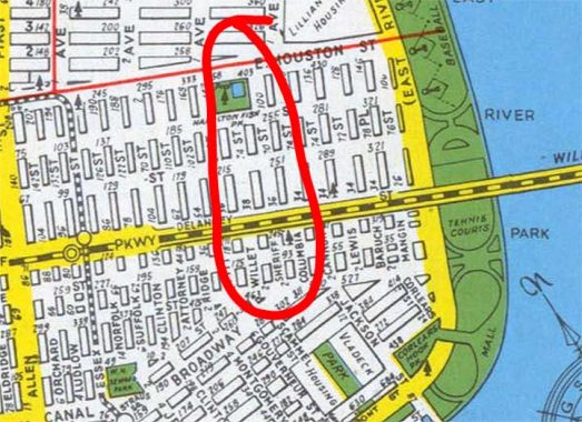
Here’s a map of the Lower East Side from 1949 showing this ill-fated collection of north-south streets.
The Gompers and Baruch Houses were constructed between 1956 and 1964, eliminating most of these streets and all the old buildings from the late 18th and early 19th Centuries. Most were built as cold water flats and only had heating and hot water added later. Columbia Street was retained as a north-south route, and bits and pieces of the former streets are still to be found here and there. All that remains of Sheriff is that small piece under the bridge…. or is that all that remains? We’ll see…
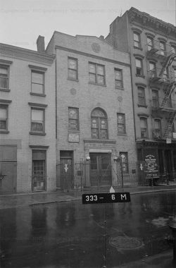
What did Sheriff Street look like? We have a good idea thanks to the Municipal Archives and its collection of 1940 tax photos. Here is a synagogue at #58 Sheriff.
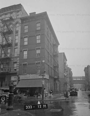
#70 Sheriff at Rivington. The Williamsburg Bridge approach can be seen in the background: the only thing presently remaining in the area.
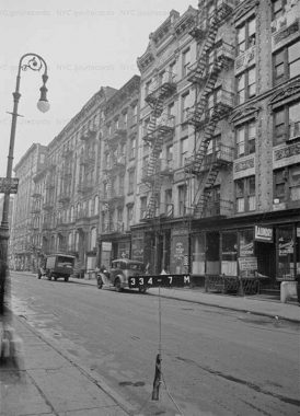
This scene at #86 Sheriff is typical of the streetscape of the early 20th Century.
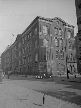
I’m not sure which school this was at #116-126 Sheriff at Stanton Street but it was impressive.
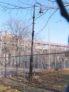
I hinted that there may be other vestiges of Sheriff Street remaining. This ancient Type 6 Bishop Crook still stands, rusted but unbowed, at the former corner of Broome, which runs through here as a sidewalk in the Hillman Houses at the edge of the Luther Gulick Playground.
As always, “comment…as you see fit.” I earn a small payment when you click on any ad on the site.
10/5/21
19 comments
Cool beans! It’s like a native New Yawka’s secret!
Google maps shows Sheriff street between Houston and Stanton but in reality it’s a driveway by the NEST +M School.
Wyatt Earp lived there before heading out West.
The NYC Birth Index listing for my grandfather (b. 1891) gives the address at 52 Sheriff St.
Bu for what or whom is Sheriif named for?The Sheriff of Nottingham?
Clearly the old map doesn’t show it going up this far, but it sort of aligns with the path of Szold Pl, at East 10 between C and D. I wonder if, longer ago, that was a continuous route.
I’ve looked at maps from 1879 forward and none show Sheriff – or any other roadway along the same line – extending above East 2nd Street. Szold Place appears to be the old Dry Dock Street. If you extended Dry Dock/Szold down to East 2nd it would sort of be equidistant between Willett and Sheriff.
Lewis extended further north than its brother streets.
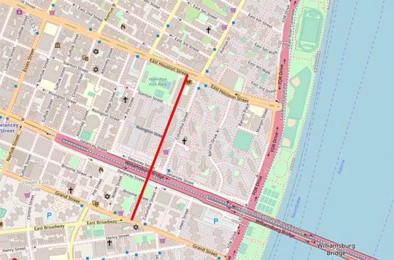
I worked as a site supervisor for the East River Co-op (formerly ILGWU Houses), Hillman Houses and Seward Park Housing Coops and I used to explore the former routes of the long gone streets. Sheriff Street ran north for five blocks, starting on the north side of Grand Street directly across from where East Broadway starts, and terminating between E.2nd and E.Houston Streets. You can compare the northern terminus as seen in the street atlas plate at the link I provided and Google Maps to see how that area was reconstructed in later years.
https://digitalcollections.nypl.org/items/a1ed0d43-d541-e912-e040-e00a180645ad
The old atlases show the school at Stanton & Sheriff as Grammar/Public School 22 which was composed of both of the buildings in the linked photo, the section on the right being the earlier section.
Some may find this item of interest — or at least the nerds such as myself — which documents from whose land and at what times various sections of the school — the rightmost of the 3 on the page — were constructed: Grammar/Public School 22 Real Estate Data
Our word “sheriff” comes from the Dutch “Schout.” I don’t know if there’s a connection to Dutch New Amsterdam.
I could be mistaken, but I believe the word “sheriff” is a corruption of the old English “shire reeve”, a local official.
I stand corrected.
The school off Stanton Street was P.S. 122, replaced by JHS 22.
I was born at 95 sheriff st lol lol
I have an old document that says there was a wedding reception at the Central Palace Hall at 66-68 Sheriff Street. Anyone have any info or thoughts on that?
1902
I was born and lived at 62 Sheriff St. in the early 1950’s. I recall the synagogue in the above photo- Block 333, Lot 6 clearly – it was an active house of worship then. I don’t recall a Central Palace Hall at 66-68. That may be the building that became a warehouse and delivery depot for the seltzer company that was there in the 50’s.
My maternal grandmother and her 11 siblings lived on Sheriff Street along with her youngest brother who was affiliated with the mobster Dutch Schultz. Their building was just next door to the poster from 7-3-22 who lived at #62 Sheriff Street. Of further note, The infamous Rosenbergs who purportedly sold nuclear secrets to the Russians were also living in that building.