

YOU can observe a lot just by looking, as Yogi Berra used to say. For example, here’s a handsome brick building on Washington and st. Mark’s Avenues at the edge of Crown Heights that goes back quite a few decades and fortunately, looks pretty much the same as it always did. What’s unusual about it?
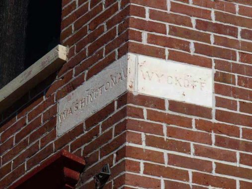
It has a pair of chiseled street signs. This used to be the favored method of street signage; signs mounted on lampposts or phone poles didn’t come until the early 20th Century, when lampposts got large enough to pull that duty.
But instead of St. Mark’s Avenue it simply says “Wyckoff.” That’s a clue that at one time, St. Mark’s Avenue was called Wyckoff Street. There happens to be a Wyckoff Street in Brooklyn, named for Dutch immigrants in the colonial era, but it’s way west in the Cobble Hill-Gowanus areas. At some point, it was renamed in pieces. Between 3rd and 5th Avenues, it was renamed St. Mark’s Place and from 3rd Avenue all the way to its east end at East New York Avenue at the Howard Houses in Brownsville, it became St. Mark’s Avenue.
In fact if you take a look at this map from 1866, not only Wyckoff but Warren, Baltic, Butler, Douglass, DeGraw and Sackett Streets were also much longer, crossing Bedford-Stuyvesant in their miles-long lengths. But between 1874 and 1881, their names were all changed, with Sackett east of Washington Avenue swallowed up by Eastern Parkway , which was built in the early 1870s.
What happened? Murder happened. On March 20, 1873, Lizzie Lloyd King, a.k.a. Kate Stoddard, shot dead her boyfriend, Charles Goodrich, who wished to break off the relationship, at 731 Degraw, just west of 5th Avenue (the address has been renumbered since) . She fled with several of Goodrich’s possessions before returning the next day to clean and dress the corpse before going to her job at a hat factory. Just another day in Park Slope. After a three-month investigation, aided by Stoddard’s friend Mary Handley, the murderer was apprehended and sentenced to the State Lunatic Asylum in Auburn, NY; the building still stands. A 2013 play by Claudia Barnett examined the murder in the context of the works of Emily Dickinson.
Real estate values in the area dropped as a result of the murder. As a result, the decision was made to change Degraw Street’s name, and the other parallel streets in the area followed suit between 1874 and 1881. Warren and Baltic became “Prospect” and “Park,” a bit clever, for nearby Prospect Park; Butler, “Sterling Place’ for William Alexander, Lord Stirling, who led the patriots in the Revolutionary battle at the Old Stone House; Douglass (the name isn’t connected with abolitionist and orator Frederick Douglass) became St. John’s Place, for St. John’s Episcopal Church, built in 1870 on Douglass in 1870; Degraw became Lincoln Place, for Abraham Lincoln; and Sackett became Berkeley Place, for Irish philosopher and Anglican minster George Berkeley (1685-1753), for whom Berkeley, CA is also named.
Meanwhile, Wyckoff Street becomes St. Marks Place at 3rd Avenue and then, St. Mark’s Avenue at 5th Avenue. The name puzzles me, since the nearest St. Mark’s Church is the Episcopal church at Brooklyn Avenue and Union Street in Crown Heights.
Much more on this can be found on FNY’s Douglass Street page.
Meanwhile, this ancient carven sign reminds us of a time before a murder changed Brooklyn’s street map.
As always, “comment…as you see fit.” I earn a small payment when you click on any ad on the site.
11/22/21
6 comments
That map from 1866 is quite interesting. It shows a dense street grid in the City of Brooklyn that becomes very sparse across the line in the Town of Flatbush. Was it really that way in 1866, or was the author of the map interested in highlighting the City of Brooklyn?
As always, mapmakers show ‘paper streets’
I didnt know “carven” was a word.
All words were made up at some point.
Several of these streets once took a nearly 90-degree turn at East New York Avenue and extended into western Brownsville: Baltic, Degraw, Douglass and Union Streets. These names persisted in Brownsville after the Crown Heights sections were renamed because Brownsville was still part of New Lots Township, so Brooklyn’s renaming of streets would not be in effect there. In 1887 (after the annexation of New Lots to Brooklyn) the Brownsville section of Baltic was renamed Bristol Street. Degraw became Barrett Street for a while before becoming Legion Street circa 1937. Douglass Street hung on in Brownsville, miles away from Cobble Hill, before becoming Strauss Street circa 1937. Of these streets, only Union Street remains unchanged between East New York Avenue and East 98th Street.
On the eastern edge of the 1866 map there’s shown today’s Kingston Avenue, but under the name Hudson. As that’s part of the sequence of streets named for cities in New York State, Kingston is logical enough, but why the original name?