JAMAICA is one of Queens’ three oldest neighborhoods, along with Newtown and Flushing, and it’s no surprise that those three neighborhoods have the lion’s share of colonial-era buildings and locations. In 1655, Dutch settlers purchased acreage from the Canarsee Indians in the general neighborhood of the now-vanished Beaver Pond and set up a small community they named Rustdorp (“peaceful village”). By 1664 the Dutch had surrendered their holdings in New Netherland to the British, who renamed Rustdorp as Jamaica, an English transliteration of “Jameco,” the Indian tribe that lived near what is now called Jamaica Bay. Jamaica originally included all lands south of the present Grand Central Parkway (which explains why Jamaica is so far away from Jamaica Bay).
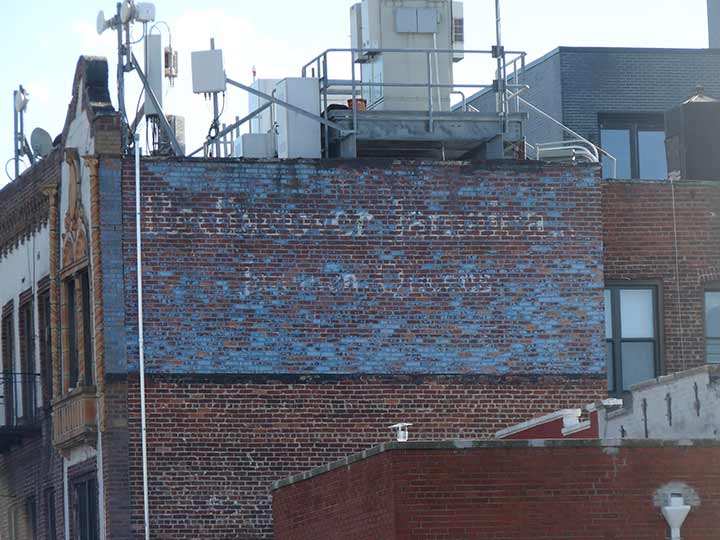
This much-faded painted ad “Rediscover Jamaica” can be found on an apartment building on 150th Street south of Hillside Avenue, one of Jamaica’s two main east-west roads that aren’t parkways or expressways, the other being Jamaica Avenue itself. Once blue with white lettering, it’s part of a long-ago neighborhood revitalization scheme. Even with the fade, I can tell that the font is Goudy Bold.
As always, “comment…as you see fit.” I earn a small payment when you click on any ad on the site.
2/8/22


8 comments
Jamaica was originally a town in Queens County prior to the NYC consolidation in 1898, much like North Hempstead and Hempstead are towns in present day Nassau County. As you correctly noted, the Town of Jamaica encompassed roughly the entire southern half of today’s Queens borough, except for the Rockaway Peninsula. Any Queens community with a 114 zip code prefix was originally the Town of Jamaica, and is part of the Jamaica Post Office. That’s because the US Postal Service continues to have four separate main post offices in today’s Queens, a legacy of the pre-1898 Queens County town boundaries. The other three are Flushing (113xx), Far Rockaway (116xx), and Long Island City (111xx).
Jamaica has always been a commercial crossroads because of its location on major transportation routes – Jamaica Avenue, the LIRR, and NYC subways. Jamaica Avenue’s shopping district goes back even to before the 1917 elevated train extension to 168th Street (since removed and re-routed east of 121st Street, and today’s J train route). The classic 1939 WPA New York City Guide noted that Jamaica Avenue was a comprehensive suburban shopping district, keeping in mind that Queens was considered to be a suburb before World War II.
The development of newer Queens shopping districts, such as Fresh Meadows and along Queens Boulevard in Rego Park-Forest Hills, plus shopping malls in Nassau County, hurt Jamaica’s commercial base after 1950, leading to many attempts to revive the area as the “Rediscover Jamaica” sign is obviously trying to do. Green Acres Mall in Valley Stream today serves many Eastern Queens residents who in years past would do their shopping in Jamaica.
Queens also went by the ward system: 1st ward- city of LIC, 2nd ward, Town of Newtown, 3rd ward, Town of Flushing, 4th ward, Town of Jamaica, 5th Ward, Rockaway Peninsula
Downtown Jamaica’s shopping district suffered greatly from reduced transit access during the 11-year gap between the closing of the Jamaica Avenue El and the opening of the Archer Avenue subway. Of course the merchants who saw their revenues fall, some of whom ended up failing, had been the most strident campaigners for getting rid of the noisy and unsightly old el, even though they knew Archer Avenue would be years off. Go figure.
I’d love to rediscover Jamaica. Book me on aflight to Kingston toot sweet!
It isn’t often clarified enough that Hollis Hills, Bellerose (Queens), Floral Park (Queens), New Hyde Park (Queens) and Glen Oaks, which are all south of the Grand Central Parkway, were formerly a part of the Town of Flushing and not Jamaica. The borderline of the two towns roughly followed Braddock Avenue (formerly part of a much lengthier Rocky Hill Road) after leaving the area of the Grand Central Parkway to Jericho Turnpike, and an imaginary line southward to the current Nassau County line.
Yes, and maps will show that section of Queens is shown ward wise as part of the 3rd ward
I think there was once a Chevrolet dealership in Jamaica called Jameco.
A rectangular section of the same blue paint can be seen above the side of a Dominican salon on 161st St off of Hillside Avenue! There is some dripped white paint above it, so I wonder if there was a similar ad there too and the building owner crudely covered it up. Google Maps from 2012 shows the same thing so it could’ve occurred earlier…