
As I am writing this in early August 2022 we’re in the midst of a long slog of hot, humid weather which is increasingly the trend in NYC as cool Canadian air is increasingly absent the last few summers; before the 2000s you could count on some cool invasions mixed in with the hot humid days. Those days seem to be over with. Thus, I was a bit nostalgic for clear, crisp weather (which will return, though it seems to come back later each year) and I remembered a walk I took on April 30 of this year when it was in the 40s in the morning and around 68 in the afternoon. Here are some of the highlights of that particular walk. I have posted from Gravesend often…it’s a favorite part of town for me… and I’ll repeat some info from previous pages here (that’s easy to do when FNY has been around for nearly a quarter century).
Photos in batch: 96
Photos taken: 4/30/2022
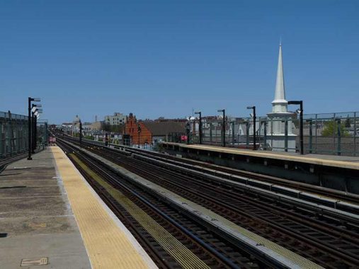
From the west end of the 25th Avenue on the West End elevated (D train), the steeple at right belongs to a branch of the Church of Jesus Christ of Latter-Day Saints, known popularly as the Mormon Church, at #2455 86th. Meanwhile, toward the center we see Engine 253, a firehouse east of 24th Avenue. The Parfitt Brothers, the architects of four firehouses in Brooklyn during 1895-96, designed Engine Company 253, a designated New York City Landmark. The upper stories display multiple step gables, also known as corbie or crow gables, popular in northern Europe from the 14th to the 17th century.
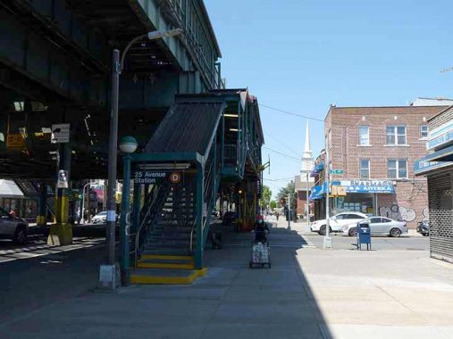
Though short davit lampposts with LED lamp fixtures have taken over underneath the el on 86th Street, here we see a leftover octagonal pole illuminating the staircase up to the 25th Avenue station. It’s joined by an indicator lamp with a green “cap” that shows that the entrance is open 24/7.
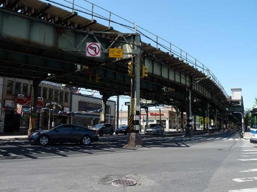
The West End elevated is, of course best known for its role in the 1972 film The French Connection, when detective Popeye Doyle commandeers a vehicle and pursues a drug henchman who has forced a subway motorman to run a train nonstop. Director William Friedkin and movie producers did not secure permission for the stunt driver in his route down 86th Street and New Utrecht Avenue, and many of the near-misses you see in the movie were, in fact, real near-misses.
People were out and about as the weather was warming. L&B Spumoni Gardens on 86th Street between West 10th and 11th has been dispensing pizza, Italian food and spumoni desserts since the 1930s. More conventional slices are available, but L&B is renowned for its squares, similar to Detroit-style pizza, with thick crust and tomato sauce on top of the cheese. However it’s not as heavy as Detroit pizza (which is actually sold in NYC at Lions, Tigers and Squares, at 8th Avenue and West 23d Street).
The restaurant as currently configured was constructed in the 1950s. At first, the Gardens sold just desserts and ice cream (which they still do), but later became famed for its Sicilian-style thick crust pizza. The Barbati family continues to operate the venue. Like Many Italian restaurants, there’s a sit-down dining room and a pizzeria on the side serving slices or in the Garden’s case, squares.
I received a lot of flack in the past for featuring L&B in Forgotten NY, because people enjoy nitpicking about what is “forgotten” and what isn’t. Look, FNY details infrastructure and can also be seen as a neighborhood guide, and I mention places I like, case closed.
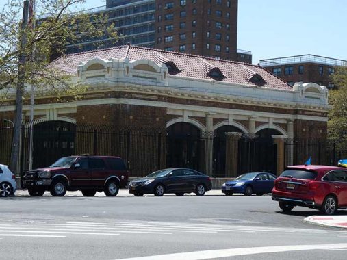
Standing on Avenue V just west of 86th Street in Gravesend is one of NYC’s very few decorative structures associated with its sewers, all due respects for the gigantic Digester Eggs of Greenpoint. It resembles one of the Beaux-Arts subway entrance buildings designed by Heins and LaFarge back when the subway originally opened in the first decade of the 20th Century. The Avenue V Pumping Station was constructed between 1911 and 1916, at the tail end of the Beaux Arts era, designed by architect Albert A. Martin and was eligible for NYC Landmarks designation in 1998. It was given a $210M dollar restoration in 2015 that repointed the brickwork and touched up its terra cotta trim and Spanish tiled roof.
More, including an interior photo, on this FNY page.
Speaking of subway entrances, here’s one of a plethora of station houses constructed by the BMT in the 1910s, most of them on the Sea Beach Line, or the N train. Nobody seems to write about these much but I really love them. They were constructed along the lines of the utilitarian “Arts and Crafts” genre and still have attractive tilework and mosaics. Some (not this one) still have original lighting sconces. The entire Sea Beach line was reconstructed in the 2010s and the station houses were given new leases on life.
Embryonic stoplights at Avenue W and 86th Street. Frankly, I’m rather surprised that a mere stop sign has been previously deemed sufficient at this relatively busy intersection. Google Street View indicates the new stoplights were up and running shortly after April 2022.
This triangle honors Private First Class Armond Cutinella, who died in the Battle of the Bulge (December 16, 1944 – January 25, 1945), a conclusive battle that took place toward the end of World War II. A local hero within his Gravesend community, Cutinella’s family and friends advocated for the creation of this green space in his honor. [NYC Parks]
While Parks calls this triangle-shaped space “Cutinella Triangle,” the Department of Transportation has been steadfast in its “Cutinella Square” signage for decades. Who should we defer to? Comments, as always, are open.
Bear with me if I’ve mentioned it before, but walking north on West 5th Street just north of Avenue V, if you’re looking for it you’ll find what looks like a private driveway on either side of the street. And, that’s what it is today, in effect. However, before 2003 or so it was actually a public street called Lake Place. The dead giveaway is a street sign for West 5th on the telephone pole as well as city-installed street lighting. The part of the road east of the BMT Subway at West 7th was privatizeda couple of decades ago, while west of the subway, it remains a public thoroughfare. It’s actually one of the oldest roads in Gravesend and I discussed it in FNY as early as 1999.
Gravesend, in the colonial era, was a British outpost in an era of complete Dutch domination. Because of religious persecution, Briton Deborah Moody arrived in Gravesend in 1643 and one of the settlers who accompanied her was John Lake. Other branches of the Lake family settled in Staten Island and eastern Long Island; two streets in Gravesend bear the Lake name, and at least one of the old Lake homesteads was still standing when I began Forgotten NY in 1999.
I would like to know more about the history of Lama Court, a one-block street running from West 5th to Van Sicklen Street south of Avenue U. It existed as early as 1940; back then, the houses showed more of their original Tudor design before aluminum siding was applied to the exteriors. I would guess that Lama was the name of the original developer.
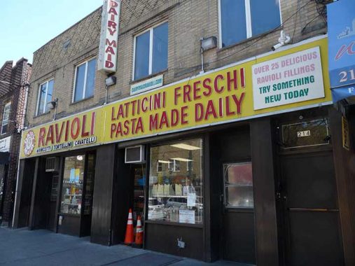
You can see a number of aged, or at least veteran, signs on Avenue U and when I’m around here, I always check to see how this vintage pasta shop sign is doing. The Italian could be translated as “fresh dairy products.” If I’m off, Comments are below.
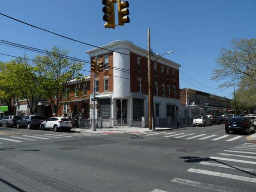
I suspected this corner building at #215 Avenue T at West 5th Street looked a lot different years ago, before most of its character was covered over. This 1940 photo proves I was right.
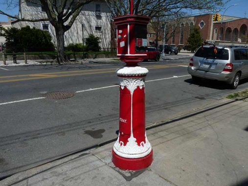
I encountered this recently painted fire alarm at Avenue T and West 3rd Street. It is likely the work of Woodside resident John Colgan, who has been restoring and beautifying vintage fire alarms around town for about a decade. He began in western Queens, but has been branching out around the five boroughs. He uses classic red and occasionally embellishes with white or gold.
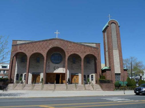
Sts. Simon and Jude Church, Avenue T between Lake and Van Sicklen Streets, heard its first Mass in 1899. The current modern structure was erected in 1966. I was attracted, though, to the rectory (priests’ residence) and parish grade school on the opposite side of the avenue. The school, now Coney Island Prep School, it was constructed in 1925 and boasts gorgeous marble and stained glass work. I was also impressed by the lettering, reminiscent of the ecclesiastic fonts designed by Frederic Goudy.
The inclusion of swastikas on the parish house should not cause alarm. Before the symbol was coopted by the Nazis, it was a symbol indicating good fortune. Keen-eyed observers will note the inclusion of the symbol on hundreds of older structures around NYC.
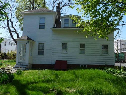
This is the Samuel Hubbard House, which may now justifiably be called the John Antonides House, at #2138 McDonald Avenue north of Avenue T. The right side of the house was built in the early 1800s (some researchers have said late 1700s) and was originally occupied by Nelly Hubbard and her son Samuel.
The house was purchased by Vincenzo Lucchelli in 1904 — he added the ell on the left side of the house in 1924. Lucchelli’s daughter Theresa occupied the house until her death in 1997, by which time the house was in very bad repair. Antonides purchased it, renovated it top to bottom, and was rewarded for his efforts when the Landmarks Preservation Commission landmarked it in early 2009, assuring the old place an even longer life. It’s especially notable because the LPC rarely cites buildings that have been heavily renovated.
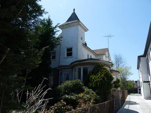
Though #106 Van Sicklen Street, north of Avenue S, has kept that grand circular sunroom in the front, it’s been altered somewhat from the way it was in 1940 and much detail has been lost.
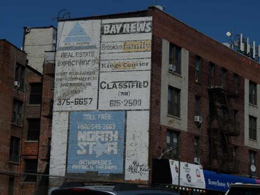
I went west on Kings Highway, which in the past I have referred to as “Brooklyn’s Mother Road.” Here are some painted ads overlooking the Sea Beach subway and clearly meant to be seen by people getting on and off at the Kings Highway station. Give them time, in 20 years they’ll be quite faded.
I have a fascination with this handsome, bay-windowed apartment block facing Kings Highway between West 8th and 9th Streets. Why? Several years ago, I acquired a photo of Kings Highway in 1909 when everything else except this building was pretty much empty lots.
Archie Ketchum Square is a small green triangle at the westernmost of Kings Highway’s two intersections with Quentin Road (I’ll get to why there are two intersections in a minute).
This square honors Archie C. Ketchum (1893-1920), a local Brooklyn native who worked in real estate with his father, volunteered for World War I, and served on the Board of Aldermen. Ketchum was raised on Kings Highway and West Eighth Street. He entered the real estate business with his father, Melvin Ketchum, but volunteered for service when the United States joined in World War I. A member of the 104th Field Artillery, Ketchum fell victim to gas warfare. Unable to return to duty, Ketchum was discharged and returned to his father’s Brooklyn real estate brokerage. In 1919, Ketchum was elected to the Board of Alderman (predecessor of the City Council), representing the Sixteenth Assembly District of Brooklyn, but only attended a few meetings before suffering a severe case of influenza, which led to emphysema. After suffering for three months, he died on April 18, 1920. NYC Parks
As for Quentin Road, ostensibly renamed in about 1920 from Avenue Q for Teddy Roosevelt’s aviator son killed during WWI, Kings Highway does indeed intersect it twice — as Kings Highway runs southeast then northeast, Quentin Road keeps an east-west straight line. A handsome Moderne apartment building can be seen on the corner of Quentin Road and West 9th.
Not so fast about Quentin Road. Some research I tapped into revealed that Tit was changed because on handwritten envelopes, Avenue Q was getting mixed up with Avenue O — and one of them had to be changed! I have that story here.
There are a number of interesting painted sidewalk signs on this stretch of Kings Highway, including one that indicates the presence of immigrants from the eastern European country Georgia. The name “Homestretch Inn” is a nod to the old Gravesend Race Track, gone since the 1910s.
I saw some late spring blossoms at Seth Low Park, a rather large expanse defined by Bay Parkway, Avenue P and West 12th Streets. Seth Low (1850-1916) was Mayor of the independent city of Brooklyn, achieving a number of reforms, from 1881-1884, president of Columbia University from 1890-1901 and Mayor of NYC from 1902-1904. Before 1895, this was the site of a large pond that was eventually filled in with construction ash.
As always, “comment…as you see fit.” I earn a small payment when you click on any ad on the site.
8/7/22

8 comments
Nobody knows NYC like Kevin Walsh.
SO true
I remember Spumoni Gardens well, as it was popular after school at Lafayette HS, that whole stretch of 86th St was my territory. And I remember dating a girl who lived on Lake at Van Sicklen, which was a little out of the way and not well known territory to me, though I do not remember her name. As for the pumping station, what is it pumping, do I recall there is an underground creek there that was built over? That sign on the deli on Kings Highway reads, Gastronom Kiev in Cyrillic, by the way.
My grandfather, who also served in WW1, was a member of the Ketchum Post of the VFW in Coney Island !
Born and raised in Bensonhurst, alumna of Seth Low! Great place to grow up in the 70s!
Wasn’t the West End Line El the one behind John Travolta as he walks down the street in Saturday Night Fever, another 1970’s movie people might remember?
Agreed Jill! My old neighborhood-60s and 70s. Lafayette HS and L&B. Thanks for posting this!
Back in the 70s I remember walking Lake Place from Van Sicklen Street at least as far as W 7th St. I remember thinking it was pretty cool that there was still a dirt road in Brooklyn. During the 19th Century, J. R. Lake, Jacobus Lake and William B. Lake all had property adjoining Lake Place. Jacobus Lake had also served as Gravesend Town Clerk.
I haven’t found any information as to the naming of Lama Court. It was known by that name at least as early as 1930 (based on newspapers) but nothing about who or what Lama was. In “Brooklyn by Name”, Benardo and Weiss offer that it may have been named by a developer for architect (and later Assemblyman) Alfred Lama. It is notable that there are clusters of short streets in Southern Brooklyn grouped around Shell Rd., Ocean Pkwy., Coney Island Ave. and a few other “fill-in” locations. A number of them have seemingly inexplicable names; names that could be developers, WW I veterans, local Party leaders or others.