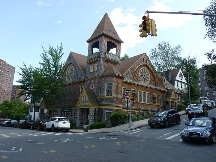
In a little-known quirk of geography, a small piece of the borough of Manhattan, known as Marble Hill, is on the mainland. It is surrounded on three sides by the Bronx and on the south by the Harlem River. It shares its character with the neighborhoods of Kingsbridge and Kingsbridge Heights on its north and east. It is protected from Spuyten Duyvil, on the west, by a steep hill.
Frederick Philipse built the first Kings Bridge, a tolled span over Spuyten Duyvil Creek, in 1693. Benjamin Palmer and Jacob Dyckman built a second bridge in 1759 to avoid paying the high tolls charged by Philipse. During his retreat from the Battle of Harlem Heights in 1776, General George Washington used both the King’s Bridge and Palmer and Dyckman’s free bridge to escape to White Plains. The original Kings Bridge has inspired a network of roads in Manhattan and the Bronx, some surviving, some not, named for it. The span survived till the excavations for the Harlem Ship Canal between 1913 and 1916
In 1895 it was separated from the island by the newly straightened, dredged and deepened Harlem River Ship Canal, leaving Marble Hill as an island itself. When, in about 1917, the creek was filled, Marble Hill became a part of the mainland! No one cared much until the el was built through Marble Hill and apartment buildings were constructed in the 1920s, joining the few frame houses that were already there. Marble Hill never changed its designation as part of Manhattan, and so a part of Manhattan it stays, separated from the rest of the borough by the Harlem River.
The oldest building remaining in Marble Hill is likely St. Stephen’s Methodist Episcopal Church, which as the cornerstone says, was built in 1897 (Alexander McMillan Welch). The congregation dates to 1826 in what would be the Mosholu Parkway area, moving to Riverdale in 1876.
The longtime pastor (1946-1977) of St. Stephen’s, Dr. William A. Tieck, was also a Bronx historian and founder of the Kingsbridge Historical Society. He wrote several historical books about the Bronx, including Riverdale, Kingsbridge Spuyten Duyvil New York City, A Historical Epitome of the Northwest Bronx. He preceded Lloyd Ultan as the official Bronx County Historian.
Much more in Marble Hill and its neighbor Inwood here.
As always, “comment…as you see fit.” I earn a small payment when you click on any ad on the site.
10/8/22


3 comments
“Benjamin Palmer and Jacob Dyckman built a second bridge in 1759 to avoid paying the high tolls charged by Philipse.”
Then as now, all tolls are obscene.
It doesn’t quite add up.
1875: City of New York and New York County annex what is now the Bronx west of the Bronx River. The boundary line is abolished.
1895: The Harlem River Ship Canal is opened, and the old Harlem River–Spuyten Duyvil Creek waters around the north of Marble Hill go dry.
1898: Borough of the Bronx is created, and THE NEW BOUNDARY IS SET WHERE A LINE WAS 23 YEARS EARLIER WHERE A RIVER USED TO BE.
What? Why? To whom did this make sense?
There must be a story here, but I have never found it. Someone
I suspect the residents of Marble Hill considered themselves Manhattanites, creek or no creek, bridge or no bridge. They likely refused to become the Bronx and there we have it. Much like Queens residents refusing to get rid of their old post office designations (Astoria, Jamaica and all that), New Yorkers can be a stubborn lot!