EMPLOYING a backlog of photos from the spring of 2019, when I got on the #2 train and took it all the way down to the last stop of Brooklyn College, then meandered in Midwood to the border of Flatlands and then west into Parkville where I clambered aboard the F train home. By some miracle, both lines were running normally on the weekend.
Only in Brooklyn can South Midwood be located north of Midwood. The name Midwood derives from the Dutch word, Midwout (middle woods), the name the settlers of New Netherland called the area of dense woodland midway between the towns of Boswyck (Bushwick) and Breuckelen (Brooklyn). Jan Snedeker, Jan Stryker, andTomys Swartwout solicited from Director-General Stuyvesant the right of settling together on a level area of wilderness (vlacke bosch), adjacent to the outlying farms at Breukelen and Nieuw Amersfoort. Through Swartwout’s suggestion, the settlement was named the village of Midwout or Midwolde. (info via wikipedia)
Today, Midwood’s borders are somewhat undefined but in general, the neighborhood lies south of Flatbush between Avenue I and Kings Highway and between McDonald Avenue and Nostrand Avenue; everything east of that can be called East Flatbush.
Midwood Park, meanwhile, was developed in 1908 by the John Corbin Company between Foster Avenue, avenue H, Coney Island and Ocean Avenues and has subdivisions called South and west Midwood.
I began at the corner of Flatbush Avenue and Avenue I where you can spot this pair of apartment blocks with stores at the bottom. In FNY I like to spotlight neighborhoods that don’t make the guidebooks. A partial reason for this is that I have a connection with many NYC neighborhoods, especially in Brooklyn. I grew up in Bay Ridge but spent a great deal of time downtown and in Brooklyn Heights where I attended college. I worked for the college paper (The St. Francis College Voice; don’t look for it online, it was discontinued years ago and who nows if the school still has a journalism major). Well, in the Super Seventies newspaper layout was done b y gluing blocks of text on boards and sending them off to the printer, which then printed the paper and delivered them to the school, and we used a storefront printer called Wells Graphics on Flatbush Avenue and Avenue I. The company may have gone out of business 40 years ago; there is still a press, Franklin Printing, on Flatbush Avenue near Avenue K.
Decades ago when bicycling through the area I noticed this group of attached homes on the north side of Avenue I between Flatbush Avenue and East 35th and was fascinated with their attention to detail. These kind of homes are usually found further to the north and west in Brooklyn, in Windsor Terrace, Bay Ridge, or Bensonhurst; plots in Midwood most often contain single family homes.

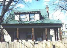
This Queen Anne-style house at the SE corner of Avenue I and Brooklyn Avenue has been considerably altered from when it was built during the first decades of the 20th Century, as were to a lesser degree the two homes on Avenue I facing Amersfort Park (see below). One is an example of what the British call “semi-detached,” or two houses divided by a wall on the same plot.

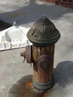
Throughout Brooklyn as well as the other four “outer boroughs” fire hydrants are not repainted frequently (though here in Little Neck, hydrants recently received a fresh coat of black and silver paint, the standard hydrant color combination in NYC). In 1976, homeowners who had hydrants in front of their homes often painted them with a red, white and blue Bicentennial motif, and this one still bears traces of this. The practice may be repeated as the USA celebrates its Semiquincentennial in 2026.

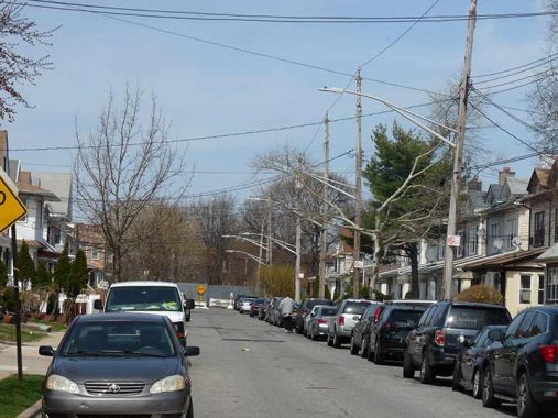
Twin-masted telephone pole masts are employed infrequently in NYC, but the dead end block of East 39th Street between Avenue I and the Long Island Rail Road has a flock of them.

Amersfort Park is a pleasant surprise if you’re passing through. It is atypical of NYC neighborhood parks in that there are no athletic fields or even jungle jims or swings — it’s just a pleasant green space with lawns, paths and benches. A former name for Flatlands is “New Amersfort” and the decorative stone monument in Amersfort Park is a copy of a 200,000-year old rock found in Amersfoort, Holland. The nickname for Amersfoort, Keistad (stone-city), originates in the Amersfoortse Kei, a boulder that was dragged into the city in 1661 by 400 people because of a bet. This story embarrassed the inhabitants, and they buried the boulder in the city, but after it was found again in 1903 it was placed on a prominent spot as a monument. The town is a province of Utrecht, from whence many colonial-era Dutch settlers hailed, and the namesake of New Utrecht Avenue in Borough Park. The name also pops up in Amersfort Place, a curving road that is a remnant of the old Flatbush Turnpike (see below) in the Brooklyn College area.
There had even been a third Amersfort in Brooklyn… the former Amersfort Avenue, which ran for a block from Avenue T at East 53rd Street south to Flatbush Avenue at Avenue U. In a true puzzler, after the nearby Kings Plaza Shopping Center opened in 1970, the then-Department of Traffic renamed it as a southern continuation of East 53rd Street, and the older East 53rd between Avenues T and U was then renamed East 53rd Place. Why the DOT didn’t leave well enough alone is beyond me.
I made my way west again on Avenue J where I found this incredible orange and black sign for a plumbing and heating place at Flatbush. The corner location and angled intersection allow plenty of space for signs. Unfortunately, though the sign was in good shape in 2019 it has been replaced by a newer sign.

Though #1263 East 37th featured stained-glass Hebrew characters it is actually home to Life In Messiah, an organization founded in the 19th Century promoting cooperation between Christians and Jews, as does the next door neighbor, In Search of Shalom. That building features two house numbers, #1265 East 37th and #1811 Flatbush, as it sits on the corner.
Nearby on both sides of Flatbush Avenue you will find interesting plastic lettered signs, including one for a mattress company that hasn’t been here for awhile.
Hubbard Place, named for one of Kings County’s longstanding farming families, runs in two sections from Flatbush Avenue south of Avenue K east to Kings Highway. The westernmost section, between Flatbush and East 40th, is laid out in a straight line and is fairly straightforward even though there are some interesting building designs that have been blunted by the application of aluminum siding…
…but east of East 40th Hubbard Place takes on a different aspect as it narrows and curves considerably, with parking on one side only with attached houses on its south side.

Hubbard Place, marked as Hubbard Lane on this 1873 map is old indeed and was part of the town center of Flatlands, one of the original five towns of Kings County (New Lots broke off from Flatbush to form a sixth; all were absorbed into the City of Brooklyn by 1895 and then into Greater New York in 1898). Since 1873, Flatbush Turnpike has been straightened into Flatbush Avenue.
Kings Highway, a Forgotten NY favorite; I call it “Brooklyn’s Mother Road,” has a complex history. As early as the mid-1600s it was used as a conveyance for British troops and went from Brooklyn Ferry at the end of Old Fulton Street at the East River southeast into Flatlands, where it turned west and ended in what is now Bay Ridge. In the early 20th Century, as Flatbush Avenue was established, the road that was called Flatbush Neck Road was renamed Kings Highway and is now part of the road that runs from Bensonhurst to Brownsville. By the early 20th Century Kings Highway’s Bay Ridge section had mostly died out.

Even as the modern street grid was built out, the old Flatlands town center remained discernible, amazingly enough, and Hubbard Place itself remains in places as does Flatlands Dutch Reformed Church.
Unfortunately one of Hubbard Place’s most historic buildings has been lost. The Aaron Van Pelt House, built about 1790, was demolished in 2003 and replaced by some attached homes that, while they are a cut above the usual Fedders Specials popular in the 21st Century, can’t replace a historic building.
http://bklyn-genealogy-info.stevemorse.org/Town/dutch/vanpeltwool.html

However, the Williamson House, built about 1865, can still be seen on the east end of Hubbard Place near Kings Highway.

Enjoy the solitude at the Flatlands Reformed Church and one of the oldest cemeteries in Brooklyn, north side of Kings Highway and East 40th. Whenever I have passed this way the gate was locked and I considered myself fortunate to enter for the first time.
There has been a church at Kings Highway and what is now East 40th Street since 1654, by order of the then ubiquitous Peter Stuyvesant. The original Flatlands Dutch Reformed Church was here until 1794; this building, the third church on the site, dates to 1848. The church’s original graveyard, with names like Lott, Wyckoff and Kouwenhoven but also some of Brooklyn’s earliest freed Blacks, is still in place.

From the original typewritten Landmarks designation report in 1966; later reports got infused with much more architect-speak and are tough reading for the layman.

According to the historic tablet placed here by the D.A.R in 1935, both British general Lord Cornwallis and George Washington used Kings Highway for troop movements and in Washington’s case, his tour of Long Island in 1790.
During the Roaring Twenties, Kings Highway between Ocean Avenue and East 98th Street was expanded into a 6-lane surface motor highway, albeit controlled by stoplights. Soon after, dozens of apartment buildings popped up along its length. Kings Highway is still a stronghold for Twin double-mast streetlamps.
Next time: west to Midwood and Parkville
As always, “comment…as you see fit.” I earn a small payment when you click on any ad on the site.
4/15/23


12 comments
I grew up on Foster and Argyle from 1962 until 1990. At that time we knew it all as Flatbush. Sometimes in the 70’s, it was called the Midwood section of Flatbush.
At one time Brownstone was considered to be the aluminum/vinyl
siding of its day
Let’s not forget that in Queens East Elmhurst is actually north of Elmhurst if you go between those two rather than east.
The Victorian-style houses with their turrets were once common in Flushing until they were replaced by numerous “attached houses” which may have been” modern” but lacked the presence of the turreted Victorians. Believe it or not, Prescott, AZ, the former territorial capital, has or had a few turreted homes &, at least when we visited ten years ago, were still owner-occupied. The Original Prescott Court building* was Victorian style, too. However, due to population growth, I fear that Prescott may have transformed itself the same way Flushing did fifty years ago.
* https://en.wikipedia.org/wiki/Prescott,_Arizona#/media/File:Prescott_Courthouse,_AZ_(ca_1885).jpg
Here’s more interesting Prescott architecture:
https://www.bing.com/images/search?view=detailV2&ccid=suw21g3I&id=C58E31C56493D8819E88E4372D4D9EE745CC4CD1&thid=OIP.suw21g3ItMTpHowxg8iV0AHaE7&mediaurl=https%3a%2f%2foldhousecalling.com%2fwp-content%2fuploads%2f2021%2f04%2f4528b0e4023daff94eebdbd0b577a7cbl-m2756985445od-w1024_h768.jpg&cdnurl=https%3a%2f%2fth.bing.com%2fth%2fid%2fR.b2ec36d60dc8b4c4e91e8c3183c895d0%3frik%3d0UzMReeeTS035A%26pid%3dImgRaw%26r%3d0&exph=682&expw=1024&q=prescott%2c+az%2fvictorian+style+homes&simid=608034809696101780&FORM=IRPRST&ck=04C7FA65418544024250604B7E7A9CD6&selectedIndex=0&idpp=overlayview&ajaxhist=0&ajaxserp=0
I lived at E. 34th St. and Ave. H, just about 4 blocks or so from Flatbush Ave.. I thought of it as Flatbush when I was growing up there. Would that still be considered within Flatbush….or E. Flatbush….or Midwood?
Everyone I meet from Brooklyn always seems to be from Flatbush
Eric, “The Neighborhoods of Brooklyn” shows East 34th between Glenwood Road and Avenue H as East Flatbush. South of Avenue H on 34th is Flatlands.
Hmmm… How many buildings in NYC have two house numbers/addresses? We’re talking two “legitimate” addresses because they’re on a corner, or maybe they’re still remembered and called by an old address, not something honorific like “One Skyscraper Boulevard.”
I know for sure of an instance (and there may be many others, of course) where the main entrance to a detached one-family house on a corner lot is on an avenue, but the address is that of the cross street.
That’s common enough in the suburbs, particularly when they angle a corner house so you have to play Stump the Expert and guess as to what house number, and what street the house belongs on. Makes deliveries difficult.
Kevin, The building with Hebrew letters.”.Life in Messiah” is not promoting better understanding between Christians and Jews.
It is part of the messianic movement to convert Jews to Christianity.
So according to Neighborhoods of Brooklyn, I lived my first two years in Flatlands. That’s what my father called it too, and he was a Brooklyn boy, so I’m fine with that definition. East 33rd a few doors south of Kings Highway. Google has decided to call the neighborhood Marine Park, less imaginative than some of Google’s place names since it not far from the park of that name.