


SINCE I haven’t been able to get out much, I have decided to continue my recently minted series Where It All Begins, that employs the magic of Google Street View to capture the beginnings (and in some cases, ends) of some lengthy roads in the five boroughs, since I enjoyed the first one so much. It may evolve into a multipart series, but I won’t return to it every week lest things get scale or you the reader tire of it if it appears too often. My original concept was to cover roads whose beginnings are markedly different than the rest of the road, but I will have to expand that concept a bit. However, if a Beginning is too boring (in my opinion), I won’t include it.
The Many Faces of Conner Street

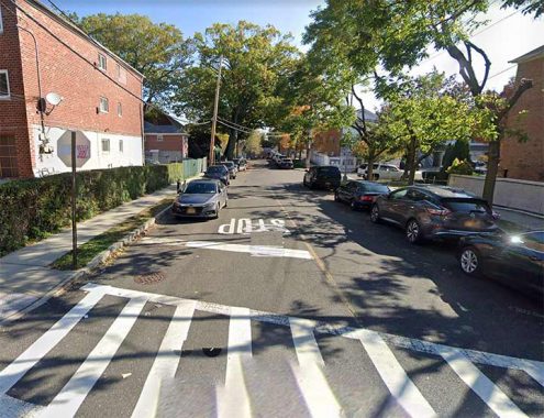
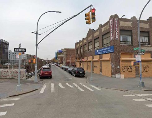
One of the shorter roads on today’s list, Conner Street is in Eastchester in the far north Bronx and begins at Pratt Avenue, running a couple of shady, residential blocks to Secor Avenue…

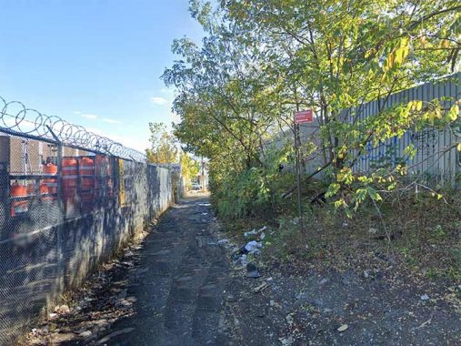
After an interruption for the northern end of the Dyre Avenue line serving the #5 train (actially a portion of the old New York, Westchester & Boston Railroad) Conner Street begins again at Dyre Avenue and narrows considerably and runs for a few blocks between an auto collision towing company and some undeveloped property…


…but once it meets Provost Avenue and Boston Road, it becomes a 4-lane truck route, crossing over the New England Thruway and eventually, via Peartree Avenue, reaching the east end of Co-Op City.
According to Bronx historian John McNamara in “History in Asphalt” Conner Street was named for a J. Conner and the area was informally known as Connersville. The street was mapped in 1871 and once supported a trolley line that ran to an amusement park called Eagle Grove.

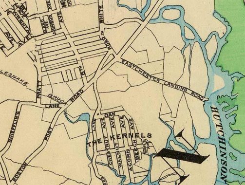
On this 1901 map excerpt, Conner Street appears as one of the unnamed streets issuing east from Pratt Avenue. Boston Road was then known as Boston Post Road, as it still is in Westchester County. Conner Street was once Eastchester Landing Road and led down to the Hutchinson River.
What were “The Kernels”? I discuss that on this FNY page.
Westchester Avenue

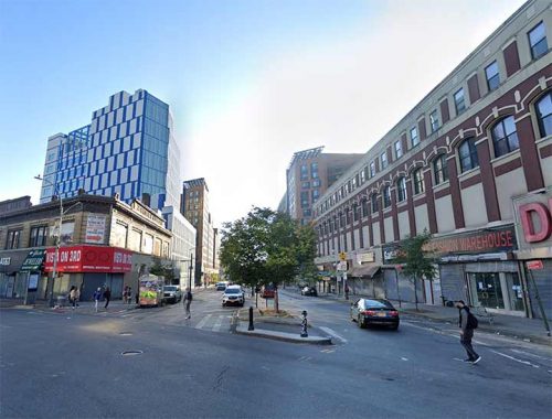
Westchester Avenue begins in sunshine at Third (in the Bronx, it’s spelled out) Avenue just north of East 149th Street in the heart of The Hub and rolls through Longwood, Castle Hill, Parkchester, Westchester Square all the way to Pelham Bay Park. It’s the only NYC street that has two separate elevated lines running above it, the north end of the 7th Avenue/Broadway IRT serving the #2 and #5 trains, and the north end of the Lexington Avenue IRT serving the #6 train. And, it used to begin at an elevated, as until 1973 the northern end of the Third Avenue El was still running in the Bronx.
Westchester Avenue is a very old road; according to the the great Bronx historian John McNamara in History in Asphalt, it was first traced in the colonial era as a path from the Morris family estate to the town of Westchester, whose seat is now called Westchester Square. Until 1874 all of the Bronx was located in Westchester County; it became part of NYC in sections, with most of the Bronx west of the Bronx River annexed that year, east of the Bronx River in 1895 (City Island the following year). The whole territory became the Borough of the Bronx when Greater New York was created in 1898, and finally, the Bronx became a county on its own in 1914.
Westchester Avenue was graded from Coles’ Boston Road (now Third Avenue) to the town of Westchester in 1867, when it was known as the Southern Westchester Turnpike (to differentiate it from Westchester Turnpike proper, now followed in great part by US Route 1). Sometime before the turn of the century, as the area gradually urbanized, the name was changed to Westchester Avenue.
Jerome Avenue


Jerome Avenue is another of The Bronx’s streets that begin in sunshine, but wind up mostly shrouded under an elevated train. Here it is pictured at the Major Deegan Expressway, just north of the Macombs Dam Bridge; lengthy Bronx roads Sedgwick and Ogden Avenues also begin at the same spot. Jerome Avenue immediately encounters the rear of the New Yankee Stadium and runs through Mount Hope, Tremont, Fordham, Bedford Park and Norwood. A mile or two at the south end are in sunshine and you will find some exquisite apartment houses in that section; but in a mile and a half it encounters a northern branch of the Lexington Avenue IRT serving the #4 train, and it’s mostly industrial and commercial under the el, which continues all the way north to Woodlawn Cemetery.
Other than a slight bend in Bedford Park, Jerome Avenue doesn’t see the sun again till it gets to Woodlawn, and runs between it and Van Cortlandt Park until re-encountering the Deegan at East 233rd.
Leonard Jerome (1817-1891) was a wealthy financier and horse racing enthusiast. Jerome was born in upstate Onondaga County and after graduating Princeton, became a successful stock speculator, investing in railroads in which Commodore Cornelius Vanderbilt was a partner. For a time he resided in Brooklyn, but then built the Jerome Mansion at Madison Avenue and East 26th Street, which stood until 1967. The Jerome Park Reservoir is built on the former site of the Jerome Park Racetrack, where the Belmont Stakes formerly took place. Jerome, the grandfather of wartime British prime minister Winston Churchill, is entombed in Green-Wood Cemetery in Brooklyn.
Lafayette Avenue

There are a pair of Bronx avenues that begin in Hunt’s Point and run all the way to Eastchester Bay in Schuylerville, with several interruptions. Lafayette Avenue, shown here where it begins at the Bruckner Expressway, is stopped cold by the Bronx River (older maps show a bridge over the river, but that was a developer’s dream). Lafayette Avenue is interrupted again by Soundview Park and Westchester Creek and between St. Joseph’s School for the Deaf and St. Raymond Cemetery all the way to Eastchester Bay. It attained its full length in the 1920s.
Gilbert du Motier, Marquis de Lafayette (1754-1834) was a wealthy nobleman and military commander, a staunch ally of the USA and became a close friend of George Washington, and his aid enabled the USA to win several crucial battles, most notably the Battle of Yorktown. France wavered in its support of the USA after the Revolution, but Lafayette continued on as a legendary and revered figure in the USA. He returned for a triumphal visit in 1824. During the Revolutionary War, he was only in his early 20s at the outset.
Randall Avenue


One of the Bronx’s longer streets, Randall Avenue takes a similar path to Lafayette Avenue a little south of it, beginning at Truxton Street. However, it is absent on the map for long stretches, due to the Hunts Point Produce Market and St. Raymond Cemetery, and is again interrupted by two bodies of water.
The Hunts Point section is the oldest and the avenue was built east from there. According to McNamara, its name recalls the Civil War-era Brigadier General George W. Randall.However, I find no reference to that name anywhere; instead, I find General George Morton Randall (1841-1918), who served with distinction in the Civil and Indian Wars. However, since Gen. Randall died in 1918 and Randall Avenue was named before that, I have my doubts; streets are usually named after the namesake’s death. Any opinions? Comments are open.
Park Avenue

Park Avenue is something of a Frankenstein’s Monster of Manhattan and Bronx avenues, as it was put together from a number of different parts. In both boroughs, it runs along, above or below the NY Central Railroad, now a part of the MTA branch Metro-North. In Manhattan, the complete length of the road was known as 4th Avenue when mapped in 1811.
4th Avenue’s physical history is defined, in large part, by the coming of the iron horse in the mid-19th Century. By 1832 the New York and Harlem Railroad ran on The Bowery, pulled by real horses that far downtown, from about Centre Street north to 14th. The line intended to reach Harlem, and thecity permitted the NY&HRR to extend north along what would become 4th Avenue, then still a figment of city planners’ imaginations. Railroads at the time were filthy, noisy and dangerous, especially in a burgeoning urban environment, and only the poor and the attendant crime element would live along the route.
The city could take no more. Something had to be done –and the city took action. A tunnel was cut between East 33rd and 38th Streets in the 1850s to contain the steam belchers, and the city placed a landscaped garden path above the cut, renaming 4th Avenue Park Avenue at that point.
Eventually the city made 42nd Street the furthest point south the steam rails could travel, believing falsely that civilization would never extend north of there (a mistake the city had previously made decades earlier by placing City Hall at the junction of Broadway and the Bowery Road). The city continued to relentlessly expand, however, and steam railroads continued to plague an increasingly genteel district.
The city continued to rename the route Park Avenue in sections above that point. By 1896, even the sections of road in the Bronx alongside the railroad, now either elevated, in a tunnel, or in an open cut, were renamed Park Avenue, and today, walking along gritty Park Avenue in, say, Morrisania or Fordham, you have to remind yourself that this is indeed the same Park Avenue that accommodates the Lever House and St. Batholomew’s Church a few miles to the south.
Cooper Street/Cooper Avenue


Like Grand Street and Grand Avenue, which run from Williamsburg to Maspeth, Cooper is called a “Street” in Brooklyn, but once reaching the Brooklyn-Queens borough line at Irving Avenue, it becomes an Avenue. It widens gradually and runs in a northeast route through Ridgewood and Glendale and eventually knocks on the door of Forest Hills as it ends at Woodhaven Boulevard. For over a decade, a pair of attached homes on Cooper Avenue south of St. John’s Cemetery stood in for “Archie Bunker’s Place” as the closing credits for “All in the Family” rolled. It is a very old road…it takes exactly the same route as the road from Bushwick to Newtown as shown on this 1852 Dripps map of Brooklyn and Queens.
The origin of the name isn’t mentioned in any of my sources, but my guess is industrialist/philanthropist Peter Cooper, whose name loomed large in 19th-Century Brooklyn and Manhattan.
Manor Road

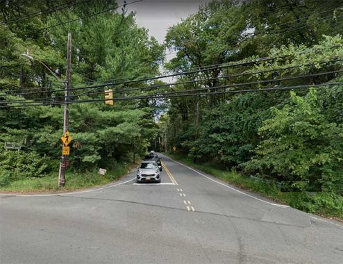
Manor Road is a modest two-lane road originating at the Port Richmond-West New Brighton border and runs south (past some of Staten Island’s handsomest private homes) through Castleton Corners. At Brielle Avenue, though, it becomes a country road in the city, moving mainly un-intersected at the western edge of Todt Hill and past the Pouch Boy Scout camp ands the back end of the Seaview Hospital complex before ending at Rockland Avenue. From there, traffic can proceed on Meisner Avenue south into Lighthouse Hill.
Richmond Road

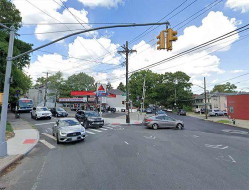
Just as the Ohio River originates at the confluence of the Allegheny and Monongahela at the Golden Triangle in Pittsburgh, Richmond Road begins at the confluence of Van Duzer Street and Vanderbilt Avenue (named for the Vanderbilt family and its scion, transit magnate Commodore Cornelius Vanderbilt, who organized one of the first, if not the first, ferries between Manhattan and Staten Island).
It is an old road indeed and dates from the colonial era, perhaps before that as a Native American trail. It hosted the first stagecoach route on the island. and skirts the south side of Staten Island’s extensive mid-island hilly area consisting of Grymes, Emerson, Todt and Lighthouse Hills. It finishes at another confluence of roads, Richmond Hill and Arthur Kill, in the heart of historic Richmondtown.
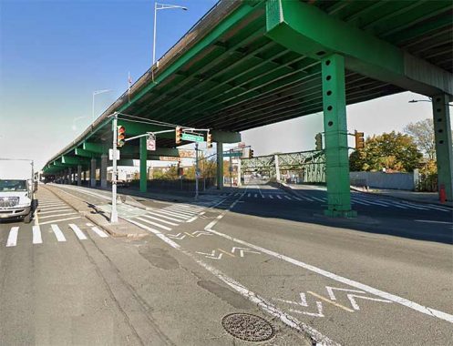
Northern Boulevard


The beginning of Northern Boulevard at Queens Plaza beneath the Astoria elevated (serving N and W trains) looks nothing like the rest of the road, which roars along the northern tier of Queens, hence its name. It runs along the Sunnyside RR yards, Jackson Heights, past Citifield, through the heart of old Flushing, and out east through Bayside, Douglaston and Little Neck. East of the Queens line the nomenclature gets murky, as nowadays the road up to the Nassau-Suffolk line is still called Northern Boulevard: though some signposts have its older name, North Hempstead Turnpike (not to be confused with the old name of Booth Memorial Avenue).
Most suburbanites simply call the road 25A, for New York State Route 25A. With that designation, the road runs through mid-Suffolk until past Calverton Cemetery when it joins NYS Route 25, known in various stretches as Jamaica Avenue, Jericho Turnpike and Middle Country Road. Route 25 proceeds to Orient Point on the eastern tip of the North Fork.
Sunrise Highway


Sort of Long Island’s suburban answer to Sunset Boulevard, which follows the setting sun west in Los Angeles, Sunrise Highway does the opposite through Nassau and Suffolk. NYC State Route 27 extends out to Montauk Point nearly 100 miles east and is called Sunrise Highway as far as Shinnecock Hills. There is a short section of approximately one mile in Queens.
In Laurelton, The Belt Parkway turns north, becoming Laurelton and Cross Island Parkways. However its service roads, North and South Conduit Avenues, continue east, and the Sunrise Highway moniker is applied to the westbound, or north service road, as far west as the junction with the Belt. (North Conduit Avenue is present as well, as a residential street ending at Hook Creek Boulevard). Once past the undefended border of Nassau County, South Conduit Avenue becomes the eastbound lane of Sunrise Highway.
As always, “comment…as you see fit.” I earn a small payment when you click on any ad on the site.
5/21/23