

BEGINNING a series here that I will return to from time to time about where NYC’s longest roads originate. My aim here is to show the “sources” of roads and especially those that don’t look like the rest of the road in question; many begin as trickles, and then develop into mighty multilane thoroughfares. One of the starkest examples (not included on this page; maybe the next one) is Conner Street way up in the Eastchester area in the Bronx, which is a one-lane pathway on one side of Boston Road and a six-lane boulevard on the other! After nearly 60 years of staring at maps, I have always been fascinated on how lengthy roads change character from area to area. Here are just a few of them today.

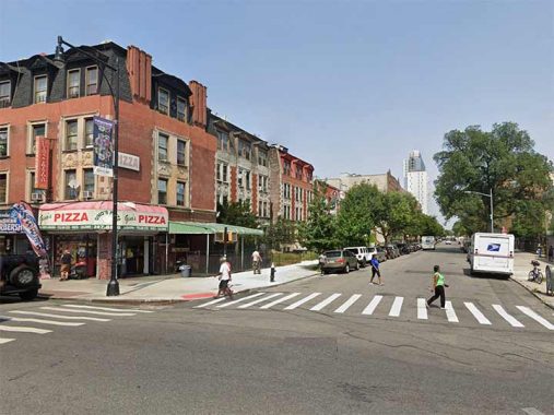
Williamsbridge Road
Named for a neighborhood and a former bridge over the Bronx River, Williamsbridge Road begins at Adee Avenue just east of White Plains Road and meanders around a bit on a curved path before settling on a generally southeast direction at Matthews Avenue. It gains some width at Boston Road and then roars down to Westchester Square. Actually, this is the northern end of the road, as in the Bronx, house numbering generally goes from south to north; east to west house numbering is delineated by Jerome Avenue.
The road is named for John Williams’ colonial-era farm and the bridge on his property that crossed the Bronx River. The bridge is still spelled “Williams’ Bridge” on some signage.
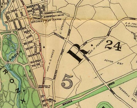
This 1901 map shows the north end of Williamsbridge Road as it ran through open country and farmland. Amazingly the road follows exactly the same path today as the street grid was constructed around it. The late Bronx historian John McNamara, in “History in Asphalt,” says the road predated the colonial era as a Native American trail.
Tremont Avenue

Yes, there’s an East and West Tremont Avenue, divided by Jerome Avenue, and I have walked East Tremont from the Grand Concourse to Westchester Square. But when I get the chance, I’ll want to walk West Tremont, the most fascinating section because it has to traverse some high hills and even runs north at one point to do so!
The west end of West Tremont Avenue gets you into Roberto Clemente State Park at the Harlem River. Named for the Pittsburgh Pirates star who perished in a plane crash on New Year’s Eve 1972 en route to earthquake-ravaged Managua, Nicaragua, to assist in relief efforts, Roberto Clemente State Park, at West Tremont Avenue and Matthewson Road, is the only major recreation area in densely-populated northern Morris Heights. It occupies 25 acres along the Harlem River and features an outdoor aquatics center, ballfields and picnic areas. Washington and High Bridges can be seen in spectacular fashion from the riverside park. Enter via West Tremont Avenue past the Morris Heights Metro North station.
During his 18-year major league career, Clemente starred in two World Series, was a four-time National League batting champion, and won the Most Valuable Player Award in 1966. Two months before his death, he collected his 3,000th hit against the Mets’ Jon Matlack; he was inducted into the Baseball Hall of Fame in 1973.
Like many of NYC’s long roads, East Tremont Avenue was put together in pieces, taking over the northeast end of West Farms Road between the Bronx River and Westchester Square and, south of that, Fort Schuyler Road. It was known as East Tremont Avenue for the entire distance by 1920.
Bruckner Boulevard


The beginnings of Bruckner Boulevard are two narrow lanes, one going east and the other west, at Third Avenue (it’s spelled out in the Bronx) under the Third Avenue Bridge over the Harlem River., on either side of a westbound ramp connecting the boulevard with the bridge.
After a modest beginning here, the boulevard is on its own in Mott Haven, but becomes the east and westbound service road of the Bruckner Expressway, built for the most part from 1957 to 1961. The newer road, though, follows the path of Eastern Boulevard, which was formulated fro the 1900s to the 1920s by linking East 133rd Street, Whitlock Avenue, Ludlow Avenue and Willow Lane in Middletown; the section in Unionport didn’t appear until the 1920s as the area was quite swampy.
6th Avenue
Today, 6th Avenue (a.k.a Avenue of the Americas) is the southernmost numbered avenue on the overall grid, but it’s held the title only since 1928, and it took the construction of the IND subway, supporting the A, C and E lines, to get it there. Prior to that, 6th Avenue ended at Carmine and Minetta Lane. The coming of subway lines in Manhattan served to extend both 6th and 7th Avenues south: the IRT was built south along the course of 7th Avenue South in the early 1910s, while Independent Rapid Transit, constructed by NYC, was run south along 6th Avenue into SoHo in the mid to late 1920s. Instead of restoring houses and businesses that were demolished to make way for the trains, the city elected to make more direct routes from Midtown to southern Manhattan and build roads over what had been open subway cuts.
To extend 6th Avenue south, the city had to redo the house numbers of all of 6th Avenue’s buildings, as #1 6th Avenue was relocated to the intersection of Church and Franklin Streets. (When 7th Avenue was extended south a decade previously the new section was called 7th Avenue South). Additionally, a number of small streets in Greenwich Village were absorbed by the new 6th Avenue section.
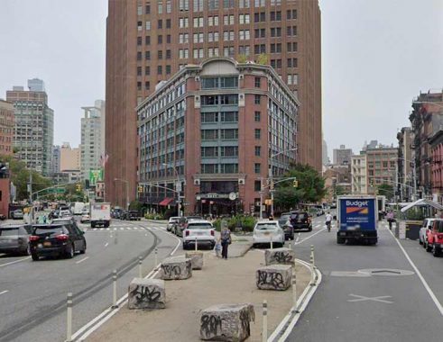
The Roxy Hotel, famed for its jazz club, sits at the fork formed by 6th Avenue and Church Street.
Fulton Street

At the Fulton Ferry landing in DUMBO, the west end of Fulton Street hasn’t borne that name since the 1950s. Known as Fulton Street since the mid-1800s, it was slapped with the moniker “Cadman Plaza West” in the 1950s as Fulton Street ran along the plaza’s west end. Here, though, that name made no sense, because Cadman Plaza is located entirely to the south of Prospect Street. The Department of Transportation corrected the situation somewhat by renaming the DUMBO section of Cadman Plaza West as “Old Fulton Street” in the 1980s.
From here, Old Fulton/Cadman Plaza west/Fulton Street runs southeast and east, becoming a main commercial strip in Fort Greene, Clinton Hill, Bedford-Stuyvesant and East New York all the way to Eldert Lane, where it becomes 91st Avenue.
Bedford Avenue

What’s the longest street that runs entirely in Brooklyn? It seems there are two candidates: Flatbush Avenue and Bedford Avenue. (Any drivers out there want to decide the matter using their odometers?) Some roads running east-west are pretty lengthy, but they extend all the way to Queens and beyond: Linden Boulevard (see below), Myrtle, Metropolitan, Atlantic, and Jamaica Avenue, which, under a variety of names goes all the way to Orient Point at the tip of Long Island.
Bedford Avenue, however, runs through more architectural styles, demographic groups, and neighborhoods than any other Brooklyn street. Beginning in Greenpoint, except for a bend following the East River in Williamsburg, it heads south in a relatively straight line through Bedford-Stuyvesant, Crown Heights, Prospect-Lefferts Gardens, Flatbush, Midwood, and Sheepshead Bay and other neighborhoods.
The name Bedford’s origins are in Brooklyn’s dim past; it could have been named for Britain’s Bedfordshire, or the village of Bedford (as Bedford Park in The Bronx was) or it may be an English version of the Dutch Bestevaar, “place where old men meet.” Bedford Avenue was called 4th Street in Williamsburg and Perry Avenue south of Fulton Street until the mid to late 1800s, but by the 1890s its full length had been established.
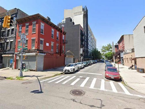
In the above photo, One Bedford, the first address (the last one is in the 4000s) is the triangle building on the left, at Manhattan Avenue, home to Frankel, an “appetizing” shop selling Jewish deli treats.
I have walked the entire length of Bedford Avenue in three sections.
Metropolitan Avenue
Metropolitan Avenue is one of the lengthiest routes between Brooklyn and Queens. It was first built in 1815, give or take a year, as a toll road and was known along much of its length (at its west end as North 2nd initially) as the Williamsburg and Jamaica Turnpike until the mid-1800s, when it was bestowed its current name. It runs from the East River to Jamaica Avenue and along the way, marks the southern limit of Newtown Creek, and runs through Lutheran/All-Faiths and St. John’s Cemeteries, as well as Forest Park. It’s the spine of several communities — Williamsburg, Middle Village (so named because it was midway between Williamsburg and Jamaica), and Kew Gardens, and forms the boundary line between Ridgewood and Maspeth.
I walked its entire length in one day in May 2015.
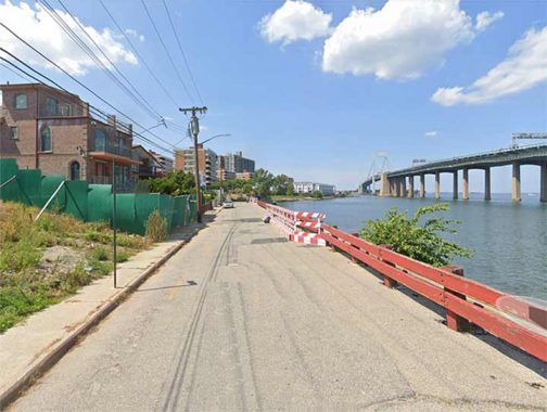
Kent Avenue
At its south end at DeKalb Avenue in Clinton Hill, just east of Pratt Institute, Kent Avenue looks quite similar to one of its parellel side streets; it isn’t until it passes the BQE that it becomes notable, curving along the east end of the Brooklyn Navy Yard, Wallabout Bay and the East River to Greenpoint, where it becomes Franklin Street.
Few streets have changed character in recent years quite like Kent Avenue. It has gone from an industrial no man’s land punctuated by railroads to a posh, tony high rise apartment mecca, as a zoning change in 2005 prompted the construction of luxury towers along the river. These have been accompanied by new parks and ferry stops allowing more Brooklynites access to the river that they never had had before.
My first glimpse of Kent Avenue was in a van. My high school bowling team’s league played at a long forgotten lanes at Humboldt and Moultrie in Greenpoint (I have forgotten the name; if anyone remembers, Comments are below). We either trundled up Kent Avenue in a nearly broken down van or took the G train to Greenpoint Avenue and schlepped 12 blocks from there.
Despite never getting my average over 150, I played for both my high school and collegiate bowling teams. I never mastered a hook and just heaved the ball down the middle, which is a good way to get a lot of splits. I am a lettered college athlete, despite never being able to run more than 5 blocks or pick up anything heavier than 30 pounds.
Linden Boulevard
From beginning to end, from Brooklyn through Queens and into Nassau County, Linden Boulevard is one of NYC’s lengthiest thoroughfares, running a total of 12.3 miles. However it’s also unique among NYC’s longest streets. It’s made up of varying widths, from a one-lane trickle to a 10-lane superbehemoth to a regular two-lane street. Alone among NYC’s major named streets, it roars for miles, comes to a stop, begins again in fits and starts before roaring to a close. Though I don’t drive at all, I’ve always been fascinated with this unique thoroughfare. When I lived in Brooklyn, I found it a fast way to get from Ozone East New York to Flatbush along its busiest stretch.
In the 1920s, traffic engineers decided to extend Linden Avenue east past Kings Highway, which they were also widening, and make it into a surface expressway of sorts. The new Linden Boulevard would scythe through the NW-SE traffic grid and then jog temporarily northeast to avoid the curve of the Long Island Railroad, which would ultimately be bridged over it. In East New York, Linden Boulevard would assume the routes of Hegeman and Vienna Avenues (later renamed Lorrain and then Loring).
After an interruption in Ozone Park and for the Aqueduct Raceway, Linden Boulevard resumes at Rockaway Boulevard, largely along what was once called Central Avenue, and enters Nassau County, becoming a three-county road, finally ending at the Southern (State) Parkway.
Utopia Parkway
Utopia Parkway, a main north-south route in Whitestone, Auburndale and Fresh Meadows, begins as a trickle of a road along Little Neck Bay within view of the Throg(g)s Neck Bridge. It quickly gains steam, though, after crossing the Cross Island Parkway. South of Grand Central Parkway, it becomes Homelawn Street.
In 1905, the Utopia Land Company purchased 50 acres east of the Flushing-Jamaica trolley line (now 164th Street) in today’s Fresh Meadows, planning to build cooperative homes for Jewish people then living on the Lower East Side. The streets were named for several in the Manhattan neighborhood, including Houston, Stanton, Rivington and Delancey. Work had begun, but the company went bankrupt before any housing was constructed, and the region remained woods, meadows and farmland until the 1940s, when the neighborhood was built up by the Gross-Morton Park Corporation with Colonial and Cape Cod-style homes.
Now a part of greater Fresh Meadows, the area’s main north-south main drag, Utopia Parkway, was not completed until the late 40s, replacing the previous main artery, Fresh Meadow Lane, which now fills a subsidiary role. NYC-based rock group Fountains Of Wayne were sufficiently inspired by the fanciful-sounding street to name their second album after it in 1999.
Richmond Avenue

Richmond Avenue is the main north-south route in Staten Island, a borough whose major roads such as Richmond Terrace, Victory Boulevard, Hylan Boulevard et al g mostly east-west. It runs from Willowbrook Parkway south through Willowbrook, New Springville and Eltingville to Raritan Bay. Its north end, though, is distinctly unusual.
Formerly, Richmond Avenue ran all the way north to Port Richmond and until the Staten Island Mall opened was a staple shopping street in that neighborhood. When buses from Brooklyn began running across the Verrazzano Bridge, its chief destinations were Clove Lakes Park and Port Richmond. In the 1970s, after the Mall had opened and the city was trying to revitalize Port Richmond, Richmond Avenue between Richmond Terrace and Forest Avenue became Port Richmond Avenue.

This 1873 map shows the junction of Richmond Avenue and Forest Avenue. The latter, still called Cherry Lane, stopped at Willowbrook Road but was later joined to Washington Avenue at the left side of the map to create a continuous Forest Avenue.
Meanwhile, Richmond Avenue made a slight curve to Morningstar Road and then plunged south in the route it takes today. By the early 20th Century it had absorbed other roads and became the continuous Richmond Avenue of today. It was greatly widened to as many as six lanes when the Staten Island Mall was built in the 1970s.
Today, the Willowbrook Parkway, en route to the Bayonne Bridge, cuts across the bend in the road marked “Church Road.” The little curve of Richmond Avenue west of the parkway is still there and was not renamed, and thus is now the “beginning” of Richmond Avenue.
As always, “comment…as you see fit.” I earn a small payment when you click on any ad on the site.
5/14/23
12 comments
When I was a little kid in the late 40s early 50s my father had a panel.truck that was forbidden on the Belt so we took Linden to visit relatives in Longiland (one word). And I remember seeing.
farmland with cultivated rows, and goats.
Richmond Avenue-
Willowbrook Parkway was renamed Martin Luther Parkway over 30 years ago ….
To be exact, it was renamed the Marthin Luther King, Jr Expressway after the slain civil rights leader, not Martin Luther of the Protestant Reformation. That being said, like many renamed streets and highways, most locals still refer to it as the Willowbrook Expressway.
Thank you for another very entertaining posting. I, too, have never tired of viewing and consulting conventional paper maps, which to me never cease to be a forever learning experience. That’s why I rarely need a map when I’m in familiar territory such as NYC or Long Island, whether driving, walking, or using transit. I almost never use GPS; my wife often says that she married Mapquest.
A bit more about Bruckner Boulevard. This thoroughfare was named for Henry Bruckner (1871-1942), a Bronx native who served as a US Congressman (1912-1917) and then was Bronx Borough President 1918-1934. Bruckner was also in the carbonated beverage business. Eastern Boulevard was re-christened Bruckner Boulevard in the late 1940s, about a decade after the route was widened to provide a northeast approach roadway to and from the Triborough Bridge, which had opened in 1936. Bruckner Boulevard was notable for its Triborough-type lampposts installed at that time. When the Boulevard was rebuilt into its Expressway iteration in the 1960s, most of those lampposts disappeared.
More about Henry Bruckner: https://en.wikipedia.org/wiki/Henry_Bruckner
My paternal grandparents lived at 3051 Williamsbridge Rd. one block from the camera placement in the photo. Even as a kid I thought it odd that the street was so narrow and unremarkable there when it’s a major street on the other side of Pelham Parkway.
And dont forget Joseph Cornell lived his entire life on Utopia Pkwy
About Bedford Av: It was impacted by the “Great One-Waying” (my terminology) of Sept. 8, 1963, which impacted many streets in Brooklyn and Manhattan. Bedford Av. was made to be northbound north of Atlantic Av (later, the one way was moved to begin at Bergen St., as it is today). Bedford Av. was already a one-way north of Division Av, but ran southbound! So its direction was reversed.
Re: Sixth Avenue
Fox News Channel which is located at Forty-Ninth St. & 6th Avenue, uses its great view from Fox Squiare to show a portion of 6th Avenue looking north to Central Park South. Although it’s not a point of origin, this view
is probably 6th Avenue’s best portion IMHO.
Broadway, beginning at the Batterey in lower Manhattan, is the beginning of the Albany Post Road. Follow it up to Columbus Circle then over to the west side entering the Bronx at Marble Hill. It may change names to South or
North Broadway but stick with it into Yonkers. Through Tarrytown, where I lived for a year at 181 South Broadway it finally gets the name Albany Post Road around Rockwood Hall just past Sleepy Hollow.
Just north of Ossining
Broadway (now Albany or Old Albany Post Road) leaves Route 9 and becomes a more rural road. It basically parallels Route 9A. It is along about Poughkeepsie where you can still spot the stone markrs showing distance to Albany and back to New York City. I envision mail carriers from Ben Franklin’s time using the markers.
Somewhere around Hudson ,N.Y. Follow Route 9H which has several offshoots called “Old Post Road.”
I assume around Schodack Center that the Albany Post Road follows Greenwood Turnpike (again Rt 9) into
Albany. A nice little 147 mile hike; I have only done the Manhattan to Scarborough piece.
For such a well-known thoroughfare Fifth Avenue begins rather inauspiciously at W. 143rd.
That;s because its north end is cut off as the Harlem River flows uptown in a SE to NW direction, forcing Manhattan island to become narrower and narrower. Fifth Avenue’s south end is quite auspicious, at the Washington Square arch. But even that site had a very ordinary beginning, as a potter’s field.
What some don’t know is that Flatbush Avenue doesn’t really start from the Manhattan Bridge, it starts from Fulton Street, while that portion going up the bridge between that is known as Flatbush Avenue Extension.