
It occurs to me that I haven’t done an entry in the Forgotten NY Street Necrology category for awhile, and in this case, I want to do something a bit different. Instead of talking about streets that formerly existed and were wiped out, I’ll mention some streets and routes that were included on maps and for whatever reason, were never constructed. I’ve been able to track down some of these in each borough except the Bronx and Queens and since this will likely wind up as a periodic series, there’s no reason for the Mainland Borough and the Biggest Borough to get left out.

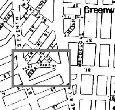
Verrazano Street was mapped in the 1960s along with the Lower Manhattan Expressway (LOMEX) which was going to connect the Williamsburg and Manhattan Bridges with the Holland Tunnel via elevated roadways above Broome and Delancey and in a corridor between the Bowery and Chrystie Street.This grand dream of traffic czar Robert Moses was quashed by area residents, as it would have forced the teardown of hundreds of buildings, forcing residents to move. This method hadn’t stopped Moses in other boroughs, but Manhattan was a tougher nut to crack. The prevention of LOMEX paved the way for what some would term gentrification, but the revival of SoHo into a premier commercial/residential area after the death of LOMEX in 1969 was undeniable.
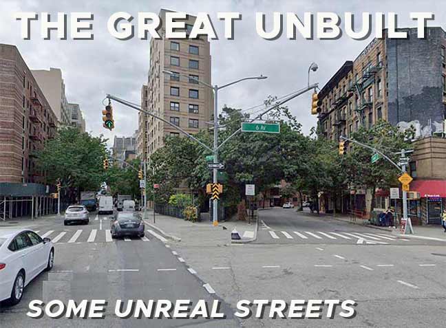
There was also a curious addendum to LOMEX, the addition of a new street in the Greenwich Village area, Verrazano Street, named for Italian explorer Giovanni da Verrazzano; the second “z” was added in the 2010s. The street would have extended West Houston a couple of blocks west to 7th Avenue South, as shown here.
|
|
|
|
|

Had Verrazano Street been constructed, it would have eliminated the building in the center of the photo and other properties behind it. Currently, westbound traffic on West Houston can choose to continue west on Houston (left) or north on Bedford (right).
I am unsure why traffic engineers thought that creating an eastbound route from 7th Avenue South to 6th Avenue at Houston would have facilitated LOMEX traffic, as the expressway was penciled to run above Broome. (Comments, as always, are open.)

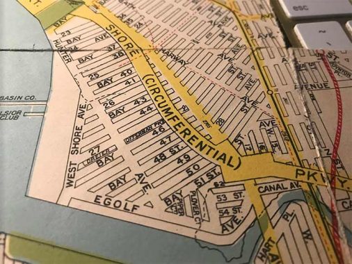
Forgive the distortion; I took an IPhone shot instead of scanning in a bout of laziness. From the 1920s all the way to the 1960s, the west shore of Bensonhurst had a series of mapped streets that extended the numbered Bay streets and numbered avenues all the way west to the Narrows. There were north-south avenues on the maps, Hunter, West Shore and the curiously-named Egolf; I imagine the name commemorated a property owner.
Update: I was tipped that the name Egolf goes back to 1888, as an Edward Egolf applied for a land grant in the area.
This Geographia map was produced in 1938 and the Belt Parkway, opened in 1940, was under construction. It would have cut off any properties constructed between it and the water and so, development in this area was limited. The area is fairly inaccessible past the Belt Parkway, as only 26th Avenue connects with the other side.

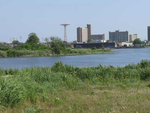
Today, this proposed neighborhood is occupied by Calvert Vaux Park. Its story begins in 1933, when the Dreier-Offerman home for unwed girls closed its doors and donated part of its holdings to the city. Over the years NYC Parks acquired more surrounding land from the city, including 72 acres of landfill built from the excavations done for the Verrazano-Narrows Bridge project. Through the decades Dreier-Offerman Park remained mostly undeveloped except for a couple of baseball and soccer fields. By 2011, the park, renamed in 2004 for Calvert Vaux (1824-1895), one of the developers, along with Frederick Law Olmsted, of Central and Prospect Parks, received new soccer fields and much of the grounds were cleaned up, with new walkways and signage pointing out the flora and fauna found along the park’s border with Coney Island Creek. Vaux (pronounced “vawks”), a Brooklyn resident, was found drowned in Gravesend Bay in 1895.
Since only Robert Moses and I could spell “Circumferential,” the name of the parkway is now Shore Parkway, informally called the Belt Parkway because it combines with Laurelton and Cross Island Parkways to form a “belt” along south and east NYC.
The Dreier-Offerman name hasn’t disappeared, though. It was bestowed to a playground at Cropsey Avenue and and Bay 46th Street.

As far as the three proposed avenues, Hunter, West Shore and Egolf, only a dead-end piece of one exists: Hunter Avenue at Bay 44th. The street is home to two schools for children with special needs, The Block Institute and the Brooklyn Hebrew School for Special Children.

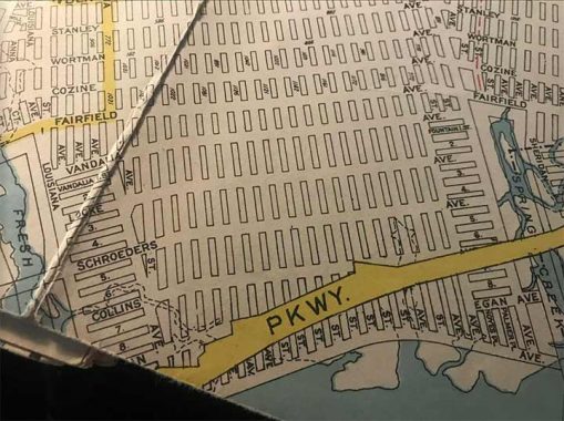

Another outlying section of Brooklyn that had mapped, but mostly unbuilt streets, was the south end of East New York. South of Stanley Avenue this land was mostly unoccupied till the 1950s; Cozine and Flatlands Avenues were extended east and cross streets were extended south, but none got much further south than Flatlands. When I bicycled Brooklyn I used Cozine, which was mostly warehouses and industrial buildings, to get from Bay Ridge into Queens rather than cycle through the tougher neighborhood to its north. Fairfield Avenue was dropped and Flatlands Avenue simply continued east.

Mapped streets included Fairfield (an extension of Flatlands), Vandalia, Locke, Schroeders and Collins. When Starrett City was built in the early 1970s on the west side of Hendrix Creek, Vandalia and Schroeders were built as east-west cross streets. Meanwhile, the Gateway Mall/Gateway Center megamall, and accompanying Gateway Estates apartments, were built from 2002 to 2014. The street layout also incorporated some of these old names, with the construction of Locke Street, Vandalia Avenue and Schroeders Avenue. I recall 1960s maps adding an Egans Avenue, and Egan Street, shown above.
There are few regions of Brooklyn in which I have not walked, and the now well-established Gateway Estates is one of them. Street trees have reached maturity and the street signs are sun-bleached, a sign they’ve been there awhile.



In what is considered to be part of Greenridge, Staten Island, developers had their eyes on a large tract between Woodrow and Arthur Kill Roads and Arden Avenue; for many years, the only substantial item in the area was St. Michael’s Home for Children, an orphanage established by the Presentation Sisters of St. Michael’s Church in Manhattan in 1884 until its closure in 1978. The grounds later hosted St. John Neumann Catholic Church until it was combined with the parish of St. Thomas on Amboy Road. Only a small cemetery hosting the remains of 80 of the Presentation Sisters remains from the orphanage.
After the 1980s developers gave up on the area and the area, still in its natural site, was ceded to the Parks Department in 1993 and is now called Arden Heights Woods. There are hiking and nature trails that I should visit someday.
Looking at the 1960s map, when developers hashed out a street grid, some fanciful names were conceived, such as Cilia Street and Itchia Street (I’m reminded of the Itchy and Scratchy cartoon characters on The Simpsons). Whoever conceived of these names is probably no longer with us and is unable to explain them.

Lastly for today, I’ll refer you to the same Hagstrom map this time showing Tottenville. When I began riding buses out to Tottenville in the early 70s, I discovered that most of the streets in between Amboy Road and Hylan Boulevard were largely unbuilt and the area was still woods. And, if you walk around Tottenville today, the older and more beautiful homes are found north of Amboy Road.
Today, though, I’ll talk about that gray stripe along the waterfront. Robert Moses had many dreams of moving traffic in Staten Island, but Shore Front Parkway was never constructed; consulting Vanshnookenraggen again, we see that Shore Front Parkway was supposed to branch from Korean War Veterans Parkway and run straight through Wolfe’s Pond Park before turning west at the waterfront and running as far as the end of Hylan Boulevard west of the historic Conference House. Happily for Wolfe’s Pond parkgoers, it was never constructed. Lengthy stretches of the KWV and Willowbrook (Martin Luther KIng) Expressway never happened either, saving hundreds of natural acres.
More to come…soon enough.
As always, “comment…as you see fit.” I earn a small payment when you click on any ad on the site.
6/18/23

10 comments
I’m rather sorry Egolf and Itchia weren’t built, because, well, those cool names.
Looking at Itchia St, I can’t imagine all of that stuff in between. I used to live at 39 Dover Green in the late 80s in that area called Village Greens west of Arden Ave. Did those streets on the west side ever look like that? And I remember the east side of Arden Ave being all woods. If it wasn’t built as planned, why not? Especially the west side since that did get developed, albeit into something you dont see a lot in NYC, circular streets that are like a townhouse subdivision.
Those streets were never built
Weirdly enough, “Itchia” is my Hungarian-born great-grandmother’s maiden name! Although she immigrated to the US in late 1800’s, the family was never in Staten Island.
https://www.bing.com/videos/riverview/relatedvideo?&q=Cat+Yawn&&mid=EBE5A7B8C1B18235D333EBE5A7B8C1B18235D333&&FORM=VRDGAR
“Itchia” looks like a misspelled anagram of “Ithaca,” and “Egolf” looks like some sort of trademark name for VR golf.
I find it strange to have a Verrazano Street planned for Manhattan despite not being anywhere near the actual bridge itself.
Flushing Avenue: “hold my beer”
Then again, there is a Manhattan Avenue in the Greenpoint neighborhood of Brooklyn for some reason.
It wouldn not have been necessarily named for the bridge but for the explorer himself.