In the early 1920s, in addition to assigning the majority of streets numbers and creating a unique hyphenated house numbering method, the Queens Topographical Bureau also designated several major routes as “Boulevards.” Thus Vernon Avenue became Vernon Boulevard, Farmers Avenue became Farmers Boulevard, and so on. Jackson Avenue and Broadway were combined to create Northern Boulevard, which as also taken over Route 25A, North Hempstead Turnpike, in Nassau County (despite it running through the entire Town of North Hempstead). In 2022, I posted an item about Queens’ smallest Boulevards. But I forgot one. I can forgive myself because it’s long out of use and in the far south of Queens.


In the neighborhood of Neponsit, just east of the Riis Park complex, the streets are numbered beginning with Beach 149th and get smaller as you go east, all the way down to Beach 2nd in Atlantic Beach, a block east of the undefended Queens-Nassau border. There are additional Beach streets to the west, as many Breezy Point Streets are in the Beach 200s. “Neponsit” is from a Munsee Native American word meaning “place between the waters.” The Munsee language also gave NYC “Rockaway” and “Canarsie.”
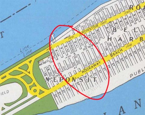
However, a different tribe named a former street in Neponsit. The name Adirondack, for the mountains in northeast NY State, is derived from an Iroquois word meaning “eater of tree bark,” a derisive term bestowed by them upon a neighboring Algonquin tribe. If we look at maps from the early to mid-20th Century, like this Hagstrom from 1949, Adirondack Boulevard is substituted for Beach 142nd Street.
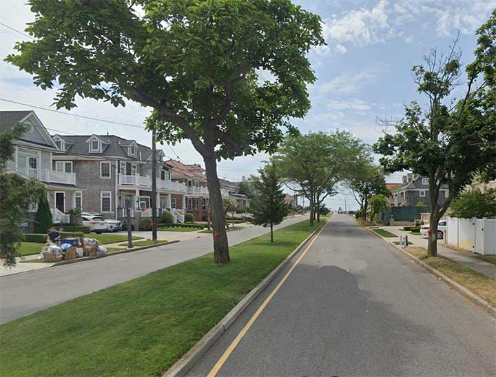
If you take a look at the street, it’s wider than the rest, with a center median. My guess is that the real estate company that developed this neck of Neponsit made the street a bit wider and the homes somewhat more expensive, and gave the street some importance by assigning it as a “boulevard”. By 1975, when I started bicycling down into these parts, it was plain old “Beach 142nd” and all trace of its tenure as Adirondack Boulevard was gone.
As always, “comment…as you see fit.” I earn a small payment when you click on any ad on the site. Take a look at the new JOBS link in the red toolbar at the top of the page on the desktop version, as I also get a small payment when you view a job via that link.
9/4/23


3 comments
What a shame the city LIED when they changed all the parking signs to NO STANDING after a heat wave that brought thousands to Riis. The crowd spilled over to Neponsit and visitors were all over, even on lawns. All of a sudden the city said that since the beach block was a dead end block, the fire trucks and engines must have trouble turning around. LIE!!! The signs were always NO PARKING ANYTIME which meant you could dropped people off at the beach and then go look for parking. My Dad was the LT. in Engine 329 at the time and said he NEVER had trouble turning anything around. If that were true ALL dead end blocks in NYC should have NO STANDING signs and they don’t. Hmmmmm!!! Why doesn’t Neponsit or Belle Harbor have a boardwalk that expends all the way to Riis????? You all know why. Sad.
“In the neighborhood of Neponsit, just east of the Riis Park complex, the streets are numbered beginning with Beach 149th and get smaller as you go east, all the way down to Beach 2nd in Atlantic Beach, a block east of the undefended Queens-Nassau border.”
Which begs the question: What happened to Beach 1st? (And a side note: I’m amazed that planners can ignore water, continue to plot streets as if that barrier never existed, and determine with certainty, “Oh, 115 Avenue should go here,” as in that map.)
Reflecting on the question on “where is Beach 1st. St.” If the street numbers were assigned in the 1920’s, the Atlantic Beach Bridge wasn’t built until 1950. The foot of the bridge is probably subsumed the spot where Beach 1st would go.