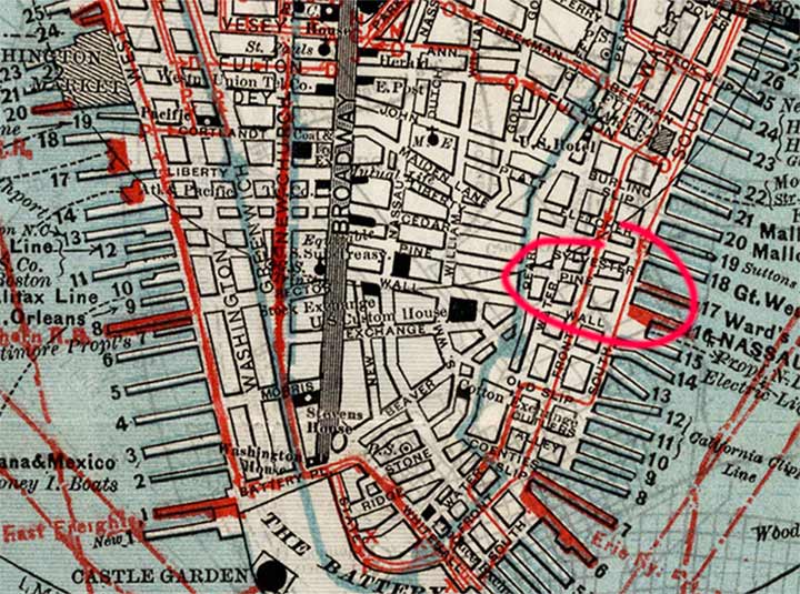
HERE’S part of a wonderfully detailed Edsall map of lower Manhattan from 1880. I’m sure I’ll return to it again and again for FNY posts; just look at how busy the waterfront was in that era. Today, though, I want to concentrate on one entry on the map that mystified me at first.
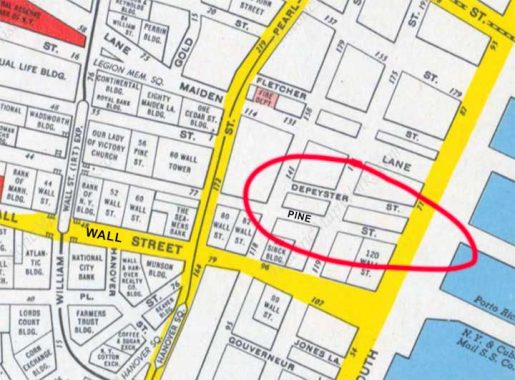
I have circled a short, two block street just north of Pine between Water and South Streets, called “Sylvester Street.” I had memorized all the streets of lower Manhattan and had never run across a Sylvester Street. I consulted my two go-to defunct Manhattan street guides…the street index of Kenneth Dunshee’s “As You Pass By,” ostensibly a book about lower Manhattan’s firefighting brigades before the FDNY, but also contains detailed maps and a list of hundreds of Manhattan streets that no longer exist. No Sylvester.
I then attempted to consult Gil Tauber’s site listing defunct streets, oldstreets.com. Nothing doing. That site has been down for a couple of weeks at least and I hope Gil hasn’t allowed the domain to expire.

Curious about what became of Sylvester Street, I consulted a Hagstrom of lower Manhattan from the mid-20th Century and it dawned on me that I had my answer. What is shown as Sylvester by Edsall is actually DePeyster Street. In 1880, the mapmaker likely heard what street should go there by voice. This was the dawn of telephony, with the 1876 invention by Alexander Bell and Antonio Meucci (who was unable to afford a patent). The mapmaker likely misheard “DePeyster” as “Sylvester!” Ain’t that the cat’s meow.
The street was named for Abraham DePeyster (1657-1728) aDutch Colonial 17th-Century New Amsterdam mayor; a seated statue of the Dutchman can be found at Centre and Worth, near Foley Square.
No trace of Sylvester, er, DePeyster exists today; it was demapped around 1970 and a pair of modern office buildings now sit in its old roadbed. The Municipal Archives has a few tax photos of this former street.
As always, “comment…as you see fit.” I earn a small payment when you click on any ad on the site. Take a look at the new JOBS link in the red toolbar at the top of the page on the desktop version, as I also get a small payment when you view a job via that link.
12/18/23


9 comments
Might it have been one of those “intentional” mistakes that mapmakers used in their maps to detect copyright infringement?
As I understand it, most copyright traps involved inserting very small nonexistent streets in out-of-the-way areas, which wouldn’t confuse anyone or be easily spotted. Changing the name of a street in a very busy area would be too obvious and could confuse people.
My first thought as well.
I added wrong streets to maps (to catch copyright infringement) – would never have inserted anything but a dead end – would never have inserted anything that REMOVED correct information.
…I think I can tell which Jonathan this is …
I’m with you. Gil Tauber’s Oldstreets.com is precious to NYC historians. Come back Oldstreets.com!
And I guess with call rates being what they were, they decided not to check by having someone verbally spell out the street?
They don’t even rhyme. DePeyster is pronounced “duh- PIE-ster” I would think.
The mid-50s Hagstrom Map shows the old 3rd Avenue Elevated on Pearl Street. That stretch of the old El, between South Ferry and Chatham Square, closed on December 222, 1950, so the map is exactly mid-20th century. Good find.