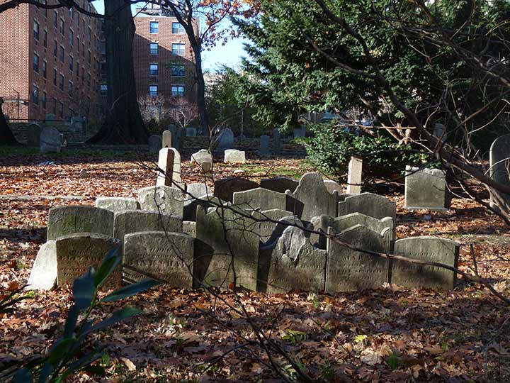
OLD West Farms Soldiers Cemetery, on Bryant Avenue and East 180th Street, is a designated Bronx landmark and has occupied this space since 1815. There are just 40 soldiers buried here in a plot that can accommodate more interments. The first soldier buried here was Sam Adams (not THE Sam Adams) a veteran of the War of 1812; the last, Valerino Tulosa, fought in World War I. The cemetery was founded by John Butler and the Butler family retained possession until 1953. Since then, NYC has been doing a middling job of maintaining it.
The stones seen here likely do not mark specific plots. Rather, they were likely knocked over by the local youth and were simply placed upright in a bunch, like this. Someone will have to find a burial plot map and put them where they belong.
The neighborhood of West Farms, and West Farms Road, hint at the Bronx’s rural past (as does Farmers Boulevard in southeast Queens). They were named during the colonial era, as West Farms is west of the Bronx River, a waterway that once divided New York County from Westchester County until NYC annexed all of the Bronx.
West Farms Road is one of the Bronx’s oldest roads going back to the colonial era. It runs from the intersection of Westchester Avenue and Southern Boulevard and runs in a curving, undulating fashion along the Bronx River for part of its route to Boston Road and East Tremont Avenue in the West Farms neighborhood. According to this 1901 map, it once extended east to Westchester Square, but that section became a part of East Tremont Avenue. The curving route may correspond to bends in the Bronx River that have since been straightened.
In recent years, West Farms Road received an upgrade as it is the westernmost lane of the new Sheridan Boulevard, a former expressway that was “reimagined” as an at-grade boulevard resembling Roosevelt Boulevard in Philly. It was given a bicycle lane and several grade crossings with stoplights allowing pedestrians to cross it to get to Starlight Park on its east side.
As always, “comment…as you see fit.” I earn a small payment when you click on any ad on the site. Take a look at the new JOBS link in the red toolbar at the top of the page on the desktop version, as I also get a small payment when you view a job via that link.
8/5/24


4 comments
It would be fantastic if that 1901 map had street view.
How do you know for sure youth were responsible for knocking down the gravestones?
A reasonable assumption.
When I was a kid in Whitestone, West Farms Square was just the mysterious and somewhat unlikely destination of what I considered our “local” bus, the Q44.
It was many years before I finally rode that bus to its last stop and discovered it was not the rural outpost I’d been expecting!