

ASTORIA Village has suffered greatly from building speculators with large sums of cash in hand. Numerous important houses have been demolished, only to be replaced with large, boxy multi-family dwellings. The need to save what remains is crucial – as a memory of the Village and a reminder of the importance of preserving districts before its too late. However, it’s been a losing battle since I first visited it in the 1990s.
Astoria dates to the mid-1600s, when William Hallett received a grant for the area surrounding what is now Hallett’s Cove from Peter Stuyvesant. The oldest structures in the region date to the mid-1800s, after fur merchant Stephen Ailing Halsey had incorporated the village in 1839. Astoria was named for a man who apparently never set foot in it: a bitter battle for naming the village was finally won by supporters and friends of entrepreneur and real estate tycoon John Jacob Astor (1763-1848). Astor had become the wealthiest man in America by 1840 with a net worth of over $40 million.
Astoria Village is centered at 21st Street, Astoria Boulevard and Newtown Road. West of here, the streets seem more timeless, with old churches, narrow sidewalks and hidden cemeteries, while east of here, things seem more conventionally Queens-like.
I have touched on but never devoted a page to Welling Court, which belongs to the small club of L-shaped streets that run in two different directions with a dogleg in the middle. Perhaps the most prominent member of the club is Commerce Street in Greenwich Village. Welling Court runs from Main Avenue south and east to12th Street. Welling and Main Avenue alone follow Astoria Village’s original 17th-Century street plan.
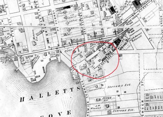
Here’s a detail from an 1873 map of south Astoria Village. The area has a complicated street layout that conforms to ox and horse cart paths on the Hallett farm. That layout remains intact today. I have circled in red the path of Welling Court, then called St. George’s Place, after Astoria Village’s most prominent church; church and graveyard remain intact today. Note that the dogleg section that meets today’s Main Avenue was originally called Green Oak Street, or just “Green Oak.” On the map, you see a Welling Street, but that is now part of 12th Street.
Main Avenue and Welling Court defined the outline of the Hallett vegetable garden. The Hallett barn was at the end of Welling Court. About 1837, the ancient Hallet farm was cut up into lots. The property was divided into 100/200 ft plots that sold for $150 each.
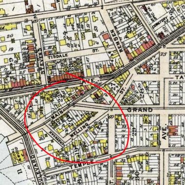
By 1909, this area was a little less empty. But you can see that many individual plots are still unoccupied, with frame houses marked by yellow boxes.
I asked Bob Singleton, proprietor of the Greater Astoria Historical Society (of which I’m a board member) to provide some notes regarding this little known but historic thoroughfare. He provided his own notes as well as some by Queens and the Long Island Rail Road’s preeminent researcher Vincent Seyfried (1918-2012)…
William Hallett and his two sons worked to improve the farm at Hallett’s Cove. By 1678 they had 48 acres under cultivation and owned two yoke of oxen, 7 horses and colts, 23 cattle and 34 sheep. South of the present Astoria Blvd. and on the shore, William Hallett had built a house for his son, William Jr. and his wife. Between the gardens of the two houses ran a broad lane which, turning south and passing around the garden of William Hallett Sr., ran a short distance to his barns and then resumed its easterly direction, extending for some distance along the north side of his young orchard. This lane is the present Welling Street just south of Astoria Boulevard and this is the reason for the curious right-angle bend in it.
At the east end of Welling Street began the wood path that developed into today’s Newtown Avenue; at its west end and upon the shore there was a small dock from whence the Halletts rowed their market boat to lower Manhattan. South of the farm house and orchard lay the high ground of Sunswick Terrace along Vernon Avenue and below that, the low land and meadows down to Sunswick Creek at Broadway. The meadows were divided for drainage purposes by a main ditch probably along the present 21st Street. To keep the salt water out at high tide, the Halletts as early as 1679 built a dam across the mouth of Sunswick Creek which continued to be maintained for almost 200 years.
As William Hallett Sr. grew older, he began to gradually divide the great Hallett tract between his two sons, William Jr. and Samuel. Everything north of Welling Street and Astoria Blvd. he retained for himself and the younger son, Samuel. {Vincent Seyfried]
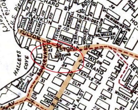
This detail from a 1922 Hagstrom map shows Welling Court but the scale isn’t close enough to provide detail. It is mislabeled as “Wheeling Street” but subsequent editions fixed the error. Astoria was still holding firm to its old street names in 1922, but that would all change later in the decade.
The original land route to Hallets Cove was stymied by marsh – the area along the East River had Welling Creek running from Queens Plaza to Hallets Cove, and Trains Meadow running from Northern Boulevard up to North Beach. The only land route which was connected to the rest of Long Island was a beaver dam straddling Northern Boulevard at Woodside Ave, a colonial road to Newtown, which led to the township seat in Elmhurst. Heading west, to the Hallet Farm at Hell Gate, was Newtown Avenue and Newtown Road.
At 21st Street the road made a bend to Hallets Cove where it continued, under names as Astoria Blvd and Main Ave to the ferry that connected Long Island to Manhattan.
From about 14th Street, a lane split off to the south and under the name of 12th Street and then Welling Court, made a bend back to the main road at the ferry. The barn was at the end of Welling, where it turned northward. Across the road at Two Coves Garden would be the approximate location of the farmhouse. In the elongated triangle between 14th Street and Welling was a series of special plots – the orchard, the garden, and the family cemetery.
During the American Revolution, this was a key location for the occupying British troops who maintained a garrison at the Hell Gate, a battery of cannon at the waterfront, and control over ferry traffic between Manhattan and Long Island. The farm became an encampment for soldiers, and it was likely the time that a series of buildings were erected to satisfy the needs of the family. [Bob Singleton]
An interesting building, 11-45 Welling Court, stands apart from the other buildings in size and location and very well might have been the command headquarters for the British Garrison. Across from the building we know of at least one burial of a British officer at 11-13 30th Road (an uninscribed gravestone may have been recovered a few decades ago). If the Hallets were pro-British or held as quiet captives, when the Brits left New York they temporarily lost some of their lands (such as Welling Court) to the pro-American faction (General Ebenezer Stevens built his Mansion on the next block on 30th Road). The Hallets later returned and ran a successful funeral home until the early 20th century and still live on Long Island..
The Welling Family lived in the area as early as the 18th century and likely gave their name to the lane when it was being developed in the early 19th century.
As to the buildings on Welling Court, they were likely houses or stores for the traffic that came off the ferry until the ferry moved to the end of Astoria Blvd. I personally talked to a middle-aged man who, as a child, dug up an early 19th coin in the dirt of a house he lived in at the end of Welling Ct. He had wanted to photo-document the building before it was torn down but did not have the chance. [Bob Singleton]


On the north side of Welling Court is a group of homes that were originally workers’ cottages built about 1850 by Robert Blackwell (Roosevelt Island’s old name, Blackwell’s Island, came from his family, who owned acres in today’s Ravenswood and on the island.) Here you see a couple of images from 1940 and one from 2024.


Here you can see some of the buildings on the south side of Welling Court. Most are still standing, but most of the detail has been stripped away since 1940, as insulation and siding has been added. We are quite near the East River at this juncture.


The basic outlines of this house, seen in 1940 and 2024, are still there, but the building is now surfaced with stucco.
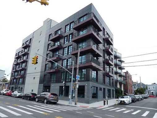


I happened by this grouping of small, peaked-roof houses at Welling Court and Main Avenue in 2016. I had good timing, because they were torn down the next year and this new structure went up in its place. Some souces say that those small houses were built during the colonial era.
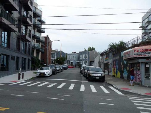
Welling Court, looking south from Main Avenue. This is the short section originally called “Green Oak.”


The west side of Welling Court south of Main Avenue featured some partly done street art as well as empty lots protected by barbed wire. You can see the rear end of a newer residential building on Vernon Boulevard.

Speaking of which, Vernon Boulevard was originally a tolled plank road that went south across Newtown Creek to Greenpoint. The Department of Transportation has marked its northern end at Welling Court. North of this spot, the road is 8th Street.


Here’s a sampler of colorful murals I found in 2016 painted by artists who have congregated on Welling Court as part of the Welling Court Murals Project...


Though the WCMP is still going strong, I found the offerings in 2024 somewhat more lackluster.


I actually found the stickers affixed to the rusted lamppost at 30th Avenue and Welling Court more interesting!
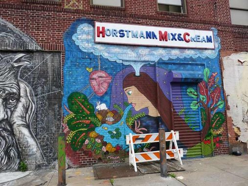
Finally, I wanted to see if this colorful plastic letter sign for Horstmann Mix & Cream I last photographed in 2016 on 12th Street and Welling Court was still in place. Alas, the building was also torn down in 2017, and the lot remains empty. The sign? Who knows what became of it.
As always, “comment…as you see fit.” I earn a small payment when you click on any ad on the site. Take a look at the new JOBS link in the red toolbar at the top of the page on the desktop version, as I also get a small payment when you view a job via that link.
8/18/24
6 comments
Thanks Kevin! Now their past (or some shape of it) will be immortalized on your blog. As to the public, if you lived in those houses that were recently torn down, of know of someone who did, or were part of the construction crew that tore them down, we would welcome any photos or event a rendering in pen and ink of their inside layout. In the outside chance that you have any wood from these buildings it would be invaluable as you can now determine when a tree was cut down by its growth rings. Bob Singleton GAHS
I live in this area. Every year I try to take photos of all the murals since they get painted over and lost forever. I have a whole bunch. 2016, which you captured here, was a particularly good year.
I volunteer at the Astoria library nearby, it may be cool to assemble a display there , using photos and text.
Great photos! We can thank the Vallones and multiple Queens Borough Presidents and the Manhattan and Brooklyn focused Landmarks Commission for refusing to landmark Astoria Village in 80s and 90s.
Exactly!
I am the middle aged guy who as a child dug up many 18th and 19th century coins in the front yard of my family home of 11-01 Welling Court. The home has since been demolished along with the surrounding four properties to produce one gigantic building. Most of the Victorian era homes have been razed since the late 70’s and there’s not much left to preserve. Homeowners fought land marking the area and deep pocketed developers took advantage of the zoning and lax local government.