
By SERGEY KADINSKY
Forgotten NY correspondent
In the fall of 2024, a new road and waterfront park opened in Long Island City, taking its name from the neighborhood’s industrial past. With the East River shoreline lined by post-millennial parkland and residential towers, this transformation is now spreading to its tributary Newtown Creek.
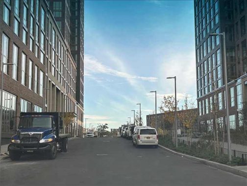
On the map, Malt Drive is a continuation of 55th Avenue on the borough-wide grid but having been built by a private developer its name makes it stand out on the map. Upon a closer look, it is evident that Malt Drive is a private street that is open to the public. In the same manner as the streets of Forest Hills Gardens and Fieldston, the public can walk and drive here, but no parking allowed on the penalty of towing! The topography of this block is raised, with storm surges in mind.
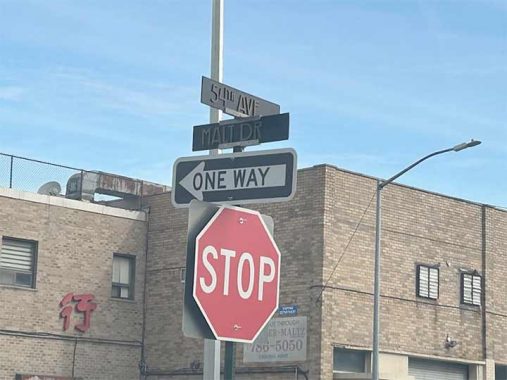
Additionally, this street has custom-designed signs with a unique font. If you know the name of this font, leave it in the comments. Functionally, the standard green signs with white letters are more visible than this attempt at branding.
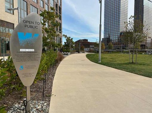
On the waterfront side of these towers is Malt Drive Park, which has a watery W logo rather than the official leaf of NYC Parks. This logo indicates a privately-owned waterfront park designed in coordination with the Department of City Planning. Such parks are open to the public, similar in practice to the POPS that are common throughout Manhattan.
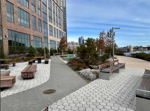
Designed by the architecture firm SCAPE, the paving in this park is eclectic, creating a mosaic for dwellers of the high-rise and a sense of exploration for pedestrians. The park contains theme zones, such as a dog run, playground, picnic plaza, and lawn.
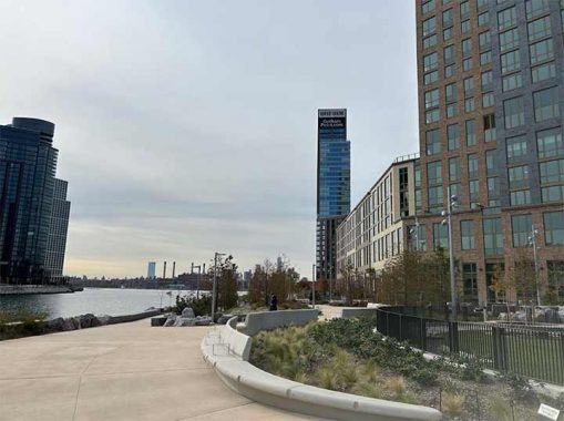
Looking at the confluence of Newtown Creek and East River, the tallest tower here is Gotham Point, with unobstructed views of Brooklyn and Manhattan. Its name disappoints me as a historian. The Dutch called this confluence Dominie’s Hoek and their English successors ascribed Hunter’s Point to this tip, but among developers there’s a Columbus mentality to rename places with the sense of discovery to the disregard of native sensibilities. On the other hand, Gotham is a classy name and standing on that rooftop deck with views of the sunset behind Manhattan brings out the Bruce Wayne in anyone.
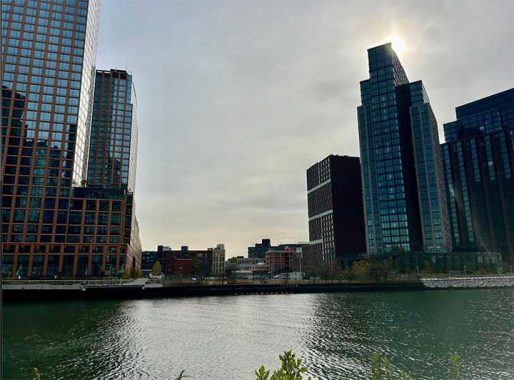
Looking across Newtown Creek, there is a gap between Greenpoint’s post-millennial high-rises. A former parking lot for buses, this parcel was designated for parkland as Box Street Park. At the time of my visit, construction on this 3-acre park had not yet begun.
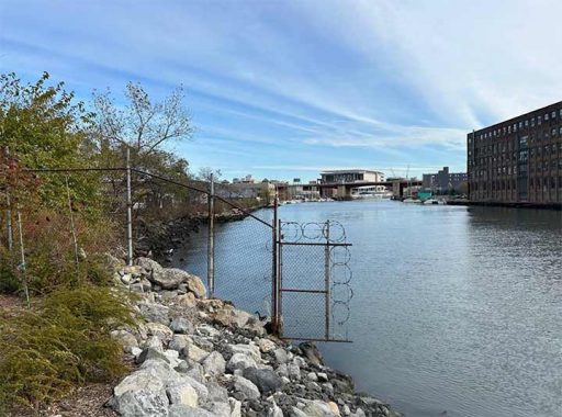
Looking upstream on Newtown Creek, one can imagine the entirety of its course lined with parks and residential towers, kayaks and canoes on this long-troubled waterway, and perhaps an expansion of NYC Ferry to Maspeth and Bushwick. Before 1954, Greenpoint’s Manhattan Avenue and LIC’s Vernon Boulevard were connected by a bridge. What’s old is new, as there is a proposal for a floating pedestrian drawbridge to reconnect them.
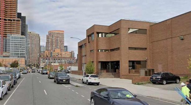
Prior to the building of Malt Drive, this site had a City Harvest distribution warehouse. The malt name hints to an earlier use of this site for beer distribution. In the early 20th century, maps show Hunter’s Point hosting the New York Sugar Refinery. With Domino Park in Brooklyn capitalizing on its sugary past, Malt Drive’s builders looked to beer as its historic identifier.
With the decline in manufacturing and railroads, the tip of Hunters Point became vacant. It was rezoned for residential use with new streets drawn on its map. In 1995, a circular road was assigned to Hunters Point. It was modified in 2010 with Center Boulevard given a curvy route along the shoreline, reminiscent of Manhattan’s Riverside Drive.
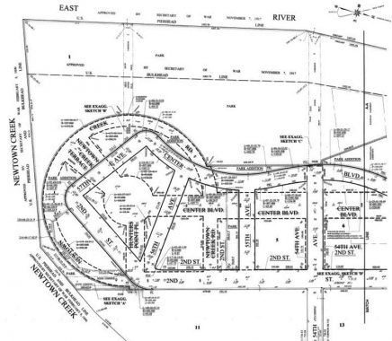
As manufacturing and railroads declined, the tip of Hunters Point became vacant. It was rezoned for residential use with new streets drawn on its map. In 1995, a circular road was assigned to Hunters Point. It was modified in 2010 with Center Boulevard given a curvy route along the shoreline, reminiscent of Manhattan’s Riverside Drive.
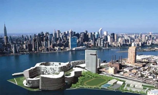
Situated across the East River from the United Nations headquarters, the tip was proposed for its own international campus: the Olympic Village as part of the city’s candidate bid for the 2012 summer games. Renderings of the final design show curvy buildings and lawns akin to Chatham Green apartments of lower Manhattan.
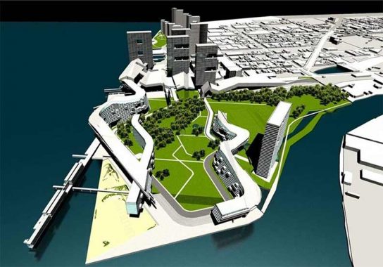
Transportation to many of the Olympic venues in the city would have been by boat from Hunters Point. London was given the 2012 games and its bid was also related to water, with venues situated along the River Thames. The 2024 games in Paris had their opening ceremony on the Seine River. Although New York did not get the 2012 games, it set the trend and inspired the NYC Ferry system which has routes and stops on the East River.
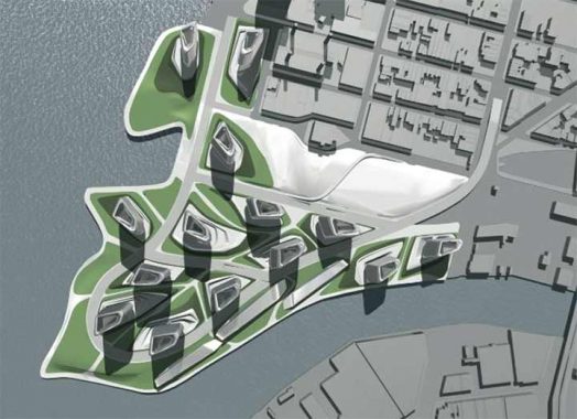
The winning design for the never-built village was submitted by the firm Morphosis. Among the architects who submitted designs was Zaha Hadid, whose plan looked like a leaf from above. The Iraq-born designer had many proposals for buildings in this city, all with a sculptural look that defined her works. Only one got built, 520 West 28th Street, situated next to the High Line.
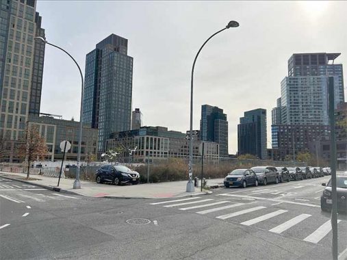
Block by block, the western frontier of Queens is filling up with towers to satisfy demand for housing. Most of these units are too expensive for the middle class and there are affordable lottery units for the fortunate few. What accounts for the high rents? Certainly the location and cost of building, but there are also amenities such as doormen, play rooms, work rooms, exercise rooms, pool, and rooftop deck. Most of us can live without these luxuries, we need only a roof over our heads, with a kitchen, bathroom, at least one bedroom, and living room.
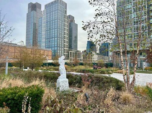
Not all parcels are destined for density. On the space intended for 53rd Avenue is a park with sculptures with the LIRR ventilation building behind it. Under this park are the East River Tunnels that serve Amtrak, LIRR, and NJ Transit. Completed in 1910 to connect with Penn Station, these tunnels resulted in the decline of the Long Island City terminal.
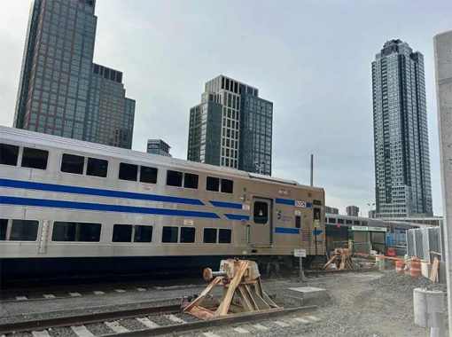
The terminal today deposits passengers in its railyard. There is no building with a waiting room, and few travelers use this station. Used for storing diesel trains, it offers a direct ride to Patchogue and Port Jefferson, among other points on Long Island. With a growing population, perhaps there’s a case for expanding service here and reviving stations on the Lower Montauk branch that were abandoned in 1998, but as history shows, it’s easier to abandon a train line and astronomically impossible to revive it.
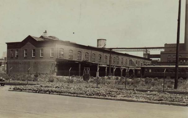
When city photographer Percy Loomis Sperr visited this station, it had a sizable headhouse and multiple platforms but it was long in decline. Once a transfer point between trains and Manhattan-bound ferries, it lost most of its foot traffic to Penn Station. In 1936, the last ferry departed from Hunters Point. The ferry to 34th Street/Kips Bay and other docks on the East River resumed service in 2017.
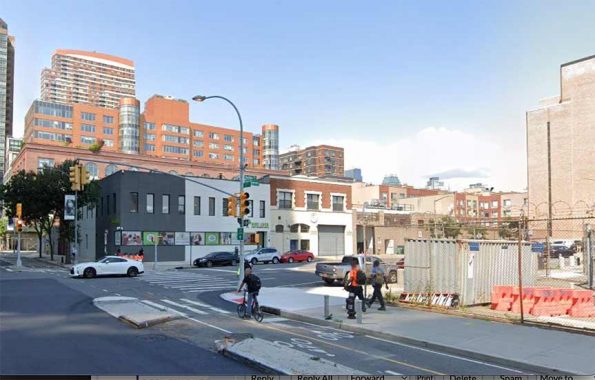
In the decades when train service was the leading form of transportation, nearly every station on the LIRR had a hotel next to it. Among those that stood to the present day, Forest Hills Inn became apartments and Homestead Hotel at the Kew Gardens station became a senior home.
At Borden Avenue and Second Street, Tony Miller’s Hotel served passengers between 1881 and 1919. Kevin recounts its history in his 2005 essay on the city’s oldest bars. Decline in ridership at the LIC terminal and the prohibition spelled the end of the hotel.
In 1978, restaurateur Anthony Mazzarella transformed this building into the Waterfront Crabhouse. It attracted a clientele of celebrities and curiosity seekers who admired the antique objects collected by the owner, making it feel like you’re eating seafood inside a museum. Kevin also admired the restaurant’s historic streetlight outside. After Mazzarella’s death in 2015, the restaurant closed. It is now a preschool that teaches Mandarin.
Looking north, behind the Waterfront Crabhouse stood the Pennsylvania Railroad’s massive powerhouse. The famed beaux arts firm McKim, Mead and White designed this structure and its defining presence on the waterfront inspired artist Georgia O’Keeffe. She used the building as a centerpiece in her 1928 precisionist painting of the East River. The building was vacant for a decade and used as a plumbing warehouse.
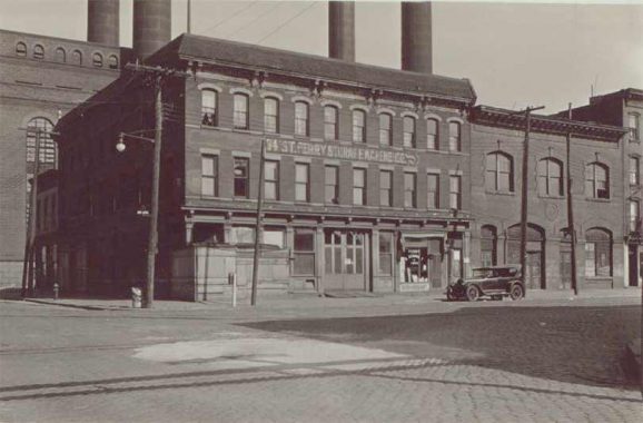
In 2006, architect Karl Fischer and interior designer Andres Escobar transformed the Powerhouse into condominiums. Sadly, its four signature smokestacks were removed in the redesign. When Sperr visited this corner, Miller’s Hotel was repurposed as a storage warehouse. Its neighbor with three windows has the look of an old firehouse. A good guess, but I learned that it used to be a trolley repair garage.
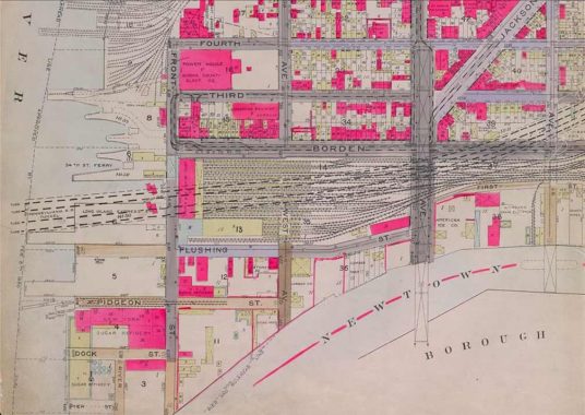
The Belcher-Hyde atlas from 1919 shows trolley tracks on Borden Avenue snaking behind this garage. At the time, Long Island City had its own numbered grid of streets that were absorbed in that year into the larger borough-wide grid.
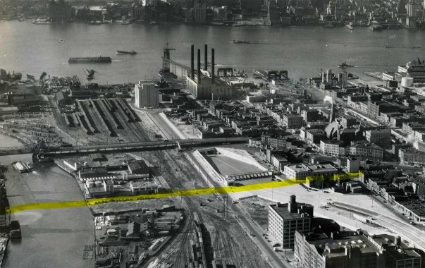
Sperr also took a photo of Borden Avenue looking east in 1936 in preparation for construction of the Queens-Midtown Tunnel. Most of the buildings on this block would be demolished to make room for the tunnel’s ventilation tower, which stands in the middle of this street. An aerial view from the archive of MTA Bridges & Tunnels shows the newly completed tunnel in 1940. The ventilation shaft’s proximity to the railroad powerhouse symbolizes two forms of transportation on Long Island, the railroad and the beginning of the Long Island Expressway. By 1972, this highway would reach its eastern end at Riverhead. The highlight here is the future path of Pulaski Bridge, which was completed in 1954.
Kevin and I have been to Hunters Point many times. There’s always something new to see here and something old to uncover. My first visit here was in 2010.
You can learn more about the history around Hunters Point by visiting each of the hyperlinks posted in the essay above.
Sergey Kadinsky is the author of Hidden Waters of New York City: A History and Guide to 101 Forgotten Lakes, Ponds, Creeks, and Streams in the Five Boroughs (2016, Countryman Press), adjunct history professor at Touro University and the webmaster of Hidden Waters Blog.
As always, “comment…as you see fit.” I earn a small payment when you click on any ad on the site. Take a look at the new JOBS link in the red toolbar at the top of the page on the desktop version, as I also get a small payment when you view a job via that link.
12/2/24


1 comment
“Block by block, the western frontier of Queens is filling up with towers to satisfy demand for housing. Most of these units are too expensive for the middle class and there are affordable lottery units for the fortunate few. What accounts for the high rents?”
It’s the citywide housing shortage. The amenities are a symptom, not a cause.