

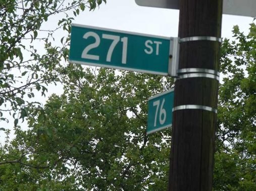
TODAY, I offer a shot of an ordinary residential Queens street just south of 76th Avenue in the shadow of the Long Island Jewish Medical Center, where I have visited patients, waited interminably in the emergency room, and had a hernia operation. (My heart operation was at St. Francis Hospital in Roslyn.) Why this street? It’s the highest numbered street in New York City, 271st, which runs 4 short blocks from 76th Avenue south to where 79th Avenue meets Langdale Street and the (so far) undefended border where Queens meets Nassau. Indeed, some of Queens’ numbered avenues such as 79th, 80th, 81st, briefly invade Nassau.
However: had Nassau County not been created in 1899, those numbered streets might just have reached much higher.
Long Island counties, beginning in the late 1600s, were Kings, Queens, and Suffolk. Six towns in Kings consolidated in the late 1800s to create the City of Brooklyn, which was annexed (residents voted to consolidate it) to Greater NYC in 1898. Queens’ history is a bit more complicated. Queens originally comprised western Queens (the towns of Newtown, Flushing, Jamaica and in 1870, Long Island City) and what is now Nassau (towns of Hempstead and Oyster Bay; North Hempstead was created in 1784). The eastern towns began agitating for “independence” from Queens County beginning in the 1830s, when a dilapidated courthouse in the Mineola area was to be replaced. Factions from the western and eastern parts of Queens vied for the new courthouse, which was ultimately built in Long Island City at the present Court Square in 1870. Differences, political and cultural, between the east and west ends of the vast county were accentuated during the debate. In the 1890s, proposals for Greater New York did not include Queens’ eastern towns.
When Greater New York was born on January 1, 1898, Queens’ four western towns were politically dissolved and western Queens became a borough. Queens’ 3 eastern towns remained extant. For one year, January 1, 1898-January 1, 1899, half of Queens County was in NYC, half was not. The eastern towns finally seceded to become Nassau County on 1/1/99. When Queens’ numbering system was gradually implemented beginning in the 1920s, it would have likely reached the Suffolk county line, had not Nassau County been created. 500th Street, anyone?
Check out the ForgottenBook, take a look at the gift shop. As always, “comment…as you see fit.” I earn a small payment when you click on any ad on the site.
3/12/25
6 comments
You forgot to mention that it crosses Union Turnpike
If you want to extend the grid then take a look here: https://extendny.com/
The Rockaway peninsula had to secede from Town of Hempstead in order to become part of Greater NYC. Unlike Long Island City vis-a-vis Newtown, the beach hamlets and villages did not become their own township before leaving Hempstead to join the rest of Western Queens in NYC
I did a quick google map search and discovered a SW 307th St. in Homestead, Florida, a Miami suburb. Miami’s grid street system extends far into its adjacent suburbs, and the flat terrain made it easy to continue numbered streets as long as possible.
Where I live now in southwestern Nassau County is about five miles from the Queens border, where the highest number is 262nd St. in Rosedale. My current house would probably be on 350th Street if the Queens numbers continued eastward well into Nassau.
The advantage to numbered streets is that it’s easy to find one’s way around.
Here’s what can happen to unincorporated areas when they border a larger incorporated entity:
https://santanvalley.com/san-tan-valley-area-information/san-tan-valley-news/queen-creek-to-annex-4-140-acres-of-san-tan-valley
This is why San Tan Valley, AZ is trying to incorporate (after it’s too late)
The original plans for Greater New York City included a strip of the Town of Hempstead. This would have placed (and for about a year did place) Inwood, Lawrence, Cedarhurst and parts of Valley Stream, Elmont and Floral Park into New York City. The Rockaway Peninsula was also included. Residents of the mainland portion objected to being included in NYC and in 1899 the city line was adjusted to roughly where it is today, with the Rockaways being the only part of Hempstead Township to remain in the City.
Had this area remained in NYC I’m not sure whether street numbering into these areas would have exceeded 271st Street or not, though it’s possible because Rosedale’s numbered streets go up to 262nd Street and Place. Also possible is that the “Beach” numbered streets may have commenced in Lawrence and not Far Rockaway, which would add about 25 or so to today’s numbers.