

No one is really celebrating it, but on the eve of the nation’s 249th anniversary, I’d like to mention another anniversary: the redrawing of the Brooklyn-Queens borderline separating present-day neighborhoods of Bushwick and Ridgewood. The original boundary was set at what is today Flushing and Onderdonk Avenues by what was called Arbitration Rock. From FNY’s page on the boundary marker:
Natural elements, like trees, rivers and mountains, were and are still used to delineate political boundaries. In the case of Kings and Queens Counties, rocks and boulders left by the passing of a glacier 100 centuries in the past were used–and astoundingly, three such boulders are still in existence. In the back yard of the Onderdonk House is a large rock surrounded by a picket fence. It is the official position of the Greater Ridgewood Historical Society that this is the historic “Arbitration Rock” used to delineate the border, along the Brooklyn-Newtown Turnpike, of the borders of the towns of Bushwick and Newtown, or today’s Brooklyn-Queens line. In 1769 a large stone was used by surveyor Peter Marschalk to designate the boundary, which had been in dispute. The story goes that the rock had been left underground when Onderdonk Avenue was extended in 1930, and when the avenue was re-graded in 2000 the rock was exposed. It was moved to the backyard of the Onderdonk House the following year. The GRHS has yet to provide documentation in proof.
Other historians, such as Greater Astoria Historical Society’s Bob Singleton, aver that a large rock at Varick Avenue just north of Flushing Avenue was the true marker, and other entities claim a large rock at Morgan Avenue and Rock Street (since removed) was the marker.

For centuries the Brooklyn-Queens county border ran on a diagonal straight line cutting through Bushwick and Ridgewood, separating what were then the towns of Bushwick and Newtown. (Hagstrom map, 1922)

In 1925, after both neighborhoods were well built up and the line was cutting across properties, it was redrawn to zig and zag along a number of streets; the border today runs mainly along Cypress and Wyckoff Avenues. (Hagstrom map, 1949).
To honor the centennial of the modern, undefended Queens-Brooklyn border in Bushwick and Ridgewood, I thought I’d show a few scenes using the magic of Google Street View and saving me a trip.

Between Greenpoint and Long Island City, Blissville and Maspeth, the line runs down Newtown Creek. At the creek’s end at Metropolitan Avenue, it crosses the Long Island RR Bushwick freight-only tracks and runs down this one-block segment of Seneca Avenue for one block between Randolph Street and Flushing Avenue.

After zagging a block west on Flushing Avenue, the line then zigs south for several blocks on Cypress Avenue. I wasn’t frequenting the area before the 2000s, so I’m wondering if color coded street signs, white in Queens, and black in Brooklyn, were used along the border. If you lived in the area, Comments are open.

The border turns south for a block on Menahan Street. On each side, house numbering is in the 400s. The Queens side (on the right) does not use the hyphens in the addresses typically used in Queens. In fact, many if not most Queens homes do not display the hyphen at all; it’s only used on written correspondence.
Long, long ago, Menahan Street was called Ralph Street and may have been named as a northern extension of Brooklyn’s Ralph Avenue, which extends south to Bergen Beach, with interruptions.
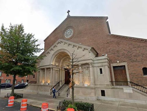
Ther border turns south again and runs three blocks along St. Nicholas Avenue from Menahan Street to Gates Avenue, passing St. Brigid’s Church. The parish is longstanding and was founded in 1887.
Streets in Ridgewood honor NYC’s Dutch past, with Onderdonk (colonial-era family), St. Nicholas (Dutch traditions originated the Santa Claus Christmas figure); Knickerbocker and Irving Avenues honor Washington Irving, whose stories are set in Dutch-era New York).

Turning south again, the line runs one block along Gates Avenue between St. Nicholas and Wyckoff Avenues. Gates Avenue is named for Revolutionary War General Horatio Gates (1727-1806), victor in the Battle of Saratoga who later had political problems with President George Washington.

The bulk of the Brooklyn-Queens border runs along the commercial spine of Wyckoff Avenue, between Gates Avenue and George Street. Named for another Dutch colonial family, it is seen here at the elevated M train station at Palmetto Street. In 1928 the BMT Canarsie Line was built in a tunnel under it. I have walked Wyckoff Avenue’s length on two occasions, in 2008 and 2016, so I may be due again.


Here’s where things get a bit wonky at the border. The borough line turns south at 1006 Wyckoff Avenue and, if you believe Open Street Map, it goes right through the building!
The line runs on its own “right of way” between Halsey and Eldert Streets (which dead ends off Wyckoff) before turning south again at Irving Avenue. An official document, though, places the line on Eldert Street proper. Interestingly that means the borough line rests on both Eldert Street and further south, Eldert Lane.
|
|
|
|
|
|

According to Open Street Map the line goes right through the entrance to this parking lot/loading dock of a food wholesaler on Irving Avenue.
Note: see Comments for a revision on this.

The south end of Irving Avenue at Moffat Street. The trees in the background are in Most Holy Trinity Cemetery. The borderline then runs through the Cemetery Belt along the glacial moraine, until headsing south along Eldert Lane and other streets to Jamaica Bay. In the City Line area, the line has also been rejiggered; it used to follow Spring Creek inland, before it was redirected into the sewer system and the line was changed to conform with a newly created street grid in the area known to Brooklynites as “The Hole,” where certain persons who ran afoul of other certain persons were deposited. I discussed that change in this 2023 FNY page.
Check out the ForgottenBook, take a look at the gift shop. As always, “comment…as you see fit.” I earn a small payment when you click on any ad on the site.
7/3/25
10 comments
Please do a before and after picture plus story on the midnight rose candy store!
I will go drink a $17 margarita at Nowadays to commemorate the
anniversary
“I’m wondering if color coded street signs, white in Queens, and black in Brooklyn, were used along the border.” I walked the whole border around May, 1985. The colored street signs were mostly correct. I do remember one corner where the cross streets had one sign correct and the other was not correct. A Queens sign on top and a Brooklyn sign for the cross street below. My walks along the Long Island/Queens border found no mistakes. Also along The Bronx and Westchester County. I do not remember any mistakes along the Marble Hill border between Manhattan and The Bronx. I did notoce that the phones were all “718” in Marble Hill.
Love it!
Don’t believe Open Street Map for the location of the county line between Wyckoff Avenue and Irving Avenue. The line is in the center of Eldert Street. Open Street Map is also wrong further east because the county line is on the east side of the railroad tracks, at the border with the Cemetery of the Evergreens; nor is it correct in showing the county line cutting through Most Holy Trinity Cemetery but instead the county line is the border between between Most Holy Trinity Cemetery and the Cemetery of the Evergreens (until it intersects the older county line defined by Arbitration Rock and heads southward).
Go to the source: Laws of 1925, chapter 627, section 2. Find that provision here: http://books.google.com/books?id=twGxAAAAIAAJ&pg=PA1041. This provision reads:
The boundary line between the counties of Kings and Queens is hereby in part changed, and when changed shall hereafter be located and described as follows: Commencing at a point formed by the intersection of the present line between Kings and Queens counties, where the same is intersected by the center line of Onderdonk avenue about the southerly line of Metropolitan avenue, running thence southeasterly along the center line of Onderdonk avenue to the center line of Seneca avenue; thence southerly along the center line of Seneca avenue to Purdy place; thence southeasterly along the center line of Purdy place to Flushing avenue; running thence southwesterly along the center line of Flushing avenue to the center line of Cypress avenue; thence southeasterly along the center line of Cypress avenue to the center line of Menahan street; thence southwesterly along the center line of Menahan street to the center line of Saint Nicholas avenue; thence southeasterly along the center line of Saint Nicholas avenue to the center line of Gates avenue; thence southwesterly along the center line of Gates avenue to the center line of Wyckoff avenue; thence southeasterly along the center line of Wyckoff avenue to the center line of Eldert street; thence southwesterly along the center line of Eldert street to the center line of Irving avenue and thence southeasterly along the center line of Irving avenue to the northwesterly line of the cemetery of the Evergreens and running thence southwesterly along the northwesterly line of the cemetery of the Evergreens to the northeasterly boundary line of the Trinity Roman Catholic cemetery, and running southeasterly and southwesterly along the boundary lines of the Trinity Roman Catholic cemetery to the point of intersection of such line with the present boundary line between Kings and Queens counties.
Other sections of the Brooklyn-Queens border are also not depicted correctly in Open Street Map. For example, the area of Highland Park that was being developed residential use was transferred from Queens County to Kings County effective April 28, 1915. See L. 1915, ch. 410, § 1. The boundary line was established on the north side of what is now the Jackie Robinson Parkway service road (then known as Vermont Avenue), not in the middle of the parkway itself as depicted by Open Street Map. The land north of the service road was then part of the Cemetery of the Evergreens, with the parkway itself constructed on cemetery land that had been condemned. The parkway would not open for another twenty years. Open Street Map also shows the county line in this area going through the middle of a building at 355 Highland Boulevard. Again, this is wrong, with the county line tracing the property line between Highland Park and the residential land. Prior to 1915 the county line continued southward from the Jackie Robinson Parkway service road along the same line defined by Arbitration Rock to Highland Boulevard, then eastward more or less along Highland Boulevard. Open Street Map is a volunteer effort and not always correct. While volunteers have made great efforts to provide details, they’re not always correct.
This should shed some light on the Eldest Street situation where a building is situated in both counties.
When the line was changed in 1925, the Eldest Street border ran through Wallace Field, a long forgotten baseball park. Since Wallace Park was expected to close, which occurred the following year, the assumption was made that this would enable the block to be opened for treffic. But this did not occur, or more correctly, only a small portion running into Wyckoff Avenue did. The rest of the block remained closed.
In 1977, an application was made under the newly enacted Uniform Land Use Review Process to enable a building to be constructed on the street bed. No one had a problem with this and the building straddling both counties was constructed.
For those who are interested, I posted a piece on the line change on my Facebook page, which also ran on the Bushwick Daily page.
I am curious why the straight border line between Queens and Nassau in Floral Park wasn’t adjusted after houses were built over there.
[…] Source: BROOKLYN-QUEENS BORDER CENTENNIAL […]
My guess is that once the new NYC/Nassau County border was drawn, it now separated two entirely separate entities. This created a much more complex issue to address than did the Brooklyn/Queens border situation, which now was now entirely within one political entity.