

MANHATTAN boasts a Manhattan Avenue on the Upper West Side, which runs from West 100th Street one block west of Central Park West north past Morningside Park to West 124th Street, where the angling St. Nicholas Avenue takes over its northern progress. What no one remembers, though, is that Manhattanville once had its own Manhattan Street, and there was actually a second Manhattan Street way downtown, where the East Village meets the Lower East Side on East Houston Street.
Pictured above is West 125th Street east of the subway viaduct on Broadway. For a few decades this stretch of Harlem’s main east-west drag has been properly called Martin Luther King Jr. Blvd. for the rightly famed civil rights leader; but most people, residents or not, still call it 125th. However, west of Morningside Avenue, this section of West 125th used to be called Manhattan Street.
Before the 1820s or so, New York City was pretty much confined to the area south of City Hall and indeed, City Hall was left unfinished on its north side since no one believed the city would ever extend north of that. Manhattan Island was dotted with hamlets and small villages, connected by roads like the Eastern Post Road (or Boston Post Road) part of which became Park Row and the Bowery, and Bloomingdale Road–that became Broadway.
Of all of Manhattan’s former self-contained villages, such as Harsenville, Yorkville and Seneca Village, Manhattanville has retained more of a singular identity than the others. Indeed, its old street pattern, centered on slanting West 125th (formerly Manhattan) Street, predating the overall street grid, has been retained. The village was founded in 1806 in a deep valley whose location was propitious for cross-island travel to and from the older village of Harlem to the east.
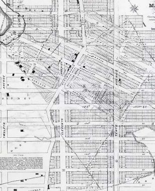
This map, drawn in 1878, shows Manhattanville’s street layout which ran askew of the Commissioners’ Plan grid pattern that was drawn up by surveyor John Randel Jr., instituting the island’s street grid system, approved in 1811. Since then the city had gradually spread uptown, laying out streets, leveling hills, filling in ponds. Some small towns, like Yorktown and Harsenville, left no discernible trace of their old layouts — the grid pattern absorbed them. Others, like Seneca Village, were swallowed by Central Park.
Manhattanville, though, was a bit different, and like Greenwich Village, it more or less defied the Commissioners Plan and in some cases, maintained its old street layout. Over the decades a good deal of it has been erased. But two of the main streets retain their old routes: check the map for Manhattan and Lawrence Streets. Both are still where they always were. The bend West 125th Street (Dr. Martin Luther King Blvd.) takes west of Morningside Avenue is the point where Manhattan Street began; likewise its partner to the north, Lawrence Street, now West 126th. Manhattan Street was renamed West 125th in 1920, and the old route of West 125th west of Morningside Avenue became LaSalle Street (for Jean Baptiste de la Salle, a founder of the Brothers of the Christian Schools, an order that founded Manhattan College which has since moved to Riverdale in the Bronx).
Map: Manhattanville, Old Heart of West Harlem, Eric K. Washington, Arcadia 2002


Meanwhile, way downtown, tiny Manhattan Street runs for one block, running north alongside PS 188 (The Island School) on East Houston Street and pieces of East 3rd and Lewis Streets that surround the school were also preserved and appear in signage on the exterior of the school, which as built decades before the surrounding Lillian Wald Houses. Its accompanying Wald Playground also breaks the houses’ dominance. This Manhattan Street has been demapped and doesn’t appear in directories, nor does the Department of Transportation vouchsafe a street sign. Google Maps calls it “Lillian Wald Drive.”
Check out the ForgottenBook, take a look at the gift shop. As always, “comment…as you see fit.” I earn a small payment when you click on any ad on the site.
7/28/25
6 comments
The #1 train station in your photo was originally called Manhattan Street but of course took the 125th Street name after the re-naming, unlike many Queens stations that have retained long-disappeared alpha names since replaced with numbered streets. The viaduct is noteworthy due to the steep slopes on either side of 125th St. To keep the tracks level, they rise to about 50 feet above street level, carried across 125th on an arch bridge. Quite a significant piece of engineering, and amazingly in daily heavy use 121 years later.
[…] Source: MANHATTAN’S LOST MANHATTAN STREETS […]
Oddly enough, there’s a Manhattan Street on Staten Island way south in Tottenville, about as far from Manhattan as you can get.
Surprisingly there is more of a Manhattan Avenue in Brooklyn than there is in Manhattan.
There is also a Manhattan Beach neighborhood in Brooklyn, to the east of Coney Island and Brighton Beach. Also a Manhattan Beach near Los Angeles as well.
There is also a neighborhood in Brooklyn known as Manhattan Terrace, though it’s probably more associated with Ditmas Park.