

WAY BACK in 1999. the dawn of the Forgotten NY era, I profiled Lake Place, an odd east-west alley in Gravesend running east from 86th Street at West 11th Street to Van Sicklen Street north of Avenue V. After 26 years, I’m thinking it’s time for an update. Forgotten NY was technically limited in its early days. I did not use a digital camera equipped with a chip enabling me to obtain hundreds of photos in one day: instead, I used rolls of film, 24 or 36 shots, which meant I had to be very judicious about where I aimed the camera. Even so, I was even more of a novice photographer than I am now and got several duds. (Unlike some of my “photoblog” compatriots, I am not about getting the perfect shot and am no photography professional. Nonetheless, one of my photos of Corona Yards was selected by Peter Dougherty to go on the back cover of his annual update of his excellent “Tracks of the NYC Subway.”) I still consider myself a rank photography amateur who gets very lucky sometimes.
In addition, though I owned a scanner in the early days, it was the era of the dial-up modem and I deliberately scanned photos small: no more than 5″, so they would quickly resolve when “saved for web” using Adobe Photoshop, which in 1999 cost less than $200 to purchase. In 2025, both Adobe and the Microsoft software suite (Word, Excel, etc) are so expensive they require a monthly subscription. Thus by today’s standard, my early pages feature postage stamp images. I would like to return to those early pages and redo them with larger images, but I’d need to revamp hundreds of pages. It’s a gradual process.


I can trace my awareness of Lake Place back to the mid to late 1960s. I developed an interest in NYC street maps, and later street maps from other communities, as well as the “Little Red Books” that listed streets in alphabetical order, giving their beginnings and ends, house numbers, intersecting streets, and bus and subway lines that would get you there, published by Geographia and other firms. I became so obsessed that I would sit at my desk with note paper and carefully copy down lists of streets, beginnings and ends, in numbered order. Eventually my handprinting became so precise that to this day I still admire my handprinting and want to digitize it as a font.
I obtained my first Hagstrom Brooklyn street map on a trip with my parents to Gertz Department Store in Jamaica, Queens. We lived in Bay Ridge. Why so far afield? My father desired a wood wall unit that would carry his tape recorders, turntable, and album collection. He found one which he kept all the way to his death in 2003. I would have liked to inherit it, but I had no room in my apartment for it, so it has vanished into the ether. I remember much from that day, including his sending a steak back twice because it was too rare; he did not even like one bit of pink in his steak. Strangely I do not remember details from our jaunt on the J train, which still ran past Gertz in 1968.
That year I took my first bicycle foray outside of the Shore Parkway bike path along the narrows. It was a brown Schwinn. I made it as far as Neptune Avenue and the elevated Culver Line at West 6th, where I spotted an an ancient castiron Corvington lamppost along a section of Triton Avenue that was then in the process of being eliminated. The curb cuts might still be there but Triton Avenue is long gone. It’s very possible that I spotted Lake Place on this ride since I was coming from Bay Ridge, to the northwest.
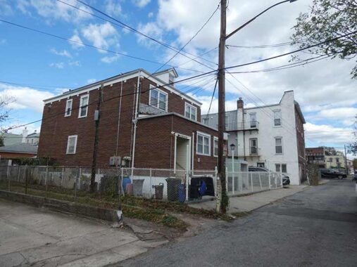
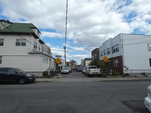
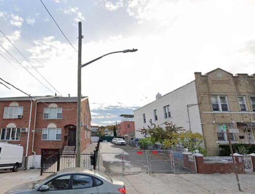
After a couple of squares at L&B Spumoni Gardens it was time to begin. Pictured above is the west end of Lake Place at West 11th, just west of 86th Street. One of the alley’s few fire hydrants can be seen, and the Department of Transportation is generous with street signs along the west end of the alley. It also maintains street lighting, though in a half hearted manner.
The DOT’s rules for what alleys get street signs and lighting are Byzantine. If the street is officially mapped, the street gets both. If not, sometimes there are signs, sometimes lights, sometimes neither. Near my place in Little Neck is a road that goes through Udall’s Cove Park to Douglaston. Houses on the eastern end have 39th Avenue addresses, while the lone house by the park’s Aurora Pond is on “Sandhill Road.” Neither has earned a DOT street sign. However, at what locals call the “back road”‘s western end ia sign for “Bayshore Boulevard,” which no one calls it. Me, I call it the Street With Three Names.
The west end of Lake Place, west of the Sea Beach BMT (N train) is open to traffic and is actually rather busy as many area residents use it as a shortcut. There are occasional sidewalks, and an occasional one or two family house. Houses are numbered going west to east as are the lettered avenues U, V, etc. that parallel it. This is the lowest house number on Lake Place, Number 15.
#48 Lake Place is seen on the right, just west of West 9th Street.

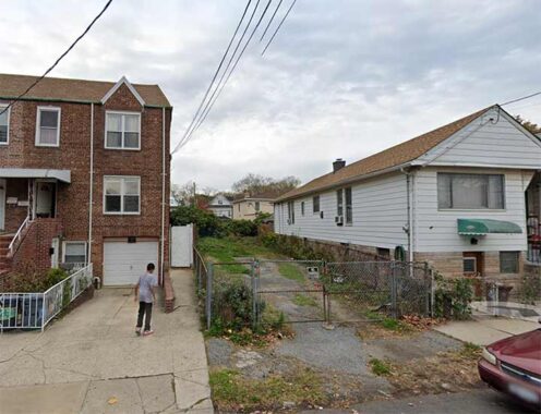
Lake Place, looking east from West 9th. The house on the corner looks much like it did in 1940. Note that because of the missing sidewalk, the phone pole carrying the streetlamp has to be placed at roadside.
The same can be said of the brick attached dwellings at Lake Place and West 9th, here looking west, but metal canopies have been added above the entrances.
More attached brick houses on Lake Place, from right to left, #60, #62, 64 and 68, 62 and 64 possibly built by the same developer as the corner building at West 9th.
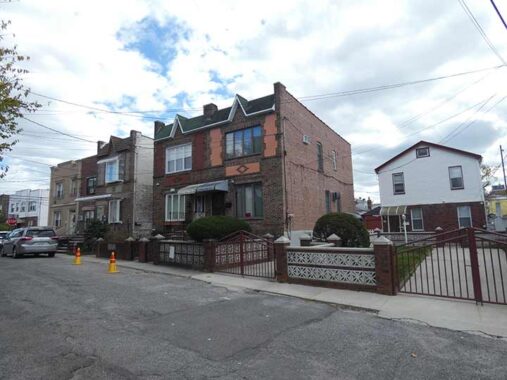
Ironically, the dead end section of Lake Place between West 8th and the subway cut features the greatest concentration of private dwellings, as six such houses face off across the lane.
On the north side of Lake Place there’s an unusual phenomenon I call retrograde house numbering, as the house numbers go from #73, on the corner of West 8th, then #69, then #67, according to Open Street Map. Google Maps disputes this, and says #67 is actually #79.
The two references also disagree with the house numbering of the small, modern building overlooking the subway cut, #81 vs. #95. In any case, the house numbering is in retrograde as #69 is east of #73. A few dwellings on nearby 86th Street also exhibit the phenomenon; I don’t know how it arises. Perhaps Gravesend historian Joe Ditta, who lives nearby, can clear up the correct house numbering.
On the south side of Lake Place, house numbering proceeds in cardinal order, #74 to #76 to #82 (though that raises another question about why so many numbers are skipped).
Lake Place was formerly continuous, across what I am guessing was a Sea Beach steam railroad grade crossing (unless the lane was interrupted by railroad tracks sans crossing) until 1914, when the tracks were placed in an open cut and became part of Brooklyn Rapid Transit, then Brooklyn-Manhattan Transit (BMT), then the Transportation Authority, then the Metropolitan Transit Authority. Trains running here were numbered at first from 1928-1964 as the #4, and from then till today as the N train. There was a brief express line running on the center rail in the 1960s, the NX.
Of the four subway routes that go to Coney Island, the D, F, N and Q, I find the N the least interesting (though it hangs onto its 1970s R-46 subway cars) because all you see between New Utrecht Avenue and 86th Street is the concrete walls of the open cut, though the arched elements and columns on the platforms promote some looks, and I have begun to pay attention to the 1910s-era station houses.
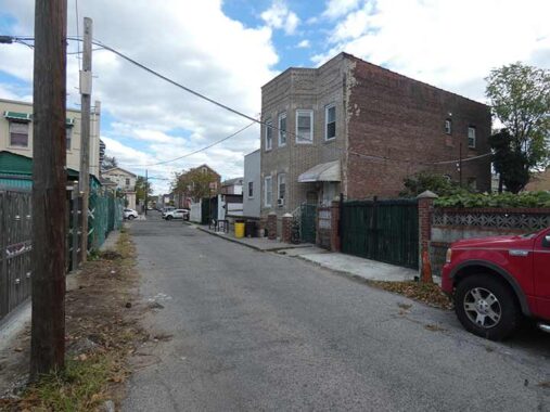
I used Google Street View for images of Lake Place east of the Sea Beach RR cut. Much of the lane east of the subway has been privatized and closed off, though the dead end west of West 7th and the section running east from West 7th east to West 6th, shown above, is still navigable by auto. The Department of Transportation chooses not to vouchsafe street lighting here and the pavement is rutted and pebbly.
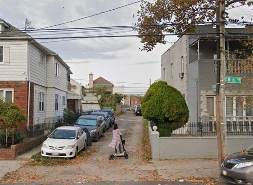
Lake Place, looking west from West 6th. In Gravesend, West 6th is a major secondary north-south route, with two lanes and two-way traffic. There are street signs here, but they’re 1980s vintage and are left over from the era when the lane was fully trafficked.
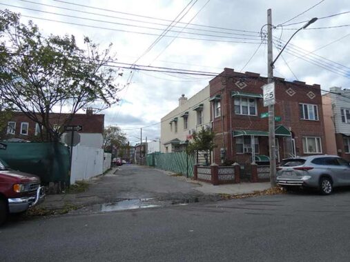
Lake Place looking east from East 6th. The lane is privatized and acts as a driveway to a single midblock house between West 6th and West 5th. Note the street lighting, again left over from its former career as a public thoroughfare. The change happened approximately two decades ago. My guess is that the residents of Lake Place between East 6th and Van Sicklen Street lobbied for the change. Lake Place is not a “through” street in its easternmost two blocks as its connections have been severed.

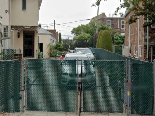
The Google Street View smudge machine was turned on at West 5th and Lake Place, as some area residents wish to keep images of their homes private. Here, Lake Place’s private nature is quite evident, as grass has grown on its unpaved surface. Again, the presence of a street lamp hints at former public use.
Lake Place at its east end, looking west from Van Sicklen Street. If you look carefully, there’s a midblock streetlamp that has even been updated with LED tech, even as it lights a privately owned driveway.
Lake Place History
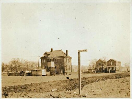
Gravesend historian Joe Ditta sent along this image by renowned NYC street photographer Eugene Armbruster (all NYC photographers should worship at his altar) of Lake Place at west 5th Street looking south to Avenue V. The two peak-roofed houses on Avenue V on the right are still there. The sign was probably added by an area resident as Brooklyn street signs in this era were black with white lettering, with metal “humpback” signs on more heavily trafficked streets.
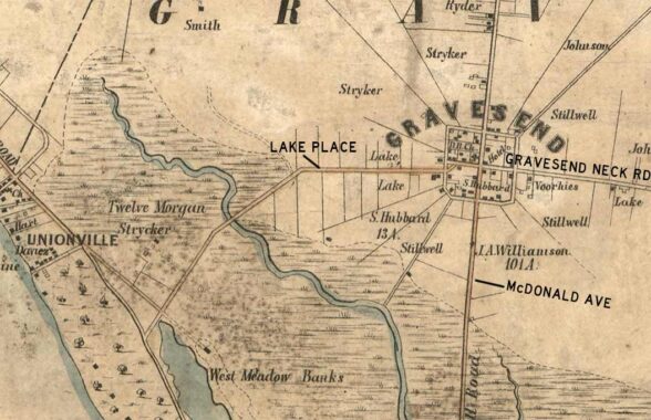
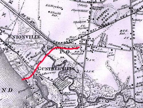
The earliest map showing Lake Place I have access to is a Dripps atlas section from the year 1852. Gravesend was settled in 1643 when Lady Deborah Moody, seeking relief from religious oppression, obtained a grant from the Dutch leader of New Netherland at the time, Willem Kieft. The square town plan of central Gravesend still exists today; Shell Road, now McDonald Avenue, runs south, Gravesend Neck Road east, and what we now call Lake Place west. The road formerly extended west and southwest, linking with another early thoroughfare, Mill Road, where Gravesend meets Bath Beach in what was called Unionville and then Guntherville after Charles Gunther built a surface railroad called the West End from Greenwood Cemetery to Brooklyn’s south shore. After numerous changes, it’s now the D train. These old roads were likely Native American trails originally, as were so many of the area roads such as the Boston Post Road.
There were numerous bodies of water in the area that have now disappeared in favor of landfill. The winding squiggle is Hubbard’s Creek, named for an early landholding family; we still have a Hubbard Street. Additionally, part of Unionville was on a peninsula, separated by Harway Basin, a dammed inlet of Coney Island Creek, itself still connected to Sheepshead Bay in what was an extremely marshy region.
Lake Place, and Lake Street, the southern stretch of Dahill Road, are not named for bodies of water. Since the 1800s Lake Place has carried the name of an early settler, W.B. Lake. One of the Lake family homes still stood on Avenue V near Van Sicklen Street until 2000 or so. According to historian Ditta, it has carried many names, including Gravesend Common Highway, Highway to West Meadows, Road Through Barrens to the Bay and Lake Lane.
Moving forward to 1873 and the detailed F. W. Beers map of Gravesend, we see Lake Place still running to Unionville, now with an extension to Gravesend Bay, along what are now 27th Avenue and Bay 41st Street. No trace remains of its older section (I have checked on aerial views). 86th Street is shown all the way to McDonald Avenue, but was likely still a developer’s dream. Names currently on street signs, such as Stryker, Emmons, Hubbard and Harway, can be seen on the map.
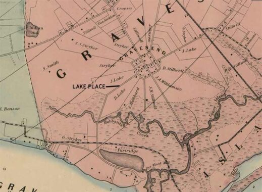
1900. On this map, note the unusually shaped farm plots radiating from the Gravesend town square plan. The West End RR appears as a dotted line, but the Sea Beach RR, which traveled to the sea Beach Palace in Coney Island and opened in 1877, is not shown. It’s likely that the map was produced by developers with an interest in the West End RR. The now-lost waterways Harway Basin, Hubbard’s Creek and Indian Pond, in the approximate location of Bensonhurst Park, were still present.
Lake Place ran straight through the Jacobus Lake farm property, likely leading to its Lake Land and Lake Place monikers.

By 1922, the area had been fully plotted with a street grid, though it was largely undeveloped; the West End and Sea Beach lines helped in that regard. Hagstrom clearly did not believe Lake Place would survive, and omitted it from its new map of the region. Nevertheless, it persisted, and made its way onto later editions.
Check out the ForgottenBook, take a look at the gift shop. As always, “comment…as you see fit.” I earn a small payment when you click on any ad on the site.
10/9/25
2 comments
Hey Kevin, isn’t the Indian Pond in the location of Seth Low Park? It mentions Bensonhurst Park above.
No lakes at Lake Place, but concerning Indian Pond, I’ve written about it.