

THURSDAY, November 23, 2017, Thanksgiving Day, dawned sunny and bright. I usually have been at one cousin or the other’s Thanksgiving extravaganza but that year, they were doing it on the weekend, thus I was at loose ends. Perfect photography conditions, though, if I didn’t mind the harsh shadows. So I hatched a plan. Why not link two neighborhoods that have nothing to do with one another with a walk? I arrived at Sunset Park to Maspeth, which would take me through Borough Park, Lefferts Gardens, Crown Heights, Bedford-Stuyvesant, Bushwick, Ridgewood and Maspeth. I walked from the light of day to the dark of night, nonstop (maybe a bathroom break, I forget). To my surprise it totaled only 12-13 miles; I know people who have walked triple that in one walk. It’s 8 years later, and at age 68, my back as well as other parts will no longer permit a nonstop walk like that. It’s not my longest: that was the full length of Metropolitan Avenue, Williamsburg to Jamaica, in May 2015.
I obtained over 300 photos; I won’t use them all but I’ll be splitting this walk into multiple pages to avoid the ever-present TLDR issue. And to make it easier on me.
GOOGLE MAP: SUNSET PARK TO MASPETH
^ Open the map in a separate browser window and follow along with me!
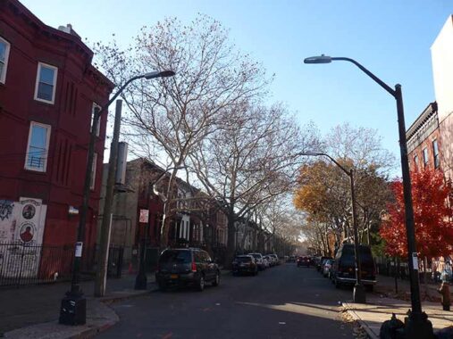
Parkside Avenue
I wound up walking the entire length of Parkside Avenue, which is aptly named because it skirts the southern edge of Prospect Park and the northern edge of the Parade Grounds, now used mostly for athletic field but was once a military training grounds and a site for formal military parades. Parkside Avenue extends east from Park Circle, the north end of Ocean Parkway and Coney Island Avenue, to New York Avenue at Kings County Hospital.
In 1859, a board of commissioners was selected to to investigate areas to build a public park in Brooklyn similar to the one then under construction in Manhattan. Seven proposals were offered, including Ridgewood and Bay Ridge, which were then not in the city of Brooklyn proper. Another was on a hill called Mount Prospect, on the road that would become Flatbush Avenue near the Brooklyn-Flatbush town border. This location was selected, and the commissioners selected Egbert Viele, who was chief engineer of Central Park, to begin work on the project.
Viele was stymied by the outbreak of the Civil War. At the conclusion of hostilities, the plan was placed in the more than capable hands of Frederick Olmsted and Calvert Vaux, who had landscaped Central Park before the war. Prospect Park was completed by 1870. On Parkside Avenue, I encountered several Prospect Park highlights that few talk about.
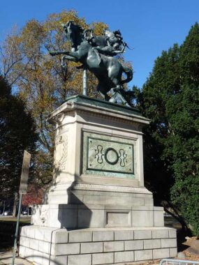
At Park Circle, the striking visual impact of the twin Horse Tamers sculptures by Frederick MacMonnies greets visitors on each side of the drive leading into the park from the Circle. The sculptures, dedicated in 1899, were originally called “The Triumph of Mind over Brute Force.” Some reviewers compare it to Guillaume Coustou’s Horses of Marly in the Place del la Concorde in Paris. Note that the tamer is using a curved dagger, known as a quint, to subdue the steeds.


Can you imagine such detail and care being included in the design of, say, a bus shelter today? Yet these twin structures flanking the Horse Tamers were built as horsecar shelters by Stanford White in 1896. They feature marble benches and intricate roof ironwork. Today they offer a cool respite from heat waves and shelter from showers.


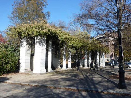
The Peristyle, also known as the Grecian Shelter, can be found on South Lake Drive, seen up a hill from Parkside Avenue. Though it looks, with its numerous Corinthian columns, as if it could have fit in in Greece in the classic era, it is actually a Renaissance-style limestone structure built by famed architects McKim, Mead and White (who went on to design the old Penn Station) in 1903. Corinthian columns are noted for their design flexibility. Note that these feature mushrooms.


A last gasp of fall color, along East Drive in southern Prospect Park.
A pair of Ionic columned granite colonnades adorned with wisteria adorns the Park’s southeast entrance at Parkside and Ocean Avenues. It was completed in 1904 by famed architects McKim, Mead and White.


The Parkside Avenue station on the Brighton Line serving the Q local train is another of Squire Vickers’ BMT stationhouses built in the 1910s, which can be found on the Sea Beach (N) and a couple of West End (D) stations as well. This seems to be the only one, or one of the few, stations that preserves its original lamp sconces, which now carry LED bulbs where they once had incandescents. These stations are conservatively, but attractively, designed with beige tilework and customary colored diamond terra cotta.


Parkside Court is a dead end on Parkside Avenue between Ocean and Flatbush Avenues, a semi-private enclave built by developer Thomas Sinnott from 1906-1907. It was mentioned by the Historic Districts Council in its Six to Celebrate series:
“[Sinnott’s] idea in erecting these has been to provide a structure in which a man with a family can have ample room and live as much by himself as in a single family house and yet have a full suite to rent for enough to pay all the carrying charges on his investment.” Sinnott also touted the “unique” rear piazzas, claiming the houses on the west side of the street overlooked Prospect Park. The stone rubble wall at the end of the court is an original feature, supposedly “adorned with plants and vines.”
Famed horror fiction writer Howard Phillips Lovecraft, usually associated with Providence, Rhode Island, lived in two residences in Brooklyn from 1924-1926. His first was in an apartment with his wife, Sonia Greene, at 259 Parkside Avenue, shown here on the right, just east of Flatbush Avenue. In that era, it was a more upscale neighborhood than now. Lovecraft was unable to amass much income other than what he sold to the pulps and from ghost writing, and Sonia, a milliner (she sold women’s hats) left to build a business in the Midwest.
Lovecraft moved to 169 Clinton Street in Brooklyn Heights, now upscale but then a slum. Depressed by life in New York, he moved back to Providence in 1926, and initiated (amicable) divorce proceedings with Sonia, who later learned to her dismay after she remarried that the divorce had never been finalized before HP’s death in 1937.
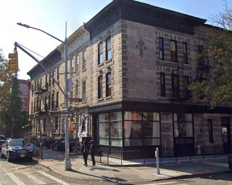
Now entering Prospect-Lefferts Gardens, named for a Dutch colonial family whose farmhouse stands nearby in Prospect Park. This grouping of attached houses on Parkside just west of Bedford Avenue, designed by prolific Brooklyn architects Benjamin Driesler and Axel S. Hedman for developers William A. A. Brown and Eli H. Bishop & Son and built from 1909-1914, was granted its own Landmarks Preservation Commission historic district in 2022.


The mural featuring African American notables on a day care center and former garage on the NW corner Parkside and Bedford Avenues, completed in the summer of 1991, was sponsored by Mayor David Dinkins’ Safe Streets Safe City initiative. The program earmarked new taxes to fund the hiring of thousands of new police officers and criminal justice workers. The increase in the Police Department permitted Dinkins’ successor, Rudy Giuliani, to implement zero-tolerance policy on quality of life issues; this “broken-windows” approach led to the capture of criminals that otherwise would have been free to commit more serious crimes. Overall, crime dropped dramatically in NYC during the 1990s, with annual murders dropping from over 2200 to under 600, and have continued to mostly drop since.
Despite Dinkins’ Safe Streets Safe City initative he lost narrowly to Giuliani in 1993 due in large part to his perceived powerlessness to prevent the Crown Heights Riots in August 1991 and perceived inability to do anything about them once they started.
From its website: The Crown Heights Youth Collective is a multidimensional, self development program located in Central Brooklyn. Since its inception in 1978, over 100,000 residents have benefitted from its educational, cultural, social programs and the Rights of Passage project. We established many Peace Zones throughout the borough, the community beautification gardens, development of agricultural gardens, feeding of the community and beautification through murals instead of graffiti. The agency’s co-founders Dr. Robert H. Johnson, Dr. Myrah E. Brown Green and Mr. Richard E. Green perceived the need for advocacy and service oriented organization to stem the tide of urban decay. Its trust was toward a renewed excellence and the establishment of community progress. The founders realized that a basic catalyst for change lies in the upliftment and reaffirmation of the aspirations of youth.
Bedford Avenue, which runs from Greenpoint south to Sheepshead Bay, is the longest street in Brooklyn not part of an expressway, edging out Flatbush Avenue by less than a mile. The name of Bedford Avenue is in some dispute — the avenue originally ran through the neighborhood of Bedford (now the western section of Bedford-Stuyvesant) which was either named for England’s Bedfordshire or the Dutch Bestevaar, “meeting place of old men.” Bedford Avenue was assembled piecemeal from the original road through Bedford, the annexation of a northern section in the City of Williamsburg(h) formerly called 4th Street, and the southern section was gradually extended south during he late 1800s and early 1900s.
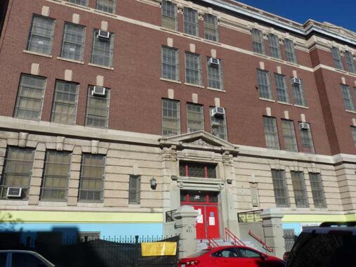
PS 92, #601 Parkside Avenue between Bedford and Rogers Avenues, is also the Adrian Hegeman School:
Adrian Hegeman (1625-1672) helped settle Flatbush (Midwest) Kings County, Long Island, New York. During his lifetime, he acquired more than 350 acres of land and became one of the largest property owners in the Village of Flatbush. His original deed from April 12, 1661 is signed by Peter Stuyvesant, the Director General of the Colony of New Netherland. It is perfectly preserved and is held at the newly-formed Center for Brooklyn History. It is a collaboration between the Brooklyn Historical Society and the Brooklyn Public Library.
|
Adrian was instrumental in the establishment of the Old Flatbush Dutch Reformed Church and School. He served as the first “shout” or mayor of the five villages which would eventually become Brooklyn. He was the first teacher at the Flatbush School in 1658. A bronze plaque honoring him as a teacher is attached to Erasmus Hall High School in the general area of where the old school once stood. Erasmus Hall High School is located across the street from the church and cemetery on Flatbush Ave. Erasmus Hall Academy, built in 1786, is located behind Erasmus Hall High School. Adrian Hegeman Public School number 92, Hegeman Avenue, and an affordable housing high rise, The Hegeman, in Flatbush, are all named in his honor. [Find A Grave]
Hey, East New Yorkers: Is it pronounced HEGGA-min, HEEJ-min, or something else?


Outside the Social Security office at Parkside and Nostrand, I bumped into Mark Levy of Levy’s Unique New York Tours (now known as Spread Love NYC Tours), Forgotten NY supporters from the start. Mark was helping out with a food giveaway.


More painted images, this time of Barack Obama, Malcolm X, Nelson Mandala, Martin Luther King, this time in the private lay area of the Parkside Academy at Parkside and Nostrand.

Kings County Hospital is the oldest place of medical treatment in Kings County and possibly all of New York City. It was founded as Brooklyn County Almshouse, a place for the destitute, in 1830, with its first new building constructed in 1837, when most of the sirrounding area was countryside and farms, with the town center of Flatbush some distance to the west. The grounds mainly served as a “lunatic asylum” for some decades until its hospital took over as the main service. It can count several firsts: the first open-heart surgery performed in New York State; Kings County Hospital is the oldest place of medical treatment in Kings County and possibly all of New York City. It was founded as Brooklyn County Almshouse, a place for the destitute, in 1830, with its first new building constructed in 1837, when most of the sirrounding area was countryside and farms, with the town center of Flatbush some distance to the west. The grounds mainly served as a “lunatic asylum” for some decades until its hospital took over as the main service. It can count several firsts: the first open-heart surgery performed in New York State; the world’s first hemodialysis machine; first studies of HIV infection in women; and first human images made by magnetic resonance imaging (MRI).
Today Kings County Hospital grounds are defined by New York, Albany and Clarkson Avenues and Winthrop Street.
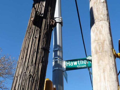
Why get a photo of a telephone pole at New York Avenue and Hawthorne Street? If you look carefully you can see a pair of very rusty brackets that used to hold street signs, likely of the “humpbacked” variety that also showed the cross street.
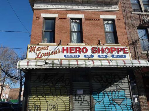
A vintage plastic letter sign for Mama Louisa’s Hero Shoppe, closed of course on Thanksgiving, at Rutland Road and New York Avenue. Reviewers note the artichoke parm is the sandwich to order.


Heading east on Midwood Street I encountered a trio of private walkways with attractive center malls and attached houses. This is in a neighborhood colloquially called “Dodgertown” and many Brooklyn Dodgers made their homes in the area during the 1950s, a short distance from Ebbets Field. This is the former Coral Gardens complex, constructed in 1925 between New York and Brooklyn Avenues and Maple and Midwood Streets. This development consists of three landscaped pedestrian courts, all Florida-themed: Tampa, Palm and Miami Courts. Vehicular access is provided by three rear alleys; homes on the east side of Tampa Court have their rear access on Brooklyn Avenue. I discuss the area on this FNY page.


When possible I rarely miss the chance to explore short, one block “Places” or “Courts.” Lamont and Balfour Courts, between Lefferts Avenue and Empire Boulevard east of Brooklyn Avenue, feature attached Tudor-ish dwellings, likely built by the same developer. Like many streets in this realm, they were given British sounding names for an aura of sophistication.


Heading north now on Kingston Avenue, the main shopping drag of Crown Height’s Hasidic and Orthodox community. In Bedford-Stuyvesant, Crown Heights, Flatbush and East Flatbush, you will find a succession of avenues that run north to south that are named for major cities in New York State. Graciously, city planners acceded to put New York Avenue first, as you travel from west to east. It’s followed by Brooklyn, Kingston, Albany, Troy, Schenectady, Utica, Rochester, and Buffalo. They seem to be in the order you would encounter them if you drove the New York State Thruway all the way to Buffalo. Since these avenues were laid out in the 1800s, Brooklyn’s planners likely had the route of the Erie Canal in mind, since the Hudson and Mohawk Rivers also follow this route. Left out, among larger NYS cities in this sequence, are Syracuse and Rome. Since Syracuse had been settled by Native Americans and later, British colonists and has had its present name since 1819, I can’t account for the omission.
Once the “City Avenues” get as far south as Flatbush, they stand in the place of the East numbered sequence: New York Avenue is in place of East 33rd, Brooklyn, East 36th, Albany, East 41st, and so forth. Kingston Avenue, though, doesn’t get further south than Winthrop Street at King County Hospital, because of a lack of enough north-south numbered streets between Brooklyn and Albany Avenues to accommodate it.
Kingston is the smallest town on the list, with a population of almost 24,000 as of the 2000 Census. It was briefly the capital of New York State in 1777, and was burned by the British the same year. Because of plentiful quarries in the vicinity, Kingston has supplied NYC with much of the materials used to build NYC’s bluestone sidewalks and later, concrete. It is about 6/10 of the way from NYC to Albany on the west shore of the Hudson.
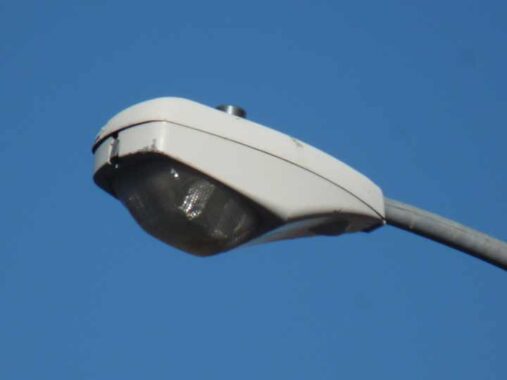
I found this Cooper OVX streetlamp fixture at Kingston Avenue and Montgomery Street, an uncommon make for NYC street lighting. It was soon after replaced, in 2017, for an LED lamp. LED lamp franchsies seem to have been distributed by borough, and Brooklyn most often employs the Cooper Verdeon series.


This colorful mural at Kingston Avenue and Crown Street was created by 250 7th graders in area schools and honors Rebbetzin Chaya Mushka Schneerson (1901-1988), wife of Rabbi Menachem Schneerson, last leader of the Chabad-Lubavitch branch of Hasidic Judaism.


Old school plastic-lettered sidewalk signs abound on this stretch of Kingston Avenue. They get the job done, why change? The SL in the phone number at Raskin’s stood for SLocum, which ages this sign considerably.
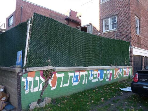
Unlike other NYC neighborhoods, Lefferts Gardens and Crown Heights abound with midblock service alleys, much like the numbered “public alleys” in Boston. I need a translation for this painted sign alongside one such, south of President Street at Kingston Avenue.
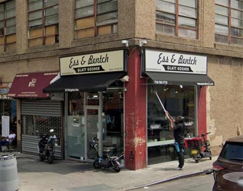
Kingston Avenue at Union Street. In Jewish neighborhoods, you often see the words “Glatt Kosher” on signs. Glatt is Yiddish for “smooth” referring to the strict kosher standard involving the smoothness of the lungs of the slaughtered animal. We are what we eat, and so the animal’s organs must be clean, according to regulations.


Though the sign points to the Brooklyn Children’s Museum a few blocks away, at Kingston Avenue and #792 Eastern Parkway we find the Jewish Children’s Museum (open to all children and adults, of course) which opened in 2004. The museum was proposed and built in the aftermath of the devastating Crown Heights riots in 1991 as a way of bringing together the disparate populations of Crown Heights and promote understanding between cultures. Kenny Bania from “Seinfeld” will be glad to know there’s a Mendy’s Kosher restaurant within.


This elaborate painted mural once graced the sidewall at Calabria Kosher Pizza at Kingston and Lincoln Place. Calabria moved out a few years ago, but had whitewashed the mural anyway. It wasn’t easy to paint all those words in ecclesiastical blackletter.
If you look at Crown Heights on a map, it appears that with the exception of Eastern Parkway, the east-west streets are the same width. Not the case. Some streets are 60 feet wide, some 70 feet wide. But Lincoln Place is especially narrow at 50 feet, too narrow for parking on both sides, while St. John’s Place, a block north, is 100 feet wide. My thinking is that since Lincoln Place is between two wide streets, it was laid out at this narrowness to allow for more buildings on the north-south streets.
[See Comments for a further explanation]


A flaw of urban planning in Brooklyn is the beauty of Prospect Park as the borough’s signature greenspace, and seemingly endless blocks of housing with few parks to serve the residents. Seeking to correct the absence of public space in neighborhoods distant from Prospect Park, in the 1890s, Brooklyn’s leaders designated a set of park blocks such as Saratoga Park in Bed-Stuy, McGolrick Park in Greenpoint, and Bedford Park in Crown Heights, among others. The Brooklyn Parks commissioner at that time was George V. Brower, whose name was later bestowed on Bedford Park. It is a welcome space of nature amidst the brownstones and apartment buildings. What makes Brower Park unusual is that it does not occupy its full superblock, with portions of the space given to the Brooklyn Children’s Museum and P.S. 289. The park has active and passive recreational features, but the unique elements are its art and architecture. The northwest corner of Brower Park contains the Brooklyn Children’s Museum, which stands out with its yellow facade designed by Rafael Viñoly in a 2007 expansion. It gives the museum a new look when it is actually the oldest children’s museum in the country.


Also at Brower Park, Kingston Avenue and Park Place, you find tributes to US Representative Shirley Chisholm, the first Black woman elected to Congress, representing Brooklyn’s 12th District from 1969-1983. In the spring of 1972 she ran for President thus becoming the first major party African-American Presidential candidate, and first female Democratic candidate. Chisholm is also honored by the Shirley Chisholm Building, #55 Hanson Place downtown, and by the new Shirley Chisholm State Park way, way out at the Belt Parkway and Erskine Street facing Jamaica Bay.
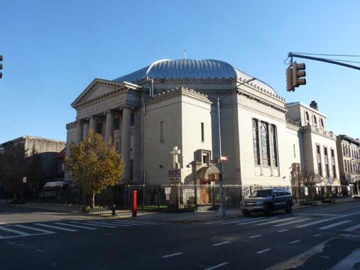
Across from the southeast corner of Brower Park is the former Shaari Zedek (Gates of Righteousness) synagogue, completed in 1925 on the site of Brower’s mansion. Designed for a wealthy community, this classical revival structure included classrooms, a gymnasium, bowling alley, auditorium, and a pipe organ. At its dedication, its lights were turned on remotely by President Calvin Coolidge from Washington. With white flight in the 1960s and an uptick in crime, the congregation declined. In 1969 it was sold to an African-American congregation, the First Church of God in Christ of Brooklyn. Whatever happens in demographics, the building and its surrounding blocks are landmarked, securing its future on the streetscape.


A sampler of buildings on Park, Hampton and Virginia Places. This is amid Crown Heights North III Historic District, one of a number of landmarked districts in the area that mostly ensure that the local architecture remains little changed. The Landmarks Preservation Commission has also published a walking tour of Crown Heights North, but west of Kingston Avenue.
Prospect Place and St. Mark’s Avenue in Crown Heights have a uniform design, with narrowed streets by curb cuts, and a center mall on St. Mar’s, as well as nonstandard streetlighting. These changes were initiated by the Bedford-Stuyvesant Restoration Corporation, the country’s first Community Development Corporation which sought to reverse the decline of the neighborhood with new parks and housing development.


Revere Place, between Bergen and Dean Streets east of Kingston Avenue, is located within the Crown Heights north historical district, so all the buildings on it are safe from demolition. At 11 Revere Place, Richard Wright wrote the novella The Man Who Lived Underground, and the book 12 Million Black Voices.
For many years the remnants of the black and red glass exterior of renowned jazz club the Kingston Lounge was visible, for over 15 years until 2020, at the SW corner of Kingston Avenue and Bergen Street. The whole story is on this FNY page.
Check out the ForgottenBook, take a look at the gift shop. As always, “comment…as you see fit.” I earn a small payment when you click on any ad on the site.
11/30/25
3 comments
Kingston Ave is replaced by E 39 St south of Kongs County Hospital
The painted sign south of President Street alongside Kingston Avenue – The Hebrew translation is: Micha 4:4 “they will sit, each many under his vine and under his fig tree”
It’s talking about the end of days.
Kingston Avenue was originally called Hudson Avenue, for the City of Hudson, Columbia County. Hudson, NY is several miles upstream from Kingston and the renaming did not affect the city order of the avenues. Renamed after the City of Kingston (to eliminate duplication with Hudson Avenue in Vinegar Hill) by the Brooklyn City Council on November 29, 1869, effective December 13, 1869. (Brooklyn Daily Eagle; Tuesday, November 30, 1869; page 2)
The reason for the varying widths of Lincoln and St. Johns Places is directly related to Olmstead’s design of Eastern Parkway. When the street grid was first laid out in the 1830s through what became Crown Heights the cross streets were all 60′ wide. There was no Eastern Parkway, just Sackett Street. When Eastern Parkway was planned out circa 1868 adjustments had to be made to the configuration of adjacent blocks so as not to have small, shallow lots facing Eastern Parkway. This was accomplished by the narrowing of Union and DeGraw (Lincoln Place) Streets and the widening of Douglass (St. Johns Place) and President Streets. This created a certain uniformity to the blocks so that they would be developed in a desirable manner.