

HOPING I’ll be able to return to lengthy walks sometime soon but fortunately, I do have a backlog of photos such as the 133 I got during a June 2024 walk from Brooklyn Heights to Prospect Park, primarily using Hicks, Columbia, Union, Sackett Streets and Berkeley Place. As with the previous post from Sunset Park to Maspeth, I’ll need to divide things among multiple posts. As with all my forays, I seek out bits of infrastructure and architecture I find interesting, as I hope that’s what you’re seeking as well.
GOOGLE MAP: BROOKLYN HEIGHTS TO PROSPECT PARK


To get to my designated finish at Prospect Park I decided to use Sackett Street and Berkeley Place (all of which used to be called Sackett, but I’ll get to that in Part 3), with a detour on Union Street to cross the Gowanus Canal. There were two prominent people named Sackett in early 19th Century Brooklyn: Samuel Sackett (1744-1822), who built hospitals and libraries in Brooklyn Village, and his son, Clarence Sackett, a lawyer, state assemblyman and village trustee who helped Brooklyn acquire its charter and served as alderman. Sackett Street is likely named for the latter. I chose Sackett as many changes have been made on the dead-end section near the Gowanus Canal. Shown above is its dead end stub between an Brunt Street and Buttermilk Channel. The stub once connected with Hamilton Avenue in a section named Ferry Place. Streets west of Van Brunt have been replaced by Red Hook Terminal.
The brick building on the left was once a coffee and tea importing warehouse owned by W.S. Quinby, author of “How to Make Perfect Coffee.”
Info: Brooklyn By Name, Leonard Benardo, Jennifer Weiss, 2006 NY University Press
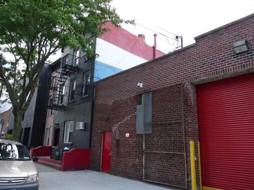
#96 Sackett, between Van Brunt and Columbia, has an exposed north wall painted in the colors of the French flag in bars of red, white and blue: however, on the flag the bars are vertical, not horizontal. I wonder what the story is. in the colors of Netherland’s flag. I wonder what the story is. (Luxembourg’s is a similar flag, but with light blue. This could be a flag of either.
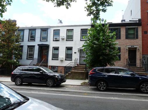
I photographed #102 and 100 Sackett next to #98 to illustrate the jarring nonuniformity of residential buildings in nonlandmarked areas. #100-102 were built in 2017. I don’t mind the large, square window treatment, actually. Sackett between Columbia and Van Brunt is a mix of residential, auto repair and live poultry markets; many of the chickens killed here wind up on tables of nearby restaurants in prosperous Carroll Gardens and Cobble Hill.


The Human Compass Garden, SE corner of Columbia and Sackett, is named for a famed drawing by Renaissance artist and architect Leonardo da Vinci that shows two superimposed views of a man, each enclosed in a circle and a square respectively. It’s kept at the Galleria dell’ Accademia museum in Venice but due to its age and fragility is rarely exhibited. da Vinci was inspired by descrtiptions of the human proportion in architecural terms by the Roman architect and engineer Vitruvius.
A group of area artists cleaned up what had been an empty lot beginning in 1992. Over the years, the garden has hosted numerous off the cuff art exhibits, funded beginning in 1996 by the “Art in the Garden” program, with the help of grants from the Trust for Public Land and the Brooklyn Arts Council (BACA). It has been cared for by NYC Parks since 1998.


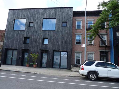
#213 Columbia Street, adjacent to the garden, is a new (2013) residential building designed by architect Orlando Garcia and built according to so-called “Passiv House” principles:
…a voluntary building standard focused on extreme energy efficiency, comfort, and low carbon footprint, achieved through super-insulation, airtight construction, high-performance windows, and continuous filtered ventilation with heat recovery, drastically cutting heating/cooling needs, saving energy, improving air quality, and ensuring consistent indoor temperatures year-round. These principles create ultra-low energy buildings, often requiring little to no conventional heating, and can be applied to homes, schools, offices, and other structures. —wikipedia AI robot
Sackett Street was vouchsafed a crossing over the BQE by Robert Moses in the 1950s. It hadles westbound traffic, while a block south, Union Street is eastbound; Union is two-way between 3rd Avenue and Grand Army Plaza.

#206 Sackett, near Henry Street, offers an American eagle, a pair of pilasters (half-columns) and what I presume is the date of construction above the pediment on the entrance.
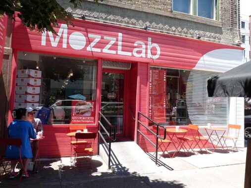
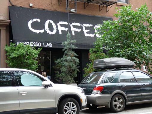
I find it odd to call a sandwich shop a “lab” but here we are at Sackett and Henry. Many of the sandwiches are made with mozzarella cheese, which in Brooklyn is pronounced approximately MOHT-za-rell. I was attracted by its unique red and white sidewalk sign and Helvetica typefont. I may stop in next time I am around. Mozzarella is sold in spheres, reflected by the “o” on the sign.
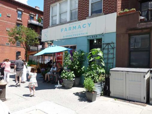
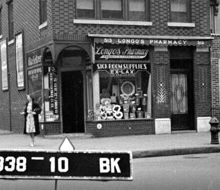
In Forgotten New York I have investigated the past practice of locating soda fountains in drugstores. Basically, long-ago fountain drinks contained stimulants or painkillers such as caffeine (in many modern sodas) or cocaine, as in original formula Coca Cola. In 2010 the owners of Brooklyn Farmacy, SE corner Henry and Sackett, went a step further and converted the old Longo’s Drugs into a premier ice cream, dessert and soda venue, a la the old Jahn’s and the present Eddie’s in Forest Hills, keeping some of the old pharmacy elements and bringing in new ones. Area dentists are very glad for the business. You can osmose the ice cream in safety for your blood sugar in these Yelp photos.
The exterior sign is also in an old fashioned type front, Copperplate.
|
|
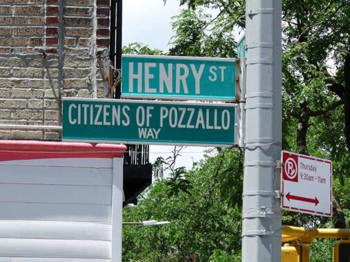
[In 2009 Henry between Sackett and Union was] officially been co-named “Citizens Of Pozzallo Way” in honor of the Society of the Citizens of Pozzallo. The Society was started in 1919 by immigrants from the Sicilian town of Pozzallo, Italy who formed an organization, to “promote fellowship and friendship amongst its members and to educate them to the American ideals in order to transition them to the American way of life and American citizenship.” Ninety years later, “La Societa Di Pozzallo” is still going strong and its members were visibly moved by the ceremony and by the speeches of local dignitaries. [Katia Kelly, Pardon Me for Asking, 2009]


A look at a set of wood garage doors on Sackett just east of Clinton and they way they looked in 1940. The older photo is a great shot, you can see clothes hanging on the line. Until 1947, Sackett Street hosted the #2 trolley line, which went all the way to East New York and Cypress Hills via Bergen Street and Liberty Avenue.
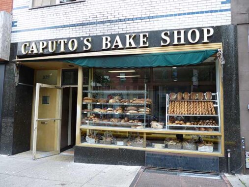
I enjoy getting photos of bakeries, especially in Italian neighborhoods. To use that word again, you can osmose the different types of bread and sometimes, even smell what’s being made within. Caputo’s is at #329 Court, one door from Sackett. According to The Infatuation, it has been in business since 1904 and is cash-only.
A new trend in signage is painting lettering directly onto the brickface as here. (Actually this was done from the late 1800s-on, as witness the fading ads around town that are gradually disappearing.) Did you know there’s an actual red hook in Red Hook? It’s on Commerce Street: see it here.
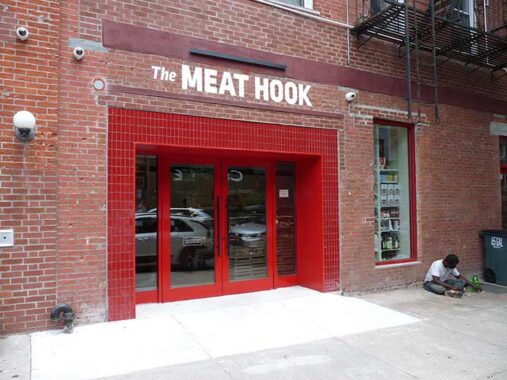
Naturally The Meat Hook, #301 Sackett, is a butcher located in two Brooklyn locations. Close enough for Red Hook I suppose. The chain was opened by Brent Young in 2009.
Calling eateries and coffee shops “labs” may be a thing, like “6-7” (oops, I hear that’s passe since the kool kidz have noted that the mainstream has noticed it). Obscured by the foliage is the cafe’s real name, Nerd be Cool, #314 Sackett. That seems to be an oxymoron, since nerds go around in 30-year old jackets purchased from Robbins Men’s and Boys taking photos of signs and lampposts.
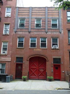
I was seeing red on this walk. #324 Sackett (I cannot find any details on it except for real estate listings) appeared to be a firehouse because of the red doors, but I can’t find proof. The wide entrance may indicate a former stables.
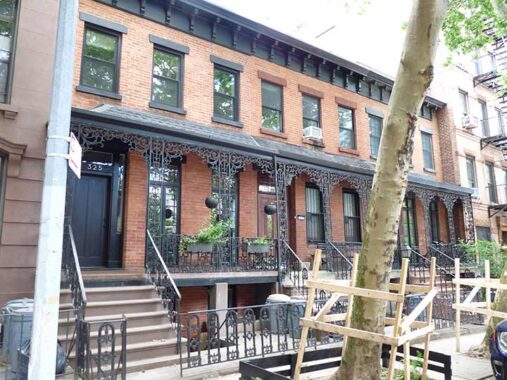
Across the street, #325-329 Sackett reminded me of photos of the old Rhinelander Gardens at 6th Avenue and West 11th in Greenwich Village, especially the metalwork on the porches.
#336-334 Sackett, across the street, appear to be wood frame houses that were given aluminum siding. #332, on the right, acquired its brickface exterior around 2022.


St. Agnes Roman Catholic Church is one of the largest and tallest structures in what used to be called South Brooklyn. The original church (Patrick Keely, arch.] was dedicated in 1888 on Hoyt Street between Sackett and DeGraw Streets by Brooklyn’s Bishop John Laughlin; after a fire claimed it in 1901, this much more massive edifice was designed by Thomas Houghton and dedicated in 1905 on Hoyt Street between Degraw and Sackett Streets. Its medieval Gothic Newark stone gargoyled tower is 130 feet tall and the nave, or central aisle, is 174 feet in length. 20 stained glass windows, imported from Munich, Germany, depict the life of St. Agnes of Rome. Two parishes, St. Paul’s on Court Street and St. Agnes, were combined in 2011 and the parish is now St. Paul and St. Agnes. The parish center, in an equally aged building, can be found at #433 Sackett.


Brickfaced dwellings on Sackett between Hoyt and Bond Streets. I call these “the bread and butter of Brooklyn residential architecture”; you can find whole blocks full of them. Homeowners treat them lovingly, witness the yellow and red doors on otherwise dark blue exteriors. But we are now encroaching on the new Gowanus development district.


2024


2015
You can see what ten years have done to the stub of Sackett in just a decade, and it took a lot less than ten years to change from a Belgian blocked dead end lined with parking lots, warehouses and garages and lit by a single curved-mastarm streetlamp to the high-rise haven it is becoming. In 2024 a bit of its old Belgian blocks had been preserved at Bond, but it’s likely paved over by now. Street View shows it further.
FNY chronicled this transition from old to new on Nevins on Sunday in March 2024.


The New Gowanus’ relentless push for new housing has claimed some aged and iconic buildings in this area, unprotected by the Landmarks Preservation Commission. At Bond Street and Union Street was a lengthy, two story slope-roofed building painted green, and the small sign on the door simply called it “The Green Building.” it was built in 1889 (though accounts vary: some say as late as the 1930s! That’s quite a swing) and was a brass foundry until 1987. Its occupant was an event space for commercial shoots, films, dance and theater performances, and corporate events. The interior featured original brick walls, soaring exposed beam ceilings. But that’s all gone now, as new urban planners consider one-story buildings to be wasted space. The cry used to be for livable, breathable green cities; now the push is for high rises everywhere, the better to cram more people in.
A reminder of the old Gowanus at Sackett and Bond. Undoubtedly this will be gone soon and admittedly, it’s ugly: but bland and blander will replace it.
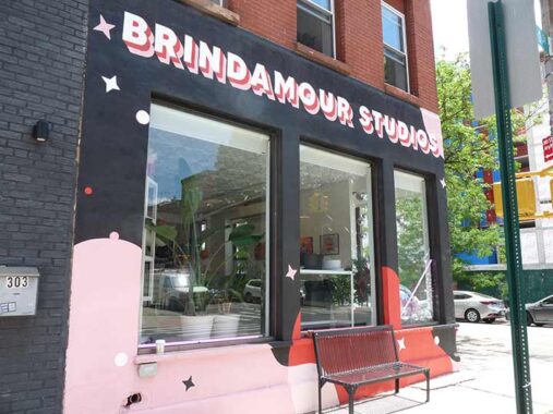
Handmade painted signs and art at Brindamour Studios, Bond and Union, “a full-service creative studio offering photography, videography, photobooths, and a micro events space in Gowanus, Brooklyn.” The drop shadow technique is often used by Noble Signs, a premier hand-painting signmaker located in East New York home to the NY Sign Museum. I’d bet they made this.
Crossing the Union Street Bridge I noticed a pair og retro-Triboro lampposts on the opposite side. There were the vanguard of Gowanus Waterfront Park, under construction in 2024 and opened the next year. I have it on this FNY page from 2025.


The Gowanus Canal was originally a creek running through empty marshes and fields. According to gowanus.org, the canal is quite old: it was begun in 1849, other accounts say 1855 (finished in the 1860s) by narrowing its predecessor, the Gowanus Creek, into a one and a half mile long commercial waterway to provide commercial access to Gowanus Bay. Developer Edwin Litchfield formed the Brooklyn Improvement Company for the express purpose of dredging the Gowanus Creek, then a fresh stream, and making it navigable. With the creation of the new waterway, barges brought in sandstone from New Jersey that was used to build the beautiful brownstones that today still line the streets of surrounding Boerum Hill and Park Slope. Unfortunately the buildup of the area contributed to the pollution of the canal, which would go on for over a century: the surrounding area’s raw sewage would be pumped directly into the canal, and the new gasworks, coal yards and soap factories along the canal’s length also dropped tons of pollutants directly into it as the years went by. As early as the 1880s the canal was foul and miasmic and its color had changed to a dark Pepto-Bismol shade, prompting locals to call it “Lavender Lake.”
I’m intrigued by what species of fish would thrive in this waterway. Large numbers of them were swarming under the bridge the day I walked across.
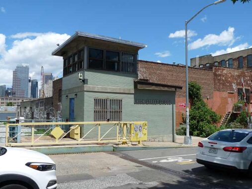
The Union Street Drawbridge, the northernmost of the five vehicular bridges that cross Gowanus Canal, is classified by the Department of Transportation as a double leaf Scherzer rolling leaf bascule bridge. It is 109 feet long, 56 feet wide and first opened March 4, 1905. The bridge seems rickety and fragile. Its twin bridge, the 3rd Street over the Gowanus, opened a few weeks later in 1905. This bridge seems to lose out a little in Brooklyn lore to the Carroll Street Bridge, a rare retractile bridge that dates to 1889, but has been closed for repairs for some years.
Beginning to flag so I think I’ll wrap this up with a short page sometime during the week.
Next: Gowanus Into Park Slope
Check out the ForgottenBook, take a look at the gift shop. As always, “comment…as you see fit.” I earn a small payment when you click on any ad on the site.
1/4/26
7 comments
I love your posts!
Have you considered making guide books with maps for those of us who would like to literally walk in your footsteps?
Forgotten New York the Book, with maps, is available on amazon
Ahh,the life of a bridge tender.Peruse the paper for a couple of hours
every morning while sipping your coffee in your little office high above
the fray…
I would love that job
Red, White and Blue in horizontal bars is the Dutch (Netherlands) flag.
When I was growing up in Connecticut some of the really old timers would call mozzarella something like sca-motz.
Not the flag of France, but that of Luxembourg.