

AMONG Forgotten New York’s many influences are the photographs produced by early 20th Century street photographers/archivists/authors Percy Loomis Spehr, Eugene Armbruster and E.E. Rutter, whose work chronicling the rapidly changing NYC can be found online in one archive or another. I can only hope that my work since 1998 will be thought of alongside those eminent photographers: but in the digital age, there are now thousands of street photographers who do similar work.
There is another person who inspired Forgotten NY’s work: Berenice Abbott (1898-1991), perhaps the best remembered and honored street photographer of the period, because of her artistic pedigree. She studied under Man Ray and Eugene Atget and by the latter’s work capturing the changing Paris in the early 1900s, was inspired to do a similar series in New York City, “Changing New York.” Her photographs in that series were gathered in a hardcover book that I was gifted not once but twice.
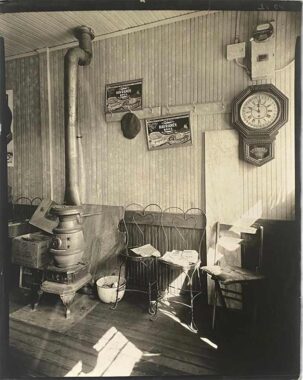
Though Abbott concentrated mainly on Manhattan, she worked all over the city. Featured in the book are a pair of photos she took in Spuyten Duyvil in scenes that have utterly disappeared today. If she had taken a photo of the exterior of this country store whose address was at #2553 Sage Place, it isn’t in the collection. Yet, more evocative photos of a lost era can’t be found. Noon sun streams in and falls on a wood plank floor. The room is warmed by a pot belly stove (you can still find one in McSorley’s on East 7th Street today). A ticking wall clock records the 11:50 AM time. On the wall are a pair of ads for the Havranek Brothers retail meat business. The Havranek Brothers were Czech immigrants who sold meat in Yonkers from 1920-1949, and the business, surprisingly, is well-archived online.
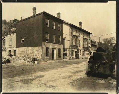
Abbott chose to shoot these three 3-story buildings on Ewen Avenue, likely the same day as the country store photo. One of the houses is anchored by a bar and grill, and two wood barrels can be seen in the alley beside it. A hill to the rear probably separates the street from Marble Hill, the only neighborhood in Manhattan on the mainland. Ewen Avenue remains a dirt road, but the truck at right could be an asphalt paver.
As you can see on the Hagstrom map I cropped above, there were three streets located east of Johnson Avenue in Spuyten Duyvil in the early to mid-20th Century and likely before that. Until Google Maps and Open Street Map, Spuyten Duyvil was notoriously sketchily mapped by Hagstrom, Geographia and other mapmakers, perhaps because surveyors found it difficult to access the semiprivate roads. In 1923 G. W. Bromley published a map that shows Ewen Street as well as other area roads, but not Leyden Place or Sage Place. By 1938, the era Abbott took her photos, Bromley was showing the trio of streets, though not the same way the Hagstrom shows them.
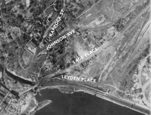
Which mapmaker was correct? In this 1924 aerial survey, Hagstrom may have been more on the money. It shows a triangle street layout, as does Hagstrom. I forgot to identify Ewen Street here, but it’s that brighter streak just east of Leyden. There are some scattered houses along Sage, and one of them may have been our country store.
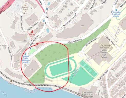
In the late 1960s or early 1970s, the streets were expunged from the map. Currently much of the area is occupied by the campuses of John F. Kennedy High School and Bronx Theatre High School and their athletic facilities. The schools are accessible from Marble Hill.
In “History in Asphalt,” first published in 1978 and revised since, the late Bronx historian John McNamara lists Ewen, Sage and Leyden in the current Bronx streets section. Ewen Street was named for Civil War general John Ewen, who fought in NY State’s National Guard, participating in the Battle of Gettysburg. He later was elected NY City Comptroller. The name is still in use at Ewen Park a bit north of here. His daughter Eliza donated the parkland to the city in 1916, but it wasn’t opened as a park until 1935. Spuyten Duyvil and Kingsbridge are not park-starved as Ewen, Henry Hudson and Seton Parks take up a lot of green space, dwarfed, of course, by Van Cortlandt Park, NYC’s second-largest park, surpassed only by Pelham Bay Park.
Leyden Place, meanwhile, was named for Leyden, Holland; In Marble Hill, West 225th was formerly Leyden Street. Both names have disappeared from the map. Sage Place was named for the long-razed Warren B. Sage mansion, which later became the Edgehill Inn.
Check out the ForgottenBook, take a look at the gift shop. As always, “comment…as you see fit.” I earn a small payment when you click on any ad on the site.
1/16/26
3 comments
Just to the east of the LEYDEN PLACE label on the 1924 aerial survey, you can see a curving line sweeping north. That is, I believe, railroad tracks, which were visible for a long time from Metro North trains until quite recently. They ran (run?) in a narrow slot between the foundation of the Promenade Apartments and the green athetic field on the modern map. I wonder where they go to. The one time I walked in Marble Hill, maybe 10 years ago, looking down into the valley at the north end where the creek used to be, there was an old industrial-looking building. It must have been served by that railroad spur.
Based on curvy property lines, looks like the spur may have served what is currently the large U-Haul building on Marble Hill Ave
Wouldn’t the hill behind the three Ewen buildings be the Spuyten Duyvil hill, not the Marble Hill one? The sun is making shadows from the south, as it would be if the buildings were on the west side of Ewen, with Sage and Johnson behind them. I don’t know, it’s complicated geography up in there.