

WHAT is now called Shore Parkway was constructed as the Circumferential Parkway in 1940 but the official name was changed, soon enough, to Shore Parkway to the delight of sign and map makers everywhere. Along with the Laurelton and Cross Island Parkways, it makes up the Belt system of parkways partially ringing Brooklyn and Queens. In Brooklyn and Queens, from Owls Head Park to where the Laurelton Parkway meets Sunrise Highway in Laurelton, Queens near the Nassau line, its service roads are invariably signed by the Department of Transportation as Shore Parkway, and its few residential addresses are also called Shore Parkway. Google Maps calls the actual parkway Belt Parkway and its service roads Shore Parkway.
…Except on the south side of Cropsey Avenue, at the Shore Parkway westbound entrance ramp, where we find this Belt Parkway sign. Since I know of no others (I’d have to walk all of the service roads in Brooklyn and Queens) I’d have to assume this is a mistake on the part of the DOT sign shop.
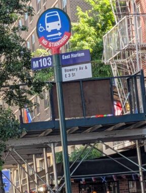
It’s not like there aren’t other signage errors around town. This bus stop sign refers to a “Bowery Av” and precisely no one has ever called the Bowery “Bowery Avenue.”
A few years ago, I found a “Long Island Expressway” sign in Sunnyside. In that part of town, I-495 is called the Queens Midtown Expressway, and from Queens Boulevard to the city line, the Horace Harding Expressway. Only when it crosses that undefended border into Nassau is it known as the “Long Island Expressway.”
Check out the ForgottenBook, take a look at the gift shop. As always, “comment…as you see fit.” I earn a small payment when you click on any ad on the site.
6/4/26