

I walked a great deal from August through early November 2025, and a good thing too, since I have had mobility issues since; who knows if those 5 hour, 10-mile walks are done for good (I walk slowly even at my best, stopping often to shoot things with a camera). I walked the entirety of Driggs Avenue in Williamsburg and Greenpoint over two separate walks in October and November; I had done it years previously, but in dribs and drabs, and things change in the city much faster than they used to. Walking is why I live, and I hope I can get back to a reasonable schedule. Also, because of cold and snow, I have done just two such “camera walks” in 2026. In my 40s, I thought nothing of going forth in 20 degrees and wind.
First a bit of context. Driggs Avenue is unusual, in that its house numbering runs east to west, in contrast to the majority of NYC streets oriented west-east. Thus the lower house numbers are in Greenpoint, the higher in Williamsburg. The street is named for Edmund Driggs, the last village president of Williamsburg before it briefly became a city in 1855, only to be absorbed into the city of Brooklyn. His son Edmund Hope Driggs was a two-term NYS Representative from 1897-1901. Until many of Williamsburg and Greenpoint’s street names were changed in the 1890s, the Williamsburg section of Driggs Avenue was 5th Street, and the Greenpoint section was Van Cott Avenue, for a local farming family. The Williamsburg section changed to Driggs first, then the Greenpoint. See this 1858 Dripps map of this section of Kings County.
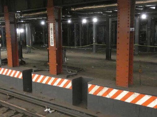
The trip actually begins in Manhattan. I took an F train to Delancey and changed to the J to get across the Williamsburg Bridge. While waiting at Essex Street, I checked on the former trolley terminal on the south end of the station, in use from 1908-1948, which I noted in this FNY post from 2023. There was once a plan to turn it into a below-ground version of the High Line, but in a more compact space, but the pandemic put an end of lots of grand plans. I doubt it would have been built, in any case.


The first stop in Brooklyn on the elevated J is Marcy Avenue, one of the oldest stations in the subways having opened in 1888, and the views are prime especially looking west toward the first Williamsburg(h) Bank Building (I’ll get to it presently), the side of the Peter Luger Steakhouse building, and the bridge. A recent addition is One Domino Square, where the penthouse recently sold for $7 million. Views cost money!
Walking toward Driggs on Broadway you are in Deep Brooklyn, unpainted pillars, grunge, honking horns, the whole nine yards. Broadway, from Kent Avenue to East New York, was the site of ForgottenTour #1 on June 1, 1999. This is a distance of between 5 and 10 miles, and our group, which included Frank Jump of Faded Ads fame and Jeff Saltzman of NYC’s original streetlamps website, cheated a bit and rode the J between Flushing Avenue and Halsey Street, walking the rest of the route. My intention soon is to cover the “uncovered” section of Broadway between Kent Avenue and the bridge, which I have not detailed for several years.
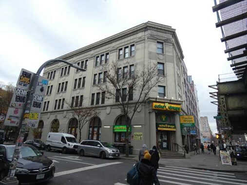
The building on the SW corner of Broadway and Havemeyer, now a drugstore, is a former Bank of Manhattan building; there was formerly a huge neon sign on the roof to greet J train riders. The front entrance is interest because of a pair of Ionic columns. The upper floors house the Shriver Tyler MacCrate Center for Justice, which “provides comprehensive legal services for Brooklyn residents, including housing advocacy, immigration, benefits, and support for community groups,” notes the Coalition For The Homeless. One of the honorees in the name is Sargent Shriver (1915-2011), co-founder of the Peace Corps and vice presidential candidate in 1972.


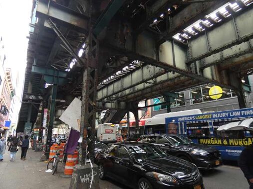
I have had a fascination with the elevated connection between the Broadway elevated and the Williamsburg Bridge. The bridge opened to traffic in 1903 (most traffic was horses and carts that year) and streetcars and an elevated train connection to Manhattan were added in 1909. The railings on the connection are unique in the city and are unchanged since that year. The area beneath this spur was originally a trolley car storage and turnaround area, but now serves the same purpose for buses.
The Broadway el was originally built all the way west to connect with a ferry to Manhattan accessed from Kent Avenue (meaning all of Brooklyn’s Broadway was completely obscured by an elevated railroad), but that spur was closed when the ferry did in 1916 and was dismantled soon after. Some of the supportive structure can still be seen, but it’s obscured behind a very wide ad billboard.


Soho in Manhattan isn’t the only place in NYC where you’ll find a group of castiron-front buildings (invented by James Bogardus in the 1840s). Brooklyn’s Broadway also has a few, and some that resemble them, between Kent and Marcy Avenues, including this beauty at #240. It has only been whitewashed the last few years; the 1980s tax photo shows it as it was for decades: increasingly rusty. The ground floor is currently untenanted. According to architects Mancini Duffy, it was built as a sewing factory in 1910.


I’ll get to Driggs Avenue soon but I did want to check in on the old school 1960s-era signage at Roebling Pizza, established in 1960 at this hole in the wall location, #326 Roebling between South 9th and Broadway. According to Yelp, it’s the 7th-oldest pizzeria in NYC. The reviews are almost uniformly good but it’s hard to get a bad slice here.
Roebling Street was named for the architects of the Brooklyn Bridge, John, Washington and, it was later revealed, Emily Roebling. Washington’s wife Emily assisted in the Bridge’s construction when her husband (who had taken over the project from his father John, who had died of tetanus when his foot was crushed during construction) was himself struck down from caisson disease acquired when he was working beneath the East River bed and nitrogen entered his blood vessels. He then observed construction from the Roebling’s house in Brooklyn Heights with a spyglass and had Emily relay instructions to the construction workers. From her close association with her husband’s work as well as her own education, she knew engineering principles and with his help, she was able to explain his instructions to engineers. Emily had her own plaza beneath the Brooklyn tower dedicated a few years ago, seen on this FNY page.
Before the Roeblings were honored by this street it was simply called 6th Street. North-south Williamsburg streets were numbered till the late 1800s, and east-west streets were also numbered in a North and South sequence on either side of Grand Street. No doubt this led to confusion which led to the north-south streets obtaining names: Kent, Wythe, Berry, Driggs et al.


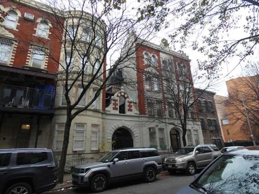
I was initially stumped by this building at #185 South 9th, till I consulted the Belcher Hyde Brooklyn desk atlas (1929) discovering it was built as the Immanuel Evangelical Lutheran Church. In recent years, it has served as the Light of the World Pentacostal Church but that, too, has moved out. Perhaps co-op conversion awaits. An exterior description reveals the church was constructed in 1894 and rebuilt in 2001.
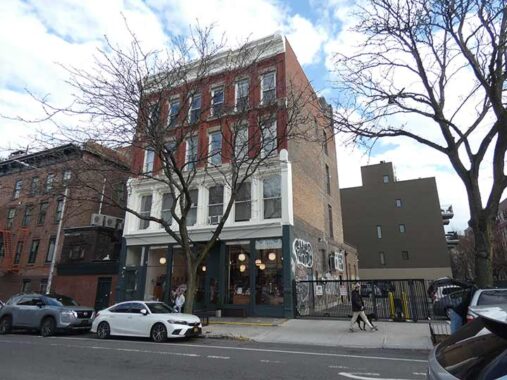
I’d be more in favor of the relentless push for more housing in NYC by advocates if the housing they had in mind looked like this, at #876-882 Driggs, three attached buildings at South 9th built as a unit. Look at that elaborate entrance arch and bayed windows!


The incredible domed Williamsburg(h) Savings Bank, at Driggs and Broadway; when it was built, Williamsburg had an “h.” Built between 1870 and 1875 by George Post, this was the Savings Bank’s headquarters until 1929, when Brooklyn’s only skyscraper was constructed at Hanson and Ashland Places in Fort Greene…so the Williamsburg Savings Bank, now HSBC, has built two of Brooklyn’s signature buildings. It was restored in the 2000s by designer and artisan Peter B. Wight and now serves as the Weylin event space, whose website vouchsafes a peek at the sumptuous interiors.
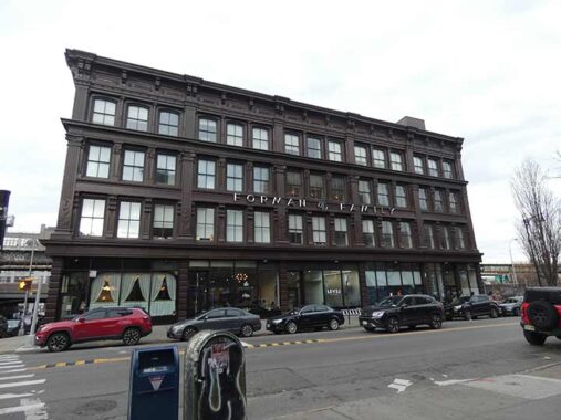
FNY covered the mighty Forman Building, NE corner of Driggs and Broadway in September 2025, but there’s some things I didn’t talk about…


I did mention the cast iron calla lilies, but not the “B-Way” and “Sixth” signs on the corner. Thus, the building, constructed in 1883, was between the time the north-south streets received names and when the east-west streets did (this stretch of Broadway was once South Sixth). OCD people will object that the architect created the apostrophe backward.
Speaking of the Formans, metalware man Sol Forman and partner Seymour Sloyer also purchased Peter Luger’s steakhouse for the bargain price of $35,000 in 1950 after the cafe, founded by Carl and Peter Luger in 1887 and succeeded by Peter’s son Frederick Luger, had fallen on hard times. Sol Forman lived to age 98 in 2001, and his and Sloyer’s descendants continue to run it as a premier steakhouse today. I have enjoyed the fare twice in its Brooklyn location and once at its Great Neck branch. Make reservations and bring cash or a bank card.
I stopped in long before I had a meal. In December 1993 my friend Vinny and I were driving around northern Brooklyn, possibly priming for my Forgotten NY work, when we stopped in just to see what the place looked like. We had a beer at the bar around noon and were fascinated as the meat deliveries were arriving and guys were hustling about carrying piles of raw meat on trays.
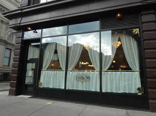
The Forman Building was designed by architects Herman J. Schwarzmann and William Ditmars for shoe merchants James R. Sparrow and James R. Sparrow Junior, and the restaurant opened on the corner space at Driggs was named for the long-ago occupants.
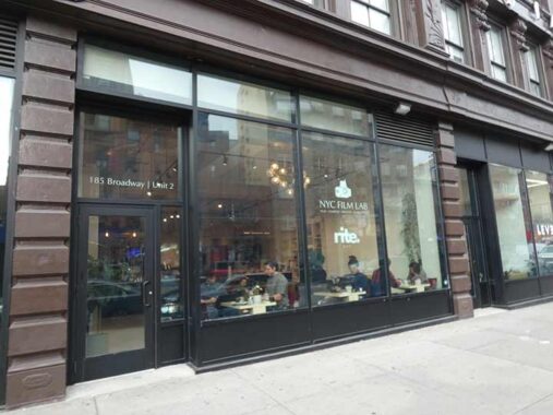
I stopped using camera film quite awhile awhile ago, but many professional photographers still do, and vouch for its superiority; this NYC Film Lab in the Forman Building sees to their needs. ( I think kodachrome and ektachrome provided the richest color. On this cloudy day, though, color was at a premium.) The lab shares space with rite. coffee, hence the tables and chairs.
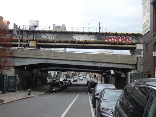
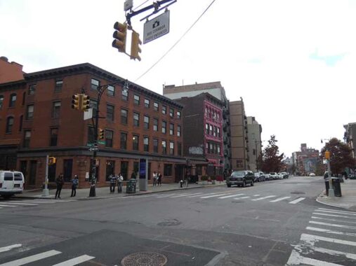
Driggs Avenue is spanned three times between Broadway and South 5th, by two traffic lanes of the Williamsburg Bridge and in the middle, the trestle carrying the elevated RR.
I have a fascination for this tiny building with arched windows with an even address, #800 Driggs, between South 4th and 5th. We are not in a landmarked district so details are not immediately available.


As I write this on “Pi Day” (3/14) I note that the longtime Williamsburg Southern joint, Pies ‘n Thighs (as in chicken thighs) emblazoned its name on a column vent at Driggs and South 4th. I’m a pie guy but I don’t want to aggravate A1C.
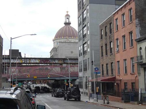
A look back, toward the ever-photogenic Williamsburg(h) Bank.


The NW corner of Driggs and South 4th features a bicycle shop called Sun and Air, with striking pink color scheme and typography in Franklin Italic. Preceding it on the corner until 2015 or so was the equally striking Diaz Cleaners sign with woodcut lettering including a script lowercase “z” you don’t see often in store signage.


“The Stradtman,” #728 Driggs at South 2nd Street. It’s not unusual for a builder to use their given name for a property, but adding “The” in front of it is rarer. The building likely dates to 1917, as a NY Times listing has it in “new incorporations”:
Henry Menken Realty Co., Inc., Brooklyn, real estate, $50,000; A. Stradtmann, H. and E. Menken, 728 Driggs Av., Brooklyn.


As I suspected the peaked entrance at #726 Driggs, between South 1st and 2nd Streets, is a recent addition. The building has been a house of worship for some time: in 1940 it was a Jewish temple.
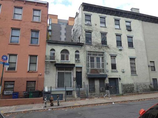
New and old buildings mix liberally in Williamsburg where the North and South numbered streets adjoin. This handsome partially ironclad building at #705 Driggs is just north of South 1st Street.


In 1940, Whalen Brothers Furniture dominated the NE corner of Driggs and Grand Street. The new building on the corner, #225 Driggs, constructed in 2011, was built to echo the previous building on the site. In the older photo, there’s plenty of evidence of the old trolley lines, with iron poles carrying overhead wires. (In Manhattan, these were outlawed and streetcars took power from conduits under the streets.)
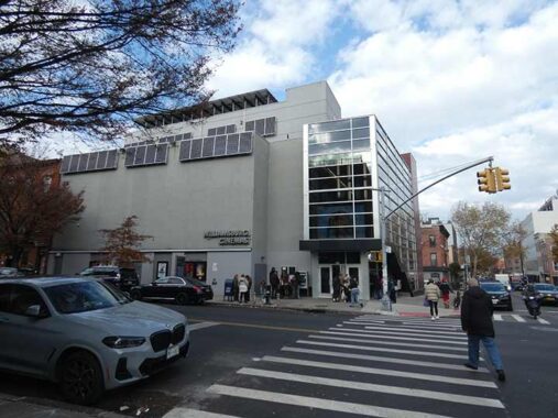
If I asked you to guess what’s the purpose of this building at Grand Street and Driggs Avenue, “movie theater” wouldn’t come to mind, but this is actually Williamsburg Cinemas, built in 2012. I’ve never watched a flick here, but I do encourage neighborhood movie theaters, which are a dying breed. I actually have started attending more movies since summer 2025, of varying quality; I usually attend midafternoons during the week or on Sunday. I thought “Undertone” (March 2026) was a snoozer, but I like the dark room, big screen and the popcorn (actually good for digestion, if you don’t use too much of the fake butter).
There are major Grand Streets and Grand Avenues in Brooklyn and Queens, and the Grand Concourse in the Bronx, and of course Grand Central Terminal and Grand Central Parkway (which have nothing to do with each other). “Grand” can mean “large” in a mostly archaic sense, but most often used to mean “important.”
We are now in the North numbered streets. Looking west on North 1st is a new luxury residential building cryptically called I7INI, built by architects PAX BKN, which translates to #171 North 1st. It does have large picture windows, but they only have views of the south side of the street.


New Yorker Millard Fillmore, who bears a strong resemblance to present-day actor Alec Baldwin, was the second president who was not directly elected to the office, taking over for Zachary Taylor after the later’s death. He was pro-slavery and Nativist, in contrast to the abolitionist-sympathizing Taylor.
Brooklyn has two streets purportedly named for him, the Landmarked Districted Fillmore Place, one block in Williamsburg between Driggs Avenue and Roebling Street, and Fillmore Avenue, one of the few named streets in number and letter-dominated Marine Park. Fillmore Street in Morris Park, Bronx appears alongside streets named Garfield and Taylor. On this 1858 map, Fillmore Place shows up as North Street.
There are no Fillmore Streets in Queens, but there is one of my favorite restaurants, Millard Fillmore’s near Queens College. Get the blackened meatloaf. Staten Island checks in with Fillmore Avenue in Willowbrook, Fillmore Place in Rosebank, and Fillmore Street in New Brighton.
Long ago I did a detailed “shoot” on Fillmore Place, but it seems to have been lost, so above is a sampler of its uniform mid-19th Century buildings. At the Roebling Street end is a mural by popular street artist Snoeman. I had previously found a mural by him on a 2025 walk in Inwood.
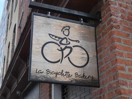
Bakery shingle, Driggs at Fillmore Place. Thee handcrafted signs can be a little twee for my preference, but I like most of them anyway.
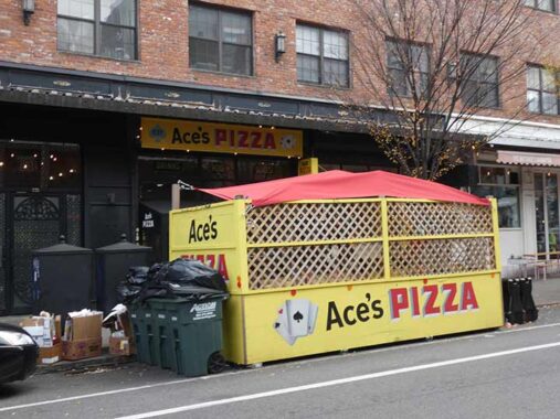
On a previous jaunt, I sampled Ace’s Pizza, #637 Driggs, and found the fare (Detroit style, with thick base and sauce on top) worthy of praise, and the owner friendly. Recommended. The store signs bear the hallmarks of Noble Signs, and is featured on their website. Ace’s also has a branch in the Rockefeller Center underground passage, and another on Jackson Avenue in nearby LIC.
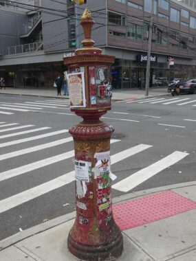


Severe deterioration of the paint job done on this fire alarm done by firefighter Dave Herman here, whose City Reliquary is a must-see Williamsburg attraction at 370 Metropolitan Avenue. It seems fitting that there is, or was, a decorated firebox here, since Driggs, among other things, was the Williamsburg City Fire Insurance Company president.
#178 North 5th/#604 Driggs began as Royal Machine and Stamping Corp. factory and was converted to residential several years ago. As FNY readers know, I like brick factory conversions; my own complex in Little Neck was built as garden apartments in 1941, but partially modeled on this template. On the exterior you can still see much faded white identifying lettering.


At #584 Driggs between North 5th and 6th is what was apparently originally the St. Vincent De Paul Clubhouse, associated with the church on North 6th. By 1940, it sported a banner proclaiming it as “CYC” (Catholic Youth Club”?) In 2025, much stripped of its old details, it was Unity Preparatory Charter School of Brooklyn, a 6th-12th grade prep school.
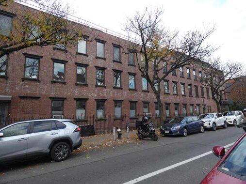
The St. Vincent De Paul parish school later became St. Francis Prep (which moved to Fresh Meadows in 1974) and later, Boricua College. The church building itself, which dates to 1869, was sold to developers in 2011, who kept the building standing and converted it to residences.


North of North 6th, Driggs enters a commercial district, though not the match of the bustling Bedford Avenue scene a block west. The “High Society” storefront drew the camera’s attention; its website describes it thus:
At Grab & Go in Brooklyn, New York, we’re more than just a corner store we’re part of your daily routine. Conveniently located at 555 Driggs Ave, we offer a place where you can find everything from snacks and drinks to hookahs, bongs, and ice cream.
Yes, folks, bongs and ice cream. A pulse on Williamsburg priorities, I suppose.
This section of Williamsburg was once called “Northside,” with Southside in the South numbered streets south of Grand Street.
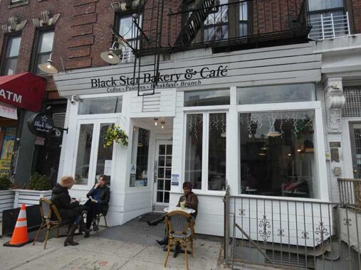
It was still mild enough in November for a cup outside at Black Star Bakery & Cafe, #548 Driggs. The subsequent winter turned out colder and snowier than usual. From my Photo Lettering days, I knew the sign font (which screams 1970s) and Bookman JF Italic. At PL, all fonts were assigned four-digit numbers. Helvetica, of course, was the most employed one.
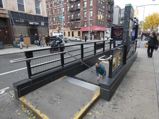
The west end of the Bedford Avenue station stop on the BMT Canarsie (L train) lets out there. Just this morning as I write, I heard a report that this is the busiest stop in the subways on weekends. Plenty of tourists sampling the wonders of Williamsburg! Until the 1990s, The Willie was a dodgy backwater.
A few years ago, this was one of the grungiest stops in the system, but it got a makeover, complete with snazzy new entrance steps. Plenty of remaining stations need work including BMT Chambers (the worst) and surprisingly, West 4th IND (one of the busiest).
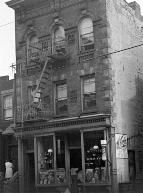


I have checked on this building, #539 Driggs, just north of North 7th, since at least 2009. On my latest pass, it remains unchanged. In the dim past Nittoly’s Barber Shop, seen in 1940, occupied the ground floor (the remains of the revolving striped barber pole remain in place). The house is still owned by James Torpey, 78 years old in 2025, who I would love to talk to sometime.
#510 Driggs, at North 8th, is not much to look at (IMO) but it’s better than a parking lot or empty lot, which it had been for years, and before that a garage.


Moving on to North 9th, the camera focused on this seemingly old school neon sign for “Organic Planet and Pharmacy,” which implies that they sell planets. I josh. Smoothies are also sold in addition to pharmaceuticals, harking back to the former practice of including ice cream counters in drugstores. In any case it’s in a new residential building called “The Driggs” that fronts on North 9th and the pharmacy has held down the corner since 2014.


On the west side of Driggs between East 9th and 10th is one of its most extraordinary buildings (but not the most; see below). The 1929 Belcher Hyde atlas labels it only as a “loft building” but it’s one of those simple brick and windows buildings I think is so attractive. It has been converted to residences, with retail on the ground floor.
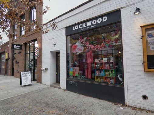
On the east side of Driggs between East 9th and 10th, Lockwood is a stationer originally based in Long Island City. We saw a long-gone barber earlier, so here’s a new one, Driggs Barber, complete with striped pole, which opened in 2025. In a new trend at man’s barbers, liquor is on offer.


#444 Driggs/#183 North 11th, another classic brick building, was once a paint factory as shown on the 1940 Municipal Archives photo. It too is now residential, with an entrance to Northpoint Photo Studio.


I mentioned the most beautiful building in Williamsnburg and here it is, at the northern end of the neighborhood. To me it edges out the Williamsburg Bank Building seen earlier. The Byzantine Russian Orthodox Cathedral of the Transfiguration at Driggs Avenue and North 12th (built 1916-1921) has five onion domes, four arranged around the central dome in a Greek cross. The church claims it to be the one and only representative of Byzantine Revival architecture in New York (though there are other onion domes scattered around town). The church offers services in English and Slavonic. Louis Allmendinger, a prolific and all-purpose architect, also designed the utilitarian last edition of the Gustave Mathews Flats on Grand Avenue on the Maspeth-Elmhurst border.
The cathedral has some interesting plaques, with info about St. Vladimir, with news you can use: Russia was converted to Christianity in 988. Many churches are dedicated to the Transfiguration of Jesus, an episode in three Gospels (excepting John) in which Jesus is revealed in His full glory as God, appearing in radiant light with two Biblical figures, Moses and Elijah (Elias in the Douay Bible).


North of North 12th, Driggs Avenue passes through McCarren Park but I did not tarry, it was getting late. McCarren Park is the sine qua non of northern Brooklyn parks. It was developed between 1903 and 1905 and is named for Patrick McCarren, state legislator & Williamsburg Bridge promoter in the late 19th Century. At 35 acres it ranks among Brooklyn’s larger parks, and boasts a Depression-era public swimming pool (reopened in 2012 after years in ruin) and an Olympic caliber running track.
I check on certain buildings every time I am in these parts, such as the Royal Lace Paper Works building on Lorimer facing McCarren Park off Driggs. Not quite sure of the last years of Royal’s existence, but one of their more popular products was Royledge shelf liner, used to create decorative borders on shelf edges. “Lace paper” describes a variety of decorative paper products resembling lace. Paper Lace, of course, recounted “The Night Chicago Died.“


Bernie’s, at the corner of Driggs and Lorimer, has had some management and name changes over the years; when I was here in 2009, it was the Park Luncheonette. The latest management, though, has elected to retain the “arciform” Coca Cola sign and distinctive lettering. Coca -Cola bottlers offered these “privilege” signs to shopkeepers in return for prominently displaying the Coke sign. You can still see dozens of these old-school sign around town; they do their job clearly.
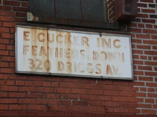
I always check on this sign, too, on Driggs Avenue next to Bernie’s. The name sounds like something else.
“According to a story in DNAinfo published in 2013, customers at the diner, for many years occupied by Park Luncheonette and now known as Bernie’s, complained about ‘feathers flying in customers’ food from the feather factory,’ a problem that had existed for nearly 35 years.” [Brownstoner]
Coming soon: Driggs Avenue in Greenpoint
Check out the ForgottenBook, take a look at the gift shop. As always, “comment…as you see fit.” I earn a small payment when you click on any ad on the site.
3/21/26