The Bronx is the only mainland borough in New York City, and in the golden age of railroads it had plenty of freight and passenger routes that served upstate New York and New England. On this page, we’ll take a peek at one of those lines, the Harlem River Branch, which still has station houses waiting for trains that will never arrive again.
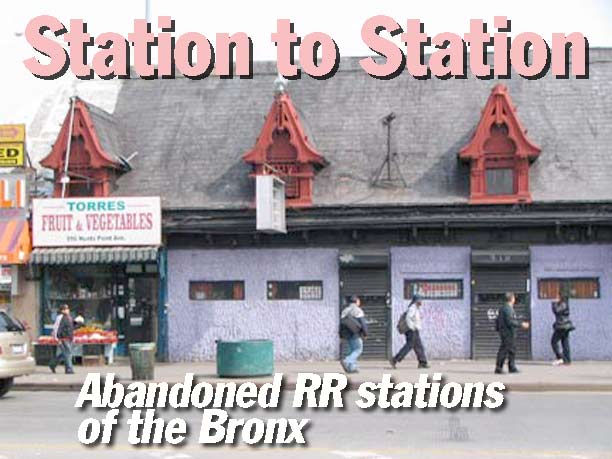
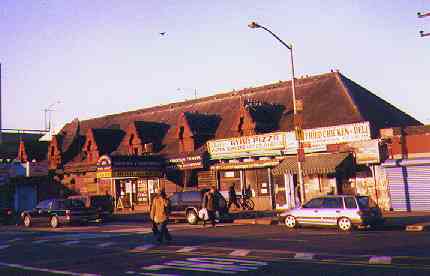
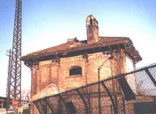
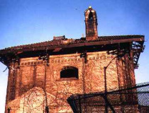
The southernmost extant station of the NY, NH & H is the Hunts Point station, on Hunts Point Avenue near the Bruckner Expressway. Most of the station is intact, including many of its peculiar architectural traits.
The Hunts Point station today is home to a variety of businesses… a deli, a pizza place, a travel agency, and a topless joint.
According to NYC subway and railroad historian Joe Brennan…
The New York, New Haven and Hartford made its entry to New York via the Harlem Line in 1849, but the secondary route known as the Harlem River Branch was opened in 1868 mainly to make freight connections by water with other railroads. Local passenger service was also run until 1931. The line was rebuilt in 1908-1910 to 6 tracks with complete grade separation, and all new stations. It was also electrified. Most of the branch became part of the Hell Gate Route opened in 1917, the main line from Penn Station to Boston, and so it still has intercity trains today run by Amtrak. The portion south of 142d Street is now open for freight only.
(Footnote: From 1876 to about 1906, two passenger trains a day on a Boston-Washington run were carried by lighter (a barge with rails) between the old Harlem River terminal and the Pennsylvania Railroad at Jersey City, without a New York station stop. That unusual operation was then replaced by an inland route over the Poughkeepsie Bridge, and the trains were finally included among those using the new Hell Gate route starting in 1917.)
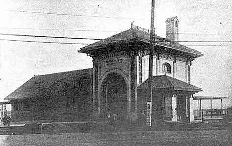
Exterior and interior of Hunts Point when it was receiving passengers, probably until 1931. It had dormer windows and a crenelated roof. The roof spires and crenelation are now gone.
All older pictures on this page courtesy Joe Brennan.Photos from Roger Arcara’s ‘When the Westchester Was New’. They are from Railway Age Gazette, 28 January 1910, except the Hunts Point interior is from same, 4 February 1910.
The dormer windows are mainly haunted by pigeons these days, though one still has a window, and another still has a spire.
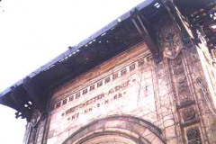
One of the features common to stations on the NY, NH & H that I saw was a diamond motif, which is repeated on the exteriors and interiors of the older pictures I was sent.
At Hunts Point, the diamonds on the exterior are all flanked by two stylized fish. I’m unsure why.
One of the modern uses for the Hunts Point station.
As it happens, the next station to remain standing is the very next stop on the NY, NH & H, the Westchester Avenue station at Whitlock Avenue and the Bronx River. Note the tiny piece of roof crenellation that has survived the years.
Westchester Avenue station in the 1910s. Most of the station house still stretches over the tracks as it did until passenger service was abandoned in 1931.
Westchester Avenue station dates to the late 1890s-early 1900s and features a lot of the ornamentation that marked public buildings at this time, with foliage, torches, wheels, and a mysterious target-like device.
The top of the stylized torches bear the letters NYH, which probably stand for New York and Hartford.
The station is still marked clearly. Surprisingly none of these metallic letters have fallen off over the decades.
(click for larger image)
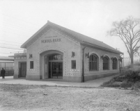
Morris Park, at Sacket and Colden Avenues, has also had its canopy taken away in intervening years. Even when it was still in business, Morris Park was probably a pretty quiet station.
Note the diamond motif at what must have been the old ticket office.
Morris Park featured large picture windows. Of course they have long been bricked over and graffitied.
photo: Don Gilligan
There is one more abandoned station on the NY, NH & H in New York City, in the City Island Road station.
According to Brennan:
The brick stationhouse stands in ruins in the woods a short distance S of the road from the Hutchinson River Parkway to the City Island circle. It was also known as Bartow. This lonely spot was the transfer point for the trolley to City Island, which started here, so it rated a good station. To see it, start at the Pelham Bit Stables parking lot on the southbound Shore Road, and walk N along the bridle path. Just before the road to the Parkway, take an overgrown paved path W to the station. Warning: the bridle path is quite active; walk along the edge, but let horses and riders see you. Warning: the golf course parking lot to the north is a little closer to the station, but the walk requires a dangerous crossing of the road to the Parkway. At the station, please do not go onto the tracks: high speed Amtrak trains approach around curves from both sides.
Christopher Gray reviews the stations in this November 27, 2009 NY Times article.
3/1/01









10 comments
My father started as a teenage messenger for the Old Colony Line at Pier 17, East River.When the latter was absorbed by the NYNH&HRR, he thus began a 60-year long career with them, ending up as the NY to Portland, ME freight superintendent in New Haven. Most of his career, however, was at the former NH Harlem River freight yards as a clerk and later on, prior to moving to New Haven, as manager of piggyback, float, and barge operations.He was pretty handy with his dukes, which he used regularly at a facility loaded with guys named Brannigan, Zugalla, Duggan, Walsh, O’Connor, Cronin, Connelly who always carried a beef about someone’s religious background not their own. I have a number of b/w photos of the operations which took place at Harlem, both on the water and on land, including–at that time–the yearly unloading of the Barnum and Bailey circus and its parade over the Willis Av. bridge to Madison Sq. Garden.Are you interested in these, no strings attached?As I’m now older than my Dad when he passed, I’d be happy to find a home for the photos; if not, I guess they’ll be tossed out./ Albert J. Silverstein
If by chance you still have those pix, I would love to have them. I grew up behind the yard. The arrival of the circus train was a major event, eagerly anticipated by all of us kids. We swam off the lighterage dock under the Willis Ave. Bridge. I had my first paying job in the freight house that ran under the bridge. I went there one day with one of our tenants who had worked there. One of the businesses was unloading box car of priting paper. I wheeled hand trucks out of the boxcar into the freight house. I was paid $5.00. I was about 10 years old.
Mike Conlon
I lived in the Morris Park section of the Bronx from 1962 to 1979, when I was between 9 and 26 years old. As kids we used to go to the Morris Park station house shown in this article. It was bricked up even then but we would poke around, walk along the tracks and wait for trains to come by.
There used to be also a number of pedestrian crossings of the NYNH&H RR tracks between White Plains Road and Rosedale Ave. They were dilapidated then and at some places you could see the tracks below through the broken pavement, so it was “daring” to walk across. Eventually the bridges were closed for obvious safety reasons and may no longer even exist. I read that recently the commuter lines are thinking of starting service again on this route and would have to rebuild some of what they neglected and allowed to disintegrate over 75 years.
I Love to read comments such as those above about the NYNH&H, Putman Division & long gone LIRR right of ways. It must have really been something to see way back before the turn of the millennium century. I had an Aunt & Uncle that lived in the Baychester area of the Bronx and remembered when there were still actual “abandoned stations” with remaining sections of platforms and station houses along the route. They bought their house back in the early 50’s. The Baychester station used to exist past where the Highway crosses over the line. If you watch the movie “The Seven Ups” from the early 70’s starring Roy Scheider there is a scene that takes place near the finale of the film where they do a stake-out next to the Northeast Corridor that is literally 2 short blocks away from where my Uncle & Aunt lived in the shadow of Co-op City. In one scene you see what looks to be an old station across the tracks which was according to my Uncle the long-gone Baychester station house. They quietly raized the building and whatever remained of the low level platforms that still existed up until almost 1980. Passenger trains as well as Freight trains ran very frequently even more so back then. I used to see a lot of Dual Engines with the insignia “Penn Central Railroad”, “New Haven-Hartford” & “ConRail” on them go by and Amtrak was brand new (They started running in 1970). They spoke about a time before Amtrak even existed! I remember always hanging out & cautiously exploring that same area by the tracks as a small kid with some of my older cousins. At that time there were no fences or anything so you could literally walk right onto the tracks! To this day there are still areas near the New England thruway where access to the railway is totally open. Extreme caution is advised as Amtrak-Acela High Speed trains now run this route and you don’t want to get caught in sight of those or it will probably be the last that anyone will see of you. My Uncle told me he had photos from before they cleared the land – the Northeast Corridor line along this section of the Bronx was a 4-Track configuration and you can clearly see that still today even though some the extra roadbed was taken up probably decades ago now. There was a time when my cousins and I once walked the tracks back down to the Westchester Station on Eastchester Road. There were, at the time still platforms with old station signs that read “Westchester”. They removed all signage in the early 1970’s and you could easily enter the station from the street level staircase (there are gates there now). We also trekked up the tracks to the Bartow-City Island Station a time or two. We would normally walk the ROW on a really rainy occasion because there was less traffic on streets where the rails can be seen – and less chance of being seen by law enforcement that would make you exit the tracks or possibly arrest you. Those were fun times and I often wonder how different things look these days. I’m sure there is far less to see and many changes have taken place. My Uncle passed some time ago & my Aunt relocated afterwards to the Carolinas but I’m sure she still has those pics somewhere in one of their photo albums.
Wow im taken back. I grew up in the northeast bronx in the 90s and most ppl in the neighborhood except very elderly ppl woukd have little clue about such relics.
I watched the very end of the film and couod not pinpoint the demolished baychestet station house but my research points toward section 5 in co op city which i dont believe has some of those residential structures any longer. Would love to get more insight from you. Thanks.
I belonged to a fraternity whose house was on Van Nest Ave.
This was between 1963-65.
I remember on of those pedestrian bridges over the yards if you were walking toward Parkchester.
Daylight was okay,but at night you could step in a hole.
We used to.frequent Al’s on West Farms Square for Italian food.
Our frat house was upstairs from an old bocce club.
Bronx metro station at 183rd street and park avenue is gone, I lived a block away in the 50’s on Webster avenue. are there any pictures? Thank you
I would like to illustrate the railroad station at 183rd st. and Park avenue . I was a active beautiful station when I lived there in the late 40’s and 50’s. It had a waiting room with benches and a pot belly stove, platforms downstairs. We used to walk over to meet my Dad there when he would come home from work. it will try to reproduce the image I have of the station so photos would be helpful. Thank you so much.
The right-of-way under the first two stations you cite is six tracks wide, although only two are present now. The New Haven line used four at its peak. The other two were used by the New York, Westchester & Boston Railway from 1912-1937, which shared these stations until 1931 and used them exclusively until service ended in 1937. The Westchester, which was a New Haven Railroad subsidiary, terminated at the foot of the Bronx where passengers transferred to and from the Third Avenue El. It headed north through these stations and peeled off on its own four-track mainline to what is now the Dyre Avenue (#5) line from 180th Street to the Bronx-Westchester border. North of there, the NYW&B ran through Mount Vernon and split with one branch going to New Rochelle and Port Chester, the other north to White Plains. It was a remarkable engineering and architectural accomplishment, but didn’t survive the depression. More at http://www.nywbry.com and https://westchestermagazine.com/publications/before-the-metro-north-there-was-the-new-york-westchester-boston-railway/
I just have a question. It’s not about Railroads. Did anyone know a woman named Hazel Fleming who was born, raised & died on Hunts Point, Irvine Street? I’m telling my daughter about what a beautiful woman she wasbut I don’t have pics or anything to show her.