BY GARY FONVILLE
Forgotten NY correspondent
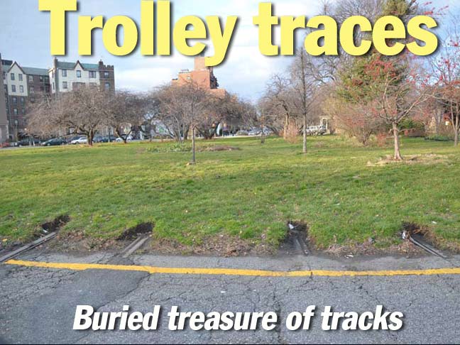
I used to live near this location where Coney Island Avenue meets Parkside Avenue in Kensington, Brooklyn at Park Circle. Even though I used that circle for 35 years or so, I never saw these former trolley tracks. Even ‘your webmaster’ didn’t see them when when he did a Kensington, Brooklyn piece recently. It’s just that inconspicious. It wasn’t until last winter when I was driving around the circle when the red light caught me. I just happened to look in the direction of these tracks. Bingo! I had my camera with me, went around the circle with camera ready and shot this photo. Generally, trolley route designations were transferred to the bus routes that replaced them. Since the B68 travels along Coney Island Avenue, these tracks serviced the #68 trolley route.
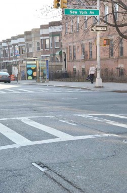
A while ago, I did a piece for FNY about exposed trolley tracks. Since that posting, many of those uncovered tracks have since been repaved. But you can see this one at St. John’s Place & New York Avenue in Crown Heights, Brooklyn. This photo was shot on St. John’s, looking east.
[That would be the #5 line, which ceased service 8/24/47]
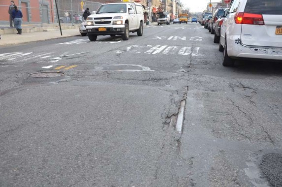
In a rare moment for me, I forgot exactly where I took this photo. But I do remember it was in Bushwick, Brooklyn. I think it’s on Wilson Avenue.
[The #14 Wilson Avenue line ran until 5/27/51]
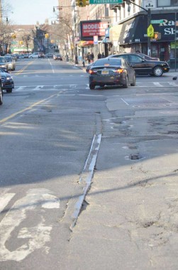
Church Avenue, looking west towards Flatbush Avenue. This route is served currently by the B35 bus route.
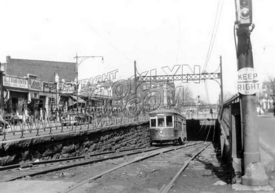
[Both the #8 and #13 lines used Church Avenue. The Church Avenue line was the last regular streetcar route in Brooklyn, lasting all the way to 10/31/56. The odd widening of Church Avenue for a couple of blocks either side of Ocean Parkway was for a trolley tunnel that ran under the Parkway. I wonder if it’s still there.] brooklynpix
9/30/12

35 comments
A little more on the B68 and #13: When the PCC cars (streamliners) were delivered in 1936, the B72 Smith St was merged with the B63 Coney Island Ave. The combined line was the B68 Smith St-Coney Island Ave. The line was re-split into the two lines in 1946 as B72 and B63. Through route reassignments between the trolley barns and bus garages, Smith St became B75 and Coney Island Ave became the B68. With the service cuts in 2010, the B75 was eliminated and the B 57 Flushing was extended from the area of Downtown Brooklyn to cover Smith St.
When the PCC cars were delivered, the Church Av line was #8. The #13 was Gravesend-Church. It followed today’s Church Ave line from Hegaman to McDonald, where it turned south. In 1930 it was combined with the 16th Ave line to 62nd St and 16th Ave, but was cut back to around 16th Ave and McDonald in 1932.
Have you ever come across any trolley traces on Staten Island? I’ve never seen any, they must have ripped out the tracks entirely back in the 1930s when the service was eliminated.
No, they were not all ripped out when service was ceased. They were just blacktopped over. Every so often they pop out to see the light of day when the blacktop has become weak and cracked. Have seen traces on Victory Boulevard, Jewett & Forest Avenues, Clove Road, Bay Street and Richmond Terrace. So just look closely at the streets when you are traveling. When you see two parallel cracks approx 4-/2ft to 5 ft apart (standard gauge was 4ft 8-1/2 in), then most likely that is where the tracks are hiding.
Dan, check out http://www.secretsi.com/tag/trolley
For Staten Island, not trolleys, but trackless trolleys, that ran along Arthur Kill Road between Richmondtown and Tottenville. The storage building is still standing at AKR and Cortelyou Ave. It’s now used by the Richmondtown Restoration for historic vehicles.
Trackless Barn
THX
The Church Av. trolley tunnel under Ocean Pkwy. was sealed up a long time ago. No visible traces remain.
The site was sealed but recently the MTA erected a building there.
Uhhh, no. You’re confusing it with the structure that was built at Avenue C and McDonald.
True, the tunnel is sealed up. However, I recall reading about 15 or 20 years ago an article in the NY Times that said the city was considering reopening the tunnel. I guess
proposition never came to fruition. I can still recall my excitement as a 4-yr. old going into that tunnel on the trolley. A mere 64 years ago!
I don’t have a photo, but around 1984 I lived in Bensonhurst on 82nd St. between 18th and 19th Aves. Along 18th Av, under the fence in front of the New Utrecht Dutch Reformed Church lawn, there was a single small piece of rail visible. This was the original West End Line before it was elevated around 1918.
Not exactly on point, but on the NE corner of Ocean Parkway & Avenue U Brooklyn is a metal thing (sort of like a huge old fire alarm) that I was told had to do with the trolley.
No.
https://forgotten-ny.com/2000/01/what-the-heck-is-that-thing/
It is the air vent for the sewage pumping station beneath that intersection.
[…] history of the Brooklyn commute know that our streets have been used for trolleys of all sorts. Forgotten NY has an interesting set of photos about various trolleys around Brooklyn including our very own […]
I am sure if you walked the circle near the tracks you would also find a concrete base. this was for the trolley signal lights when it was safe to cross through the circle. I remember it looked more akin to a subway signal than a vehicle traffic light.we rode the 68 at least once a week to visit my grandparents down town.
Have driven around that circle hundreds of times. But because I stay in the outside lanes, I never saw the rail tracks. Must go to the inside lane sometime, but it could take forever to get out of there.
Having been all over the world but a Brooklynite at heart I love coming to this site it reminds me of the stories I was told as a kid, every once in awhile shows me something I didn’t know or remember and always cures me of being homesick, which only happens about 3 times a day!
I posted a photo on the KARMABrooklyn Blog on September 9, 2012, of a small piece of exposed track by the northeast corner of Church Avenue and McDonald Avenue. It was visible again only two years after the most recent road resurfacing.
http://karmabrooklyn.blogspot.com/2012/09/tracks-uncovered-again-as-street-wears.html
What a shock to see those exposed trolley rails! Last fall and winter I was going out with a trowel every now and then, trying to do some archaeology without getting busted. I also excavated on the north side but the rails are too far below the ground level. I’m wondering if the rails go all the way through the circle or if they just left the last pieces embedded in asphalt.
When they installed the safety islands a couple of years ago the rails were exposed for a while then covered again. Keep an eye out for similar work or street resurfacing on former trolley lines.
I’ve built an N scale diorama of the Church Avenue/Ocean Parkway underpass and plan to do one of Park Circle as well. Alas, these are my only little pieces of Brooklyn as I moved to Detroit this year. Someone should continue the excavation of those rails…I’m sure they’ve filled up with debris by now.
on 20th street and prospect park west, some trolley rails are exposed..
You can also see some exposed trolley tracks outside the Brooklyn Main Post Office on Cadman Plaza East, at Tillary Street.
By far the biggest Brooklyn trolley relic is the old carbarn at 58th St. and 2nd Ave…three stories, capacity 1000 cars, the largest in the world according to some. Today it’s a warehouse with various small businesses using the space but the outside is intact, including the B.C.R.R. signs. I’ve heard (don’t quote me on this) that the owners will let trolley fans have a look around if they ask nice, and there’s some overhead cranes left over from the old days.
Another site worth seeing is the old trolley terminal in the Essex/Delancey subway station, where Brooklyn trolleys turned around after crossing the Williamsburg Bridge. You can see it across the tracks from the Brooklyn bound J train platform. The MTA is trying to market the space as some kind of “Low Line” and the Transit Museum has occasional tours.
I’ve heard that planned renovations to the new Times Square pedestrian plazas will reveal a lot of old Third Avenue Railway trolley conduit tracks. Anyone want to scout this out?
Almost all trolley rails were blacktopped over…the labor and road repair didn’t justify the scrap metal price. Even if rails aren’t exposed, you can often see ridges like varicose veins 4 ’81/2″ apart. Most lines had two sets of tracks right down the center of the street. Boarding passengers slowed up auto traffic…one more reason they got rid of the trolleys.
We lived on Nostrand Avenue between Avenues U and V in the early 1980s. I recall the old trolley tracks poking out of the asphalt that covered them. I also recall the tracks being pulled out when the city decided to scrape Nostrand Avenue down to bare earth before applying fresh asphalt. It had gotten to a point where the avenue could no longer be resurfaced with more layers of asphalt. The tracks lay piled up on the side of the road before they were hauled away. A sad sight.
The picture in bushwick is on Wilson ave between Putnam and Cornelia st. Across the street from PS 106 playground.
Weren’t the tracks along McDonald Avenue used jointly by the trolley line that ran along there as well as the South Brooklyn Railway (forgive me if I am not getting the name right)? I have seen pictures of new R46 subway cars being delivered, using the Bay Ridge Division of the LIRR and then the connection on to McDonald Avenue at Parkville.
Yes – they were used by both the SB RR and the trolleys until the end of trolley service 10/31/1956. There continued to be freight / car delivery service along McDonald Avenue between the Coney Island subway repair shops, the LIRR at Parkville Junction and then down to the Brooklyn waterfront along 39th Street for quite some time after then, using diesel power. There were even a few businesses along McDonald Avenue that were serviced by rail including one of some sort that I recall on the west side of the avenue between Kings Highway and Avenue S if memory serves me.
The tracks are very visible if you walk under the elevated F at the north corner of Cortelyou and McDonald.
That’s the only place where it’s left on McDonald. I remember when they tore up the rest of it. Driving on McDonald was like driving on the old Kosciuszko Bridge.
Wonder if anyone ever got a shot of the trolley tracks running north-south along Junction Blvd. starting around 57th Ave. (corner of Lefrak City)? They were still in evidence until I left the area in 1988, now blacktopped over. I can’t believe what they’ve done to Rego Park by the Elmhurst line. Hideous. Makes me glad I’m in Florida — if only for this!
There are exposed trolley tracks in the intersection of Vernon Blvd and 50th Ave in Long Island City. They arc across the intersection so I suspect it was a terminus or turn-around for a line? I have been told that there used to be trolley service on Vernon Blvd. Anyone have any info or links about this? Thanks.
Hello Kevin , I lived in Greenpoint ,Brooklyn, most of my life and the tracks you talk about (were) the turn around from greenpoint of the ‘manhattan ave bridge’ (1906) it linked greenpoint trolleys with LIC , I actually have pics of the bridge in question (if you will give me your email address , I will forward them to you) , and the essex st trolley terminal rails being put , in place , ………..that bridge was gone in 1955, when the mcguiness blvd bridge ( 1954) was constructed , making the manhattan ave trolley bridge (obsolete) I know of a neighbor who used to take the trolley to LIC , the vernon & jackson # 7 subway are entrance’ are on the corner , I too am a long time trolley fan , I have a few 6 ” pieces of rail mounted on wood , that I made myself , these rails are from ,2000 , when Manhattan Ave was torn up & the sewers were replaced and I was lucky enough to be there and get a few broken off pieces of rail to make into my ‘doorstops’ I have to this very day ………………..
I remember the Church Avenue trolley very well, as I lived at Utica and Church Avs. When the trolley ended, the tracks were paved over very soon after, but the overhead wires remained up for years. I also remember the underpass at Ocean Parkway. All that was left in Brooklyn were the trolley-bus routes, but they were all gone by 1964.
was there an ocean ave trolly,And where did it go from and to.
Yes, there was a trolley on Ocean Ave but only from Farragut road. The trolley turned onto Ocean Ave from Farragut.
In fact, a small piece of rail is exposed on Ocean Avenue between Avenues T and U (I think) in the southbound left lane.