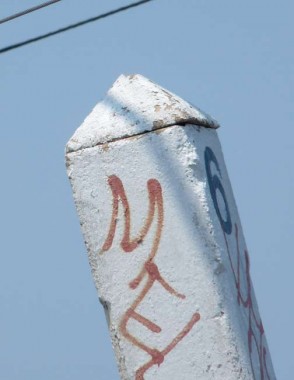
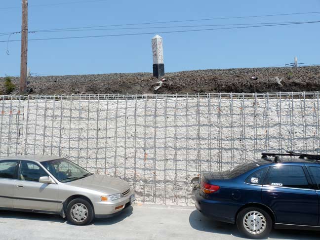
In the colonial era, mile markers were often placed along the main road to inform the traveler of how many miles there were to go to the nearest big town, or how far away you were from it. In NYC, the now-defunct Post Road in Manhattan, Kingsbridge Road in upper Manhattan (now a part of Broadway), Kings Highway in the town of New Utrecht (now Bensonhurst, Brooklyn), Northern Boulevard in Jackson Heights, and Ocean Parkway, built in the 1850s, all had such mile markers. Ocean Parkway, in fact, had half-mile markers, only one of which, the 3rd mile marker, is still in place.
Railroads, too, have mile markers. I have been riding the Port Washington Branch of the Long Island Rail Road regularly since 1992 and have noticed the occasional mile marker along the route. Recently, though, I nailed down where most of them were, though most are in spots to inaccessible to photograph without getting killed by a train or risking arrest.

This one is the 6th mile marker and can be found facing 44th Avenue along the tracks, which are on a raised embankment, just west of 111th Street. Along the route, I have now identified the locations of the 4th through 12th mile markers, which are along the line from Woodside east to Douglaston.
Recently, by keen observation out the train window, I found mile markers 2 and 3.
I do not know if these markers measure distance from Penn Station or from the East River waterfront, though since the 4th mile marker is just east of Woodside, I imagine the latter.
If there are any LIRR historians who know a) when these markers were placed — the 4th and 5th mile markers have been replaced with new ones recently; and b) if other LIRR branches have them, let me know in Comments.
Readers have come through:
Distance is measured from the LIC station in Hunters Point
Photos of mile markers elsewhere in the LIRR
12/14/12


18 comments
Kevin,
Mile marker 29 can be seen in a video I took back on May 23rd, 2009. The marker is located in Syosset, just west of the train station and is possible to see from the street (Railroad Avenue, just off of Jackson Avenue).
Here is the video
http://www.youtube.com/watch?v=UPxo7IW1lsk
There is also a mile marker 1 which is located next to the Hunterspoint Avenue Station in LIC. That one can be seen in my video from April 2nd, 2009. You can see the marker in the first couple of seconds, and is visible from the platform.
Here is the video
http://www.youtube.com/watch?v=JmUjgQDSbws
Hope you like them.
from what I know and feel free to correct me, the original line of the LIRR was laid out from LI City and thats why milepost #1 is there in LIC.
Has anyone spotted mile markers 2 and 3?
Mileposts are still very important to railroads, as they use them as points of reference (e.g. “there is work being done between MP 4.5 and MP 6.0”).
Here are pictures of other mileposts on LIRR:
http://www.trainsarefun.com/lirr/mileposts/mileposts.htm
and a discussion of where mileage starts:
http://www.railroad.net/forums/viewtopic.php?f=63&t=81166
I have no first hand knowledge of the LIRR’s practices but here in Australia all railways have the distances marked out with kilometre posts. Each system (and sometimes branch) has a defined starting point eg the sydney end of platform 1 at central, The distances are also used to identify fixed objects (signals, bridges, buildings, overhead gantries). Near me the marking 1140 means that the object is 11.4 from the start.
I suspect that most if not all railways use a system like this.
Milemarkers are not always a mile apart. Numerous railroads have had line relocations, which can shorten a route significantly.Or, in the case of an easier grade through the moutains, a line can be lengthened.
Since the labor agreements defined a day’s work as so many miles traveled, the realigned route often would have compressed sections, with some mile markes a half or quarter mile apart, in order to retain the timetable distance between two terminals. a lengthened line would have mile markets a mile and a half or more apart. Lines and railroad companies have merged, bought, sold, abandoned and aquired lines, which were integrated into the new owner’s system, yet retained the former owner’s mile markers based on the timetable of the line, and the labor transfers which went along with the track.
During the 1960s, my family lived in a house — on East 18th Street in Brooklyn — which bordered the former right way of the New York, Brooklyn, and Manhattan Beach Railway. The grade level tracks and locomotives were long gone. But a lone, surviving milepost still stood at the back edge of our property (even though, back then, none of us knew the purpose of the strange archaeological artifact, or that passengers headed for the beach had once steamed past that very spot).
Wow, I wish it could have been saved
Note that this was the railroad’s original right-of way, before it was rerouted to an embankment on East 16th Street in 1907 or so, right alongside what would eventually become the BMT’s Brighton Line.
Not long ago, I passed my old house while visiting the neighborhood. The milepost (which was once visible from the sidewalk if you knew where to look) is now gone.
The surviving Boston Post Road mileposts from NYC are at the NY Historical Society. I think they have 3 or 4 of them. A number survive outside of NYC city limits. I went looking for what was supposed to be the sole surviving mile post outside of captivity in Harlem last year (there was an article in the NY Times about it). Unfortunately, it was relocated to a City garden plot and then disappeared. Real shame.
there are numerous concrete mile posts on the LIRR Ronkonkoma Branch between the now defunct Republic Station (Route 110) and Deer Park (Route 231) in Suffolk County.
I have, in my back yard, what I assume to be the original granite “NY36” from between Chappaqua and Mt. Kisco. I cannot find ANY info or images from its past. I think these were originally 10′ long, this broke but it’s about 3′ tall . It has the ny36 on both sides etched in the stone and it weighs probably 300 lbs. very cool
I used to work at the Katonah Natural Market when I was home from college and a NY42 mile marker stands behind the store along the Metro North Hudson Line tracks. In fact I believe most of them exist on that line, so perhaps they’re still maintained? It was an eye-opener to realize that NYC was only 42 miles away even though traffic would extend it to a solid hour minimum!
*This is in the town of Katonah of course, in Westchester County
I know a nurse-reflexologist named Janis in Katonah.
mbt mens shoes
There is a mile marker “NY 7” for NY Central RR still in place at street level on Park Avenue between St. Paul’s Place and E170th St in the Bronx on the east side of the ROW
will take a look