By SERGEY KADINSKY
Forgotten New York correspondent
At the southern tip of the ridge that is the Highbridge Heights neighborhood of the Bronx, there is an abandoned subway tunnel that runs for four blocks beneath West 162nd Street. Once a vital link connecting the Ninth Avenue line in Manhattan with the Jerome Avenue line in the Bronx, it was reduced to a three-station shuttle with two-car trains shuttling spectators to games at the Polo Grounds. The 1958 departure of the baseball Giants to San Francisco resulted in the shuttle’s abandonment in August of that year.
Since then, Highbridge residents have had to make a lengthy walk to the nearest subway station while the tunnel became a destination for urban explorers and vagrants. While Forgotten-NY has been to it back in December 1999, I revisited its two former stations and the street running atop the tunnel.

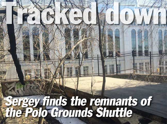
The Jerome-Anderson Avenue station used to straddle above Jerome Avenue. It was demolished nearly a decade after its abandonment. All that is left of it today is a windowless concrete building with an empty platform on its roof. Service below 155th Street-Polo Grounds ended in 1940, and while there was talk of connecting the Polo Grounds Shuttle with the Lenox Avenue subway line, it was the age of highways and this idea was rejected based on its cost.
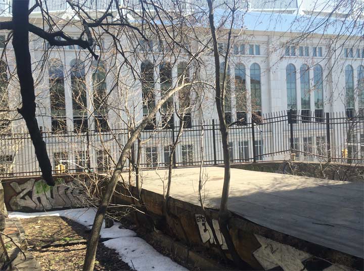
Looking east in 1999, Kevin Walsh faced Mullaly Park, which was built atop the buried course of Cromwell Creek. In 2017, the New Yankee Stadium faces the former station.

The graffiti on the walls of the former station is ambitious. When no one is chasing them, vandals have time to make elaborate tags that elevate graffiti from a simple tag to a fancy slab of interwoven colors. The portal to the tunnel is blocked by bricks.

1956

2017
On Jerome Avenue, the scenes from 1956 and 2017 hardly have anything in common. The station is gone and where the shuttle ran there is the new Yankee Stadium. A traffic triangle separating Jerome Avenue from the Macombs Dam Bridge approach was given the Greenstreets treatment in the 1990s.
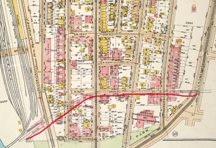
A 1921 Bromley atlas plate shows exactly where the tunnel runs below the street. On the west, the Putnam Branch shared the Putnam Bridge going into Manhattan with the elevated subway line.

A thin black line (signifying an elevated even though the tracks go through a tunnel) marks the course of the shuttle train in this 1945 Hagstrom map. White circles mark stations.

Plenty of photos have been taken of the H. W. Wilson lighthouse from across the Harlem River, but not so many from its Bronx side. Formerly the office of a book publisher, the facility is presently used for self-storage.
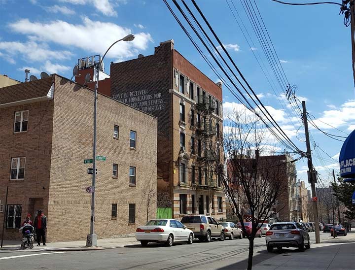
Across the street from the lighthouse is an apartment building with Corinthians 6:9 carefully inscribed on its side wall. From a distance it resembles a fading ad. “Neither fornicators nor idolaters nor adulterers nor abusers of themselves with mankind nor thieves nor drunkards nor revilers nor extortioners [sic] shall inherit the kingdom of God.”

At 164th Street and Ogden Avenue is the Taqwa Community Farm, a garden on city-owned land founded by Highbridge resident Abu Talib. It is one of nearly a dozen community gardens in the neighborhood established on vacant land where apartment buildings suffered wholesale abandonment in the 1970s. Taqwa is one of the larger gardens in Highbridge Heights in size and yield, growing 10,000 pounds of produce annually.
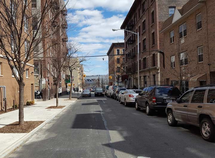
The shuttle tunnel runs under West 162nd Street between Ogden and Anderson Avenues.
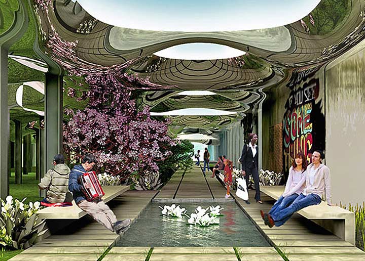
When looking at what could do done with the abandoned Polo Gounds Shuttle tunnel, it is clear that its revival as a subway line is unlikely with new Yankee Stadium in in the way and the bridge to Manhattan eliminated. Seeing the expansion of parkland in the most unlikely of spaces, the Lowline project of the Lower East Side comes to mind, as it seeks to transform unused trolley tracks at the Delancey-Essex Streets subway station into an underground park.
Why not do the same in Highbridge Heights? A pedestrianized Polo Grounds Shuttle Tunnel would connect Yankee Stadium with the Harlem River and along the way contain artworks and displays relating to its history. One can argue that this neighborhood’s counterpart to Manhattan’s High Line Park is the recently reopened High Bridge path. Transforming the Polo Grounds Shuttle tunnel into an underground park would give The Bronx its own Low Line, giving the borough a unique park experience.
Sergey Kadinsky is the author of Hidden Waters of New York City: A History and Guide to 101 Forgotten Lakes, Ponds, Creeks, and Streams in the Five Boroughs (2016, Countryman Press)
“Comment…as you see fit.”
4/11/17

25 comments
Great post, I love anything related to abandoned subway stations/tracks/platforms.
On that note, am I the only one who doesn’t want to see these abandoned sections of stations turned into parks? I’ve seen concept art for the Delancey/Essex lowline, and it looks pretty cool. But my favorite part about the Delancey/Essex St. station is looking at all the trolley tracks while waiting for the train. I think it’s a really great secret piece of history that’s hidden in plain sight.
Looks like someone took the time to clear the trash out of the trackways. When Joe Brennan first profiled this station back around 2001, the trackways were so filled with garbage, they were almost level with the platform.
Why do you call it Highbridge Heights? The area is historically known as simply Highbridge.
On the west, the Putnam Branch shared the Putnam Bridge going into Manhattan with the elevated subway line.
I don’t think the bridge was ever shared by both railroad and subway (or rather el) trains. Originally, it was for the railroad. Then, Putnam trains were cut back to Sedgwick Ave. and el/shuttle trains used the bridge.
Absolutely correct! In 1918, 6th/9th Ave El trains took over the bridge. The NYCRR Putnam Division had originally built the bridge to allow its trains to reach the 155th Street 6th/9th Ave El terminus. It was cut back to its own new terminus on the Bronx side immediately adjacent to the new Sedgwick Ave Station now used only by the the El trains. Not at any time were there any shared services across the bridge.
Prior to 1918, the Putnam Division trains ran over the Putnam bridge to the 155th st station. In 1918, the Putnam trains ended at the Sedgwick Ave station.
very interesting, thank you!
Good luck with a conversion to a walkway. When I was on a tour there, the tunnel part was so full of abandoned cars and junk, it was hard to walk–and that was years ago. It would take tremendous community will, support and money to convert this.
I believe the junkers were removed when the tunnel ends were sealed.
Charles 53
In 1940 when the 9th Ave was closed below 155th Street, there were plans to extend the Lenox Ave IRT line (today’s “3” train) over the bridge & through the tunnel to connect with the Jerome Avenue line, creating a Jerome/7th Ave service instead of just creating a shuttle.
From what I understand (please! correct me if I’m wrong — thanks!) apart from the obvious issue, $$$$, this didn’t happen because the tunnel had been built too narrow to accommodate subway-type 3rd rails, which were placed further away from the subway car floors than El-type third rails. It would have meant widening the tunnel, at least at the bottom, which they didn’t want (or couldn’t afford) to do.
Also, it would’ve meant keeping the 9th Ave El structure intact from around 143rd to 155th Street, in what was then a VERY anti-El era.
I understand the tunnel was also equipped with several extra exits because strictly legally, as of 1916, wooden El cars were considered a fire risk in tunnels….. and were not supposed to be there at all.
That neighborhood, sadly very badly decayed in the 1970s & 80s, is now rapidly improving. The Bronx’s first and most extravagant (in my humble opinion) art deco apartment bldg stands at 1005 Jerome Ave, just north of the tunnel…….so maybe the concept of some kind of tunnel park MIGHT work today (?).
A three block tunnel in the South Bronx. Yeah. that’ll work.
The tunnel might be an interesting site for a subway/trolley museum, except only IRT width cars, having had their third rail shoes shaved back, would be able to fit in it. It seems a shame to see the tunnel sitting there, unused, since 1958. Interestingly, the tunnel saw only 22 years of through (“non shuttle”) Ninth Ave El service: 1918-1940.
Those who moved into the adjacent Art Deco apartment buildings in the 1930s (such as the fantastic Park Plaza at 1005 Jerome Ave) must’ve been just delighted to see their direct, through access to Manhattan discontinued in 1940. I believe there were several protests at the time, but of course to no avail. The transit bosses had no intention of keeping the Ninth Ave El alive after 1940.
The ideal solution would’ve been to use the tunnel to connect the Lenox Ave subway line with the Jerome Ave line, but that would’ve involved retaining and, importantly, >>reinforcing<< the flimsy, rickety Ninth Ave El structure from148h Street to 155th Street for heavyweight steel subway cars. Which local residents apparently didn't want.
Also somehow widening the too-narrow tunnel to fit standard IRT subway cars' third rail shoes. At the time, the city didn't want to spend one more penny on the Els. They just wanted to be rid of them.
At first, in 1940, when the shuttle started running, from photos I've seen it had plenty of passengers …….. but these soon dwindled away. Like today, passengers really want a one-seat ride. So now the Highbridge neighborhood, which is rejuvenating, has no rapid transit service at all. A pity.
I personally remember them knocking down the Anderson/Jerome station and the section of elevated tracks connecting to the Jerome Avenue line in 1963. I believe (PLEASE correct me if I'm wrong) the 155th Street Ninth Ave el station and the Putnam Bridge over the Harlem River were removed in 1960. That would have been the very last of the original Manhattan Railway el stations left standing, five years after the Manhattan portion of the Third Ave El had been demolished.
Can someone please describe to me between the streets of Jerome Avenue and Major Deegan route 87; what this line elevated at all? Or did it go directly into the ground starting at Anderson Avenue / Woody crest /Ogden/ and not returning to above ground until where the Major Deegan route 87 is?
The Polo Grounds shuttle was elevated from its flying junction with the Jerome Ave (no. 4) line running above River Avenue at the point. It ran on an elevated structure through what was until 2006 a park, and is now Yankee Stadium. The elevated section never ran directly above 162nd Street. The stub turnout for the line is still there, having been shaved back a little bit when Yankee Stadium was built.
That elevated structure was demolished in 1963, along with the Anderson/Jerome Ave’s station one long block west. At that point that the line entered the tunnel under162nd Street, passing BELOW Woodycrrest and Ogden Avenues.
The Jerome Ave fare-control entrance to that station was at street level (demolished). The Anderson Ave fare-control entrance was in a building on Anderson Ave that still exists (albeit greatly modified since 1958 when the shuttle closed).
The line emerged from the tunnel at Sedgwick Avenue, three blocks west. That station, like Anderson/Jerome Ave’s, was partly in the tunnel, but the only entrance was on Sedgwick Ave. From there the line crossed the ex-NYCRR Putnam Bridge over the Harlem River to the ex-Ninth Avenue El station at 155th Street/8th Ave.
The tunnel is still intact. There are remnants of both stations at either end of the tunnel.
The Putnam Bridge was removed in 1960 (not a trace remains) and I believe (please, don’t quote me on this) the 155th Street Ninth Avenue El station was demolished very soon after shuttle operations ceased in August 1958.
There are loads of websites on this section, with terrific pics. Just look under “Polo Grounds Shuttle”. You’ll’ see it all!
I have enjoyed reading all your comments, I use to live in 164 th Anderson Ave from 1973-1980. So I am fascinated by all this information . Why do you know so much about the area? Hope to hear back. Thanks Dania
Thanks for all the informtion and comments. In the 1950’s, during my teen years, my parents were living in Hastings-on-Hudson. I adopted the Giants as my favorite NL team. I would take the NY Central to High Bridge, walk down to Sedgewick Station, and walk across the Putnam bridge to get to the Polo Grounds. It was a great place with great fans. Willy Mays was still playing and Bobby Thompson had returned to the team. I did not know until I read this article that the Putnam bridge had been demolished.
Never knew about the tunnel, My Mother lived on Ogden Ave back in the Mid 60’s
I lived at 1105 Jerome Avenue from ’56 to ’69. I clearly recall the abandoned Anderson/Jerome Station and how eerie it seemed to us kids in the early 60’s. Question for you all, did buses run to the Rockaways from the site of the station? I seem to remember taking one with my family, but not sure.
Dear Dania
Really sorry for having taken so long to get back to you. My apologies.
I’m originally from the Bronx. My grandparents lived not too far from the shuttle, and I remember seeing it running as a very small kid (I’m an old-timer of 66 now). My grandfather took me to see the Anderson/Jerome Avenue station being demolished in 1963. As I dimly recall, kids often used to play on the abandoned platform, which was not really that well sealed-off from the fare-control area on Jerome Avenue directly below.
The line was VERY lightly used. There was no token-seller at that station, only an “iron maiden”-type full-height turnstile. I remember a sign in the fare control area that read “No agent on duty.Token required”.
I remember seeing the abandoned Putnam Bridge, which was left in the swung-open position after the shuttle stopped running in 1958; the bridge was removed & scrapped in 1960. I believe it was the very last coal-fired, steam-powered drawbridge in NYC.
Ira, as far as I know (I could be wrong!) no bus ever ran from the Anderson/Jerome station to the Rockaways. My family used to rent bungalows in Far Rockaway during that period, and had there been a direct bus route from that station we probably would’ve used it.
More Polo Grounds Shuttle trivia (I’m a total geek on these subjects)! When the 6th/9th Avenue Els took over the NYCRR Putnam Bridge in 1918, the el line passed through the “new” Sedgwick Avenue station, leading directly into the rocky liff-face below Summit Avenue, where the Major Deegan Expwy is now. West 162nd Street did/does not extend west of Summit Ave all the way to the Harlem River. So the tunnel actually curved under existing houses, rather than under streets, for about two blocks — before finally curving under W. 162nd Street for its short underground run to the Anderson/Jerome station — and daylight.
The present Jerome Avenue el, three tracks, has girders for two additional tracks descending from the station just north of the new Yankee Stadium, which turn toward the new Yankee Stadium, then stop. Were these girders support tracks going to the Polo Grounds shuttle described above?
Yes indeed, those girders carried the 9th Ave El (later the Polo Grounds Shuttle) tracks. The Shuttle closed in August 1958 and
the elevated section from River Ave to Jerome Ave (including the Anderson/Jerome Station) was removed in 1963. The turnout
had extended for a short length, but it was cut back when the new Yankee Stadium was built.
I lived on West 162d St. 1978-1989.Had no knowledge of this fascinating era of the 9th Av El tunnel beneath our street.
My husband & I often wondered about the curved tracks protruding out from under the No4 line @ River Av & 164 street.
Now the new Yankee stadium sits @ this section of tracks.
FYI the Bible verse 1 Corinthians 6:9 was in-scripted on building for the opening scene of the movie
New Jack City & has been particularly covered by the construction of the homes built after the removal of bed rock which was in place @ West 162d & Summit Av
GREAT STUFF. THANKS. virtually a shuttle from Giants games to Yankees games……..if ever there was a need.
As a youngster in the Bronx, I was fascinated when taking the southbound 4 train between 167th and 161st stations. I remember seeing tracks going west from the River ave tracks over to Jerome Ave on 162nd street. If I recall correctly the tracks did not go directly above 162nd street, but slightly north of the actual street. I was too young to explore the abandoned Jerome/Anderson ave station, but I always wanted to visit the abandoned platform and tunnels going into and under Anderson Ave. Were passengers able to go down into that station from Anderson ave, how did they enter, buy tokens and get to the train platform?