STATIONS OF THE N.Y.W.B (Dyre Avenue Line)
Between East 180th Street and Dyre Avenue near the Westchester county line, the IRT #5 runs along an abandoned railroad, the New York, Westchester & Boston, which originally ran from East 133rd Street in Port Morris, South Bronx north to Port Chester.
While the width of the right of way, encompassing two extra tracks that are no longer there, provides a clue to its former railroad lineage, the most telling clue is the presence of several station houses along the route…a rarity for the NYC subway system.
We’ll take a look at three of these stations, starting with the most northern.
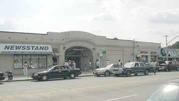
GUN HILL ROAD
East Gun Hill Road, about 3 blocks west of Eastchester Road
Today, the Gun Hill Road station carries few reminders that it once was a suburban railroad station. It’s home to modern storefronts along a bustling thoroughfare that was once an Indian trail and named for a cannon fired by patriots from a hill west of the Bronx River during the Revolution.


South of Gun Hill Road, the Dyre Avenue line travels over an elevated viaduct, but soon descends under street level. A malled thoroughfare, the Esplanade, one of a handful of singular-named NYC streets, is directly over the line.
Few know that the street’s actual name is the Westchester Esplanade. It received the name when this part of the Bronx was still in Westchester County (similar to the much longer Westchester Avenue).
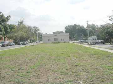
Walking south, the Pelham Parkway station is soon in view.
PELHAM PARKWAY
The Esplanade between Pelham Parkway and Astor Avenue
Once a express station. The Pelham Parkway station has a center platform entirely underground.
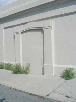
Long-ago sealed off side door.
Other than the omnipresent weed-studded Bronx concrete, the Pelham Parkway station does boast a bicycle rack, like many railroad stations in greener parts of the area.
South of Pelham Parkway, the Dyre Avenue line remains underground until encountering a very steep hill at Paulding Avenue, where it emerges to meet…
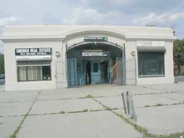
MORRIS PARK


The Esplanade at Paulding Avenue. Accessible by staircase from Woodmansten Place.
The Morris Park station retains some of the Spanish-style architecture it boasted when it first opened in the early 1910s.
Faint but still visible are some of the caduceus symbols that once were featured at most N.Y. W & B. stations.
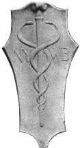
The Roman messenger god Mercury was deemed an appropriate symbol of the N.Y. W. & B., a high-speed rapid transit line.
Other caduceuses (is that the plural?) can be found on a trestle south of the Morris Park station, as well as the station house at East 180th Street.
– nycsubway.org’s Dyre Avenue line page, which emphasizes its subway operations
10/13/01