You’re not supposed to call it 6th Avenue, you know.
6th Avenue has a rather involved history. It has been extended both northward and southward and has been renamed twice!
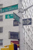
In 1945, Mayor Fiorello LaGuardia renamed Sixth Avenue along its entire length south of Central Park “Avenue of the Americas.” Some histories indicate it was done in honor of the new Organization of American States, but the OAS didn’t have a charter until 1948.
North of the park, Sixth Avenue was also laid out, but it wasn’t known as 6th for long. In 1887, it was renamed for wealthy art and book collector James Lenox, whose holdings in part established the New York Public Library. 100 years later, Lenox Avenue was subtitled Malcolm X Boulevard in honor of the civil rights activist slain in 1965.
After several generations of street signs tried, in vain, to imprint the Avenue of the Americas moniker on New Yorkers, in the 1980s the Department of Transportation gave in and installed “6th Avenue” signs along the street.
In the late 1950s, when modern octagonal-shaped aluminum lampposts began to appear on 6th Avenue, Avenue of the Americas started to truly live up to its name…as dozens of distinctive medallions bearing the coats of arms, or shields, of dozens of nations in North, South and Central America made their appearance on the new poles. Various rebuildings and reconstructions of ‘the A of A’ have whittled away at the medallions, which in some cases show former friends whose relationship with the USA has, shall we say, changed since 1945. On this page we’ll show you the remaining Avenue of the Americas medallions and just a little about the countries whose coats of arms they depict.
*Some photos on this page are fuzzy at best, since I snapped them in 2003 when I began this page. I have acquired a better camera and software since, and I will try to update the images when possible
2005: this post has been replaced by a retro-24M Corvington, and the Argentina sign is gone.
Argentina
Independence: 1816
Capital: Buenos Aires
Few countries in the western hemisphere have suffered as much chaos as has Argentina in recent years; its economy has been on the verge of collapse and at one point, it had five presidents in two weeks. Yet Argentina remains a top tourist draw for its natural wonders as well as Buenos Aires, considered by many to be one of the most cosmopolitan and civilized cities in the world. It resembles Paris with its wide boulevards and tree-lined streets, and its theatres, art galleries and museums are the equal of any in the USA or Europe.
Surprisingly, close to 50% of Argentina’s population can claim some Italian ancestry…the first Italian to visit was Sebastian Cabot, an explorer sailing under the Spanish flag in 1526. He obtained quantities of silver from the natives: Argentina’s name is derived from the Latin word for silver.
The country’s most colorful and popular political figure was Juan Péron, who was president from 1946 to 1955 and again in 1973-74: his government promoted a “third way” between capitalism and communism. His wife during his first term, Evita, was a controversial figure of enormous influence in her own right.
The Falkland Islands, off Argentina’s southeast coast, were the site of a brief yet vicious war in 1982 when Argentina, under the control of a military dictatorship at the time, occupied the islands, and Britain retook them.
The country’s rather odd coat of arms shows two hands clasping in front of a stick, at the top of which is the red Phrygian, or Liberty cap. Blue and white are the national Argentinian colors; the whole scene is overseen by the Sun of May, a representation of the Inca sun god Inti; the sun motif is repeated in the flag of Uruguay (see below). Its flag also features the two colors and the Sun of May.
Barbados
Independence: 1966
Capital: Bridgetown
![]() map of Barbados
map of Barbados
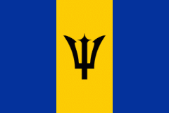
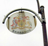
The tiny island of Barbados is the easternmost of the Caribbean islands, and is 166 square miles in area, making it smaller than many US cities. Sugar production and tourism are its main sources of income. Barbados was controlled by Britain from 1627 until it gained its independence in the mid-1960s.
The Barbadian coat of arms, depicted on its 6th Avenue medallion, carries its national flower (Pride of Barbados) in each corner of its golden shield, as well as the bearded fig tree (the tree from which Barbados derives its name). Though the English were the first to settle the island, it was actually found by the Portuguese, who, upon seeing the fig tree named the island ‘Los Barbados’, meaning ‘The Bearded Ones’. Later the English dropped the ‘Los’, calling the island simply Barbados. Also shown are fanciful representations of a dolphin (the fish, not the mammal) and pelican.
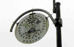
Belize
Independence: 1981
Capital: Belmopan
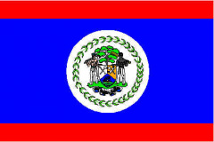
Belize, on the Yucatan Peninsula between Mexico and Guatemala, was an English colony and was formerly known as British Honduras. Its economy relies on agriculture, especially citrus, banana and sugar production, and there is also a sizable tourist industry. The Mayan civilization reached the height of its power in and around what would become Belize from approximately 250 to 900 AD.
The shield in the Belizan coat of arms, shown on the medallion, represents a ship in full sail on waves of the sea. The two upper sections show tools of the timber industry in Belize: a paddle and a squaring axe in the right section and a saw and a beating axe in the left section.
Supporting the shield are two woodcutters, the one on the right holding a beating axe over his shoulder in his right hand, and the one on the left holding a paddle over his shoulder in his left hand. Above the shield rises a mahogany tree. Below the sheild is the motto scroll. A wreath of leaves encircles the coat of arms.
Bolivia
Independence: 1825
Capital: La Paz
Bolivia is the highest country in South America, with most of it well above sea level; it can boast the world’s highest capital city as well as the highest navigable lake, Titicaca. Most Bolivians speak Spanish but many speakQuechua, the ancient language of the Incan civilization.
Agriculture, smelting, petroleum, food and beverages, tobacco, handicrafts, clothing, tin mining and natural gas are Bolivia’s legitimate means of trade; cocaine is a major illegitimate export.
Bolivia is named for the national hero of many South American countries, Simon Bolívar.
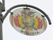
Bolivia’s coat of arms has an oval shape, inside which there appears the hill of the city of Potosí lighted by a bright sun, having in front to the right, the tree of bread and a sheaf of wheat with a llama on the left. The Andean Condor crowns the superior part of the ellipse that is also flanked on both sides by trimming of three flags, two guns and a cannon on each side. The word ” BOLIVIA” figures on the top part of the ellipse and on the bottom there are ten stars that represent the nine departments of the country, the tenth representing the coastline occupied by Chile since its 1879 takeover of the territory. Laurel and olive surround the condor to represent victory and peace.
Brazil
Independence: 1822
Capital: Brasília
Brazil is the largest country in South America and 5th largest in the world; it is so large that all countries in South America border it, with the exceptions of Chile and Ecuador.
Portuguese is the national language of Brazil. In 1494, the Treaty of Tordesillas was established, delineating the boundary between Spanish and Portuguese colonies in the New World with Spanish colonies to the west and Portuguese colonies to the east. Brazil’s breakaway from European rule came later than other South American countries; the Portuguese royal court fled to Brazil in the early 1800s to escape Napoleon.
Brazil contains the world’s longest river, theAmazon, and some of the world’s largest rainforests that feature flora and fauna exclusive to the region. The forests and the wildlife are under constant danger from extensive clearcutting and poaching.
Rio de Janeiro is one of the world’s most fabled cities. Of course, Carnaval, preceding Ash Wednesday in midsummer, is five days of drinking, dancing and partying outstripping anything the USA can muster including Mardi Gras.
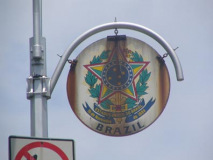
Brazil’s coat of arms, depicted on its 6th Avenue medallion, is a blue circle with a white depiction of the Southern Cross constellation on it, surrounded by 20 white stars on blue. Golden rays spread from the circle; upon these are tobacco and laurel branches surrounding the circle, and upon the branches appear the five points of a star, each half green half yellow. An upright sword lies behind the star, only the handle of which is visible. Underneath all there is a ribbon with two bends saying “Estados Unidos do Brasil 15 de Novembro de 1889″…since 1971, the country’s official name has been República Federativa do Brasil (Federal Republic of Brazil).
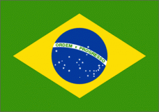
Brazil’s flag is a deep green banner with a yellow diamond enclosing a night-blue, star-studded Southern Hemisphere sky.
Canada
Independence: 1867
Capital: Ottawa
The name “Canada” most likely arose from the Iroquois word kanata, meaning “a group of huts.” The French originally called it New France.
Though Canada is the second largest country in the world it borders on only one other…the USA…and most of its population resides within 100 miles of the world’s longest undefended border. Canada attained its present size in 1949 when Newfoundland narrowly voted to become a province, rather than become independent. In the colonial era, France and Britain vied for control over the vast territory, and eventually Britain won out, after the bitter Seven Years’ War, in 1763. A substantial French population remained, especially inQuébec, ever since, and periodically agitates for independence.
Canada has enjoyed a generally friendly relationship (with a touch of wariness) with the USA, but it wasn’t always so. The USA invaded British-controlled Canada during the War of 1812, but was repelled.
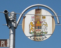
Canada has one of the ‘busiest’ coats of arms in the Americas.
Cuba
Independence: 1902
Capital: Havana
Cuba is the most westerly of the West Indies islands and is about 90 miles south of Florida. The island was ‘discovered’ by Columbus, sailing for the Spanish flag, in 1492. He found a tribe of Indians called the Ciboney; by 1600, the tribe was virtually extinct.
Beginning in the mid-1800s, Cubans engaged in two wars of independence against Spain. After the Spanish-American War the USA installed a governor but relinquished power to an elected Cuban government in 1902. In 1933, Fulgencio Batista took power in a coup and held it until 1959, when a guerilla campaign led by a young lawyer named Fidel Castrooverthrew him. The Soviet Union and the USA went ‘eyeball to eyeball’ over the presence of long range nuclear missiles there in 1962. In 2003, the island was the center of a tug of war between the Florida relatives and the father of young Elián González, who had arrived in Florida on a raft. At length, Elián was forcibly removed by the US State Department from his Florida relatives and returned home to his father.
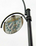
Cuba’s national coat of arms is shaped like a pointed shield and divided into three sections: in its horizontal upper part, there is a golden key between two mountains, and a sun rising over the sea symbolizing the position of Cuba between the two Americas, amidst the emergence of a new state. The blue and white stripes down the left hand side represent Cuba’s colonial period; down the right hand side, a Cuban country scene is dominated by a palm tree, meant to represent the character of the Cuban people.
Dominica
Independence: 1978
Capital: Roseau
Not to be confused with the Dominican Republic,which occupies the eastern 2/3 of the island of Hispaniola, Dominica is an island about halfway between Puerto Rico and Trinidad and Tobago. The last of the Caribbean islands to be colonized by Europeans, it passed from France to Great Britain in 1763, which made it a colony in 1803. After suffering under corrupt dictator Patrick John and devaststed by Hurricane David in its first 2 years of independence, Dominica stabilized when Mary Eugenia Charles was elected as the first female head of state in Caribbean history; she remained in office for 15 years.
Dominica retains a large amount of French and Creole culture from its colonial days and Carib culture from even earlier. One of the Caribbean’s most famed authors, Jean Rhys, was born in Roseau in 1890.
HERALDRY LINGO
Heraldry, the study of family or national coats of arms, has its very own impenetrable lingo, nearly incomprehensible to the layman. Here’s a technical description of Dominica’s coat of arms:
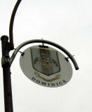
Quarterly Or and Azure a cross filled counterchanged in the first quarter on a Rocky Mount Sable a Coconut Tree fructed proper in the second a Dominica Crapaud also proper in the third on Water Barry wavy a base a Carib canoe with sail set all likewise proper in the forth quarter on a Rocky Mount also sable a Banana Tree fructed also proper and for the crest. On a Wreath Argent and Azure a Rocky Mount Sable thereon a Lion Passant guardant Or and for the Supporters. On either side of Sisserou Parrot (Amazona imperialis) proper beaked and membered or together with the motto Apres Bondie C’est La Ter.
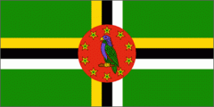
Simply put … the shield is gold and blue with four symbols: a coconut tree in the upper left, a frog in the upper right, a canoe with sail set in the lower left and a banana tree in the lower right, with two Sisserou parrots on either side and a walking lion on top. The banner bears the French phrase, “Apres Bondie C’est la Ter” (After God it is the land). Its flag also features a parrot.
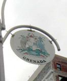
Grenada
Independence: 1974
Capital: St. George’s
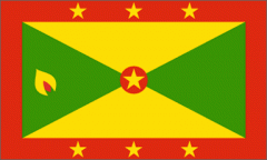
Most famous for its invasion by US forces in 1983 after a Marxist military overthrow of elected Grenadan leader Maurice Bishop, Grenada had been under British control since 1762, when the Brits captured the island from the French until granted independence in 1974. It is the southernmost of the Windward Islands in the West Indies northeast of Puerto Rico. Known as the “spice island”, a nutmeg is featured in Grenada’s flag; nutmeg is Grenada’s chief export.
“We are the most progressive country in the worldand I am one of the most dynamic leaders in the Caribbean…lots of people have tried to get rid of me, and they are lying in the cemetery.” –First Grenadan Prime Minister Eric Gaury in 1974
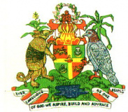
Grenada’s coat of arms shows the Santa Maria, the flagship of Columbus’ fleet, an English lion. The crescent, out of which comes a white lily, is a symbol for the Catholic population. The seven flowers on the helmet depict the seven parishes on the island. On either side of the shield is an armadillo and a Grenadan dove. The base shows the two mountains and the major lake (Grand Etang) on the island. The banner says, in English:
Ever conscious of God we aspire, build and advance as one people.
Haiti
Independence: 1804
Capital: Port-au-Prince
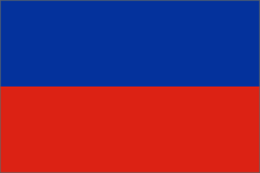
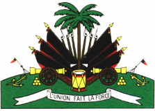
Occupying the western third of the island of Hispaniola, Haiti is a former French colony that became independent as a direct result of the slave revolt of 1791 led by freed slave Toussaint l’Ouverture and inspired by the American and French revolutions that preceded it. Rebel leader Jean-Jacques Dessalines tore the white out of the French tricolor flag of blue, white and red, declaring that he would rip the white man out of the country; Haiti’s flag remains simply red and blue today.
The Spanish and French had battled over Hispaniola since Columbus became its first European visitor in 1492. Europeans succeeded in exterminating the island’s nativeTaino people within 100 years of their arrival, but Taino words like barbecue, hammock and tobacco still survive.
More recently, the Duvalier family dominated Haiti from 1957 to the mid-90s, when Jean-Bertrand Aristide, a priest critical of the military regime that had taken over after Jean Duvalier had been exiled, came to power; he was overthrown by the military, but after Haitian refugees by the thousands started arriving in the US, former President Jimmy Carter negotiated Aristide’s return in 1995.
Honduras
Independence: 1838 (Honduras became independent from Spain in 1821 but remained in a federation with other Central American states until 1838)
Capital: Tegucigalpa
Columbus reached what is now Honduras in 1502 and gave it the Spanish word for ‘depths’, possibly alluding to its deep coastal waters. In subsequent decades theindigenous natives of the region were conquered and exploited by the Spanish, who were keenly interested in Honduras’ silver and gold deposits and banana trees. Honduras and neighboring El Salvador fought the brief but brutal Soccer War in 1969–when both countries also squared off in a World Cup qualifying match!
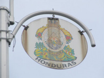
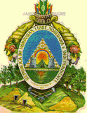
On its coat of arms, Honduras uses a pyramid rather similar to the one on the USA $1 bill, without the ‘all-seeing eye’ at the apex. On its base is a volcano between two castles; over them is a rainbow and behind the volcano a sun rises. The triangle is placed over land and around it is an oval containing in gold lettering: “REPUBLICA DE HONDURAS, LIBRE, SOBERANA E INDEPENDIENTE. 15 DE SEPTIEMBRE DE 1821” [Republic of Honduras, Free, Sovereign and Independent. 15th September 1821] On the top part of the oval there is a quiver full of arrows from which hang horns of plenty joined with a knot resting over a mountain range from which clearly stand three oak trees on the right hand side, three pine trees on the left, and mines, a bar, a drill, a wedge, and two hammers.
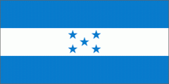
The five stars in Honduras’ flag stand for the original five nations in the Central American federation formed after independence from Spain was achieved in 1821, along with El Salvador, Costa Rica, Nicaragua, and Guatemala. The stars vary in their spacing from each other on certain flags.
Mexico
Independence: 1821
Capital: Mexico City
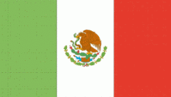
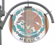
The Mexican coat of arms depicted on its OAS medallion depicts a golden eagle, with one talon standing on an imperial crown and a cactus, devouring a snake it holds in its other talon. The symbolism goes deep into Mexico’s Aztec roots: the eagle represents the sun god Huitzilopochtli, while the cactus represents the Aztecs’ greatest city, Tenochtitlan. According to legend, the Aztec people wandered Mexico in search of a sign that their god Huitzilopochtli had commanded them to find an eagle perched atop a cactus, devouring a snake. After two hundred years of wandering, they found the eagle and snake on a small island in the swampy Lake Texcoco, where Tenochtitlan was founded in 1325. There have been disputes, though, on whether a snake was part of the original legend. Some translations have the eagle holding the staff of the Aztec god of war, Atl-Tlachinolli, which could have been mistaken for a snake. In any case, Mexico’s coat of arms is among the most striking in the Americas.
The Mexican flag resembles the Italian flag, with the exception, of course, that the coat of arms is displayed on the center white stripe. Mexico’s great revolutionary president, Benito Juarez, set the meaning of the colors thusly: green for hope, white for purity and red for the blood of its heroes. While the name of the county is sometimes spelled Méjico in Spain, Mexicans prefer to keep its “x” as a matter of national identity.
There have been people living in Mexico for over 28,000 years, and great civilizations, the Aztec (Mexica), the Olmec, the Mayan; the Aztec city of Tenochtitlan, in the site where Mexico City now stands, was one of the largest cities in the world. In 1517 the Spanish under Velasquez and then Cortes arrived, and after a series of brutal wars there began a 300-year period of colonial rule. The invaders also brought diseases such as smallpox and typhus, previously unknown in Mexico, that wiped out 16-18 million of the 20 million indigenous people. Such was the end of the great Mexican civilizations.
A Catholic priest, Miguel Hidalgo y Costilla, is the father of modern Mexico; a series of peasant uprisings against Spain eventually won Mexico its independencein 1821. A northern province, Coahuila y Tejas, broke away in 1836 and declared independence; after Texas voted to consent to USA annexation in 1845, Mexico fought a two-year war with its northern neighbor that resulted in even larger swaths of territory joining the United States. France, under Maximilian I, occupied Mexico in the 1860s, but was overthrown by Benito Juarez and Gen. Ignacio Zaragoza, whose victory over the French at Puebla, May 5, 1862, remains a national holiday in Mexico, even though the French would not be completely driven out by Juarez until 1867.
Mexico was in conflict with internal struggles during the early years of the 20th Century, but the creation of a national political party, the PRI, stabilized it politically for decades; every president was a PRI party member for over 70 years. The party would not lose a Mexican presidential election until 2000, when a National Action Party candidate, Vicente Fox, took power.
Nicaragua
Independence: 1838 (Honduras became independent from Spain in 1821 but remained in a federation with other Central American states until 1838)
Capital: Managua
The Somoza family, which had ruled Nicaragua with an iron grip since 1934, gaining power in a coup in which opposing rebel leader Augusto Sandino was assassinated, lost power in 1979 to a popular revolution led by Sandinista rebels, named for the slain opposition leader. The Sandinistas were of a Marxist bent and soon were opposed by US President Ronald Reagan, who covertly directed the CIA to offer aid to the counter-revolutionaryContras. US support for the Contras continued secretly until the Irangate scandal showed that the CIA had illegally sold weapons to Iran at inflated prices, using the profits to fund the Contras. When Sandinista ruler Daniel Ortega allowed multiparty elections in 1990 his government was defeated.
Pittsburgh Pirates superstar Roberto Clemente died heroically in a plane crash while trying to deliver supplies to Managua, devastated by an earthquake on December 24, 1972.
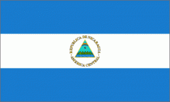
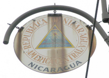
Nicaragua’s coat of arms depicts the country’s five volcanoes, a rainbow depicting peace, and the Phrygian cap representing liberty (seen previously in Argentina’s COA. Its flag also resembles Argentina’s although its blue is considerably darker.
El Salvador
Independence: 1838
Capital: San Salvador
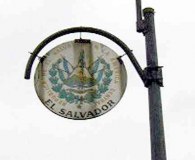
A large Indian civilzation had existed in El Salvador and the general Central American area for 4000 years before Spanish Captain Pedro de Alvarado began a war of conquest in 1524. After initial stiff and bloody resistance from the Indians, they were defeated in brutal fashion; Pedro’s cousin Diego de Alvarado established San Salvador in 1528. After El Salvador declared independence from Spain in 1821, it actually requested to become a U.S. state rather than succumb to a Mexican attempt to absorb the nascent Central American countries. But the US Congress rejected the request and the Mexican government fell. El Salvador joined its neighbors in the United Provinces of Central America, and ultimately declared sovereignty in 1838. El Salvador’s economy is largely based on its coffee exports.
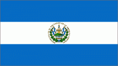
The Salvadoran flag consists of two blue stripes over a white one (in this it resembles the flag of Nicaragua and Honduras), in which is centered the Salvadoran coat of arms.
St. Kitts and Nevis
Independence: 1983
Capital: Basseterre
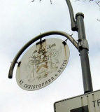
St. Kitts and Nevis are two Caribbean Leeward Islands that were former British colonies; they are still a part of the British Commonwealth. The two islands combined have a population of about 39,000. Its summer weeklong music festival, now in its 10th year (2005) has attracted worldwide attention.
The country’s former name, the Federation of St. Christopher and Nevis, is reflected on its OAS medallion. Its economy is based largely on sugar cultivation and tourism. Founding father and first US Treasurer Alexander Hamilton was born on Nevis in 1755 or 1757 (his birth date varies by account).
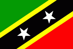
Its flag features a red and green triangle separated by two gold bands enclosing a black field on which two white stars are centered. Flag expert Eve Devereux (author of the Book of World Flags) maintains that the green is for fertility, red for the liberation struggle, black for the African heritage and yellow for sunshine. The white stars express hope and freedom.
St. Kitts and Nevis coat of arms
Surinam
Independence: 1975
Capital: Paramaribo
In a continent of large countries, Surinam is South America’s smallest. It is the former Dutch Guiana colony, and Dutch is still the official language though the native Surinaams is widely used as are other indigenous tongues. A third of the country (similar to neighboring Guyana) is descended from 18th Century Hindustani immigrants from the Indian Subcontinent. It is bordered by Guyana, Brazil, and South America’s last non-independent territory, French Guiana. Surinam has been a democracy since 1988; its economy is largely centered around the mining of bauxite, the mineral in which aluminum is found. There is also a large sugar industry.
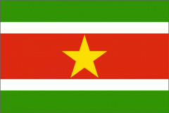
Surinam’s flag consists of two wide green stripes at the top and bottom surrounding two thinner white stripes that enclose a red field with a gold star at the center.
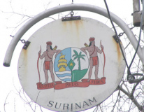
Its striking coat-of-arms features two Indians brandishing bows and arrow-filled quivers leaning on a shield on which is depicted a sailing ship, supposed to represent Surinam’s past (when slaves were brought there) and a palm tree, depicting its present. The five pointed star is symbolic of the 5 continents from which Surinam residents came from. The Latin motto, Justitia, Pietas, Fides, means Justice, Piety and Fidelity.
United States of America
Independence: 1776
Capital: Washington, DC
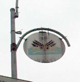
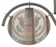
Yes, the USA has its very own OAS medallion (it probably had several, but right now the only one left is this very rusty one at 6th and Broome, just in front of the Moondance Diner.
The USA is the oldest independent country in North, Central and South America, and the second largest in area at 9.6 million km. Canada is the biggest at 9.9M km while Brazil is 8.6M km. It borders three oceans; the Bering Sea, the Caribbean Sea, and the Gulf of Mexico; and the five inland seas known as the Great Lakes. USA territory has been occupied for over 12,000 years, with approximately the first 11,500 by its many Native American populations. It was colonized by the Spanish, French, Dutch and even the Swedes, at the Fort Christina settlement in present-day Delaware. 13 colonies along the North American east coast rebelled against Britain largely because of the imposition of taxes without representation in British Parliament and gained independence after the Revolutionary War (1776-1783).
![]() USA history: Wikipedia
USA history: Wikipedia
![]() USA historic documents
USA historic documents
![]() Best of USA history websites
Best of USA history websites
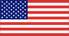
The US flag is a “living” flag; it changes over time, with stars in the blue field added to reflect additional states. The last change was in 1959 when Hawaii became a state. Presently the US flag alternates 5 rows of 6 stars with 4 rows of 5, but before Hawaii became a state, there were 7 rows of 7 stars; before Alaska in 1958, there were 48 states and the flag had 6 rows of 8. When the flag changes, a designer is assigned to produce the new configuration: Robert G. Heft designed the 50-star flag. From the beginning, there have been 13 alternating red and white stripes representing the 13 original colonies, with red always at the top and bottom. In heraldry the US flag is rendered: “A banner Gules, 6 bars Argent; the canton Azure charged with 50 mullets Argent.”
![]() Flag designs over the years in Wikipedia. Flag designers have had to get imaginative when there were numbers that don’t divide well, like say, 31 or 46 states.
Flag designs over the years in Wikipedia. Flag designers have had to get imaginative when there were numbers that don’t divide well, like say, 31 or 46 states.
The USA coat-of-arms is known as the Great Seal. The seal has an obverse and reverse, with the obverse on the OAS medallion. The national bird, the bald eagle, has wings outstretched and in its left talon clutches 13 arrows for war, and in the preferred right talon an olive branch for peace. In its midsection is a shield bearing red and white stripes and a blue field, but no stars. the 13 stars are instead located in a blue field surrounded by gold above the eagle’s head. In its beak the eagle holds a streamer reading the Latin phrase “E pluribus unum,” or “out of many, one.” The reverse shows a pyramid with the “all-seeing eye” representing Providence. It bears the Latin phrases “annuit coeptis” (“providence has favored our undertakings”) and “novus ordo seclorum” (“a new order of the ages”). The roman numeral for 1776, MDCCLXXVI, is inscribed on the base of the pyramid. Both sides of the Seal appear on the US one-dollar bill.
Uruguay
Independence: 1828
Capital: Montevideo
Uruguay has, perhaps, the most wonderful of all of South America’s countries’ names; in the native Guarani language, it means “river of painted birds.” The warlike Charrua Indians successfully ended off initial colonization of the area during the first great wave of European invasions in the 1600s, but the city of Montevideo was established as early as 1723. Though Uruguay was an Argentine colony by the 1820s, Brazil and Argentina contested over the valuable territory, with the Rio de la Plata containing important harbor waters, After Brazilian annexation it in 1821 and a revolt in 1825, the British created the independent state of Uruguay in 1828 as a buffer zone between their interests in Argentinia and Brazilian expansion from the north.
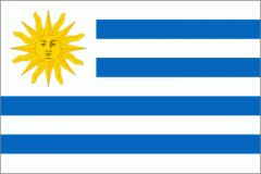
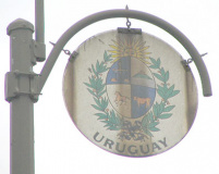
The Uruguayan flag consists of nine alternating stripes of white and blue, with white at the top and bottom, and a white field containing the golden Sun of May, which we have already seen on the Argentine flag. Its coat of arms features a quartered oval containing scales representing justice, a city on a hill (Montevideo) and a horse and ox for liberty and plenty. The symbols are contained in alternating blue and white cantons, or backgrounds. The Sun of May overlooks all.
Venezuela
Inependence: 1830, when it seceded from the Republic of Gran Colombia
Capital: Caracas
Venezuela‘s name means “little Venice”; in 1499, Amerigo Vespucci, sailing along the coast along the Gulf of Venezuela, noticed the native stilt villages built over the inlets, that reminded him of the canals of Venice. The territory became one of he first permanant Spanish settlements in the “New World” in 1522.
Venezuela can count Simon Bolivar as its most prominent son. The founder of modern South America was born in Caracas in 1783. Bolivar, with the aid of Generals José Antonio Páez and General Grand Marshall Antonio José de Sucre, won the Battle of Carabobo in 1821 and most importantly, José Prudencio Padilla won the naval Battle of Lake Maracaibo in 1823 to definitively break from Spain. Venezuela then joined with Ecuador and Colombia to form the Republic of Gran Colombia until Venezuela declared itself a sovereign republic in 1830 with Páez its first president.
The USA and much of the world have always taken a keen interest in Venezuela because of its oil reserves. Until recently US oil companies like Exxon, Shell and Gulf have enjoyed considerable political and economic influence there. Venezuela nationalized its oil industry in 1975 and joined the Organization of Oil Producing Countries. Venezuela’s government, and its relations with the United States, have undergone some volatility in recent years under President Hugo Chávez, who took office in 1998.
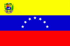
The Venezuelan flag features, from top to bottom, yellow, blue and red stripes: yellow: representing nobility and wealth; blue for loyalty and justice (also the ocean that separates Venezuela from Spain, the motherland); and red for honor and bravery, as well as the blood of all who fought for Venezuela’s liberation. The yellow stripe contains the country’s coat of arms while the blue stripe features seven white stars arranged in an upward-facing semicircle that stand for Caracas, Cumaná, Barcelona, Barinas, Margarita, and Mérida & Trujillo, the seven Venezuelan provinces that signed the independence act in July 1811 that began the break from Spain.
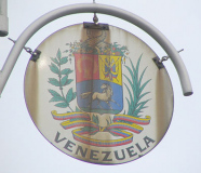
Venezuela’s coat of arms features a shield with three fields in red, yellow and white with 20 ears of wheat representing the unity of the 20 Venezuelan states (when the coat of arms was designed); two crossed swords and two flags entwined by a laurel wreath, as an emblem of victory; and an untamed white horse, a symbol of freedom. The shield is topped by two cornucopias and the bottom shows a ribbon with the colours of the flag uniting the laurel and olive branches bearing the inscription: “República de Venezuela; Independencia, 19 de abril de 1810; Federación, 20 de febrero de 1859.” (Venezuela achieved home rule on April 19, 1810 though not independence while February 20, 1859 remembers Venezuela’s Federal War. The bottom banner is emblazoned with “República de Venezuela.”
Of course there are several countries missing here: most of the Caribbean, Guatemala, Costa Rica, Panama, Colombia, Ecuador, Guyana, Paraguay and Chile. If anyone finds those medallions on 6th Avenue, let me know.
SOURCES:
I have depended on wikipedia.org, Flags of the World, and lonelyplanet.com (when lonelyplanet was featuring detailed country histories) as well as thePeople’s Almanac by David Wallechinsky and David Wallace (which, having been publiahed in 1975, is outdated for recent country histories.
Your webmaster earned solid C’s in history and social studies, so any corrections will be gladly accepted.
This page was photographed in April 2003 and December 2005; page completed December 18, 2005.



8 comments
It would be great if you could give the cross streets for each remaining medallion. Is there any movement ro restore them?
Ay, yi. That, I can’t do. Between Canal and West 4th, and between W 57th and Central Park.
Is there anywhere to find the cross street information?
We are looking for the Guatemala medallion specifically.
And thanks to Kevin as well as Mayor LaGuardia.
I have the Ecuador one. It’s a picture from a friend of mine and I’ll ask my friend’s permission to give it to you. But in return, if you can possibly tell me when it was installed. I’m just looking for an approximate date. Thanks
By combining the more durable-edged-but-soulful philosophy of Chicago house with the
melodies of obscure funk, state-of-the-art production methods and the sound of
analog synthesizers, they started to create the standards that may shape all house music.
Undeniably believe that which you stated. Your favorite reason seemed to be
on the internet the simplest thing to be aware of. I say to you, I definitely
get irked while people consider worries that they plainly
do not know about. You managed to hit the nail upon the top and defined
out the whole thing without having side-effects , people could take a signal.
Will probably be back to get more. Thanks
Would love to see the full list, I am sure there will be forgotten countries that built the country and still immigrate here.
What about Peru, Ecuador, there are countries missing.
Thank yoj!