It’s become something of a series.
A few years ago I set off under the Westchester Avenue El between Parkchester and Pelham Bay Park in the Bronx, and finished off my journey “under the 6” some time later. Then, Sergey wrote about Livonia Avenue and I walked the length of New Utrecht Avenue, both of which are mostly covered by elevated trains. I had previously done Fulton Street in Cypress Hills and Jamaica Avenue in Woodhaven. My very first ForgottenTour in June 1999 explored the underside of Brooklyn’s Broadway. Part of my Myrtle Avenue extravaganza was under the section that still had an elevated train.
I have yet to do the other “elled” section of Westchester Avenue under the #2 train, as well as White Plains Road that supports the #2 and #5. Had there been a Forgotten New York in the 1930s, there would have been pages on the 2nd, 3rd, 6th and 9th Avenue Els. As it is now, only a very small section of el still stands in Manhattan, but it runs over three separate streets — that will be the subject of a walk I did recently in Manhattan and the Bronx.
Why els? When you were a kid, I’m sure you used to upend rocks or logs in the park to see what scurried out when you did — ants, worms, etc. that are sources of endless fascination for kids. For me, now writing in my 50s, fascination has always come from seeing anomalies and leftovers from previous eras that somehow have survived under els where city agencies can’t see them such as signs, lamps and even unchanged stores and businesses. Thus, I walk in darkness, under the els…

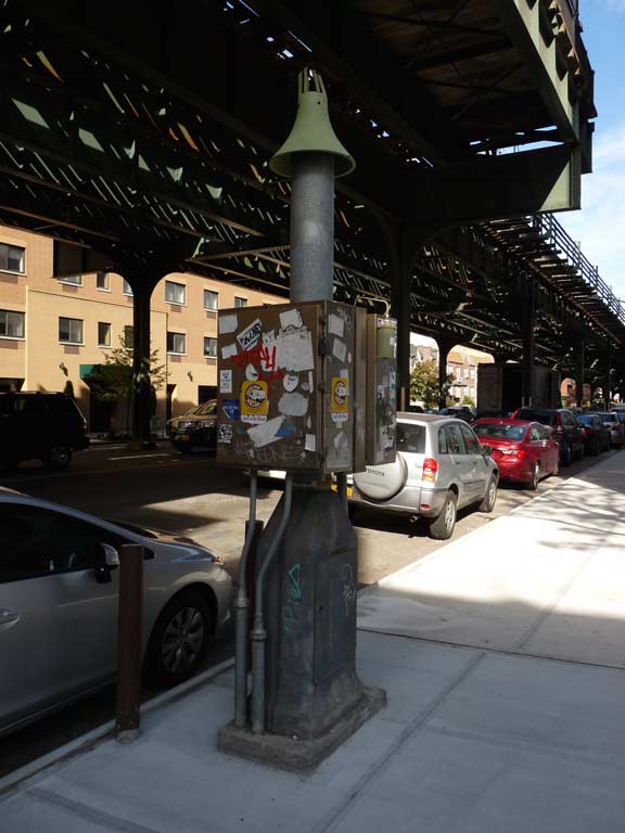
A Dugong-style vent (named for its finned aspect), which allows underground gases to escape safely into the atmosphere, has been installed on 31st Street north of Broadway.

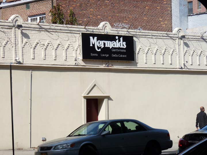
Mermaids usually perform in aquariums like Weeki Watchee, but they have been increasingly employed at strip joints and “gentlemen’s clubs” — their tails are prehensile and surprisingly strong and can expertly wrap around a stripper pole.
Mansion, 31st Avenue east of 31st Street. This must have been magnificent before it was shrouded under aluminum siding; some of its old grandeur shines through.
As it turns out this is the former home of “The Father of American Musical Education”, Ferdinand Quentin Dulcken (1837-1901) and is in danger of imminent demolition as of March 2017. Queens Crap has a then-and-now comparison; it was indeed grand in previous years.
Though the Greek Orthodox congregation of St. Demetrios has been in existence since 1927, its neo-Byzantine cathedral at 30th Drive and 31st Street was completed in 1975. The titular saint was a soldier and Christian martyr in the 4th century in the Greek province of Thessalonica, which was then occupied by the Roman Empire.
The Taiwan Union Christian Church was founded in 1970 and occupied the former Second Reformed Church of Astoria church building beginning in 1983. Information on the building is sketchy but I do know that the Second Reformed Church was founded in 1859. If this is its original church building it would be one of the oldest structures in Astoria. I like the way some of the old detailing has been retained, such as the narrow timbers at the entrance. There is no visible cornerstone. Any info? kevinjudewalsh@gmail.com
The present building goes back to 1867 according to the American Guild of Organists.
Brick dwelling at 30-33 31st Street– still has its original doorway. Check out the detailing!
Although it’s has a residing job and a new polygonal oriel window installed, this dwelling could be of the same vintage as the Second Reformed Church.
The framing appearance produced by the el pillar brackets comes into play again here. These are some old school apartment buildings going back to 1915 or so.
Grand Wine and Liquor, 31st Street south of 30th Avenue. The awning sign is practically new and nothing special. Why am I showing it? That’s no random act of naming and there’s a specific reason why “Grand” was selected as the name of the store.
30th Avenue, one of the major shopping drags in Astoria, is served by the 30th Avenue/Grand Avenue station. This can be a bit confusing, since Queens’ present-day Grand Avenue runs through Maspeth and Elmhurst, a good 5 miles away.
The reason for the station and liquor store name (as well as the Grand Court apartment house at 30th and Steinway Street) is that before most Queens streets received numbers, 30th Avenue was called Grand Avenue, and the Maspeth/Elmhurst Grand Avenue was called Grand Street; it’s an eastern extension of Williamsburg’s Grand Street. Flushing Avenue, which runs through parts of Brooklyn and Queens (but not Flushing), intersects a Grand Avenue in Clinton Hill and ends at another one in Maspeth!
This kind of thing fascinates me to no end….
Newtown Avenue intersects 31st Street at an angle, meaning it defies the street grid.
Like a number of streets and roads in NYC, Newtown Road and Newtown Avenue aren’t named for the neighborhoods where they are, but for the neighborhood they go to. And, like a number of NYC streets that run aslant the overall grid, they’re two of the older roads in the area. Both Netwown Avenue and Road comprise an Indian trail that became the main road to early Astoria settler William Hallett’s farm in the mid-17th Century, and to the treacherous Hell Gate, the East River crossing to Manhattan. Its eastern stretch that ended in the heart of Newtown, now Elmhurst, was called Hurlgate, or Hellgate, Ferry Road; later named for the town through which it passed, becoming Woodside Avenue.
Newtown Avenue and Road were once one road, but today Newtown Avenue runs from Astoria Square to 30th Avenue and 33rd Street, while Newtown Road picks up at 30th Avenue east of Steinway Street and then runs to the confluence of Northern Boulevard and Woodside Avenue.
Another pair of ancient homes on 31st north of 28th Avenue. These are set on slight slopes and so require staircases. The front lawns are unusual and likely predate the el (which was completed in 1920). Note original door.
Columbus Square (modern signage calls it Columbus Triangle) is where Astoria Boulevard, coming in from the west, becomes the Grand Central Parkway service road. West of here, Hoyt Avenue North and South is the service road. Sculpted by artist Angelo Racioppi, the statue depicting Christopher Columbus, the Italian voyager sailing for Spain, seeking an easier route to the Far East was dedicated on October 12, 1941.
The statue was actually completed before WWII broke out but was never erected because money could not be found by sponsoring Italian-American neighborhood associations for its base. It was unveiled here October 12, 1941, but spent the war years in the basement of Queens Borough Hall lest it be removed for use in the war effort. It was restored to its position in 1945.
The last two stations on the north end of the Astoria Line are unusual. When the Grand Central Parkway, the approach road to the Triboro (RFK) Bridge, was constructed in the 1930s, extended walkways were installed to allow passengers to get off on Astoria Boulevard; presumably, the old exits were on a section of 31st Street that is now on the overpass crossing the GCP.
The station has a center platform and, provided you’re in the right position, a picture postcard view of the Triboro is available.
I’m sure you’re familiar with NYC’s guy-wired standard issue intersection stoplights… they’ve been installed by the thousands since the mid-1950s. Rarely, though, this alternate design that resembles stoplight masts in other cities is used for extra-wide intersections.
The Neptune Diner on the NE corner of 31st and Hoyt Avenue North was voted “best burger” by NY Daily News readers during the 1990s. I have been in just once — it’s more of a “restaurant” experience than a diner experience — slightly more formal, though no dress code is required. Yelp.com reviews are middling.
While shooting The Hunger, a high-concept vampire flick, in 1982, David Bowie and Catherine Deneuve dropped in.
A bus tracker for the M60 bus, which connects Harlem with LaGuardia Airport via the Triboro, and the Q19, which runs chiefly on Astoria Boulevard, has been installed on Hoyt Avenue North west of 31st Street. Hope you brought a paper or some kind of reading device if you want to catch the Q19.
I profiled Bohemian Hall, 24th Avenue just west of 31st Street, for many years NYC’s only remaining outdoor beer garden, just recently in FNY. It’s been a favorite joint for years.
Old school apartment building, likely predating the el, on 31st between 23rd Road and 23rd Avenue. Plenty of extra expense must have been used for those elaborate treatments around the entrance and second floor window. I wonder if there’s a story behind those.
Another standalone residence of presumed great age on the west side of 31st near 23rd Avenue. The front lawn leaves room for…
… a painted ad for State Farm Insurance on the adjacent apartment building. There is no longer an insurance office on the ground floor. The insurance firm was founded in Illinois by retired farmer George J. Mecherle in 1922; in 1971, Barry Manilow composed its ubiquitous TV/radio jingle, “Like a Good Neighbor, State Farm Is There.”
One of the most dynamic (in my opinion) subway terminals in NYC us the Ditmars Boulevard station, as it is canopied by one of the massive concrete arches that supports the railroad tracks bringing train traffic to and from the Hell Gate Bridge. Surrounding streets are also covered by similar arches of various heights, and I photographed most of them for this FNY page.
Both the elevated and the Hell’s Gate Bridge were built in the mid-to-late 1910s, with the Hell’s Gate Bridge opening just a bit earlier than the el, 3/9/17 versus the el’s 7/19/17. The Pennyslvania RR and the BMT/IRT must have communicated during the construction process to assure adequate clearances.
On both sides of the arch, Ecuadorian immigrant graffiti artist Sandra Fabara, better known as Lady Pink, worked with local kids to produce two murals, one depicting Native Americans before the arrival of Europeans and the other loosely showing “Great American art and culture.” Lady Pink’s own works have appeared from time to time all over the city.
The Astoria El ends midway between 23rd Avenue and Ditmars Boulevard, which stands in for 22nd Avenue (coincidentally, in Brooklyn, 22nd Avenue is replaced by Bay Parkway). From time to time, there have been calls for an extension of the el north on 31st Street and then through the Con Edison power plant area to LaGuardia Airport, but these have always been negated by locals and their political representatives who fear too much noise and the shadows produced by elevated structures.
El construction has come a long way since then — think of the Airtrain elevated structure on the Van Wyck Expressway for a modern example. But opinions have held firm and such an el extension to LGA will likely never happen.
Ditmars Boulevard, named for Abram Ditmars, first mayor of Long Island City, NY elected in 1870, runs from the Hell Gate waterfront to Astoria Boulevard and 112th Street, paralleling Grand Central Parkway and LGA for the eastern half of its route. It has some history and secrets, as I showed on this FNY page.
I wasn’t done walking — 31st Street from Queensboro to Ditmars isn’t that long — and set off east on 23rd Avenue with my eventual destination being the IND station at Steinway Street (which, of course, wasn’t running locally on the weekend; I got the Q18 on 30th Avenue, arriving just in time to see the bus leaving before I could get there — which meant that the next scheduled bus would not appear and I would have to wait 45 minutes for the one after that. So much of my life is scripted, you’d think Vince McMahon of the WWE was pulling the strings someplace.
Tammany Hall was an organization associated with the Democratic Party that dominated NYC politics for about a century, from the 1830s through the 1930s. The name was a bowdlerization of the name of a (likely fictional) Indian chief. Another “creative” misspelling occurs here on a very old sign at the old HQ of the Taminent Democratic Club at 23rd Avenue and secreted under the Amtrak RR trestle at 32nd Street.
Here’s the Amtrak trestle in all of its faded magenta glory at 23rd Avenue and 33rd Street (it received a bright magenta paint job in the 1990s that immediately started to fade).
I could not resist getting several photos of the Hell Gate arches at 32nd and 34th Streets. In my opinion they should be named New York City Landmarks.
Coincidentally, I could not resist snapping these rusted, scrolled iron wall lamps that accompany most of the arches. They once lit the sidewalks under the arches, but if I can hazard a guess, haven’t worked since the 1960s or so.
The Queens branch of the Muslim American Society is located at the Dar-Al-Dawah Mosque in a former Christian church at 23rd Avenue between 33rd and 34th Streets.
The Greek Orthodox Church of St. Irene Chrysovalantou, 23rd Avenue between 36th and 37th Streets. The saint was a 9th Century miracle worker in the Byzantine Empire.
There are two remnants of the old Astoria Silk Works on 23rd Avenue between 38th and Steinway Streets. The Mattman brothers established the silk works factory here in 1888. Jacob Ruppert, beer brewer and NY Yankees owner, was president in the early 20th Century. The works had 36 looms and employed 150 people, making velvets, plushes and dyed pieces, making $8 a week, a decent figure in the 1890s. In the 1920s, ASW expanded to a mill near West Point, but a fire shut down that location in the 1950s.
A tall brick factory building, as well as a smokestack bearing the initials ASW survive. Coincidentally, or perhaps not, Astoria Sound Works is now on the site.
Completely disguised after decades after their initial purpose ceased, a pair of saloon/restaurants serving the Silk Works and nearby Steinway Piano Factory workers face each other on Steinway Street on the corner of 23rd Avenue: the Joseph Hoenlin and Otto Fuhlrott Hotel/Saloons.
Tiny Sound Street runs just one block, one-way south between 23rd Avenue and Astoria Boulevard. Nevertheless, it’s an important conduit, since it brings traffic to an overpass over the Grand Central Parkway. Together, with 23rd Road, it’s a remnant of a former ancient settlement, East Astoria.
East Astoria was a very small community located on Astoria’s eastern edge, about where Astoria Boulevard and Steinway Street — 43rd Street are now. It was developed earlier than the surrounding area, and when more streets were finally cut through, East Astoria’s small street grid survived. North-south streets were Planet Avenue and Sound Street, while east-west streets were Bremen Avenue, Frankfort Avenue (both of course, a sign of Astoria’s mostly German population during the 19th and early 20th Centuries) as well as Nassau and Flushing Avenues.
Over the decades, surrounding development swallowed up East Astoria, and its death knell as a separate community came when Robert Moses rammed through the Grand Central Parkway connection to the Triborough Bridge.
And yet…East Astoria hasn’t completely been killed. As you can tell from the present-day Hagstrom, two streets defy the grid to this day, 23rd Road and Sound Street.
Sound Street has never been completely conquered. Indeed… it’s important today, as it provides a means for traffic to cross the GCP.
Flushing Avenue became Astoria Boulevard, and Nassau Avenue was demolished for the GCP. Planet and Bremen Avenues have disappeared.
Eve today, there’s something … different about 23rd Road between Steinway and 42nd Streets. In spots, there is no sidewalk, and on some corners, the Department of Transportation installs no street signs. To an outsider, it seems like a ghost street, and in a way it is — a ghost remanant of a small town.
It was time to kick it in the head for the day and, before my interminable wait at the bus stop, I regarded one of Queens’ most gorgeous brick churches, St. Joseph’s R.C. Church, 30th Avenue between 43rd and 44th Streets. The church was organized in 1877 when there was a large amount of German Catholics in the region (the Steinways had set up their piano manufacturing plant in Astoria that decade), with the first wooden structure erected in 1880, and the current building with its massive campanile (bell tower) in 1906. Catholic churches seem to build the equivalents of small towns for their parishes, and the church is surrounded by a school rectory and convent.
11/13/16
