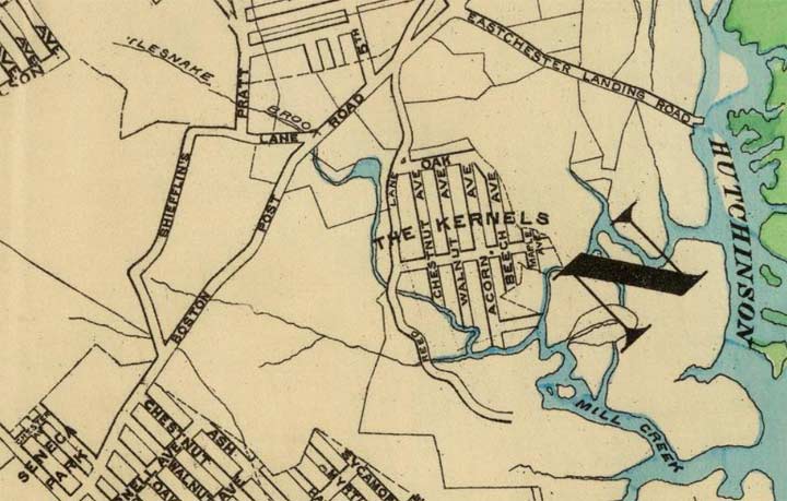
This section of a Hyde map of the northeast Bronx shows a small area called The Kernels. Its pedigree goes back to the colonial era when a Cornelius Jones, known as “The Colonel,” owned a tract on the west shore of the Hutchinson River. After a time his property was sold to developers, and a small grid of streets was laid out in the area by the Civil War area, the name corrupted to “The Kernels.” I’m unsure if these streets were ever laid out; however, other small developments like Bronxwood Park and South Vernon Park were indeed developed and still leave traces today.
This was in a swampy area frequented by rattlesnakes; Mill Creek, which issues from the Hutchinson River, later narrowed to a brook called rattlesnake Creek. Most of both waterways are now in the sewer system, but some of Rattlesnake Brook surfaces in Seton Hall Park.
The area remained unfrequented for decades, but streets were mapped through in the early 20th Century that were never built. While the Freedomland amusement park briefly held down this region from 1960-1964, permanent occupation would have to wait until 1968 when the first units of Co-Op City opened.
Does any trace of “The Kernels” remain today? Sort of. The small site was accessed on this map by Reed Lane. A portion of this road exists today as Reed’s Mill Lane, which remembers a tide mill on the Hutchinson River built in 1739 and in operation until the Civil War. Boston Post Road is today’s Boston Road, which gains the “Post” after entering Westchester County.
The exact site of the Kernels is now the west end of Co-Op City and the roadbed of the New England Thruway.
Check out the ForgottenBook, take a look at the gift shop, and as always, “comment…as you see fit.”
6/18/18


1 comment
Reed Mills Lane was built…the rest wasn’t.