
Some time ago I received a gift card for Greenlight Bookstore, an indie bookstore on Fulton Street in Fort Greene. I had forgotten about it for awhile even though it was in my wallet: but I finally visited the store and spent some of it. Unfortunately Forgotten New York the Book wasn’t on the shelf and neither was Forgotten Queens, but both have been in print for a number of years now, and more recent fare was displayed.
Since I was in the area and the sun was out (a rarity this May) I thought I’d explore a pair of streets I had ignored up till the present, Adelphi Street and Park Avenue (yes, Brooklyn has one and in fact every borough has one). Adelphi is five letters short of Philadelphia, which is derived from Greek terms phílos and adelphós, “love” and “brother.” Brooklyn’s Adelphi Street in turn had been named for London’s Adelphi Terrace, an early housing development in London, England that lasted from 1774 to 1938; the word also appears on Bay Ridge’s Adelphi Academy, which was founded on that very street.


Getting off the C train at Lafayette Avenue you are actually at Fulton Street and South Portland Avenue. Immediately, you see a beautiful brownstone building with terra cotta trim on the west side of South Portland, adjoining a plain modern whatsis, #81 Hanson Place. It’s hard to believe that this is all one building, but it is. In 2012, artist David Salle, who owned both properties, decided to combine them into a single unit that he put on sale at the time for over $10 million. I don’t know if he got that kind of money for it. The Portland Avenue side was originally a Masonic lodge that later became a public school. The two dates, 1881 and 1892, denote the date the lodge was founded and the date of construction. You can apparently own a lot of property making art.
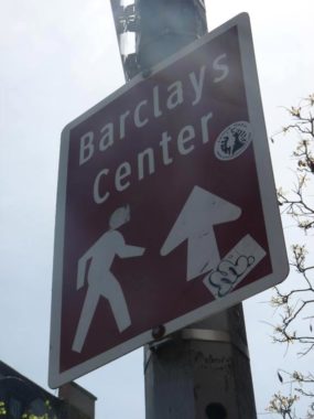
This Department of Transportation sign points the way to Barclays Center, the basketball, hockey and concert venue. It’s in brown, which is a legit color according to the US Department of Transportation Federal Highways Administration, which stipulates that brown backgrounds are used on signs for “guidance to sites of public recreation or cultural interest.”


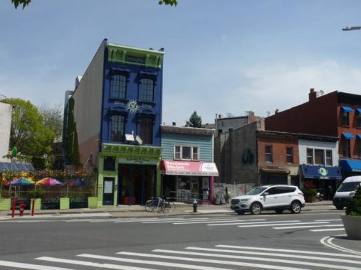
There’s a handsome trio of apartment houses on South Portland, stretching around the corner onto Fulton Street (the Greenlight Bookstore occupies the ground floor on the Fulton side). From the Beaux Arts era of 1890-1910, detailing and ornamentation weren’t spared, especially at the entrances that feature Ionic columns and blue and white mosaic tiling. This section of Fort Greene isn’t landmarked so I’m in the dark about building specifics.
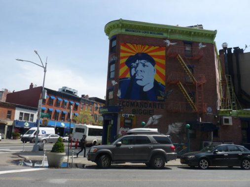
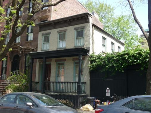
The owner of this building at South Portland and Fulton, Sean Meenan, operator of the Habana restaurant, has named it the Brooklyn Love Building. The colorful murals on the side of the building were created by the graffiti artist Cern. Christopher Wallace, the Notorious B.I.G. (1972-1997), was recognized by Billboard Magazine as one of the greatest rap artists in history. Wallace grew up in Clinton Hill, on 226 St. James Place. Though he had good marks at Queen of All Saints and Bishop Laughlin, he transferred to George Westinghouse Tech and fell in with a tough crowd that included future rappers Busta Rhymes and Jay-Z. He started dealing drugs and getting into trouble and did jail time but at the same time he began rapping and was signed to a deal by Sean “Puff Daddy” Combs. He had two #1 hits with “Hypnotize” and “Mo Money Mo Problems.” He was shot dead in a drive-by in March 1997 at age 24; his assailant has never been caught.
Meenan also opened up “Habana Outpost” at 757 Fulton Street, affixed his name on the building, and painted it his signature green and blue. Here’s how 757 and the adjoining 759 looked in 1940, when Fulton Street had an elevated train and 757 was marked by a huge painted Castoria sign.


The corner building at Fulton Street and South Oxford features a coffee shop called Hungry Ghost on the ground floor. However, the space through much of its life has been a bodega and before that, a neighborhood grocer. By some miracle, the store’s vintage Pepsi ad has survived whatever’s been there.
Bollards, bollards everywhere: I’m not sure who’s responsible for them but downtown Brooklyn, and east into Fort Greene, features colorful blue, red and orange signs pointing to local highlights. The same organization, probably, has gone bollard-happy, but given the crazy drivers in Brooklyn, it’s probably a wise move.
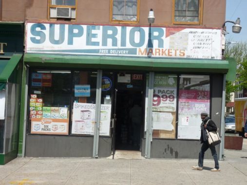
Greene Avenue issues east from Fulton Street at South Oxford and runs east and northeast to Ridgewood. At the corner of Cumberland is a venerable sign for Superior Markets.
Fort Greene, and Greene Avenue, are named for a fort built in 1776 at what is now Fort Greene Park’s central summit by General Nathanael Greene (1742-1786). The fort, originally named Ft. Putnam, aided in George Washington’s retreat after his defeat in the Battle of Brooklyn in 1776, and was reactivated during 1812 when a British attack was anticipated.
Cumberland Street south of Fulton Street is subnamed Atlantic Commons, for the now-25-year-old housing project built along it between Fulton and Atlantic Avenue. The development consists of handsome brick buildings reminiscent of early-20th Century Brooklyn housing stock.
The streets were outfitted with tall, bracketed “Flatbush Avenue” lampposts, but these have a difference: instead of a pointed finial at the apices, these feature small globes instead.
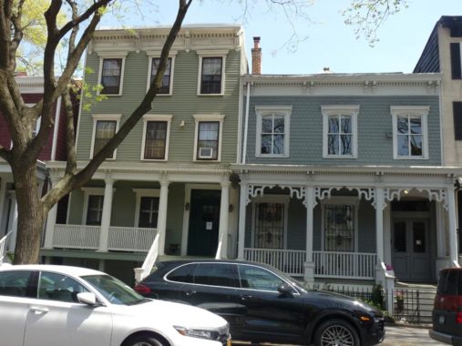
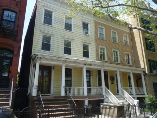
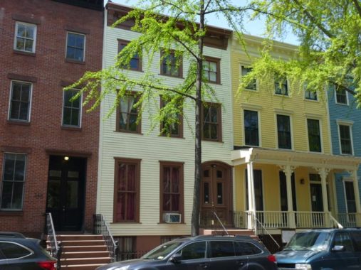
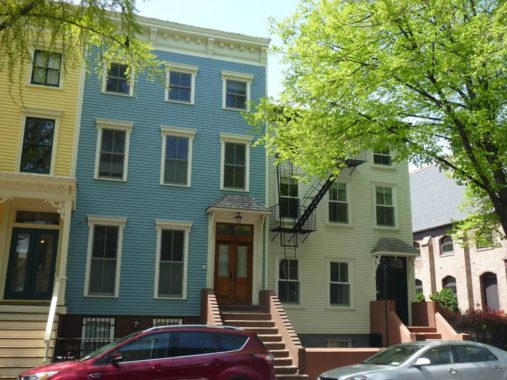
Turning north on Adelphi. Much of it is lined with attached brownstone buildings, the frequency of which gave the NYC Landmarks Preservation Commission the impetus to designate a good section of Fort Greene as a Landmarked District. Truth be told? I find this preponderance of brownstone a bit boring (though I wouldn’t turn one down if bequeathed one by a long-lost relative). Instead I find the older housing stock more compelling such as this pair just south of Lafayette at 331 and 333. Both are woodframe buildings combining Greek Revival and Italianate stylings, and went up in 1848 and 1855, respectively. The porches are of special note as 331 features Doric columns and 333 preserves its intricate decorative woodwork.
Here’s 329 Adelphi which has a corner facing on Lafayette. It was built in 1848 as well and also preserves the Doric-columned porch.
Here’s another woodframe classic, 321 Adelphi, this time north of Lafayette. It is another simple Italianate-style building that went up around 1855.
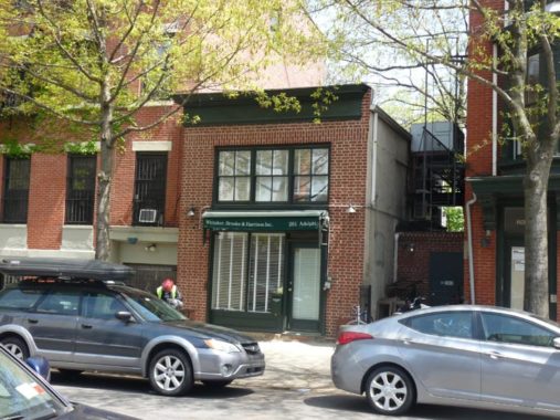
I also have a fascination with small brick residences, like this one at 261 Adelphi, north of DeKalb. The LPC report does not provide a date of construction, but I suspect it could have been a stable at one time.
This Greek/Italianate pair, 256 and 254 Adelphi, across the street from the Albert Lysander Parham Playground, were built by a local woodworker and architect Silas Burnett in 1852. The two porches are separate but were made to appear as one. Both have gotten metal residing.
Parham (1914-1990) bequeathed a quarter million dollars to NYC Parks to make improvements in the playground, which then gained his name.
240 and 238 Adelphi Street. Along with 236, the row was erected in 1867 for real estate speculators John French and Samuel Booth. Both have had metal residing, but 238 retains its porch with ornamental bracketing.
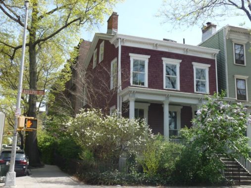
236 and 234 Adelphi. The latter went up in 1853 and was built for Edward Anthony, who owned a lot of property in Fort Greene at the time.
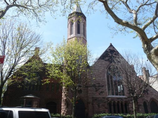
The Romanesque Revival Church of Saint Michael and Saint Mark, 230 Adelphi between DeKalb and Willoughby Avenues, was constructed in 1888 but has not been used as a church since 2001; while in a Landmarked district, its future use is uncertain.


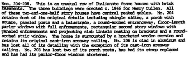
An exquisite trio, 204, 206, 208 Adelphi. Here’s the LPC Report entry:
North of Willoughby, Adelphi Street exits Landmarked territory and the difference is obvious, with new construction and lots more instances of alterations. Still, some gems turn up like the porched house at 185 Adelphi.
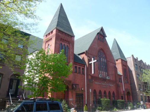
Plenty of peaks: The Institutional Church of God in Christ, 170 Adelphi, was built in from 1886-1890 in brick and terra cotta eclectic Queen Anne style as the Centennial Baptist Church [Lawrence B. Valk, arch.] . The Centennial Church was founded in 1874, a good quarter decade away from the approaching centennial, and held its first services in a skating rink! The reliable Montrose Morris has more details.
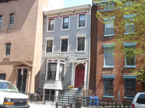
Another Italianate winner from the late 19th Century, 159 Adelphi, now squeezed between two larger apartments.
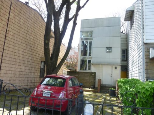
Here’s 134 Adelphi between Myrtle and Park Avenues, a small-footprinted building set back a considerable distance from the street. I suspected that was the case with whatever predecessor building was in the plot and my guess was correct: see 134 Adelphi in the NYC Municipal Records.


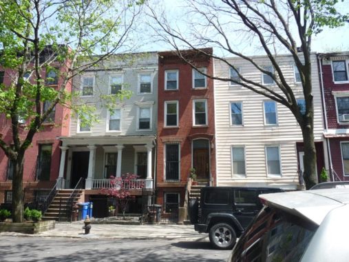
Though they’re resided into unrecognizability, these 3-story dwellings, #69-85, on the east side of Adelphi south of Park Avenue have a clean, streamlined look I can appreciate. I’ve seen much worse! Of course they used to look a lot different; see once again the Municipal Archive. My bet is that the modest houses once accommodated workers at the Brooklyn Navy Yard.
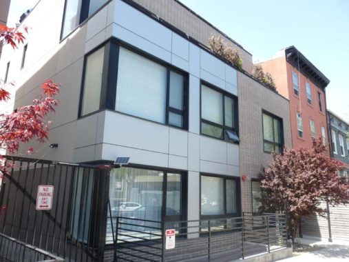
I’ll preface that I’m not an architectural critic and follow up by saying that I’m not as down as some of them are on the current trend of fronting buildings with flat paneling and large picture windows. I sort of like the look.


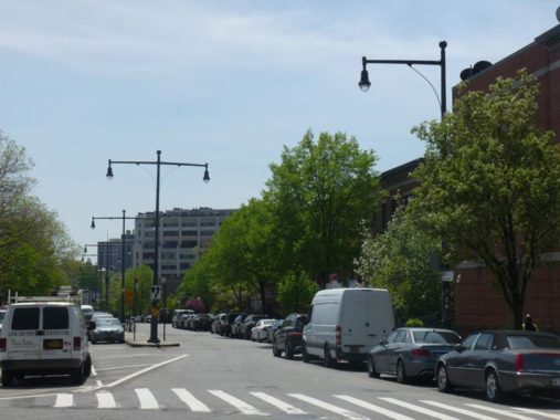
Brooklyn indeed has a Park Avenue, which runs between Navy Street and Brooklyn’s Broadway in the Fort Greene and Bedford-Stuyvesant neighborhoods. Since the late 1950s, the elevated Brooklyn-Queens Expressway has run along the avenue; its construction caused the destruction of buildings along its south side as well as some buildings on most of the cross streets.
While Park Avenue today is shadowed by an elevated roadway, it’s also hosted an elevated train — briefly. The route of Brooklyn’s very first elevated train, opened in 1885, which crossed the Brooklyn Bridge and zigzagged along several streets before settling on Lexington Avenue and Broadway traveled for a few blocks down Park Avenue as far east as Grand Avenue where it turned south. When Myrtle Avenue’s own elevated line was constructed in 1888, some of the Lex was considered redundant and so Park Avenue lost its elevated in 1889. Subsequently, the Lex branched off the Myrtle at Grand Avenue and then turned east on Lexington, connecting the Myrtle and Broadway Els. The Lex lasted all the way to 1950, and the Myrtle until 1969. The Broadway el is still in place, connecting to Manhattan via the Williamsburg Bridge.
The buildings on the north side of Park Avenue remained intact during the highway construction.
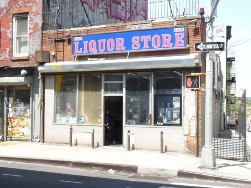
Park and Carlton Avenues. Some liquor stores have retained ancient neon signs, and others like this one simply state their purpose outright, without a name. I liked the bold red and blue sign in Egyptian Bold type.
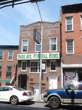
Park Avenue Funeral Home, 121 Park Avenue. It’s always been a funeral home, going back to the days when funeral homes were called “the undertaker.”
Flatbush Avenue was where the bracket posts known as the “Flatbush avenues” made their debut. This is the original design with a peaked finial. Note that they received a recent silver paint job — including the Bell light fixture.
Check out the ForgottenBook, take a look at the gift shop, and as always, “comment…as you see fit.”
5/12/19
2 comments
Adelphi Street is part of a grouping of streets south of the Brooklyn Navy Yard that were named for streets in London, including Hampden Street (now North and South Elliott Place), North and South Portland Avenue, North and South Oxford Street, Cumberland Street, Carlton Avenue and Adelphi Street. Further east we find Downing Street, but that may have been named for Coe S. Downing (D-Bklyn), an Assemblyman and later a State Senator during the 1830s when the street grid was laid out.
As to Park Avenue, it seems that it was named for City Park, now Commodore Barry Park, which was Brooklyn’s first park.
The reason for the renaming of Fort Putnam into Fort Greene is due to a later fort being called Fort Putnam, which was also named for General Rufus Putnam. The newer Fort Putnam served a much more important role in the war as it was part of the fortifications around West Point helping to secure the high ground overlooking the other fortifications and the Great Chain across the Hudson River. With the War or 1812 raging and the newer Fort Putnam still active, the newly reactivated fort was renamed after the commander whose units fought at the location- Nathanael Greene. Thus, the name living on to this day.
There was another Fort Greene in Brooklyn, located at between Nevins, Schermerhorn, Bond, and State Streets and was the largest fort among the forts in Brooklyn. It got renamed by the British, abandoned, and forgotten.