
It had been a good 6 years or so since I took a walk around Spuyten Duyvil, the hilly, almost mountainous, Bronx enclave tucked in its southwest enclave just above the Harlem River and Manhattan’s Inwood Hill Park. I sallied forth in freezing March weather after the only substantial snow NYC got all winter in 2019.
Spuyten Duyvil has been known as Speight den Duyvil, Spike & Devil, Spitting Devil, Spilling Devil, Spiten Debill and Spouting Devil, among other spellings. In Dutch, “spuyten duyvil,” the mostly-accepted spelling these days, can be pronounced two ways; one pronunciation means “devil’s whirlpool” and the other means “spite the devil.” The creek separating northern Manhattan from the mainland was eliminated in 1916 when the Harlem River was punched through by engineers to make the waterway navigable for heavy shipping.
In Washington Irving’s Knickerbocker History, a Dutch bugler vows to swim the turbulent waters of (then) Spuyten Duyvil Creek where it meets the Hudson during the British attack on New Amsterdam in the 1660s “en spijt den Duyvil,” or in “spite of the devil.”


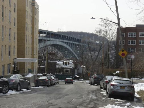
Taking the #1 train uptown, I got out at 231st Street, an elevated station above Broadway that opened in 1907. Despite renovations over they years, the stations along this route have been allowed to retain their chalet-like station roofs, as well as elaborate ironwork at the stairways allowing entry and exit and the serifed “UPTOWN” and “DOWNTOWN” lettering. The stained glass artwork is Felipe Galindo’s “Magic Realism in Kingsbridge.”
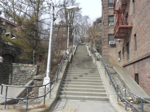
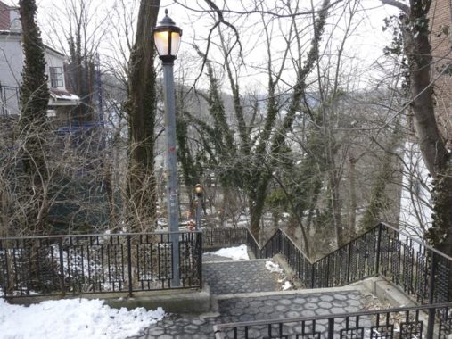
Shown here is an old friend, NYC’s longest step street, running a full three blocks between Irwin and Edgehill Avenues. The hills in Spuyten Duyvil are really quite steep and in some cases, too steep to have a road scale them directly. Some streets twist and turn to get around the hills. In addition, the presence of Tibbetts Brook, which ran aboveground until the early 20th Century, influenced the street pattern. In Curbed, Nathan Kensinger reports that there’s a plan to “daylight” Tibbetts, which now runs in the sewer system in Spuyten Duyvil.


I wish there was a map that located all of NYC’s step streets. By and large the Bronx is hillier than the other boroughs, with Staten Island a close second; a couple of years ago, I discovered a winding step street that scaled Ward’s Hill all the way from Victory Boulevard, and it’s hidden behind some storefronts so you’d miss it if you weren’t looking. I also found one in Woodside, a very rare Queens step street.

Private homes in Spuyten Duyvil, like this one on Johnson Avenue, edge right up to the step street in spots and indeed, some have entrance gates directly on the steps.
Private homes in Spuyten Duyvil, like this one on Johnson Avenue, edge right up to the step street in spots and indeed, some have entrance gates directly on the steps.

Edgehill Avenue, near the top of the step street, looks like a regular Bronx street, albeit one near the crest of a hill lined with Tudor houses. In reality it’s rather unusual. If you look at the map, it’s wishbone-shaped, with the only access on Netherland Avenue. It runs south until making a hairpin turn and running north again, ending at the step street.
Older maps tell the story. Edgehill Avenue was once supposed to also have a connection with West 227th Street, but that part of the street was never built or has been eliminated over time, with the Kinneret Day School now occupying its space.

The “top” or west end of the West 230th step street is at this magnificent Tudor with a wide back yard at Netherland Avenue. It too has a gate on the steps.


Netherland Avenue runs in several pieces in Spuyten Duyvil and Riverdale from Kappock Street north to West 261st Street at the Mount Saint Vincent campus (like the Brooklyn Navy Yard, it’d fortified like Fort Knox and I’ve never been on the grounds). Like other area streets, it’s named for the first European nation to control the New York environs.
It’s also at the top of a hill and, in fact, one side of the street is higher than the other. What to do? Where the grade isn’t that bad there’s a center median, but further south, it’s pretty steep and the west side of the road is separated by a stone wall. Elsewhere in Riverdale, Riverdale Avenue is carried along a similar wall.
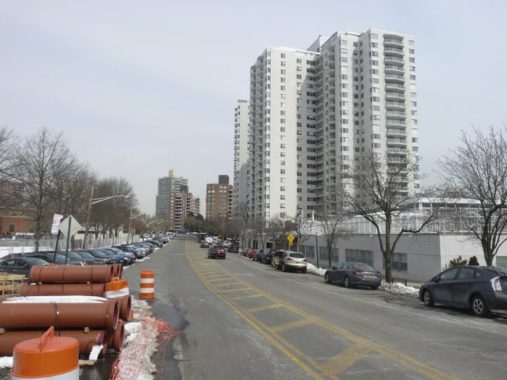
A feature of Spuyten Duyvil is that the bedrock is strong enough to support several high-rise apartment houses. The Century, at 2600 Netherland Avenue, is one.
The logo of the Riverdale Review is the the Riverdale Bell Tower at Riverdale Avenue, West 238th and the Henry Hudson Parkway, inscribed with the names of every person who served in World War I from Spuyten Duyvil and Riverdale.


Kappock Street twists and turns in southern Spuyten Duyvil on either side of the Henry Hudson Parkway. Like Cortelyou and Schermerhorn, it’s another one of NYC streets whose pronunciation makes no sense. Local denizens say KAY-pock while to me, the double P should shorten the consonant before it into CAP-puck. Along with Knolls Crescent it’s one of the few K-K interesections in NYC, and there are a lot of Kingsbridge this and that streets nearby.
The street name was suggested by historian Thomas Edsall after it was briefly Warren Avenue after it was laid out in 1895. Kappock is a shortening of the Native American (Algonquian) Shorakkappock, meaning “Sitting Down Place.” Edsall himself has a picturesque street in Spuyten Duyvil named for him.
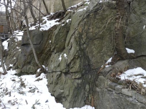
Exposed schist rock, like this outcropping on Kappock west of Netherland, is a common sight in upper Manhattan and the Bronx; it’s practically nonexistent in the other three boroughs.

Yet another step street, this one connecting Kappock Street and Knolls Crescent

For pedestrians, getting past the Henry Hudson Parkway on Kappock Street is a bit confusing. If you follow the sidewalk on the south side of the street you will find yourself on the Parkway itself! You actually have to cross to a center median and use a pathway that takes the street beneath the Parkway on this stone arch.
Edgehill Church


The AIA Guide to New York describes Edgehill Church Independence Avenue south of Kappock, a NYC Landmark, as having “a base of Richardsonian Romanesque, a top of Gothic Revival and a smattering of Tudor details.” Surprisingly it was designed by Francis Kimball to be a modest chapel for workers of the now-vanished Johnson Iron Foundry. Kimball also designed the brownstone Corbin Building at Broadway and John Street, now adjoining the new Fulton Street Transit Hub. Note especially the stained glass windows: they are by Louis Comfort Tiffany.
Isaac Gale Johnson was an original Spuyten Duyviler, founding a Civil-War era foundry supplying ordinance to the Union side. By 1890, the Johnson family owned much of what is now Spuyten Duyvil, but by 1923 they had closed and by 1938 the factory buildings had been razed.
The present location is in fact the second for the chapel. Its smaller first home of 1869 was at the present intersection of Johnson Avenue and Kappock Street, which marked the head of a no-longer-extant downhill lane known as Puddler’s Row. A “puddler” was a worker whose dangerous job involved managing molten iron as it was prepared for casting. It was the families of such employees at the Johnson Iron Works who were the focus of the mission’s work. The sprawling foundry, with smokestacks and night-reddening furnaces, occupied a peninsula reaching into the river from the base of Spuyten Duyvil cliff, just east of the shadow of today’s Henry Hudson Bridge. Lehman College
The Henry Hudson Bridge looms into view heading west on Independence Avenue. Accoding to historian McNamara, a Revolutionary War-era British cartographer thought Fort Independence was located in the Spuyten Duyvil-Riverdale area instead of further east in Kingsbridge Heights. When realtors developed the area they perpetuated this error and called one of the north-south streets Independence Avenue. Like its parallel streets, Independence Avenue runs almost all the way to Yonkers (it was fittingly called Yonkers Avenue at one point) but requires maddening detours as you proceed north.
The Henry Hudson Bridge, which carries the Henry Hudson Parkway over the Harlem River, is a steel arch bridge constructed in 1936 along with the Parkway. Designed by David Steinman, it was the longest steel arch bridge in the world when originally built. The best views can be had from within Inwood Hill Park. The original dime toll has now risen to $7.00 (as of 2019), with a hefty discount to $2.80 with EZ Pass.

Palisade Avenue, named for the New Jersey-side Hudson River cliffs called the Palisades, passes directly under the Henry Hudson Bridge.
This staircase at Independence and Palisade Avenues leads down to Edsall Avenue at the bottom of the hill, where there is access to the Spuyten Duyvil Metro North station.


I remember the southern view from the Half Moon Overlook being somewhat better in the past and perhaps it’s time for NYC Parks to clear some of the brush. The view permits a view south on the Hudson River and also of the swing bridge that spans the west side railroad tracks over the Harlem River. If you happen upon the overlook at the right time, you can catch the bridge swinging around to admit ships. The Overlook is named for explorer Henry Hudson’s ship.


Depending on if you live in a rear apartment, this building on Palisade Avenue commands spectacular views of the river.


If you look at the map, Independence Avenue splits in two separate sections west of Kappock, with both sections ending at Palisade Avenue. One section has addresses in the 2300s and the other in the 2500s. Walking along the northern section, more views of the Hudson River and the bridges appear, but only in the winter when the trees are bare.
Henry Hudson Park and Memorial


I’ve got several new shots of the Henry Hudson Memorial shaft in the park of the same name, located on either side of Kappock Street west of Independence. In the Revolutionary War era, Spuyten Duyvil was known as Tetard’s Hill, and the shaft is close to the crown of that hill. It can be seen from several blocks away especially from the north.
The spirit of Henry Hudson, it seems, seeps through Spuyten Duyvil, though the British navigator and explorer (1570-1611) apparently spent little time here when the Half Moon cruised by the region in 1609. Searching for a passage to the Pacific Ocean, Hudson wrote vividly in his log about the river that would bear his name. Hudson observed the islands that would be home to New York City, and in 1611, did find a northern passage to the Pacific when he sailed to Hudson Bay in Canada, but with disastrous consequences. His crew, Britons and Dutchmen, brawled ferociously and when they found themselves low on supplies on the frozen bay, they mutinied, setting Hudson, his son, and seven loyal crewmen adrift. Hudson presumably froze to death, while the crew starved or were killed in battles with the Inuit.
In Henry Hudson Park, at Kappock St. and Independence Ave., you will find Karl Bitter and Karl Gruppe’s 1939 memorial, a 16-foot statue of the explorer mounted on a 100-foot shaft (that had been erected 30 years previously, on the 300th anniversary of Hudson’s visit here). Hudson and his son are shown bartering with local Native Americans in bronze relief on the base. The Doric column is second only to the Prison Ship Martyr’s Monument in Fort Greene Park as New York City’s biggest.


I don’t think anyone is keeping statistics, but Independence Avenue probably has more varying widths than any NYC street, from pretty much standard-issue two-lane below West 231st, then quite narrow and winding for a block to West 232nd, here it begins again as a relative behemoth several feet to the east.
North of West 239th Independence narrows to two lanes once more. and then to a little trickle of a one-lane avenue north of West 246th, dead-ending north of West 247th. Its northern sector consists of a narrow two-lane road that runs past the Wave Hill Gardens front gate. The wider parts of Independence Avenue were created when the taller housing developments were built.
Whitehall, on Independence between West 232nd and 235th, is named for its striking white color but also shares a name with the old seat of Dutch rule in southern Manhattan in the 1600s for which Whitehall Street is named.
I’ll leave it here — I saw other infrastructural items in Spuyten Duyvil but will make them separate posts.
Check out the ForgottenBook, take a look at the gift shop, and as always, “comment…as you see fit.”
5/5/19
6 comments
Kevin, where is the step street in Woodside? I’m curious
A very nice article. I’m surprised you didn’t mention the Charlotte Brontë apartments.
You’ll have to wait several months, but an easy way to get onto the Mount St. Vincent’s campus is to attend a basketball game next season.
I am more surprised that there is no mention of Villa Rosa Bonheur, which is at the end of my street, and is featured in several of your photos. Talk about “forgotten”- this is one of the most important historical landmarks in Spuyten Duyvil, and is currently one of the most infamous due to the illegal demolition of it’s roof by the Developer who purchased it in 2017. Please see the Riverdale Press or contact me for more information. Thank you.
There are the remains of two Revolutionary War era forts in Riverdale. One each on either side of what is not Henry Hudson Parkway. One was located a little north of the Henry Hudson pedestal and statue. The other is due west of it one or two blocks west of the Parkway. Read the Kingsbridge Historical Society for details.
2475 Palisade Ave. is just about my favorite apt. bldg. in all of NYC ! Nice small size for an elevator building. NYC DR&IS has it built in 1932. My guess was late 1920’s. Wonder how much rents are with those views. Also, I love the winter scenery in NW Bronx !