
I am a Rememberer. I am skewered now and then for repeating myself or imitating Captain Obvious, but I am capable of remembering quite a few extraneous objects and occurrences. I don’t have total recall (actress Marilu Henner does) but I can recall what kind of street signs were used where in Bay Ridge in the 1960s; what kind of street lamps and lamp fixtures were in use on what street in the 1960s; what insult or slight I received from school bullies and teachers and in what class. That kind of thing. All this suffuses my consciousness whenever I return to my hometown, Bay Ridge.
I was back once again for an unexpected visit. I cracked a molar and so, I was forced back to the one last string that connects me to Bay Ridge: my dentist. A numbed mouth, some drilling and spackling, and a $450 extraction, and I was as good as new. I couldn’t have lunch till the filling hardened, so I was off for a ramble. I walked 5th Avenue and 4th Avenue to 99th, crossed over to 3rd Avenue, and walked back north, getting the N train at 4th and 60th. I managed to snap a few dozen images of interest, which will be presented here.


I lived in Bay Ridge for 35 years, 1957-1993, and have been going to the same dentist since 1964, and the same office of that dentist at 7500 4th Avenue since the 1980s. Yet, somehow, I had never noticed that this apartment building, at 375 76th Street at 4th Avenue, next door to the dentist, is guarded by several stone griffins on the roof. A griffin is a mythical beast used in heraldry and statuary, combining aspects of lions and eagles for the most part.
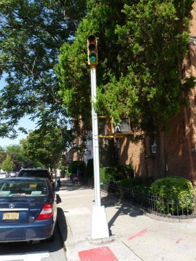
The slotted Donald Deskey lamp, introduced on Broadway near City Hall in 1958 and used widely from 1962-1980, was adaptable for whatever task it was needed for. Here at 4th Avenue and 76th Street, it holds a stoplight fixture.
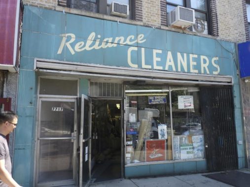
Reliance Cleaners, 7717 5th Avenue, has used this old school linoleum sign for as long as I can remember. It looks like a late 1940s or 1950s sign. But how to tell for sure? There’s a way.
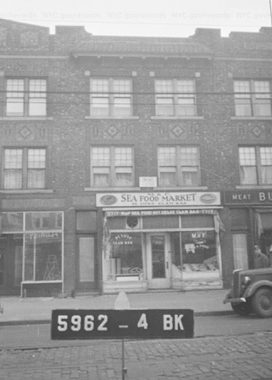
Here’s a look at 7717 5th Avenue in 1940 from the Municipal Archives, which includes a tax photo of every property in NYC in the 1940s and the 1980s. Reliance Cleaners wasn’t here in 1940 as the space was occupied by a seafood market. If you’re curious what NYC looked like in the 1940s, those resources are invaluable.
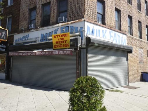
Throughout the 1970s and 1980s, a grocery called Milk Farm held down the corner of 5th Avenue and 81st Street, later replaced by a grocer called Beyer Farm. The Beyer Farm sign recently came down, and the building was recently for sale, with the space for rent; the Milk Farm sign is once again visible.
But how old was the Milk Farm?
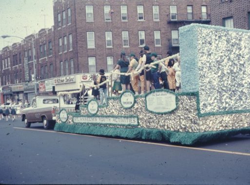
Here’s a photo from the old man’s collection of a float at the St. Anselm Youth Activities parade in 1966. (Where’s Bluto Blutarski when you need him?) In 1966, a kitchen cabinet store could be found in the space, so Milk Farm arrived a few years later.
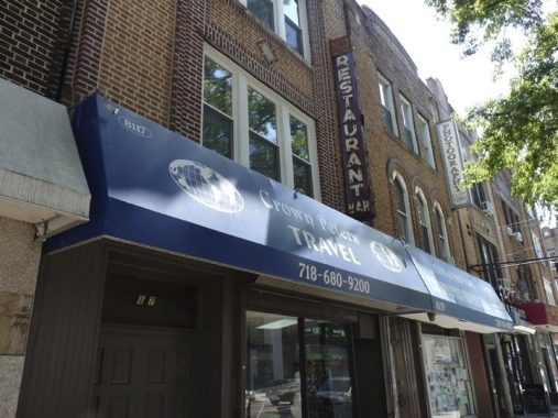
Crown Peters Travel agency has been a fixture on 5th Avenue, in various locations, since the 1960s. It’s presently at 8117 5th Avenue, but the ghost of a former tenant can still be discerned by the “restaurant” neon sign.
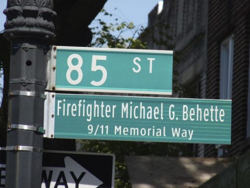
When I attended St. Anselm grade school from 1963-1971 we knew Tony Behette, who was a grade behind us. His brother, Michael, was a firefighter who drove up from Florida, where he was vacationing, when he heard about the terrorist attack on 9/11/01. After months working in the ruins, he was diagnosed with lung cancer, to which he succumbed in 2012 at age 55. The corner of 5th Avenue and 85th Street was named for him in 2014.

The apartment house behind the sign on the corner in the 1960s was home to a kosher delicatessen called Mendy’s. My father had a side job in the building as a custodian and I would assist him hauling garbage and emptying the dumbwaiters, which were still functioning well into the 1980s; for all I know they still do. A family friend, Mrs. Reilly, lived in the building and thus, the old man didn’t call it “505 85th Street,” he would call it simply “Reilly’s.”
Across 85th Street in the 1960s were a Friendly Frost appliance store, which was replaced by a Carvel ice cream shop. Behind that, at the corner of 86th Street, was the 64th NYPD precinct, a forbidding building I was happy to never be hauled into on suspicion of evildoing. In the early 1970s, Carvel and the precinct were wiped out so a nondescript municipal parking garage, which is still there, could replace them. The precinct is now on 65th Street off 3rd Avenue.
Here’s a somewhat lackluster view of 5th Avenue looking south at 86th Street, the neighborhood’s main shopping street and a main traffic route reaching all the way to Gravesend. Why did I choose to take the photo here? The reason is simple.
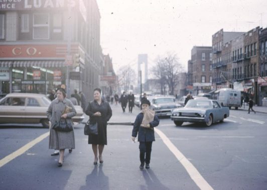
In December 1965, the old man got a photo of me crossing the street with a bagful of groceries at the same spot. The Verrazzano Bridge, opened in 1964, provides a backdrop. Throughout my youth, the F.W. Woolworth 5 and 10-cent store held down the corner at 502 86th Street.
Can I say something? People in general look rather younger, overall, in 2019 than they did in 1965. The two women in the photo are, I’d say, between 45 and 55 in age, but today, with more youthful outfits and hairdos, they would each younger than they do here. My mother did not wear heels to go shopping (she was uncomfortable in higher heels and generally wore lower ones) but this style coat and kerchief were staples for her. Had she been born later on, she would look completely different.
But what do I know about fashion…
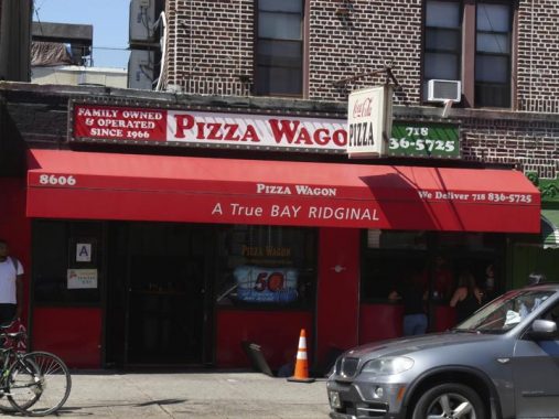
Pizza Wagon, 5th Avenue and 86th Street, has been a Bay Ridge staple since 1966, as the sign says. However, I have never eaten any pizza here. My friends may marvel at this but I did not become a real NYC pizza slice aficionado until rather later on, at the cusp of my teen years. I was a fussy eater as a kid and didn’t like the dripping oil from pizza slices. I couldn’t go in this day, either, as I was enjoined from eating anything after my dental work (I wanted to eat at the Blimpie across the street — one of the few remaining Blimpie sandwich shops in NYC).
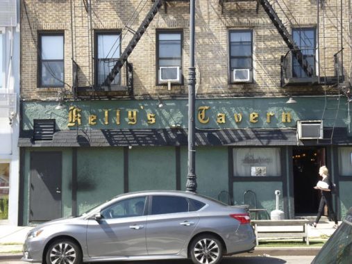
Kelly’s Tavern appears in the Bay Ridge-set classic, Saturday Night Fever, when Tony Manero and Stephanie are walking along 4th Avenue toward where she lives (Tony wants to walk her home, but she turns him down). Kelly’s has been there for quite awhile — in 1940, it was called Kelly’s Restaurant.
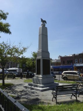
There are no shortage of World War I Memorials in Bay Ridge. This one is here at the triangle formed by 4th and 5th Avenues and 94th Street. The names of those soldiers who trained at Fort Hamilton and served or passed away during World War I are inscribed on a granite shaft erected in 1917.
For years the triangle was known as Pigeon Park, both for the fowl that flocked in the park and for the homing pigeons used to carry messages during WWI and WWII, but it was formally named Fort Hamilton Triangle by Parks Commissioner Henry Stern in 1998. It is currently surrounded by a locked gate to discourage vagrancy in the park.
When Bay Ridge streets were laid out in the 1800s, 4th and 5th Avenues came to a meeting place here, with only one avenue proceeding south to the Narrows. 4th Avenue was selected to proceed south, presumably because it’s the “senior” number.
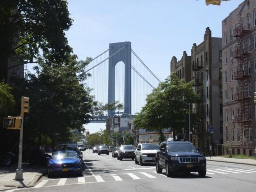
The Verrazzano-Narrows Bridge, seen from 4th Avenue and 97th Street. My own experience watching the bridge’s construction has been referred to in various posts on numerous occasions, so I won’t belabor it again here, but if you haven’t read it, here it is, complete with vintage images from 1964.
When Googling the bridge, it’s best to spell it without the extra z. Historical groups succeeded in getting the extra z formally included in 2018, though the explorer himself spelled his name in various ways — as was the practice until increased literacy and printing technology standardized the spellings of proper names and places.
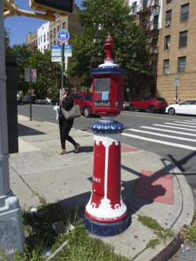
The design of NYC’s older fire alarm boxes was settled upon in 1913, with some variations. The ornament on top is supposed to be a torch, but I’ve always called it an ice cream cone. While many still work, the city stopped servicing others as people increasingly rely on calling 911 when fires break out.
For the past decade, security guard John Colgan has been repainting some of the boxes with additional colors and designs (when the city repaints a box, it’s all red). This one can be found at 4th and Marine Avenues; in Bay Ridge, Marine Avenue replaces 98th Street between 3rd Avenue and Fort Hamilton Parkway.


315 99th Street, off 3rd Avenue, stopped me in my tracks, with the pair of guard dog heads at the entrance. Were they there in 1940? YES.
Brooklyn’s 3rd Avenue is one of the oldest roads in the borough, or rather, a straightened version of one of its oldest roads. As early as the 1640s there was a wagon trail that ran from the Kings Highway (today’s Fulton Street) southwest to Yellow Hook, today’s Bay Ridge. Called the Gowanus Road, it is mentioned in documents going back as far as 1642, when Peter Stuyvesant’s predecessor William Kieft was New Amsterdam’s Director General.
The British Army marched along the Gowanus Road in 1776 before engaging the patriots in the Battle of Brooklyn and Lord Sterling and his men fled along it during his retreat.
As Brooklyn’s street grid began to take shape, Gowanus Road was closed in sections between 1840 and 1853. In 1848, the first section of 3rd Avenue proper in what was still the Village of New Utrecht was opened from 60th Street to 79th Street. Very early on, horsecar lines and later, trolleys plied the route to downtown Brooklyn. Trolley service, the #37, lasted until 1942 and was replaced by buses. The B37 was retired for a couple of years in 2010, but has now returned.
I don’t know much about magnificent 185 Marine Avenue, above, except its lighthouse-like tower looks out over the Narrows. It’s got extraordinarily varied and pointed brickwork. It was completed in 1927. It takes advantage of the pointed corner made possible by Marine Avenue’s turn to the northwest at 3rd Avenue.


In 2016, the corner of 3rd Avenue and 74th Street was named Ragamuffin Way in honor of Bay Ridge’s annual Ragamuffin Parade, the only NYC parade that specifically is put on for children. Since 1966, when it was on 4th Avenue, children have donned Halloween costumes and paraded up a Bay Ridge avenue, accompanied by marching bands and floats; similar “ragamuffin parades” had been a NYC tradition in previous decades. It so happens that the old man snapped a couple of images from the very first Bay Ridge Ragamuffin Parade.
Here’s some Ragamuffin Parade video. In 2019 the parade will be on Saturday, September 28 on 3rd Avenue from 76th to 92nd Streets. If you and your child wish to participate, preregistration is necessary.
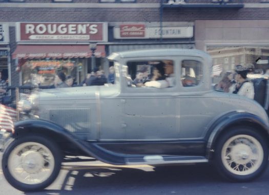
Here, during the Ragamuffin Parade in 1966, a vintage car cruises past Rougen’s Bakery at 4th Avenue and 85th Street. Along with Ebinger’s on 86th, Rougen’s cookies and cakes caused us all to be a bit bigger than preferable during my pre-teen years.
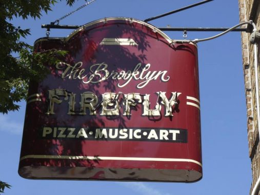
The Brooklyn Firefly opened in 2016 at 3rd and Ovington Avenues, and is both an “artisanal pizza” place (that serves drinks) and a concert venue. It took the place of the Yellow Hook Grille (whose name was a homage to Bay Ridge’s former name) and before that, Lento’s.
Me, I was attracted to its old-school neon sign, which is either brand new or is a rahabbed older sign. Either way they did a nice job recreating the look of the 1940s with it.
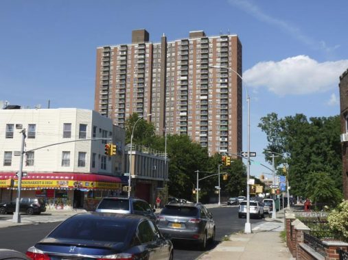
The Bay Ridge Towers, a pair of 30-story cooperative apartment towers on the border of Bay Ridge and Sunset Park alongside the Bay Ridge LIRR cut along 65th Street, went up from 1971-1972 and immediately became the tallest buildings in the neighborhood, changing irrevocably the appearance of things as you traveled north on 3rd or 4th Avenues.
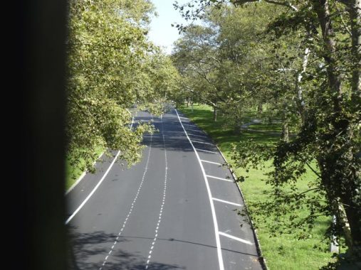
Awkwardly-named Shore Road Drive is actually the original northern end of Shore Road, which today now runs from 68th Street southwest along the Narrows to 4th Avenue. Like the rest of Shore Road, it was built as a pastoral carriage road for leisurely shore-side traffic, and gently curves and twists from 4th Avenue and Leif Ericson Square to the junction with the Belt Parkway, built here in 1940. It connects the Belt Parkway with 4th Avenue and 67th Street, running through Leif Ericson Park.
Shore Road Drive kept its collection of type-G Corvington posts well into the 1970s, long after surrounding streets had replaced them.
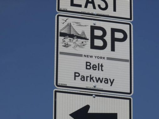
New signs have gone up identifying NYC’s parkways system created by Robert Moses in the 1930s and 1940s. Parkways are different from expressways, as the overpasses are too low to permit trucks and buses from using them, thus restricting them to autos and motorcycles. The signs illustrate an aspect of the parkways they are identifying.
The Belt Parkway sign shows the Verrazzano-Narrows Bridge, but does stretch the truth a bit showing a public beach near it. There are small beaches in the bridge’s vicinity, especially near the Bay 8th Street entrance/exit to the Belt, but the Narrows with its currents is not conducive to public bathing and thus its small sandy shoreline areas are fenced off.
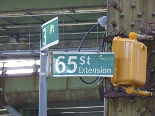
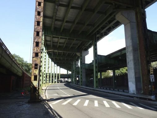
When the Gowanus Expressway and Verrazzano Bridge were built from 1959-1964, a spaghetti cluster of roadways were built along 3rd Avenue between 57th and 65th Streets that also connected the Belt Parkway into the mix. A surface roadway was also built under the elevated expressway between 3rd Avenue and 65th Street. I’d never seen it identified with a street sign before, but today, I did: 65th Street Extension.
Hey, they should have named it for me! I grew up in Bay Ridge.
Check out the ForgottenBook, take a look at the gift shop, and as always, “comment…as you see fit.”
9/8/19
12 comments
How do I subscribe to your website/blog and how do I learn of upcoming tours?
I’ve scoured the website/blog, but can’t seem to find any info on this?
Many thanks!
Jim
Don’t know about subscribing to the website, but for tours just go to the top and find “forgotten tours/tour schedule” and then “FNY 2019 tour schedule.” You can use the “book a tour” box on the right of every page to pay by paypal in advance for a tour, but they are all walk-up-able too (I’ve done both). I do recommend them as Kev is always fascinating and you get to meet odd and interesting people along the way.
The tax photo archives, in general, are a valuable resource when researching neighborhoods. The 1940 photos, in particular; because the composition and resolution of those photos is vastly superior to the 1980s images. The 1980s photos are poor quality and look like the city handed high school students Kodak 110 Pocket 20s and told them, ” Just go out and take pitchers of buildings, O.K.?”
“…which includes a tax photo of every property in NYC in the 1940s and the 1980s.”
That is incorrect. A glaring and frustrating problem with both series is that there are a sizeable number of street addresses that aren’t photographed. In my research, I’ve run across many instances of no available images of buildings I had a particular interest in to be found in either series. To compound this problem, many images have been incorrectly labeled with incorrect addresses. I have viewed images of buildings I am familiar with and found that the address and other related info, such as construction dates, are completely wrong. sometimes, this affects the address of every building on a specific street block.. If one isn’t intimately familiar with a specific neighborhood, you wouldn’t be aware of this. The only way to verify an address is to check the block and lot numbers using DOB’s Building Information Search:
http://a810-bisweb.nyc.gov/bisweb/bispi00.jsp
This will verify whether the image information is correct. Also, cross-checking NYC Fire Insurance, Topographic and Property Maps will aid in discovering any possible discrepancies.
https://www.nypl.org/collections/nypl-recommendations/guides/fire-topo-property-maps
Fourth and Fifth Avenues between 85th Street and Shore Road follows the route of Stewart Avenue, which once ran from Shore Road to about 66th Street. This was done at the time of the adoption of the street grid, which incorporated the previously developed layout of Fort Hamilton Village. Aside from the portion incorporated into Fourth and Fifth Avenues, much of Stewart Avenue has been closed, with the exception of a block between Ovington Avenue and 71st Street, and two blocks between 72nd and 74th Streets. (I believe FNY did a post on Stewart Avenue)
Great stuff. What I like in the 1965 pic of you crossing the road is how junky the 1962(63?) Lincoln Continental looks already. It’s barely 2 years old I’d guess.
Enjoyed your photos and your narratives… great work!
“Parkways are different from expressways, as the overpasses are too low to permit trucks and buses from using them, thus restricting them to autos and motorcycles.”
For the most part. I believe there’s a section of the Meadowbrook Parkway and/or Northern State Parkway which, when they rebuilt the overpasses, made it so buses could use it going to and from Roosevelt Field Mall.
The precinct on 86th St. and 5th Ave. was the 64, not the 68. The boundaries of the 68 were changed to cover what the 64 previously did.
“I lived in Bay Ridge for 35 years, 1957-1993”
Are you sure you did?
Impressive shade game there, Clyde, for getting a digit wrong on a precinct that moved out in 1971.
Thank you so much for the step back in time. I was born and raised in Clinton Hill section of Brooklyn and moved to Bay Ridge in 1962 . Married from our home on 93 and Shore Road. During my marriage I lived 67th Street ,72 and 99th streets. My children attended St Patrick Catholic school 95 and 4 th. Walked and shopped 86th Street for years. My mother in law owned loft candy store on corner of 86 th and 5th in the mid 1970’s
Sitting at home in Dallas after Thanksgiving thinking about making some bread pudding. I found your site after typing in Rougen’s bakery 85th & 4th near the subway exit which had the absolute best bread pudding ever and I was caught up in the nostalgia. I lived in Bayridge from 52 until 74 and the images took me back. I still need to find that Rougen’s bread pudding recipe – they poured Metaxa brandy over it if requested. I believe it was only available on Sundays and they used their leftover danish in it, making it sumptuously rich. Thanks for the stroll down memory lane.
My dad owned a deli on 5 th Ave in the sixties. I marched in the raggamuffin parade I guess in 1967 and 1968 before we moved out to Long Island. Thanks for the memories.