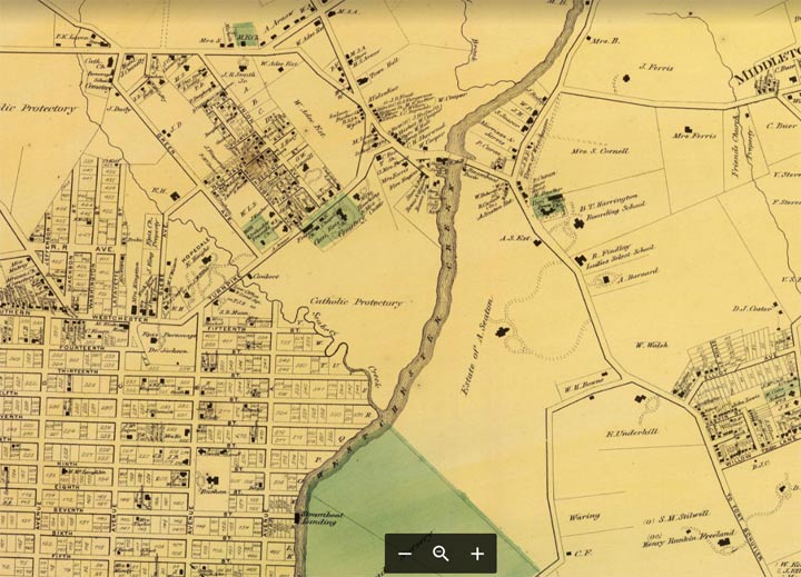
The FNY Tour of September 8, 2019 took us once again to the Westchester Square area, the site of two previous tours. There’s a lot of history concentrated in the same area, such as a river crossing where the patriots thwarted the British redcoats; an Anglican parish, St. Peter’s, dating to the mid-1600s; and the Huntington Library, whose interior seems to be preserved the way it was in the 1930s. The tour was accompanied by Sandi Lusk, the director of Westchester Sq-Zerega Avenue Improvement Inc. who supplied this map of the area circa 1900.
On the top right is the crossroads of Westchester Square, where East Tremont Avenue meets Westchester Avenue. The “town” recently celebrated its 350th anniversary, having been settled here, as Oostdorp (‘east village’) by the Dutch in 1654 and taken over by the British with the rest of New Amsterdam in 1664. It became a busy port along Westchester Creek, which hastened its development; by 1693 St. Peter’s Episcopal Church was founded. The parish is still in existence. During the Revolution, patriots dismantled a bridge over the creek, delaying British advancement (the present-day bridge carries East Tremont Avenue).
The gridded area to the southwest is the former town of Unionport. Unionport, laid out in 1851, was among the first towns in the Bronx to adopt a grid street system, and streets were named simply, by alphabet for north-south streets, by numbers east to west. Avenue A is now Zerega Avenue, Avenue B is now Havemeyer Avenue and so on. Its name seems to have something to do with the navigability of the adjoining Westchester Creek, and at one time it was hoped that a major port could be built there. A remnant of this nomenclature can be seen at PS 36 on Castle Hill Avenue, between Watson and Blackrock Avenues. The walls of the school bear the names Avenue C, 8th Street and 9th Street, the streets’ former names.
Today Unionport is contained within the neighborhood of Castle Hill, named for a slight elevation at what is now Lacombe and Castle Hill Avenues noticed by 17th-Century Dutch explorer Adrian Block, who thought it resembled a castle.
Check out the ForgottenBook, take a look at the gift shop, and as always, “comment…as you see fit.”
9/9/19


4 comments
I grew up on Herschell St. so that map is so very interesting to me. Is there a way I could source a more readable copy? What year is the map from? The house I grew up in is still there-built in 1910 I believe. Attended PS 12.
I lived on Blackrock Ave from 1072-1984. I never knew this! Fascinating!!!
Don’t forget that one of Parkchester’s two main thoroughfares is Unionport Road (the other is Metropolitan Avenue).
https://www.nytimes.com/real-estate/usa/ny/bronx/parkchester/building/1594-unionport-road/12256
For more history on Westchester Creek, read my Hidden Waters page on it.