
Probably no other Brooklyn neighborhood has as many ghosts as Coney Island, from Luna Park to Steeplechase to George Tilyou to the Elephant Hotel. For over sixty years, Surf Avenue’s trolley poles that carried electric wires on trundling trolley cars remained in place as if frozen in time. Nathan’s is still where it’s always been, at Surf and Stillwell, joined in 2019 by a new incarnation of Feltman’s — which invented the mild sausage on a roll treat in the first place. Despite being vastly shrunken over time, in the summertime Coney Island is Brooklyn’s playground in the warm months, welcoming thousands of visitors to the rides, the beach, the surf, the hot dogs.
For the Coney Island of the late 20th Century, the one still of recent memory, there’s no better chronicle than Charles Denson’s Coney Island Lost and Found. The longtime Coney resident discusses what it was like to live in the gradually devolving Coney Island before it was somewhat revived in the late 1990s and early 2000s by the arrival of things such as the Coney Island Museum and Mermaid Parade.
There’s another Coney, of course, one home to residents year round, many low-income, some middle-income, to over a dozen high rise housing projects constructed in the mid-20th Century: the Brightwater Houses; Luna Park Houses; Warbasse Houses; and Trump Village, constructed by Fred Trump, father of “The Donald.” Before any of thee housing projects were built, Coney north of the elevated train serving the D, F, N and Q trains was home to a cluster of small streets that had modest one or two family residences, and even some larger apartment buildings, that were wiped clean by the hand of Corbusian towers in the park developments.
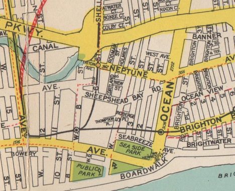
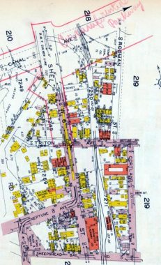
Here’s a Geographia Maps overview of the Coney Island area in 1938. I’m concentrating on the area east of West 8th ad west of Ocean Parkway, north of Surf Avenue. Right off the bat you can notice a couple of things. At that time Sheepshead Bay Road ran east of West 6th Street, continuing on to Ocean Parkway (Trump Village occupies that stretch now). Neptune Avenue wasn’t continuous — it ran to West 6th, then you needed to travel north and then head east on it again. When Trump Village was built, Neptune avenue was straightened.
West 1st through 3rd Streets continued south to Seabreeze Avenue. Only pieces of those streets are there today, mainly to serve traffic going to PS 100, still there on West 3rd. The thick yellow line at the top is the new Circumferential Parkway, rendered rather crudely here. It opened in 1940 and its name was quickly shortened to Shore Parkway, also known as the Belt Parkway.
Needless to say the E. Belcher Hyde street and property maps produced in the early 20th Century are much more comprehensive, listing every street, house, house number, trolley track, elevated train, you name it. If you’re a true map maven I urge you to check the zoomable plates in Historic Map Works, where they are available for purchase without watermarks.
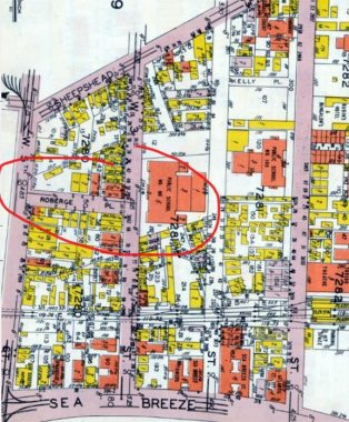
The section shown here is between West 1st and 5th Streets north of Sea Breeze Avenue. All these streets have been replaced by Trump Village, with the exception of the el right of way, PS 100 (the large orange box in the center) and West 5th, which continues as a major north-south street.
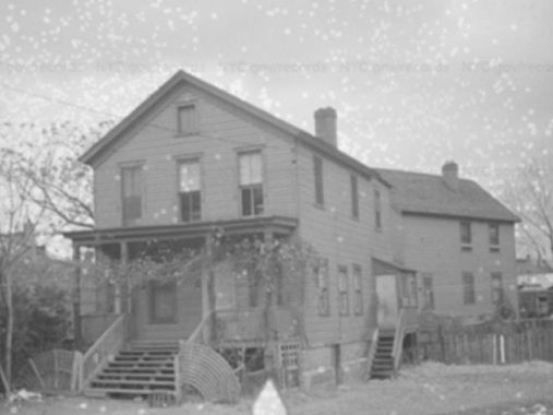
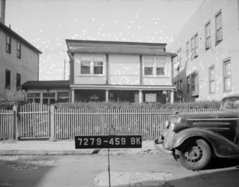
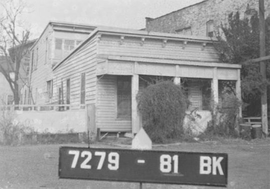
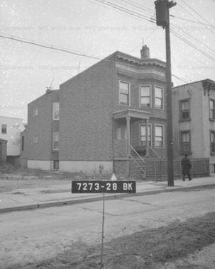
Roberge Place was a short one-block street running between West 3rd and West 5th (West 4th did not extend this far south). It was lined with modest one and two story houses like this one. The NYC Mnicipal Archives tax photos from 1940 is a true time machine here, transporting you to a completely vanished past, Every building on every lost street was captured by the camera.
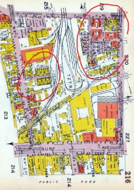
I’ve noted that Sheepshead Bay Road used to extend east of West 6th. At the top of the map you can see its intersection with West 5th Street. Just south of SBR was a large trolley car yard. South of Surf Avenue was the familiar amusement area.
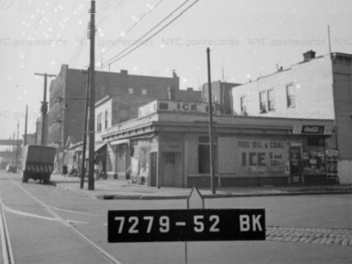
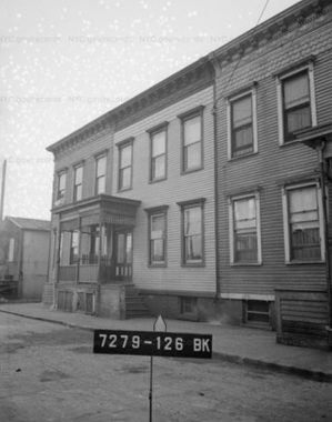
522 Sheepshead Bay Road at West 5th Street. Not all dwellings had a refrigerator in 1940 and ice purchases were still important.
The upper right area of the map is interesting. There was a small interconnecting grid of paths called Nass Walk, sands Walk, and Stern Walk. Along these paths you would be able to find small attached houses, but also the only large apartment houses that were torn down to make way for Trump Village.
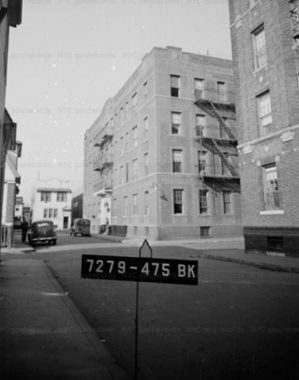
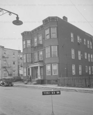
Nass Walk, looking south toward Stern Walk. You can see the demolished Lincoln and Sands Apartment buildings here.
A small two story building on Sands Walk.
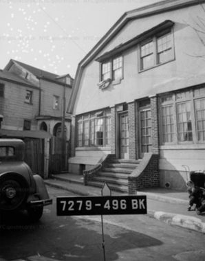
Attached pair of houses with a gambrel roof on Stern Walk.
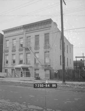
Thompson Place was a short dead end issuing west from West 5th Street south of the Nass-Sands-Stern grid. The short Place dead ended at the trolley yard. This was #19 Thompson Place, the last building on the street. The sign in the foreground marked the block and lot number.
Kister Court ran east from West 8th Street north of Surf Avenue.
When I was a kid age 11, I bicycled all the way down to Coney Island from Bay Ridge, my first relatively long ride. I wound up under the el at West 6th and a street then under demolition, Triton Avenue. It ran from Shell Road east under the el and then was assumed by Neptune Avenue. The name fit right in with Coney nomenclature, as Triton was the conch blowing merman son of Neptune. The avenue lasted longer than it may otherwise have because a trolley line ran on it.
In the map above, only a rerouted Neptune Avenue remains, as does West 6th which runs under the el carrying the F train. The Warbasse Houses and Trump Village now occupy everything else, wiping out Triton Avenue, Rodman and Holmes Streets (which ran north from Triton) and Cortland street (between Sheepshed Bay Road and Neptune Avenue).
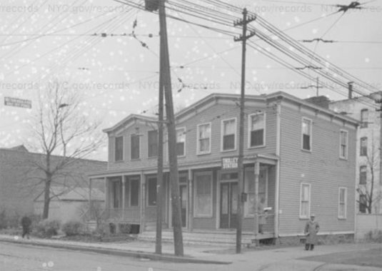
A trolley station stop and attached houses on Triton Avenue.
A single family dwelling on Cortland Street.
Attached house and radial wave streetlamp on Holmes Street.
A pair of walkup apartment buildings on Rodman Street.
Today, these streets; their dwellings; the people who lived there — are distant memories and by the next generation will cease to even be memories. The Coney of 2020 has little resemblance of that of 1940.
Check out the ForgottenBook, take a look at the gift shop, and as always, “comment…as you see fit.”
1/15/20
16 comments
When my son was younger, I took him on what we called “adventure walks”. We would walk through particular neighborhoods and I would tell him about the history, point
out local landmarks, etc.; essentially a walking history lesson. There were areas where houses were demolished and replaced by commercial structures, lots and
projects. My son said that it’s like the people who once lived in those long vanished houses never existed because nobody remembers them anymore. From the mouths of
babes…..
Just would like to say that Sheepshead Bay Road ran from West 8th St. and NOT West 6th St.,
to Ocean Parkway. I lived there, I know…
Funny I was just telling some one this morning about Coney Island. I worked for one of the
Contractors that built the New Aquarium in the late 80s. It was all set for it to open in a
couple of weeks when the “No Name Storm”
hit over the weekend. It did millions of dollars
to all the Fish Tank Pumps and Filters, Electrical wiring, Four feet high of every wall had to be removed Plus all the carpeting.
Set the job Opening back 6 months, all because the Flood Doors Designed for just
this occasion were left open.
As long as Trump Village isn’t ever renamed The Hillary Houses…
If I recall correctly, the Whitewater project in Arkansas was the original Hillary houses. Send my regards to Dr. Martin Abend (deceased) & everyone else.
I remember the warren of small frame houses from when I was a kid. My dad and I would drive through them while we waited for my mother to leave Steeplechase Park. There were so many old houses. Thanks for posting
this, brought back a lot of memories.
I started at Abraham Lincoln High School in the Fall of 1962. Before my parents moved to TRump Village in 1964, I would take the Culver line (then the “D” train) to Van Siclen (not then renamed Neptune Avenue.) Back then, the area had been cleared of its former structures, and was just a plateau of wind-whipped sand punctuted by the pile drivers beginning the underpinnings of what would be Trump and Warbasse. The wooden station bridged a clearly-marked Triton Avenue and Shell Road, the other streets having vanished, Neptune Avenue not yet having been relocated a block south, nor had today’s West Brighton Avenue been ploughed through. Other than the EL structures themselves, the only buildings standing in the quadrangle bordered byOcean Parkway, Shell Road/West 6th Street, the Belt Prkway and the Brighton El were Lincoln itself, the Brighton Laundry, the 2 P.S. 100 buildings (one of which was a dreaded “600 school”) and the Catholic Church and the much-missed Tuxedo Theater, both on Ocean Parkway. West 5th Street was half its current width and still sported wooden telephone poles, although the utilities themselves had been relocated underground in advance of the new high-rise buildings. And I believe the trolley tracks still ran into the old trolley barn, the site of the current MTA power sub-station and parking lot.
I moved to Luna Park in 1962 from Williamsburg. I recall all the locations you mentioned. My building over looked the 60th precinct and the fire station on W 8th St. Down the block on W8th St. was the Bonomo’s Turkish Taffy factory. I recall the constant banging of the pile drivers knocking huge metal pipes into the foundations of what would be Trump Village and Warbasse.
Pointless non-sequitar political comments should be removed. They most certainly add nothing to the discussion.
While Neptune Avenue was being rerouted, there were two distinct Neptune avenues. The temporary name for the new Neptune never was “new Neptune Avenue“. That is the Neptune Avenue that exists today.
I started in Coney Island in 1939. It sure was diffrent then. I rode on a float in the last Mardi Gras, 1954.
The Aquarium opened in 1957.
Looking for photos of Abe Fleminger’s Rooming House, 2922 W. !5th St., across from Gargiulio’s Restaurant, near Surf Ave.
2922 W. 15th isn’t standing anymore but I’d love to see old photos of that building. It was located right next to Tony’s Furnished Rooms.
Thanks so much.
I grew up on Rodman Street in Richard Court .
We lived at 5 Ricard Court
This is the best website