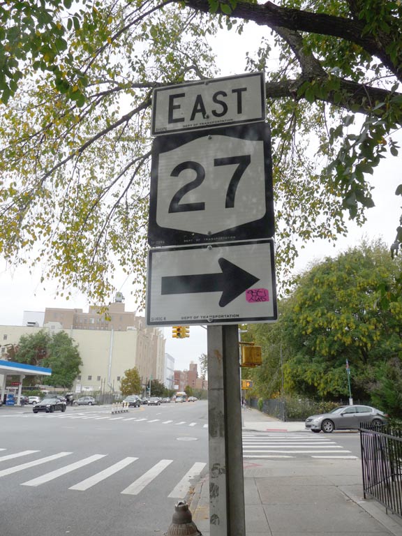
One of these days… months … years I’ll write a Forgotten New York page on all the New York state routes that run along local streets. There are a number of them, but not a sufficient amount to produce a page that’s much too lengthy for me to write, and for you to read. I was stalking around in Prospect Park the other day and after having just left a friend who lives near the park, I spotted this sign on Coney Island Avenue just south of Caton. (OK, I had known about this sign for some time, and check to see if it’s still there every time I’m in the area.)
New York State 27 runs in all four counties on Long Island. It begins at the junction of the Gowanus and Prospect Expressways and has a somewhat convoluted route along the Prospect and Ocean Parkway, then west on Church Avenue, north along East 3rd (East 5th traveling south; side streets are one-way) then east along Caton to its junction with Linden Boulevard, then east along Linden to the Belt Parkway. When the Belt turns north in Rosedale, NY 27 follows Sunrise Highway all the way out to the South Fork and then it mostly follows the Montauk Highway, ending at Montauk Point in the state park of the same name.
NY 27 was designated in 1927 in Nassau and Suffolk Counties, and was extended west into NYC streets in 1934. Its current route along Linden Boulevard, however, wasn’t designated until the 1960s, and after several years extending north to the Holland Tunnel, it was cut back to begin at the Gowanus Expressway in 1973.
For the most part, NY state routes are meaningless in the five boroughs, only gaining importance far outside the city where they serve as main routes absent the presence of interstate or US highways in their vicinity. That, I suppose, is why I enjoy locating them.
Check out the ForgottenBook, take a look at the gift shop, and as always, “comment…as you see fit.”
10/26/20


6 comments
Route 27/Sunrise is a very strange road on Long Island. In Nassau County it’s a multilane surface road with a quadrillion endless traffic lights, right next to the LIRR Babylon line most of the way. Juat before reaching the Suffolk line it turns north away from the LIRR, and within a couple miles, right about where the Central Branch crosses, it turns into a limited access highway with no lights all the way to Southampton.
Sunrise Highway was originally a conventional arterial road with traffic lights all through Suffolk County. The freeway portion, beginning east of Lindenhurst at Babylon Town Hall, was built in stages between the mid-1960s and the mid-1990s. The original NY State plan was to rebuild it as a freeway to the west all through Nassau County as well, but that project was shelved for reasons obvious to anyone who knows the area (I’ve lived a mile south of Sunrise for 42 years). Sunrise Highway bisects many business districts and is parallel to twelve LIRR stations from Rosedale to Massapequa Park. Rebuilding it as a freeway west of Lindenhurst would be extremely disruptive, so the plan was shelved early on. Cars can use the Southern State Parkway about a mile north; trucks must still use Sunrise Highway.
Eastbound 27 Exits the Prospect Expressway at Exit 5. Several NY 27 signs on East 5th Street at Greenwood Ave., Fort Hamilton Parkway and Caton Ave. Then left on Caton through Kensington and Flatbush to Linden Boulevard.
Westbound appears to make the left from Caton onto Coney Island Ave., then right on Church Ave. to Ocean Parkway, then a right onto the Prospect Expressway.
This is as near as I can tell. Signing is somewhat inconsistent, with some areas heavily marked, and others not so much.
I think I remember a lot of State Rte. 9A signs on the west side-maybe Riverside Drive or Henry Hudson Pkwy.
I remember going to day camp for several of the years between 1960 and 1965. The camp (school) bus would leave the East Flatbury Rugby YMHA and take us to Hempstead Lake State Park. We went down Linden Blvd and South Conduit Blvd to Sunrise Highway, then left on Peninsula Boulevard. No parkway for us, of course. This was terra incognita for us, and my eyes were as big as saucers.Note that on some days they would take us to Long Beach, but I don’t know how we got there.
NY 440 is on S.I. The West Shore expressway and MLK. Outerbridge Crossing up the west shore to the SIE for 1 exit and connects to the MLK to the Bayonne Bridge back to NJ. Before the SIE, Forest Ave. was the main route to the Goethals Bridge. It was NY 439. These signs have been removed. Some Esso maps from the 1950s show 439.