

For my purposes the one-block stretch of 101st Avenue between Forbell and Drew Streets is one of the most unusual in the city. Why? Well, it’s the only street in the Queens street numbering system that’s completely within Brooklyn. It used to be easier to tell where the undefended Brooklyn-Queens border was, especially between the years 1964 and 1984 when NYC street signs were color coded by borough … you crossed from Brooklyn into Queens when the signs turned from black to white. Ultimately, this arrangement wasn’t really a factor. Only on two occasions do NYC boroughs have land borders: Brooklyn/Queens, and a very short stretch of Bronx/Manhattan in Marble Hill.
I have been in these parts before. In the same vicinity, western Woodhaven/Ozone Park, I checked out 95th Avenue which is actually in three separate New York counties. However: the piece of 101st Avenue shown here on the title card, between Forbell and Drew Streets, is totally and undeniably within Brooklyn. On this page, I’ll try to illustrate how that happened.
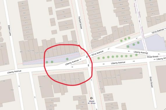
An excerpt from OpenStreetMap in June 2021. You can see the Brooklyn-Queens line on Drew Street (showing county borders is a courtesy that Google Maps does not vouchsafe) and then running east along Liberty Avenue. If you look carefully, you can see the Brooklyn-style house numbers 11 through 35 on the north side of 101st Avenue, and then, once in Queens, 101st Avenue assumes the familiar Queens house numbering scheme beginning with 74-01.
But there’s something odd going on on that bit of Liberty Avenue west of Forbell. There, OpenStreetMap labels the buildings on this piece of Liberty, which is really the west end of 101st, with house numbers 1 through 9. I can confirm that this is an error. Those buildings carry Liberty Avenue, Brooklyn, addresses in the 1200s. Once crossing into Queens, Liberty Avenue assumes 74-xx Queens house numbers.
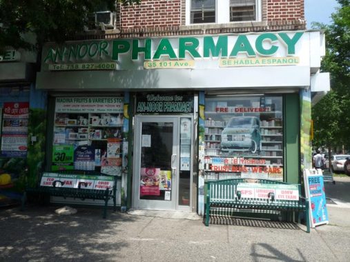
Number 35 101st Avenue, corner of Drew, is the An-Noor Pharmacy…
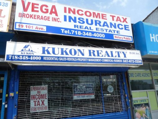
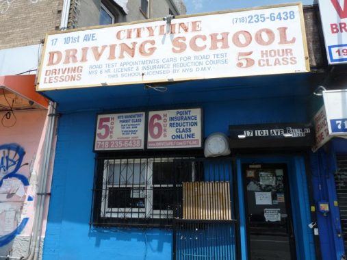
#17 and 19 101st Avenues
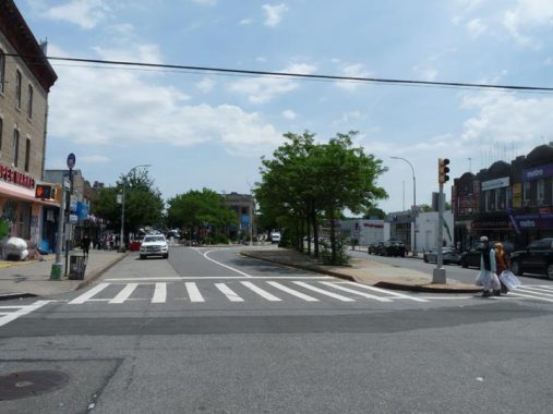
Looking east from Forbell Street where 101st Avenue (left) separates from Liberty Avenue (right)
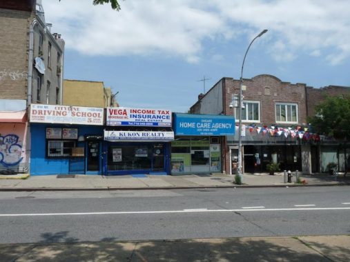
A look at most of the addresses on the block of 101st Avenue within Brooklyn.
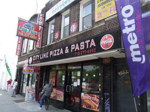
The Brooklyn neighborhood of Cypress Hills can be found just west of the Queens line, but many still call it “City Line.” For a few years in the late 19th Century, this was where the City of Brooklyn ended and where you entered the county of Queens. That name became moot in 1897, when Brooklyn residents narrowly voted to become part of Greater New York on January 1, 1898. This pizzeria gets in the old spirit.
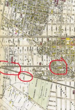
Here, I screen grabbed the borderline area of Brooklyn and Queens in 1909. I have circled the junction of Liberty Avenue and 101st Avenue, as well as the Liberty Avenue label and 101st Avenue’s name in 1909… Broadway.
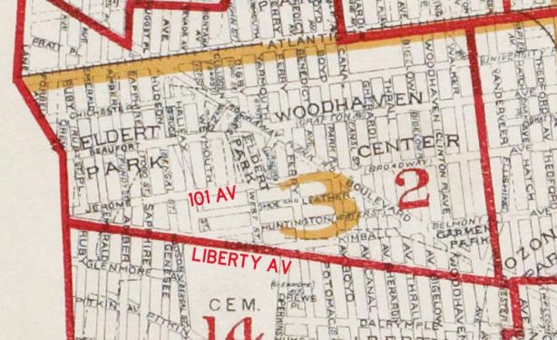
Moving forward to 1918, we can see that Broadway had been renamed Jerome Avenue, possibly to avoid confusion with Queens’ other Broadway in Astoria (in 1918, there was also a piece of it in Elmhurst, and the two pieces would be connected when the IND Subway was built in the 1930s).
Duplicate street names, as well as duplicate numbered streets in different neighborhoods, were a major impetus behind Queens getting an overall street and house numbering plan beginning in the 1920s…but that did not end the problem of duplicate numbers, as there’s an area in Maspeth where seemingly every street is numbered 60.
Thus, we can see that when the street grid was built at the Kings and Queens County border, the street numbering system we have today was not in effect, i.e. there was no 101st Avenue laid out in Brooklyn because it was named Broadway and then Jerome Avenue. It’s an accident of geography that one block of 101st Avenue wound up in Brooklyn.
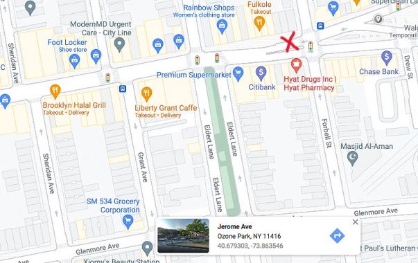
Something interesting happens when you dial up Google Maps and click on the block of 101st Avenue between Forbell and Drew. A box pops up that labels it Jerome Avenue! That means one of two things. a) The Google Maps people do research older maps or b) locals call this block Jerome Avenue instead of 101st Avenue.
If you know, Comments, as always, are open.
6/22/21
12 comments
Why do some of the houses on the west side of Drew (the Brooklyn side) use Queens numbering, while others on that side use the Brooklyn system? (Or in some cases, both…e.g. 97-22 is also marked as 440.) That must make it very confusing for mail carriers…
Some related anomalies in the same general area.
The south side of 95th Avenue (Formerly Chichester Avenue) between Eldert Lane and Drew Street is in Brooklyn; addresses use the Queens numbering system. On Drew Street the Queens numbering system is used on the Brooklyn as well as the Queens side until south of Liberty Avenue, where it is entirely in Brooklyn.
The half-block stub of 155th Avenue running west of 78th Street is physically in Brooklyn and by rights would be Cozine Avenue. DOT feels otherwise and the sign says 155th Ave. A group of houses on the west (Brooklyn) side of 78th St. off 155th Ave. are numbered using the Brooklyn system; I’m not sure whether they use 78th St. or Sapphire Street as their address. All the signs on that block say 78th St., further up there are Sapphire signs and at Linden Blvd. are both 78th and Sapphire Street signs, depending upon which corner they are on.
FNY has a piece on 95th Avenue. It’s actually in 3 separate counties.
https://forgotten-ny.com/2020/07/95th-avenue/
In all honesty, I don’t see what makes Brooklyn and Queens neighborhoods that border each other borderline crazy especially since they are both part of the same city and pay the same city taxes, but that’s just me saying this.
Years ago people in parts of Ridgewood petitioned the post office to change their zip codes to Queens numbers from the former Brooklyn ones. It wasn’t a matter of the borough’s relative prestige but simply a way of saving money. At the time, car insurance companies redlined most Brooklyn addresses, either charging high premiums or refusing to write policies at all – a practice that still exists today in some circumstances. As the companies used zip codes for these calculations, by getting Queens zip codes the Ridgewood residents could have sometimes hundreds of dollars a year on their policiies.
My family owned a business on the south side of Liberty Avenue, next door to the City Line Pizzeria. House number was 1226 Liberty Avenue. The facing stores, on the north side of 101st Avenue consisted of a drug store, a religious goods store, a shoe repair shop, and a butcher shop. Those house numbers were certainly an anomaly.
Thank you! I owned a business at 1226 Liberty Avenue between Drew and Forbell. What actually happened is only the
Portion of Jerome Avenue in Queens was renamed 101 Ave. the single block in Brooklyn is in fact still Jerome Avenue. Years ago an occasional truck driver would be lost, mixing it up with the other Brooklyn Jerome! Excellent article.
I love these deep dives into NYC maps. Hey, I’m a native New Yawka ova heeh!
Every borough should have its own color street signs. That would be really cool.
They did, from 1964-1984
I’m an attorney and brought a lawsuit for a trip & fall accident that occurred on the “Brooklyn side” of 101st. Ave. It created some initial headaches when Identifying the property, as well as venue.
A slight error on the Jerome Avenue pop up on Google. It’s showing “Ozone Park. 11416”. Google has the occasional mis-label out there.