

By SERGEY KADINSKY
Forgotten New York correspondent
THE last civilian passenger car traveled on the internal roads of Central Park on June 26, 2018, as bike activists and joggers celebrated the banishment of automobiles from the iconic greensward. Google Maps dutifully downgraded East Drive, West Drive, Terrace Drive, Center Drive, and the 102nd Street Crossing, from full-width roads to narrow lines that retained their one-way arrows.
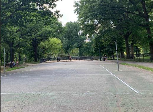
But nearly 80 years earlier there was another example of an internal road that was eliminated. The section of the park where roller skaters have their disco music and volleyball games are played has the appearance of an orphaned street that is disconnected from other roads inside the park. The Central Park Dance Skaters Association refers to this former street as “Dead road” or “Skaters Circle,” which is very much alive with music.
Center Drive is a poorly-defined road that branches off from West Drive near Seventh Avenue, but also has its start at Sixth Avenue. It then goes north to the same latitude as 65th Street, where it meets East Drive. In the original plan for the park, Center Drive continued further north to Terrace Drive on the same line as 72nd Street. On the left travelers viewed Sheep Meadow, and The Mall was on the right.
In 1938, Center Drive was reduced in length when Parks Commissioner Robert Moses redesigned the park with New Deal funding, introducing new playgrounds, reconstructing the zoo, and filling in Ladies’ Pond. It was out of character for Moses to de-map a road while seeking to expand parking at Tavern on the Green, and building highways elsewhere across the city. Center Drive was cut off from East Drive and Terrace Drive. Grass was planted at these junctions to make it appear as if the road never existed.

Looking north from the roller skating area, Center Drive ends abruptly at a patch of grass, a few feet short of Terrace Drive. While the other roads are accessible to authorized vehicles, the grassy patches at both ends of Center Drive’s de-mapped segment keeps it truly-car-free, enabling sports and music here.

More controversial among Moses’ 1930s Central Park projects was the elimination of Spur Rock, Outset, and Marble arches to make way for the expanded zoo, expansion of Heckscher Playground, and straightening a section of Center Drive. The arch was located near the junction of Center Drive, East Drive, and The Mall. Marble Arch was eliminated in order to straighten a curve in Center Drive. On this 1873 map of Central Park, I circled the site of the arch and changes to the curves on Center Drive and Terrace Drive.

Marble Arch was unique as it was the only one in the park made of marble. It served as a shelter with seating, a fountain, and a semicircular alcove on its north side. The New York Public Library has a collection of old postcards and stereoscopic views, where the cards were inserted into a device that functioned like binoculars, making two images appear as one.

Looking north into the arch, we see Center Drive on top of it and the alcove in the background. When the arch was demolished, the topography around it was raised and flattened, making it seem like it never existed. Besides old photos and sketches, the Municipal Archives has architectural plans of Marble Arch should the city ever wish to rebuild it, either here or elsewhere.

No bridge in the park is identical to the other, which made the loss of Marble Arch noteworthy. Fortunately Kevin provided a detailed story of all of the park’s extant arches in this 2001 essay.
Sergey Kadinsky is the author of Hidden Waters of New York City: A History and Guide to 101 Forgotten Lakes, Ponds, Creeks, and Streams in the Five Boroughs (2016, Countryman Press) and the webmaster of Hidden Waters Blog.
As always, “comment…as you see fit.” I earn a small payment when you click on any ad on the site.
11/4/21