

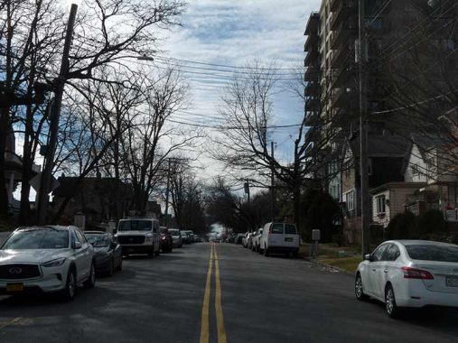
TIME for another sojourn in Staten Island, this time along the waterfront areas of St. George, Tompkinsville, Stapleton, Clifton and Rosebank along Upper New York Bay where it becomes The Narrows between Brooklyn and Staten Island. This time, though, I did not use Bay Street as is most often done, but the roads along the waterfront itself. While Brooklyn has been redeveloping some of its waterfront areas in recent years (and some over a century ago) Staten Island, as always, has had to wait its turn. While I have no doubt that every dog has its day and the impressive Manhattan views will one day be taken advantage of my residential development and parks, for now Staten Island is waiting its turn. In the 1970s, while the Navy founded a shortlived base called the Homeport, and housing is coming in by fits and starts, here Staten Island’s waterfront remains somewhat startling in magnificent desolation.
Photographed: February 12
In batch: 153 photos
Since there’s a lot of photos to get through, I’ll try to save some time by making my remarks as short and pithy as possible, except where I pick up some previously-written FNY material (you probably suspect that after 23 years I do that now and then).
GOOGLE MAP: STATEN ISLAND WATERFRONT

The only photo in Manhattan in the batch, aboard the ferry waiting to depart.


Staten Island Railway tracks run under the bus terminal overpass in St. George. These tracks were actually revived for passenger service about 20 years ago when the A-ball Staten Island Yankees arrived with the Richmond County Bank Stadium; the Yankees moved away a few years ago, but the Staten Island Ferryhawks will be using the stadium in 2022. i am not sure service may be restored to the stadium.
Until 1953, St. George served as the terminal for Staten Island Rapid Transit (as it was then called) trains going to Tottenville, South Beach and Arlington on the north shore. Today, only Tottenville service survives, but much of the North Shore infrastructure is still in place,

Speaking of infrastructure, while the remainder of the Staten Island Ferry terminal was rebuilt from 2003-2005 the bus ramps, with their iron canopies and brick walls, are pretty much the same as when they were first built in 1953.
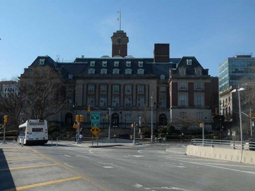
Four of NYC’s five boroughs have Borough Halls, and Staten Island’s could be my favorite. The magnificent John Carrere and Thomas Hastings French Renaissance edifice was completed in 1906. It houses the Borough President’s Office, offices of the Department of Buildings and other civic offices. On the inside, the grand marble lobby contains a series of significant WPA reliefs and murals painted in 1940 by Frederick Charles Stahr, illustrating events in Staten Island history.


Borough Place, probably named for Borough Hall, runs down a ramp and ends at a crossroad called The Promenade…

The Staten Island ferryboat Spirit of America was commissioned in 2004 and took her maiden voyage in 2006. The boat was named following the 2001 terrorist attacks and does not honor the jet propelled vehicle Craig Breedlove used to set the then-land speed record at Bonneville, Utah (400+ MPH) in 1963.

The Promenade is the main walkway on the grounds of the Staten Island Lighthouse Museum, lined with six very old buildings that played important roles in 19th Century shipping as part of the United States Lighthouse Service Depot. Four of them, in fact, are on the National Register of Historic Places, and one is a NYC Landmark. Oddly, there are no actual lighthouses to be found on the grounds of the Museum; instead, this is where lighthouse parts were built and maintained. In 2012, I took a memorable ride around NY Harbor, sailing past still existing lighthouses, one of which was destroyed later in the year by Hurricane Sandy.
The Lighthouse Depot, organized in 1852, was the base of operations for the maintenance and upkeep of lighthouses nationwide. Service employees would test and inspect new fuels and design and experiment on new tools, lenses and other implements. The 30-acre site was selected as the location for the future National Lighthouse Museum in 1998. Unfortunately, most of the buildings are still awaiting rehabilitation and are in tough shape.


A four-story brick building, known as The Barracks, dates to 1864 and is the oldest building still standing on the museum grounds. It was used by the Lighthouse Service as a depot and was converted to a Coast Guard barracks in the 1940s.

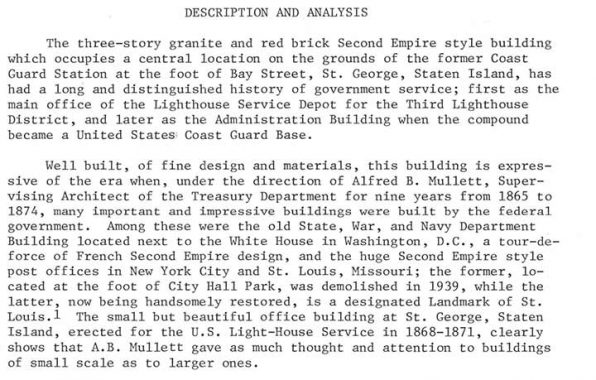
Sadly the museum building in need of the most rehabilitation is the only one recognized by the NYC Landmarks Preservation Commission. The Second French Empire Administration Building was constructed in 1869. It housed the offices of the Superintendent and Engineer of the Depot, and those of their staffs. It was enlarged to its present size in 1901. Here’s part of the LPC Report:


The 4-story Lamp Shop, built in 1868, housed the lamp and lens works. Lighthouse lenses can frequently run as large as 18 feet high and weigh hundreds of tons; therefore, the floors of this building are reinforced with steel beams and columns. A newer lamp shop, a brick building dating to 1907, is nearby.


The Dutch-roofed Machine Shop (1912) staged the construction of lightship anchors, chain and buoys. It serves as the museum visitor center and features exhibits that change periodically.


Near the Machine Shop is Staten Island’s Merchant Marine memorial, commemorating those aboard supply ships serving independently in peacetime and under the banner of the US Navy in wartime. Another Merchant Marine memorial can be found in Battery Park in Manhattan. My father served aboard a merchant marine vessel for England during WWII; he continued to serve after the war and traveled to disparate locations such as Trinidad and Greenland.


Bay Street Landing, a mix of old and new buildings, can be found along the waterfront between the Lighthouse Museum and Victory Boulevard. Finding it by auto is difficult, as motorists need to use Hannah Street and Murray Hulbert Avenue (see below). I found the waterside promenade closed — perhaps it had sustained storm damage — so I wandered into the parking lot, which let me out on Victory Boulevard. The older buildings were part of an American Dock Company complex.


Though Victory Boulevard is one of Staten Island’s longest routes, running from Tompkinsville to Travis, north of the Staten Island Railway (where you can find the Tompkinsville station) it’s reduced to a short stub. However, here you will find the Joseph H. Lyons Pool, one of eleven city pools built by Parks Commissioner Robert Moses in 1936. The pool was named for a local World War I veteran who was awarded the Croix de Guerre by France, and after the war opened Veterans of Foreign Wars Post #563. Richmond Turnpike was renamed Victory Boulevard in 1918 at his suggestion.
NYC Parks: The main pool measures 165 feet long and 100 feet wide, while both the wading and diving pools are 100 feet by 68 feet. The pool is designed to accommodate 2,800 bathers at a time; during the first summer, crowds averaged 5,707 people each day. The influence of the WPA pools extended throughout entire communities, attracting aspiring athletes and neighborhood children, and changing the way millions of New Yorkers spent their leisure time.
Moses remains a controversial figure: he eviscerated several NYC neighborhoods –and rarely wealthy ones — to build expressways and parkways. Liked or not, though, he left behind an emerald necklace of parks and twelve great public pools –built during the Great Depression. It must be noted that Moses himself, while never learning to drive, was an avid swimmer.


North of the pool Victory Boulevard ends at Murray Hulbert Avenue and the water’s edge. Here we find some woodie lampposts at an old boat landing.


The marvelously Moderne George Cromwell recreation center, with a ship repair facility alongside, named for Staten Island’s first borough president after NYC consolidation in 1898, is no more. I was surprised to see it gone during my first visit here in over a decade. The large building at Murray Hulbert and Victory Boulevard is #10 Bay Street Landing, built in 1982.
Murray Hulbert Avenue, which runs south along the waterfront, is likely named for NY Representative George Murray Hulbert (1881-1950) who become commissioner of docks and director of the port of New York City after leaving Congress. During a long illness by Mayor John F. Hylan in 1921, he served as acting mayor.


Hannah Street is bridged over the Staten Island Railway, giving a view of the Tompkinsville station, and is the only means, as far as I can tell, of getting a car into the Bay Street Landing development referred to above.
Tompkinsville is named for a small town founded in 1815 by a future Vice President, Daniel D. Tompkins, while he was the Governor of New York State. He established a ferry service to Manhattan in 1817, possibly from a landing at Victory Boulevard, and founded the Richmond Turnpike Company as an expedited means for wagons to travel to Philadelphia and elsewhere on the East Coast; the turnpike, called Arietta Street in Tompkinsville and Richmond Turnpike the rest of its length, was renamed Victory Boulevard after World War I. Tompkins was elected Vice President on the ticket with James Monroe in 1816, and served two terms. He died here in Tompkinsville just 3 months after leaving office and is buried in St. Mark’s Churchyard on 2nd Avenue and East 10th Street in Manhattan; nearby Tompkins Square Park also bears his name, as well as Tompkins Avenues in Staten Island and Bedford-Stuyvesant, Brooklyn.
Daniel Tompkins’ wife, Hannah Minthorne Tompkins, and children, are or were also remembered in Tompkinsville’s street layout. His children were named Hannah, Arietta, Sarah Ann, Griffin and Minthorne. Originally, streets in Tompkinsville bore their names; today, Van Duzer Street has replaced Sarah Ann Street, Bay Street has replaced Griffin, Sarah Ann by Van Duzer, Arietta by Victory Boulevard, but Hannah and Minthorne Streets are still in place. Hyatt Street is likely named for Tompkins’ mother, Sarah Ann Hyatt Tompkins. Daniel Van Duzer was a Tompkinsville landowner in the 1830s, with Van Duzer Street running through what used to be his holdings.
In 1836 Minthorne Tompkins (the son of Vice President Daniel Tompkins) and merchant William Staples established a ferry to Manhattan and founded the village at Bay and Water Streets. German immigrants built numerous breweries in the area in the 1800s including Bachmann, Bechtel, and Piels, whose brewery was in business on Staten Island until 1963. The region south of Tompkinsville took on the name Stapleton in William Staples’ honor.

A view of the Shining City, from Murray Hulbert Avenue and Hannah Street.


Murray Hulbert avenue continues south past the old Staten Island Navy Homeport site (the Navy base was in operation from 1990-1994 and was controversial since vessels carrying nuclear weapons were to dock there, a plan opposed by Mayor Dinkins. NYC has been weighing options on how to redevelop the old Homeport docks for over ten years. A plan a few years ago floated by Danny Aiello and others to turn it into a movie studio fell flat. Today, it runs past the Staten Island Siphon, a tunnel project transporting drinking water under the Narrows.
I find it utterly fascinating that the road runs past the waterside with no fencing whatsoever. As seen on this 1949 map, the area was lined with docks at one time; today it’s pretty desolate, and the road gives every indication of being a makeshift affair, with nonstandard lighting.


After walking along an empty stretch with nothing at all save for water views, it comes as quite a surprise to see an apartment complex, Urby, springing up seemingly out of nowhere. Though on October 26th, 2006, the New York City Council approved a massive redevelopment plan for the area that will transform it into a new community with 350 housing units, restaurants, parks, a recreation center and farmers’ market, it took until just recently for anything substantial to appear.
Ironstate has additional information:
As part of the New Stapleton Waterfront Development Plan, we are working with the City and Borough President James Oddo to transform the area into a vibrant, mixed-use community that will once again connect residents and visitors to the waterfront. Hundreds of thousands of square feet will be dedicated to residential and retail purposes, intertwined with open spaces and pathways designed to encourage pedestrian activity and public gatherings.
Urby Staten Island will feature 900 LEED-certified residential units, 35,000 square feet of ground floor retail, 600 parking spaces and a public plaza. The first phase, 571 residences, launched in February, 2016. In addition, the city of New York is investing $32 million into the public spaces to create new roads and a mile-long waterfront esplanade for the city, whose citizens will also enjoy improved public transit ridership and decreased traffic as a byproduct. Finally, from an economic perspective, the project is creating more than 1,100 construction jobs and 250 permanent jobs as we work to build a sustainable future for the borough.
Though modern developers seem allergic to using attractive exterior designs, the interiors aren’t half bad. There’s an Eggers ice cream parlor, which was shut tight on a Saturday afternoon when I went by. The area is not as isolated as it may seem as there is a Staten Island Railway stop (Stapleton) here. However, it has to be said that Stapleton itself is split into a historic region and a sketchy region, with the sketchy section centering along Bay Street, which is close by.
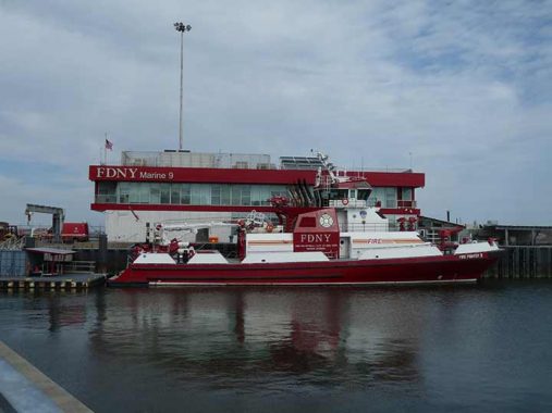
Located on a portion of the former U.S. Navy’s Homeport Pier, Company 9 supports FDNY’s new state-of-the-art fire boat, Firefighter 2, which provides rapid response capabilities for New York Harbor. The project is located within the Stapleton Waterfront, a 35-acre former Navy site undergoing major redevelopment.


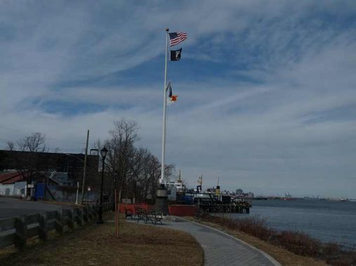
While Brooklyn boasts gleaming new waterside parks such as Brooklyn Bridge Park and Domino Park, Staten Island makes do with the smallish Stapleton Waterside Park, which opened in 2016.
Stapleton Waterfront Park was created as part of the multi-phase development of the Homeport, a 35-acre decommissioned U.S. Naval Base on the north shore of Staten Island. Designed and constructed under the NYC Economic Development Corporation, the first phase of construction broke ground in 2013 and transformed seven acres into a new, sustainable, mixed-use waterfront community. Built simultaneously with the neighboring housing and commercial development, the park includes grass and landscaped areas, benches, water fountains, a fish cleaning station, lit walkways, and a newly constructed tidal wetlands cove. Stapleton Waterfront Park was officially transferred to NYC Parks in 2016. [NYC Parks]


I don’t know the exact point at which Murray Hulbert Avenue becomes Front Street. I do know that Front Street formerly ended at Thompson Street but at some point in the recent past it was extended south to where Bay Street meets Edgewater Street. This gives motorists a much better option to get from Clifton to Tompkinsville without encountering the multitude of stoplights on Bay Street. When I was still participating in the NYC 5-Borough Bike Tour in May (before it cost over $300 per rider) the route took bikes onto Front, then Murray Hulbert, then Hannah, Bay and on to the ferry.
Here Front Street runs past the now nearly abandoned Bayley Seton Hospital, named for Richard Bayley, the head of the former Tompkinsville Quarantine Hospital (located where the Lighthouse Museum is now) and his daughter, Elizabeth Ann Seton (1774-1821), the founder of the order and the first canonized American-born saint (in 1975). Born into the Anglican Church, Elizabeth was a convert to Catholicism after the death of her husband William Seton. Her grandfather, Rev. Richard Charleton, was a rector of St. Andrew’s Church in Richmondtown and is buried in its churchyard.
After 2000 Bayley Seton Hospital fell on hard times after the Sisters of Charity turned over operations to the Vincentians, who faced financial troubles. Subsequently in 2009 the Salvation Army acquired the hospital, closing 8 of its 12 campus buildings; the eight stand abandoned and subject to predation by the elements, similar to Seaview Hospital and the Farm Colony in mid-island.
Once again, in sharp contrast to Brooklyn’s waterfront, here Staten Island’s is the province of geese and abandoned vehicles on one sort or another. I would have to believe that if additional housing joins Urby, Front Street will lose its auto repair shops and expensive housing and parkland will arrive to take advantage of the Manhattan and Brooklyn views.

In addition, Front Street also runs past the Clifton Yards, where Staten Island Railway cars are serviced and which built this relatively new facility. Today, the SIR is the only place to see refurbished R-44 cars that entered service in the 1970s.

This is where Front Street begins, or ends, at Bay and Edgewater Streets where the Staten Island Railway is bridged over near the Clifton station. I decided to take Edgewater to complete the mission, after a short stop on Bay.


Bay and Edgewater streets are connected by Camden Street, which is so short it has no addresses at all. I don’t know if its name was inspired by the New Jersey city across the river from Philadelphia where Walt Whitman spent his last days.


Alfred J. Pouch, who founded the American Dock Company in 1872, and his son, William H. Pouch, built Pouch Terminal in 1917, a pier and warehouse complex facing the Narrows on Staten Island’s north shore. Inbound freight arriving at Pouch Terminal came directly from ships or lighters at the Pouch Terminal piers, by carfloat via the Baltimore & Ohio Railroad St. George Terminal, or via the Staten Island Railway (Baltimore & Ohio Railroad) via New Jersey and the Arthur Kill vertical lift bridge. Pouch Terminal ended service in 1979. It later became an electric generating plant, and it is currently a mixed-use building called Edgewater Plaza, whose tenants have included North Shore LIJ/Staten Island University Hospital, the New York City Police Department, the city Board of Elections and Community Board 1.
William H. Pouch has a Boy Scout camp near Seaview Hospital bearing his name; I imagine he was a major $$ contributor.


Like a blackbird, I am curious about shiny things, so I inspected the colorful signage at Sofia’s Taqueria at Bay Street and Willow Avenue. I hope the tacos are as inviting as the sign.

If Edgewater Street has a defining landmark it’s this tower that belongs to a New York Power Authority electric generating plant.


Aside from Admiral Marine and the Reynolds Shipyard, which are still active, Edgewater Streets is deserted and frankly a bit spooky on the weekend.

#191 Edgewater Street is a former Wrigley gum processing plant.
In the 1860s exiled Mexican General Antonio de Santa Anna, who had defeated the Texian* rebels at the Alamo in 1836, was a houseguest of a photographer named Thomas Adams Jr. in Staten Island. Santa Anna suggested that Adams might be able to make a fortune off chicle, a gummy substance Mexicans had been extracting from sapota trees and chewing for centuries. The general believed the chicle could be combined with rubber to make better carriage tires, but that turned out not to be true. After a year, Adams was stuck with a warehouse full of chicle, bewildered about what to do with it. Then he remembered what Santa Anna had mentioned about chewing it, and became rich manufacturing chewing gum, joining forces with industrialist William Wrigley Jr.
*Before Texan became the accepted term, residents of Texas fighting for independence from Mexico called themselves Texians.
The factory was constructed in 1917 and has long been defunct, though it’s being marketed for residential housing. It would have an impressive setting by the Narrows if that ever came about.
My pal Nathan Kensinger, who ferrets out abandoned interiors, entered the old factory and got several pictures in 2008.


Another small public area along the waterfront, Matthew Buono Beach, can be found along Edgewater Street between Clifton Avenue and Hylan Boulevard. Formerly called Penny Beach, it was renamed in 1988 for a local soldier who gave his life in Vietnam. Present is a local war memorial with the names of residents who died in the wars of the 20th Century.


In early 2022, I was happy to see the Harbor House still open for customers, a bed and breakfast inn at Edgewater Street and #1 Hylan Boulevard, with terrific views (see below) from the front porch. I have fond memories of the place — I stayed here (yes, a NYC resident stayed here) while doing a marathon research session for the ForgottenBook in February 2005, and my experience was pleasant…I’d do it again if need be. (I didn’t sleep the first two nights, sleep was disrupted by a crowing rooster. I never sleep when away. My first 3 nights in San Fran in 2008 I didn’t get a wink.)
“…It’s not luxurious in any way, but it does have views over the harbor to Manhattan. The Harbor House feels more like a beach house than anything else, and you can lie in bed and look out to the water. It is distinctly un-New York in feel. Rooms tend to be large, with a clock radio, TV, dresser, armoire, ceiling fan, but there are no phones in the rooms. A good-sized continental breakfast is offered. Having your morning coffee on the porch would be a treat. It’s the water, the Verraz[z]ano, the Statue of Liberty, Manhattan, and it feels like it’s all yours.” NY Times review
This Could Be The Start of Something Big: Hylan Boulevard, looking south from Edgewater Street. After curving around Rosebank and Grasmere, from Old Town to Tottenville, Hylan Boulevard runs relatively straight down the Island’s south shore. It was built as Seaside Boulevard, but later renamed for former mayor John Hylan (1868-1936), as most of it began construction during his mayoralty. In Rosebank the former Pennsylvania Avenue was renamed Hylan Boulevard.


The water views I was talking about, available from Buono Beach, the front lawn of the Alice Austen House (see below), Van Briesen Park, and Fort Wadsworth.


Alice Austen House and Park wasn’t the end of today’s walk, but I’ll wrap up here for now.
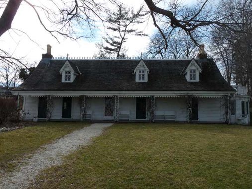
Alice Austen (1866-1952) was born to a prosperous family in what was then a part of Clifton and is now Rosebank. Her father, Edward Munn, disappeared before her birth; her mother, Alice Cornell Austen, moved with her daughter to her parents’ house, Clear Comfort, shortly after that. The house, at 2 Hylan Blvd. (then 2 Pennsylvania Avenue) had been purchased and later completely renovated from a simple farmhouse to a Victorian cottage by John Haggerty Austen, Miss Austen’s grandfather, in 1844. Miss Austen was introduced to photography by her uncle, Oswald Müller, in 1876, when she was ten. Aside from Müller’s original demonstrations, her photographic skills and techniques were entirely self-taught, she insisted.
Her subjects ranged from her family and friends on Staten Island, engaging in all manner of activities from lawn tennis, bicycling, beach outings, and costume parties (her pictures certainly belie the common image of the Victorian woman passively sipping tea indoors!). While in Manhattan, she captured images of newsboys and newsgirls, pushcart vendors, bootblacks, organ grinders, and rag pickers, subjects you would not expect a woman of privilege to entertain. Miss Austen traveled frequently, all over the east coast, Pennsylvania, Chicago, and Europe. She loved to capture the constant parade of ships that passed in clear view in the Narrows, just beyond her front lawn. (She would have loved to photograph the construction of the Verrazano-Narrows Bridge.) Her work was intimate, personal, and while curious about its subjects, never intrusive or exploitative. Some of it was frank; she was unafraid to let down her hair and be photographed smoking, quite daring public activities for women in the 1890s.
Unlike the great women photographers who followed her in the 20th Century, Berenice Abbott, Margaret Bourke-White, Diane Arbus, Miss Austen never thought about selling any of her work. She never had to, since her family was wealthy and prominent. As the decades rolled on Miss Austen and her companion, Gertrude Tate, became the sole residents at Clear Comfort and settled into a comfortable life of dinner parties and gatherings; but the 1929 stock market crash relieved her of her life savings at age 63 after she had speculated unwisely on land out west. The women subsequently operated an unsuccessful tea room and Gertrude ran a dance class for youngsters to no great profit. By 1945 the women were forced to sell their possessions and move out of the house that had been home to Miss Austen’s family for over 100 years.
The final years were an uncomfortable time, with Miss Austen living in one nursing home or another but always having to move due to inability to pay. In 1950, at age 84, she was admitted to the poorhouse…the Staten Island Farm Colony, now in ruins at the center of the island. Toward the end, however, she received some welcome recognition for her decades of photographic expertise.
When she was forced to move from Clear Comfort in 1945, Miss Austen called on an old friend, Loring McMillen of the Staten Island Historical Society, for assistance. McMillen was able to rescue some cardboard boxes in the basement containing 3,500 glass plate negatives: these comprise the collection of Miss Austen’s photographs we have today. A young writer, Oliver Jensen, published several of Miss Austen’s pictures in Life and Holiday in 1951, and the proceeds from the sale allowed her to move into a more comfortable nursing home, where she remained until her death in 1952. In October 1951 she had attended an exhibition of her life’s work at Historic Richmond Town.
In 1985 Clear Comfort was refurbished, to the way it appeared in Miss Austen’s day, as a museum. Hundreds of her pictures, of course, are on display. Currently (early 2022) the house is open only for ticketed tours from Tuesday through Friday.
As always, “comment…as you see fit.” I earn a small payment when you click on any ad on the site.
3/27/22
10 comments
Me and Dougy made a n excursion to S.I. when we were 10.The best
we could do was a small spit of beach with tarballs all over it.
Not to nitpick but one doesnt serve in the merchant marine,one simply works.
Its kind of like saying someone served with IBM or Wal Mart.People serve
in the armed forces.People just work in the MM.The MM is privately owned
shipping companies.Not Govt.
Tell that to the people who served in the Merchant Marine during World War II, risking and many losing their lives crossing the Atlantic in ships carrying precious cargo, including troops. Tell that also to the young people who enter the U.S. Merchant Marine Academy in Kingsport. N.Y., one of the five national service academies, who will graduate as officers.
Kevin: My Boy Scout troop(Troop 92/Parkchester in The Bronx) used to schedule one weekend overnight hike at Pouch every school year. You should try to see the place. As I recall it was a large old-growth forest with trails &, if I remember correctly, a lake. The reception area featured an administration building & a “trading post” (a convenience store for Scouts who forgot the Scout motto (“Always be prepared”). & therefore paid accordingly.
The only comment so far is not positive. I will tell you that those born on S.I. are always defensive. I was born there and so was my Mom. After 50 years I decided to leave but still feel connected. I think it is because we knew we were on an island. You do not get the same feeling in Manhattan never mind Brooklyn and Queens. Even the author feels that land values on S.I. are increased with a view of Manhattan.
Great job as always Kevin. The Pouch Terminal was used for one of those “Law&Order” spinoffs for a bit (can’t remember which one, but want to say Vince D’Onofrio was in it — I believe his character was banished to Staten Island for a season or two and Pouch served as the NYPD station on SI). That desolate part of Edgewater Street near Sylva Lane hosted “The Blacklist” a few seasons back during a car chase and explosion that was set in Baltimore or some other non-SI location. Funny how Staten Island is used extensively for filming, but rarely plays itself. And you’re right, Front and Edgewater streets would be filled with condos and parks if they were in any other borough, but SI usually gets short-shrift, no doubt it being the only borough without direct rail access to Manhattan, and actually the only county within 50 miles of Manhattan that doesn’t have direct rail access.
Yes Chris, you are nit picking. The Merchant Marine SERVED mightily during WW II, delivering the supplies necessary
for the armed forces to accomplish their mission. Their lives were fraught with danger. Merchant Marine ships were hunted night and day by Nazi U-Boat Wolf packs. If you would care to get some idea of what their lives were like, read Nicolas Monsarrat’s novel The Cruel Sea. While it is a
novel, it is based on fact and an accurate depiction of of what it was like to SERVE in the Merchant Marine during WW II.
In my mind, anyone who Served in the Merchant Marine during WW II is a HERO in capital letters.
Wonderful article which was shared on FB group St George Neighborhood By the Ferry and read by many
For more details on Stapleton Waterfront Park, I have an essay about it.
Thank you for sharing, as a new resident to the area about a year ago, I’m baffled by the dilapidated waterfront of the north shore. I’m blocks away from many of the sites profiled here and really enjoyed reading all the background on the various places mentioned. Hopefully Staten Island will get the resources needed to improve this waterfront.
My mom was born on a farm in Tottenville. I recently visited. My friend lives in townhouses on the water and they were lovely. South Beach has a nice pier and walkway. The island has built up significantly since the 1990’s when last I visited. I loved all the italian Pork stores and bakeries that I miss living in Pa. Hopefully Staten Island will get the resources it needs to further develop it’s waterfront.