

I was stumbling around Astoria in September 2022 when I found something interesting on 45th Street just south of 31st Avenue. I have always found Astoria and Long Island City fascinating because of the varied architecture, as the neighborhood was founded in the 1800s and before developers such as Gustave X. Mathews built block after block of multifamily houses that all looked the same (albeit pleasingly so), many different styles of buildings found homes on the same blocks. Since 2011 I have been with the board of the Greater Astoria Historical Society.
In addition, there are several road remnants to be found such as Old Ridge Road and Old Bowery Road in Ditmars (now boringly called 20th Road) and even several neighborhood remnants, such as East Astoria, that were in place before the street grid of LIC appeared in the late 1800s and early 1900s.
One such road and neighborhood remnant can be found here on 45th Street as a paved alleyway runs east to a dead end, just south of 31st Avenue. What’s unusual is that there are two small houses that face the alley, 31-11 45th Street (nearest the camera) and behind it, 31-07 45th Street. If this alley was mapped and had a name, the houses would have 45-xx addresses, since it runs east of 45th Street; instead these homes have 45th Street addresses. Was this alley once a mapped street?
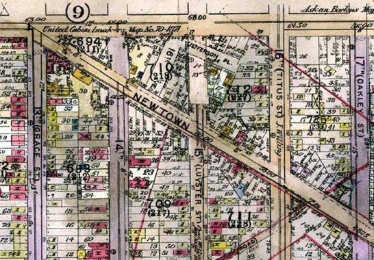
To answer this question I consulted several old maps such as this 1919 LIC atlas by E. Belcher Hyde, found in Historic Map Works, from which I got these screen shots. You can see that a dead end known as Jefferson Place runs in the same spot as today’s mysterious alley. (You can see a pair of yellow boxes, marking frame houses, on its westernmost end.) A second lost street, 16th Avenue, issues south from today’s 31st Avenue. In a confusing situation, the north-south streets they intersect on the map are also called 15th and 16th Avenues, as shown in the second map excerpt. How did that situation come about?
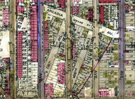
To find the answer to that question, you have to consult an older map, this 1873 atlas of Long Island City. I have circled the area in question. In this far-off era, the grid of LIC was under construction and several older streets were still in existence. The diagonal streets that are on the 1919 map are within the circled area, and you can see they predate today’s overall grid. They ran from Newtown Road, which was allowed to survive, north to Grand Avenue, today’s 30th Avenue. When the grid was built, these older diagonal streets coexisted for awhile with the new streets, and were even given the same names. Clearly, LIC government, as well as developers, fully expected the new streets to supplant the old, which is what happened.
15th and 16th Avenues, of course, were renumbered in the 1920s as 46th and 47th Streets.
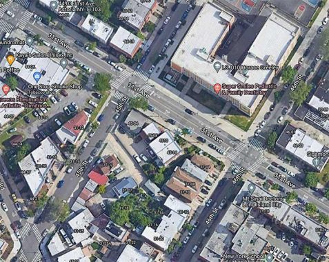
An overhead shot from Google Street View clearly shows what was once Jefferson Place south of 31st Avenue, as well as what was once known as 16th Avenue.
Related: Trains Meadow Road remnant
As always, “comment…as you see fit.” I earn a small payment when you click on any ad on the site.
Thanks to sharp eyed FNY commenters Joe Fliel and Zalman Lev for assistance with this page.
9/5/22
15 comments
When viewing the photographs of Kevin Walsh a profound sense of peace
comes over me
Lifelong area resident but this is totally new to me. You can sure find ’em.
With all due respect, Kevin, check your research. Arcadia Avenue (Grand Street) is today’s 30th Road, just south of 30th Avenue.
I believe what your alley is is actually a lost piece of old 16th Avenue. Interestingly, at least to me, there is another lost street that was named Jefferson Place that was perpendicular to this alley and appears to have dead ended just east of the alley. This remnant of 16th Avenue and the lost Jefferson Place intersected, basically, at today’s 31st Avenue and 45th Street.
This, I’m convinced, is the remnant of Jefferson Place, Jefferson Place remnant and lies east of 45th Street just south of 31st Avenjue. If you rotate the view 180 degrees you’ll get an idea where it connected to your alley because of the building with the non-perpendicular walls..
No, I am aware of 30th Road. This is south of 31st Avenue.
What I am saying is what you are calling lost Arcadia Avenue is what I am saying is lost Jefferson Place. Check 1919 Hyde Plate 6. You’ll also see what I’ve referred to as lost 16th Avenue which is the parking lot going south from 31st Avenue west of 45th Street in your Google overhead capture.
I do have one apology to make, however. I was initially confused because I was looking more closely at the map plates than your photo. If you look at your photo and the Google Street view at my link above you’ll see we’re talking about the same alley.
Grand Street ran from 13th Ave./Grace St./44th St. and dead ended just short of 17th Ave./Oakley St.,/47th St., not 18th Ave./Baldwin St./48th St.
Zalman is correct. What you identified as Arcadia Avenue is the remnant of Jefferson Place. Look at the top center of this map:
https://digitalcollections.nypl.org/items/632461fe-bbaf-97e3-e040-e00a18063f5b
Also, the parking lot, across the street to the left of Jefferson Place in the overhead Google Street View, is a remnant of that stub 16th Ave.
As Zalman mentioned above, Arcadia Ave (Grand St) is still there today to the north of the Astoria Heights Playground.
The remnants you see today are of Jefferson Place, best seen on this 1907 map (north-end between Luyster St (now 45th St) and Titus St (now 46th St)):
https://iiif-prod.nypl.org/index.php?id=1693952&t=g (Image ID is 1693952 on the NYPL digital archives for those who cannot load the link)
Also interesting is the vacant lot across the street which seems to have been a street at one point as well (16th Ave). This lot has recently sold to an LLC, and while unclear, I believe will become some sort of development.
This is an excellent resource to check Queens street name changes:
https://stevemorse.org/census/changes/QueensChanges0.htm
Thank you for the confirmation, Joe.
Your comments are correct, I was looking in the wrong spot and amended the page.
Glad to hear the record has been corrected. Thank you. And thanks to everyone who likes digging as much as I do and came up with the same conclusion.
There’s only one real Jefferson Place & it belongs to George & Louise:
https://www.bing.com/videos/search?q=the+jeffersons+theme+song&view=detail&mid=A95A073956BE39814DE9A95A073956BE39814DE9&FORM=VIRE