

I was surfing through a clutch of photographs taken in the early 20th Century by Robert Bracklow when this item caught my eye, “Plaque on the Modern Kings Bridge commemorating the original bridge on same site, New York City, undated (ca.1914-1919).” What the “modern Kings Bridge” was in 1914 is a little complicated. Currently, the location of this bridge is at Marble Hill Avenue at Marble Hill Playground south of West 230th Street, a completely landlocked location and not the site of a bridge at all. Yet in the early 20th Century, a bridge passed over a body of water in that very location.
From the ForgottenBook:
There’s a section of Manhattan sporting winding, quiet streets, country villas, and gently sloping hills a lifetime away from the traffic choked gridiron and honking horns usually characterized with Manhattan. It’s not Greenwich Village and certainly not Central Park. In fact, it’s not on the island of Manhattan at all and still, it’s in New York County, otherwise known as Manhattan.
In a little-known quirk of geography, a small piece of the borough of Manhattan, known as Marble Hill, is on the mainland. It is surrounded on three sides by the Bronx and on the south by the Harlem River. It shares its character with the neighborhoods of Kingsbridge and Kingsbridge Heights on its north and east. It is protected from Spuyten Duyvil, on the west, by a steep hill.
So why is there a piece of Manhattan on the mainland? Once it was a part of Manhattan Island and surrounded by the Harlem River and Spuyten Duyvil Creek. In 1895 it was separated from the island by the newly straightened, dredged and deepened Harlem River Ship Canal, leaving Marble Hill as an island itself. When, in about 1917, the creek was filled, Marble Hill became a part of the mainland! No one cared much until the el was built through Marble Hill and apartment buildings were constructed in the 1920s, joining the few frame houses that were already there. Marble Hill never changed its designation as part of Manhattan, and so a part of Manhattan it stays, separated from the rest of the borough by the Harlem River.
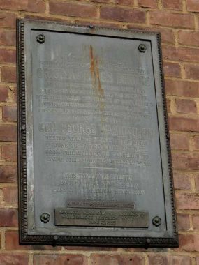
Frederick Philipse built the first Kings Bridge, a tolled span over Spuyten Duyvil Creek, in 1693. Benjamin Palmer and Jacob Dyckman built a second bridge in 1759 to avoid paying the high tolls charged by Philipse. During his retreat from the Battle of Harlem Heights in 1776, General George Washington used both the King’s Bridge and Palmer and Dyckman’s free bridge to escape to White Plains. The original Kings Bridge has inspired a network of roads in Manhattan and the Bronx, some surviving, some not, named for it. The span survived till the excavations for the Harlem Ship Canal between 1913 and 1916, though reportedly, the Bronx Historical Society maintains a small piece of it under Marble Hill Avenue between West 228th and West 230th Streets, in almost exactly its old position.
Well, Mr. Bracklow obtained a shot of this very plaque when it was mounted on the old Kings Bridge in the 1910s. Today, it is mounted on one of the buildings of Marble Hill Houses, facing Broadway, where it has been ignored by one and all except me for the last several decades. And, today I was just surfing around and found its original location! The Marble Hill Houses were built in 1952.
The plaque reads:
“Northwest of this tablet within a distance of 100 feet stood the original Kings Bridge and its successors from 1693 until 1913 when Spuyten Duyvil Creek was filled up.
“Over it marched the troops of both armies during the American Revolution and its possession controlled the land approach to New York City.
“General George Washington rested at Kings Bridge the night of June 26, 1776 while en route from Philadelphia to Cambridge to assume command of the Continental Army.
“This tablet was erected by the Empire State Society Sons of the American Revolution, June 27, 1914.”
As always, “comment…as you see fit.” I earn a small payment when you click on any ad on the site.
9/3/22
4 comments
The ironwork of the old bridge on which the plaque was mounted in the photo is of the same design as that of the University Heights Bridge (207th St) which, in turn, was originally the Harlem Ship Canal Bridge before being floated downriver to its current location. Were both the Modern Kings Bridge and the Harlem Ship Canal Bridge by the same design firm, or is the bright in the photo possibly the latter? In other words, is it possible the plaque was originally mounted on the Bronx side of the Harlem Shipp Canal Bridge?
“Benjamin Palmer and Jacob Dyckman built a second bridge in 1759 to avoid paying the high tolls charged by Philipse.”
My incessant complaints that all tolls are obscene are indeed nothing new.
I believe Washington took command of the Continental Army in
1775 not 1776. I think there might be a typo in your transcription.
The “Day and Night Bank” is mentioned in a Rex Stout novel published in 1940. I could find no mention of it online. Here’s the quotation: “‘ “The Day and Night Bank. In safekeeping for joint withdrawal only. We shake hands to pledge good faith.’” Since it was capitalized, I assume the lady speaker wasn’t referring to a generic “open all hours” business, but rather to a specific bank. The conversation took place on the streets of Manhattan at night.