
In November and December it struck me that I had never walked Bell Boulevard all the way from north to south, despite living in eastern Queens in Flushing and Little Neck for an even 30 years. Newly mobile again after hernia surgery I remedied the situation and found a couple of days around the holidays when it wasn’t raining. However, I still haven’t done the whole length. The stretch between the Cross Island Parkway and the business section at 35th Avenue is lovely but fairly unremarkable, so I did some screen shots via Street View, which explains the leaved trees there and bare trees elsewhere on this post.
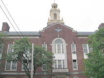
PS 31, 46th Road near 211th, with its double-ledged spire, is one of the most recognizable buildings in Bayside Hills, towering over its neighboring buildings. It is the region’s oldest public school:
Established in 1842, the original one-room schoolhouse was Bayside’s first school, located on the W.L. Titus Farm on Rocky Hill Road. In 1842 a sum of $360 was voted and raised to build the school on the Titus farm near present day 48th Avenue. This building served the community until l859. In 1864 the trustees, at the request of 16 voters, called a special meeting to vote for incorporating the school district as a Union Free School District. In 1883 the two room school building was moved to the site of present day P.S. 31. In February of 1895 the school opened its new quarters, considered one of the finest on Long Island. A contemporary description stated: “…..It has a footage of 100 ft., and makes a very imposing appearance as seen when entering the village from the east. The classrooms are 26 by 34 ft. and are well-lighted and heated…”
After the consolidation of the Borough of Queens with the City of New York, this school became known as P.S. 31. Less than fifty years later the larger building we know today was built on the old site which still serves the community today. Bayside History
Though PS31 was shrouded in construction netting, I have a couple of archived pictures. The tower has been painted gleaming white since I had been here last.
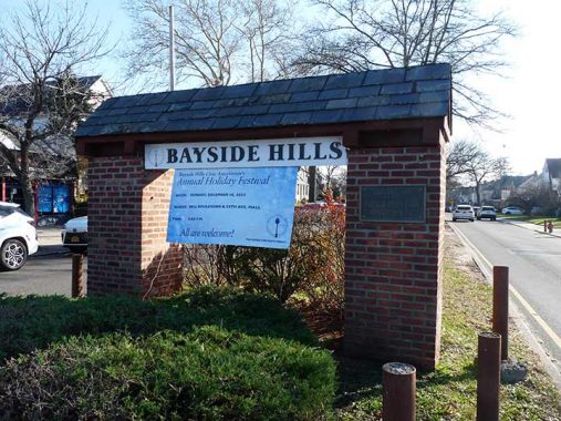
Making my way south on Bell Boulevard, at 48th Avenue I crossed the undefended border into Bayside Hills. Here, Bell Boulevard gains a grassy center median with the occasional tree and things become decidedly more residential.
Bayside Hills, actually the southern portion of Bayside, is the rectangle described by Northern Blvd., the Long Island Expressway, the Clearview Expressway, and Springfield Boulevard. It’s largely a quiet neighborhood with separate homes with wide lawns and yards, and many of the streets have center green medians. Of course, there are incursions of modern development happening, which means concrete lawns, exposed air conditioners and meters, and unimaginative construction. There are also surprising pockets of rurality remaining in Bayside Hills, and even a couple of samples of notable architecture around.
Bell Boulevard is on a gentle curve through Bayside Hills and thus has some angled intersections with other north-south streets. A local neighborhood association installed this handsome street clock at 214th Street. Unfortunately botth sides were stopped at 2:21 which was not the correct time.
My guess is that most of Bayside Hills had the same developer who laid out the streets. Not only Bell Boulevard, but 51st, 53rd, 56th and 58th Avenue all have center medians. What I can say is that Bayside Hills is relatively new and wasn’t developed until just before WWII. Before that most of it was part of the Queensboro Country Club. Many of the local homes were built by Gross-Morton Homes: George Gross, president and CEO; Al Gross, vice president in charge of sales, and Larry Morton, their brother-in-law, in charge of construction.
A second triangular plaza is found at 215th Street and 53rd Avenue, and it’s unusual at least by my standards. Thwere’s a flagpole, likely not the original, dedicated during WWII with plaques added by the Bayside Hills Civic Association for subsequent wars. There’s also an octagonal park pole with a pair of nonstandard street signs (likely installed by the BHCA) in Helvetica Bold Condensed.
The Colonial Church of Bayside makes a prominent appearance at Bell Boulevard and Luke Place (though its steeple m=needs a paint job). The congregation, associated with the Reformed Church, was founded in 1938 and this no-nonsense church building was dedicated the following year. The building is shared with a Korean congregation.
Luke Place is short…two blocks connecting Bell Boulevard at 216th Street with 56th Avenue. It’s wide and busy at times, though, and is used by the Q27 bus. It was once part of a much longer colonial-era route, Rocky Hill Road. The Luke the road was named for is a mystery and may be lost to the mists of time.
This very small parcel at Bell Boulevard and 216th Street in front of the church is called Margaret E. Battle Mall. She was a school teacher, a church organist and a member of the Bayside Hills Civic Association (BHCA).
A sampler of homes at the south end of Bayside Hills, Bell Blvd. and the Horace Harding Expressway (LIE).
South of here, Bell Boulevard enters Oakland Gardens, land of sprawling garden apartment complexes, named for what was once the Oakland Country Club. Oakland Lake, 46th Avenue near Northern Boulevard, also is named for the country club. Or is it the other way around?
Pictured above is Bell Park, located between 67th and 73rd Avenues and Bell and Springfield Boulevards.
Pictured here is Windsor Park, but a couple of photos don’t do it justice…it’s truly vast. The complex, founded in 1950 by Gross-Morton, is akin to a Queens version of Stuyvesant Town. A handful of businesses, providing the necessities including the Bell Diner, are arrayed along Bell Boulevard and 73rd Avenue.
In 1950, after 54 years in the building business, Gross-Morton took a scientific approach to Windsor Park, an 18-building development in Bayside placed to emphasize light, air, quiet and privacy. All entrances face the street, all windows open to a wide vista of lawns and trees.
Originally 89 percent of the 46-acre Windsor Park was devoted to landscaped gardens, lawns, play areas and wooded parks. Bounded by Cunningham Park to the west, 73rd Avenue to the north, Bell Boulevard to the east and a greenbelt to the south, it also featured a four-acre shopping center to serve the 5,000 residents in its 1,828 apartments.
In 1952 WindsorOaks was built east of Bell Boulevard, between 73rd and 77th avenues and Springfield Boulevard. It comprised 898 apartments on 43 acres — originally advertised with free gas, electricity and parking and a lease that tenants could get out of with 30 days notice.
Both Windsor Parks and Oaks are now co-ops. Unfortunately, neither was ever recognized by the U.S. Postal Service as distinct communities, despite their large populations.
Today the developments have matured into one of the best-kept secrets of Queens County, offering unique living where city life and country life converge. [Queens Chronicle]
I suspect that Telephone Park, a playground at 75th Avenue and Bell Boulevard, was named by Henry Stern (1935-2019), an off and on Parks Commissioner during the Koch and Giuliani administrations. I could be wrong, because of an adjoining building (see below).
Bell Boulevard was not named for the Alexander Graham Bell, who first patented the telephone, but shipping merchant Abraham Bell, who purchased about 250 acres in what is now Bayside in 1824. Bell Boulevard (at first named Bell Avenue) was once the dividing line between his two farms and was largely constructed south of 48th Avenue around WWII. Bell’s mansion on Bell Blvd. and 39th Avenue remained standing until 1971.
The reason I’m thinking Telephone Park may not be a Stern-ism is the adjoining PS 205, the Alexander Graham Bell School, which was built in 1954, long before Henry Stern was in government (he was a City Councilman before he was Parks Commissioner).
Something for the lamppost geeks, of which I am a proud member. (I’m going to get pretty wonky here, so skip this section if necessary.) At 73rd and 75th Avenue are pair of now-decommissioned fire alarm indicator lamps, installed in nonstandard ways. The cobra neck pole has the light mounted at the top of the shaft; traditionally, with a mast like this, the alarm was on a J-shaped bracket installed mid-post.
Conversely, the Donald Deskey pole at 75th Avenue has the standard indicator lamp used on octagonal-shafted poles, but the Deskey had its own design (which, admittedly, was used on about half the poles). The Deskeys had major maintanance problems, which is why new ones were only produced for 12-15 years. The masts were monuted by bolts that were easily dislodged, and the fire alarm indicators never really fit correctly. In both cases, tape was used to fasten the bracket and the alarm lamp.
In any case it’s getting rare to even see a Deskey so I thought I’d take note. OK, lamp section finished.
South of 77th Avenue Bell Boulevard passes beneath the Long Island Motor Parkway; when first built in the early 1900s, it was Long Island’s first major auto route. It was extended into Queens from 1924-1926, at which point it ran from today’s Grand Central parkway to Lake Ronkonkoma. Though the pathway in Queens is now used by bicycles and pedestrians, some of what appear to be on ramps (like the one here) can occasionally be discerned. When Robert Moses built the Grand Central and Northern State Parkways in the 1930s, the LIMP’s revenue was greatly reduced, and it was closed in 1938.
When the “LIMP” was first built in 1908 Bell Boulevard was not yet extended this far south and the presence of on-ramps is mere conjecture on my part. However, I find it curious that NYC Parks hasn’t built a ramp and/or staircase to allow pedestrians access from Bell Boulevard. Pedestrian access currently is facilitated by walking east on 77th or Kingsbury Avenue, which parallel it, to entrances at 220th Street.
Hollis Hills
South of the “LIMP” Bell Boulevard enters its southernmost section, Hollis Hills. According to the New York Times, the name “Hollis” comes via Frederick W. Dunton, the first developer of the area, which was once known as East Jamaica. He was a native of Hollis, New Hampshire. Originally, Hollis, a parallelogram defined by 180th Street, Francis Lewis Boulevard, Hillside Avenue and 104th Avenue and bisected by Jamaica Avenue, was settled by the Dutch and centered around the present intersection of Jamaica Avenue and Hollis Avenue, which was once called Old Country Road. Dunton developed several neighborhoods surrounding Hollis, many of which carry “Hollis” in their names, including hilly, exclusive Holliswood, now south of the Grand Central Parkway, and more middle-class Hollis Hills, to the GCP’s north.
South of the parkway, Bell Boulevard meets Peck Avenue, one of Queens’ most interrupted non-numbered streets. It runs in pieces from the Queens Botanical Garden in Flushing to Hollis Hills along the south side of Kissena Corridor Park for most of its length (which itself is the former route of A.T. Stewart’s Central Railroad of Long Island, which ran from Flushing to Garden City from 1871-1881, after which it was purchased by the Long Island Rail Road, which closed most of its sections).
Peck Avenue is named in honor of longtime Flushing resident and property owner Isaac Peck (1824-1894). In 1847 Peck settled in Flushing. Owning most of the property, Isaac Peck built a three-story department store along Clinton Street (now part of College Point Boulevard). The second floor of the structure held a terrace upon which patrons waited for the steamer Flushing. The ship carried passengers from the communities of Jamaica, Whitestone, and Bayside into Manhattan (reachable at the time only by boat). [NYC Parks]
Isaac Peck is buried in the St. George Churchyard on Main Street in Flushing. Peck’s Stationery was a Main Street fixture for decades and Peck’s still runs an office furniture store in Brooklyn; it’s a good bet those Pwecks and Isaac are related.
The Invaders, alien beings from a dying planet. Their destination: the Earth. Their purpose: to make it their world. David Vincent has seen them. For him, it began one lost night on a lonely country road, looking for a shortcut that he never found. It began with a closed deserted diner, and a man too long without sleep to continue his journey. It began with the landing of a craft from another galaxy. Now David Vincent knows that the Invaders are here, and that they have taken human form. Somehow he must convince a disbelieving world that the nightmare has already begun.
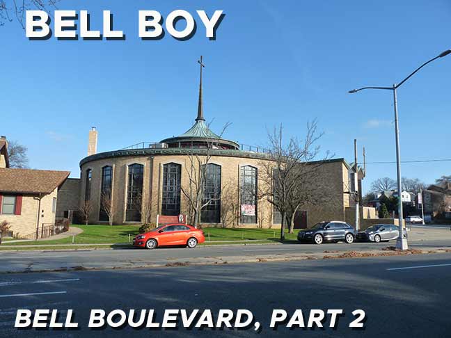
The saucer has landed at Union Turnpike and Bell Boulevard, where you find the American Martyrs Roman Catholic Church, built in 1967. The martyrs were eight Jesuit missionaries to the Huron Indians in the 17th Century. All eight were killed during a Huron conflict with the Iroquois in what is now Quebec and upstate NY between 1642-1649.
I find this building so fascinating I wanted to get it from multiple angles.

Across from the church on Bell Boulevard is the Windsor Park branch of the Queens Library. I like the stonework on the exterior and the use of Future in the sign. I’ve been in here…sort of. This is the place where, in November 2020, I got my first Covid test, Q tips up the nostril. This is before home tests became commonplace.
I think I have gotten more shots in the past two years than in the previous 20. I am scheduled for another soon…second shingles shot. Say that 10 times quickly.
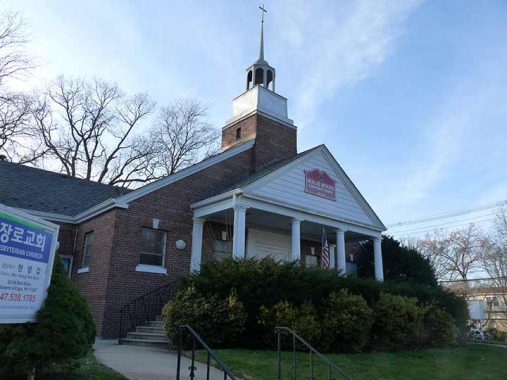
South of Union Turnpike is another of Bell Boulevar’s distinctive “newer” churches, Hollis Woods Community Church, which also houses a Korean congregation, Sammul Presbyterian.
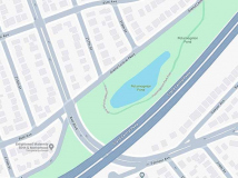
I wanted to inspect an old friend, Potamogeton Pond, a kettle pond just east of Bell Boulevard at Grand Central Parkway. Unfortunately it appeared to be totally dried up. I did get a few photos inside the park, but I seem to have misplaced them. The pond, when it’s full, is named for a common water plant. I had thought that it was Lenape or Native American in origin but it’s actually Greek. This FNY page from 2011 shows the pond when there’s actually water in it. Parks has fixed the spelling, as older signs got this easy to misspell word wrong. Perhaps January’ 2024’s twin heavy rainstorms have helped things somewhat.
FNY compatriot Sergey Kadinsky has much more over at Hidden Waters.
How’s your pagoda? The New York Buddhist Vihara temple makes a final impressive Bell Boulevard act south of Grand Central Parkway. The temple, established in 1980, found a permanent home at the south end of Bell Boulevard in 2000.
Bell Boulevard’s traffic flows onto and out of (why isn’t “outof” a word?) modest Spencer Avenue, which actually predated Bell Boulevard and was widened when the connection was made some decades ago. A short spur dead ends west of Bell Boulevard, and the Buddhist temple actually has a Spencer Avenue address. Bell Boulevard’s traffic flows south onto 217th Street and Springfield Boulevard, where Braddock Avenue takes traffic into Queens Village.
As always, “comment…as you see fit.” I earn a small payment when you click on any ad on the site. Take a look at the new JOBS link in the red toolbar at the top of the page on the desktop version, as I also get a small payment when you view a job via that link.
1/14/24

12 comments
I remember when the story of the American Martyrs was read aloud in 4th grade.
Sister Regina Sewell looked mighty grim when we came to the part where their heads
got chopped off.
Hey Kev – I’ve ridden to Potomogoten Pond several times over the years. Most of the times it is either dry or swampy. BUT, when Ive been there in spring after a heavy rain – I have seen it as an actual small pond.
The Long Island Motor Parkway’s terminus was not at the Grand Central Parkway, but at current Horace Harding Boulevard (LIE South Service Road). That is just behind the current St. Francis Prep (formerly my alma mater, Bishop Reilly High School).
I believe that Peck was a director of the Central Railroad of Long Island, which is how his name became attached to the road that ran on one side of the railroad right-of-way. The name of the road on the other side of the right-of-way is Underhill. I believe that he, too, was a director of the Central Railroad of Long Island.
On the southeast corner of Bell and 48th was a great restaurant/bar called Blossoms and under the current FoodTown was Jimmy’s Comedy Alley where I saw many wonderful performers including Robert Klein, Sam Kinnison, Colin Quinn, Louie Anderson and others.
I am surprised you didn’t mention anything from Northern Blvd south th 48th Avenue. There are stores there at the intersection of Bell Blvd and 48th Avenue. That is the neighborhood I group in and all of us attended P.S. 31.
What a cornucopia of fond memories this is for me. Where to begin? First, there’s the Colonial Church of Bayside. My family & I were members from 1994 – 2001. We had left our previous church of the same denomination for two reasons: one was that we had moved from Queensborough Hill to the Alley Pond Co-op in 1991. We had to change churches three years later because there was endless turmoil in that church which caused the young pastor there to resign in disgust. However, the Colonial Church, though it had a larger congregation, had a similar turmoil causing a young rogue pastor to move on at the “suggestion” of the consistory. He was replaced by another young man who became very popular with the congregation. For some reason the consistory took exception to this & two Sundays before 9/11 he tearfully announced his resignation. The congregation nearly rioted, calling for the resignation of the consistory (but they didn’t); we merely left in disgust & on the Sunday after 9/11 we joined Church On The Hill in Flushing; to this day we consider it to be the best church ever.
Moving right along: the LI Motor Parkway Bridge was just around the corner from the Alley Pond Co-op where we spent nine great years (1991-2000). Windsor Park Co-op has its own swim club & tennis courts. Many of the residents wouldn’t pay the annual membership so the board accepted non-residents as members, charging them a higher amount. We gladly joined. It was worth it & we spent our summers there until our 2005 departure to AZ. My daughter was a “mercenary swimmer” for American Martyrs; the coach was very happy to have her on the team. A few years later she made the Martin van Buren HS swim team & in her final year, the team made it to the citywide finals at Lehman College where she would place third city-wide in her event (third place might sound like a loss but in a city of 8 million it’s significant, at least to me).
I’ve said it before & I’ll say it again: if circumstances force you to remain in NYC, Bayside offers a good quality of life (probably much better than elsewhere in NYC). However, I like retirement in AZ even more. As Bob Hope sang: “Thanks for the memories”
Growing up on 217th Street between 82nd and 85th Avenues in the 1960s-70s, I recall the frogs that found their way from the pond.
I’m surprised that Bell’s mansion wasn’t preserved despite being known for the telephone.
Did you read the piece? Bell Blvd has nothing to do with Alexander Graham Bell.
That mansion could have still been saved.
Coulda, woulda, shoulda…
And all the while St. Saviour’s still sits in storge trailers waiting for a savior.
What replaced the mansion after it was torn down?