

HEY, I just had to get out of the house, and Saturday, January 27, 2024 was the only day to do it. I work from home all week and my time is carefully monitored with online checkins, synopses, etc and at most, I can walk a few blocks around FNY HQ in Little Neck between 1 and 2 PM. At least until March, it’s dark after work, so I can’t get a lot of usable photos then either. Thus, I set out on what turned out to be a very dark albeit rainless day (there was a patch of blue over Little Neck in the morning that I knew wouldn’t have staying power).
Today I walked in Middle Village and Glendale, two areas I haven’t been in since 2019-2020. Middle Village is so named because it is directly between Williamsburg and Jamaica as one travels on Metropolitan Avenue, which was laid out around 1815 to connect the two towns. The eastern end of Fresh Ponds, where Forest Park is today, was called “Dry Harbor” because it was said that houses there appeared to be sitting atop the crests of trees and hills, resembling a harbor without water. Today’s 80th Street was originally an extension of Dry Harbor Road, named after this part of the community. In the early 1860’s, developer George S. Schott acquired a considerable amount of land in Fresh Ponds as repayment of a debt owed him. As the Civil War drew to a close, he founded what is today known as Glendale, which he named after his hometown of Glendale, Ohio. At this time, the area’s main occupation was farming. In the late 1800’s, picnic grounds and beer gardens flourished due to an influx of German immigrants into the area.
GOOGLE MAP: ALL FAITHS-GLENDALE
On this map the walking portion was Metropolitan Avenue to Queens Boulevard; after that I got the F to Roosevelt/74th but was forced to then get a #7 east to Mets/Willets Point, then hoofed it down to the LIRR Mets/Willets Point station in Flushing Meadows (which now thankfully is open all year) and caught a LIRR home after a 20 minute wait.
Bury Me in Glendale?


East of 80th Street, Cooper Avenue skirts the south end of St. John Cemetery (officially, it’s St. John, without the apostrophe s.). From the cemetery’s website:
To serve the ever-growing needs of families in Queens and Brooklyn, Bishop John Loughlin, the first Bishop of Brooklyn, purchased the Mills farm located in Middle Village in 1879. The cemetery was consecrated on November 27, 1881…In 1933, the acreage on the southern side of Metropolitan Avenue was developed and made available for interments and, finally in 1947, the last parcel was procured and developed, bringing St. John Cemetery to the one hundred and ninety acres currently maintained and cared for. [St. John Cemetery]
Famous interments include bodybuilder Charles Atlas (Atlas Park, see below, is across the street); journalist Jimmy Breslin; mobsters Joe Colombo, Carmine Galante, Carlo Gambino, Vito Genovese, Lucky Luciano, Joe Profaci and John Gotti; NYS Governor Mario Cuomo; NYC Mayor John Hylan; art photographer Robert Mapplethorpe; actor Philip McKeon; and the Yankees’ Joe Pepitone.
And, just maybe, me. My parents and grandmother are in St. Joseph’s Cemetery in Troy, NY, which would be my preference, but the plot, I’m told, is full (I still do want to purchase a stone for it.) My uncle Jim’s family has a plot in St. John, while Jim himself, a WWII veteran, is in Calverton in Suffolk County. I have yet to sign any necessary paperwork and want to get a stone for myself. As the Boy Scouts say, “be prepared.”
Atlas Park
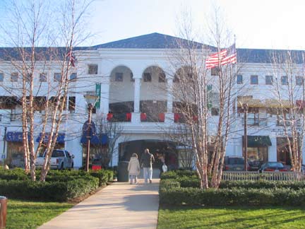


This was my third all-time visit to The Shops at Atlas Park, an open-air shopping mall located south of Cooper Avenue between 80th and 82nd Streets. Unlike most “shopping malls” around town that are shops arranged along a parking lot, Atlas Park has an actual mall, albeit one with artificial grass. The mall is anchored by Forever 21 (formerly Century) , Foot Locker and other retail, and has restaurants such as California Pizza Kitchen (which is where we ate before a meeting of the Newtown Historical Society a few years ago). I also visited when a bookshop (I forget which) was located there. I liked the white neo-Classical buildings, but was more fascinated by the leftover brick buildings from when this was Atlas Terminal, a freight exchange on the Long Island Rail Road (see below). That building now hosts Home Goods, which is essential when you’re in need of large ceramic roosters.


(Note: the photos in the above Gallery are smaller than the sizes I save photos currently; they date to the early 2000s)
Construction of the industrial park Atlas Terminal commenced in 1904. In 1922, the Hemmerdinger Real Estate Corporation purchased the site and over the years expanded the terminal to 16 buildings. By the end of WWII, it had become Glendale’s largest employer. A few of the tenants throughout the years were: Kraft, General Electric, Westinghouse and New York Telephone. In 2003, the terminal was decommissioned for railroad use. Most of the buildings were torn down in 2004, with the mall constructed thereafter. The ever-reliable Trainweb has old photos and maps of the terminal. The GE locomotive displayed for years on the property was moved to the Shoreline Trolley Museum in East Haven, CT.
The industrial park’s water tower remains as a reminder of the mall’s former purpose.


We have two TV shows from two different eras on today’s tour. I recently heard the Beatles cover band Yesterday and Today at Yerman’s (as in “Yer Man”) Irish Pub on 88th Street south of Cooper. Its former incarnation as Cooper’s is still evident in a stained glass panel. The tavern was featured in the TV sitcom King of Queens with comic Kevin James as a harried UPS driver and Jerry Stiller as his father.


And Aubrey was its name. A grouping of three streets between 88th Street and Woodhaven Blvd. south of Cooper have curiously retained their old names instead of numbers, Aubrey, Doran and Rutledge. The Department of Transportation has supplied them with retro Type F lampposts, an interesting choice.
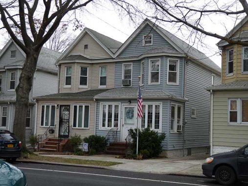
The house on the right, one of a number of attached houses on the south side of Cooper facing the cemetery, #89-70, stood in for the exterior of 704 Hauser Street, Archie Bunker’s house in Astoria, in the opening sequence of on the TV show All In the Family, whose frank humor devised by the recently deceased (as of 2024) Norman Lear could never be attempted today on network television. The flagpole was already in place in 1971 when the show debuted.

Cooper Avenue ends at Woodhaven Boulevard, but Yellowstone Boulevard, a direct route into Forest Hills, picks up where Cooper leaves off. We have already seen or mentioned two freight railroads, the NY Connecting RR and the LIRR Montauk Branch in Part One, and here’s a third, the defunct LIRR Rockaway Branch. Unlike other nonused RR rights of way such as Alexander Stewart’s Central RR of Long Island in Flushing or the old Culver Shuttle, it hasn’t disappeared nearly without trace and its old path is easily traced. In 2000 I walked its route and I have given a Forgotten NY tour following its remains. Here, a rusty Rockaway trestle is bridged over Yellowstone.


The Compost Collective, underneath the railroad bridge at Yellowstone, is not yet open for the season but the gate was open for volunteer preparation work. I know next to nothing about composting, so I’ll let them explain what they do.
At The Compost Collective we work with our local communities to collect food scraps and yard waste, diverting them from landfills and re-purposing them into compost. Our compost is used to remediate the soil, which helps reduce leachate and green house gases from our atmosphere, and creates healthy soil and land resilience. We share the understanding that soil is a vital, living life source that must be protected for future generations. [Compost Collective]

Directly across Yellowstone Blvd. from the Compost Collective is the Project Eden community garden on Kessel Street:
The landscaped enclave, which was founded in 1992 after being acquired by the Parks Department, is the result of a partnership of local volunteers who set an example for their community and the planet.
What was once a trash-infested lot filled with tar deposits and boulders alongside the old LIRR Rockaway Beach Branch Line, is now home to diverse plants, vegetables and herbs.
It is an attraction for wildlife, community events, and a place to sit and unwind. It has indeed become Forest Hills’ own “Garden of Eden.” [Mike Pearlman, Forest Hills-Rego Park Times]
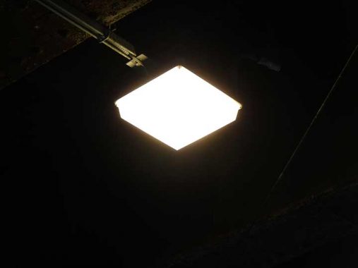
I noted that the road underneath the RR bridge is illuminated by new LED lamps with diffuser covers. One of my main complaints about LED lamps has been that the light is harsh without diffuser bowls or covers, but apparently it can be done.


Hopefully that compost smell doesn’t waft north along Yellowstone Boulevard, whose southern stretch is dominated by Tudor-style attached houses with neat front yards, the dominant residential style in Glendale and southern Forest Hills.
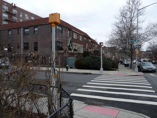
I noticed something about the pedestrian control (former WALK/DONT WALK signals) at Groton Street and Yellowstone. They’re top-mounted on their usual cylindrical poles instead of side-mounted in pairs, one each controlling Groton and Yellowstone crossers. Clearly there’s room to side-mount each on the corner lamppost. I wonder why the DOT did it like this.
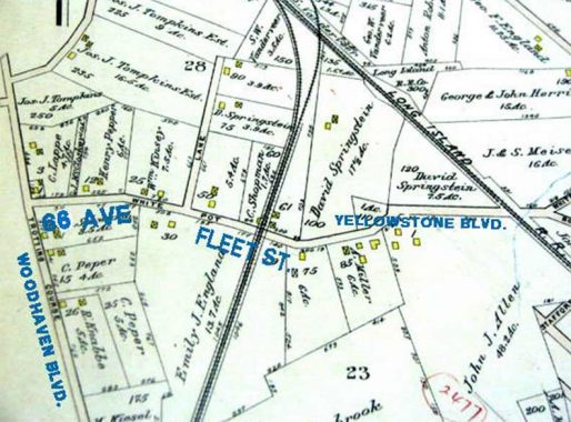


If you look at a Forest Hills map, Dane Place is a one-block street running between Fleet and Exeter Street where it meets Yellowstone Boulevard. Same attached houses as on Yellowstone, too. But it’s got history.
The Hempstead Swamp once occupied a vast area of land that sits just east of present-day St. John Cemetery in Queens. The greater area was first settled in 1653 as ‘Whitepot’ by English and Dutch farmers, including the Remsen, Furman, Springsteen and Morrell families. They found the land good for growing hay, straw, rye, corn, oats and various vegetables. During colonial times, there were only a few roads that cut through the marsh. One of these was Whitepot Road, which followed a course that is still there but is now 66th Avenue, Dane Place and part of Yellowstone Boulevard.
The village of Whitepot was part of the Township of Newtown. A legend says that it was called Whitepot because it was purchased from the Indians for the cost of three white pots, but its actual original Dutch name was ‘Whiteput,’ which means “hollow creek.” When the English took it over, the name was Anglicized.


The dogs were starting to bark and I wanted to get to the Queens Boulevard line to get me back to the LIRR at Woodside, but as we’ll see, I had some more walking to do. I inspected the 67th Avenue pedestrian bridge over the LIRR main line…
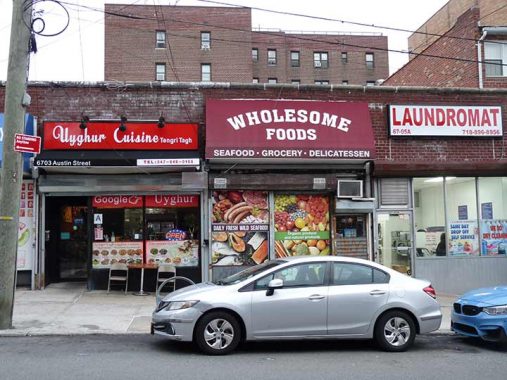
…and spotted the first Uyghur restaurant I have seen in Queens, on Austin Street. Uyghurs (pronounced WEE-gurs) are a West Asian people, mostly Muslim, allied ethnically with the Turks as well as Asians who live mainly in southwest China; many Uyghur advocates maintain that the Chinese have forced them into internment camps and are trying to wipe out this ethnic minority. (Geopolitics is not in FNY’s pay grade.) Uyghur cuisine is is “characterized by ingredients like roasted mutton and beef, as well as kebab and rice dishes. Traditionally, specific dishes like polo are eaten with one’s bare hands instead of with utensils like spoons, forks or chopsticks. Signature dishes include polo, läghmän, and nan. Because the majority of Uyghur people are Muslim, the food is predominantly halal.”
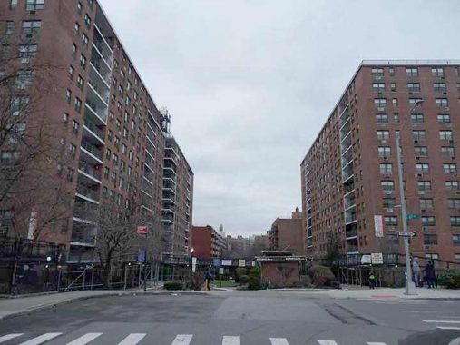
This large apartment complex at 67th Avenue and Austin Street consists of a pair of buildings, the Brussels and the Marseilles. Perhaps the developer was European.


Jumped on the F at 67th Avenue, debarked at Roosevelt/74th to catch the #7 two stops to Woodside. But there was a problem. An elevator replacement at Queensboro Plaza stopped #7 and N service there, with the R filling in for the N. All #7s were reversing at 74th and heading back east.
Since I know how to get around, I adjusted and took the #7 to Willets Point and walked the Passerelle Boardwalk over the #7 Corona Yards and the Casey Stengel bus depot (named for the Mets’ first manager in 1962)…


…to the ramshackle Mets-Willets Point LIRR station in Flushing Meadows Corona Park. The MTA, since the pandemic, has vouchsafed to open it year round, instead of just for Mets games, concerts and US Open tennis. Unfortunately it is still bare-bones and has no escalator or elevator for mobility-challenged Mets fans who may wish to use it. The station was set for a renovation that would include an elevator, but that was hinged on ex-NYS Governor Andrew Cuomo’s boondoggle of a plan to build an AirTrain station here to take passengers to LaGuardia. That plan was considered unworkable by Cuomo’s successor Kathy Hochul, but that meant Mets-Willets Point is still rudimentary and will remain that way for awhile yet.
As always, “comment…as you see fit.” I earn a small payment when you click on any ad on the site. Take a look at the new JOBS link in the red toolbar at the top of the page on the desktop version, as I also get a small payment when you view a job via that link.
2/4/24
4 comments
Great article as usual. BTW the Brussels and Marseille houses were built by LeFrak. They still manage them.
Great article about areas I’m very familiar with. I recall peering through the gates at Alas Park back in its industrial days. There were trains running through the yard and men busy with various tasks. It felt like they were doing secret work and I so desperately wanted to be part of it. Many years laterwhen it became a mall, the young girl in me mourned the lost possibility of being part of that secret society.
So many houses in Queens are built side by side like that.
“So what’s the story?”
There are attached houses, and detached houses. The word for Archie Bunker’s was semidetached! Do people still use these terms?