

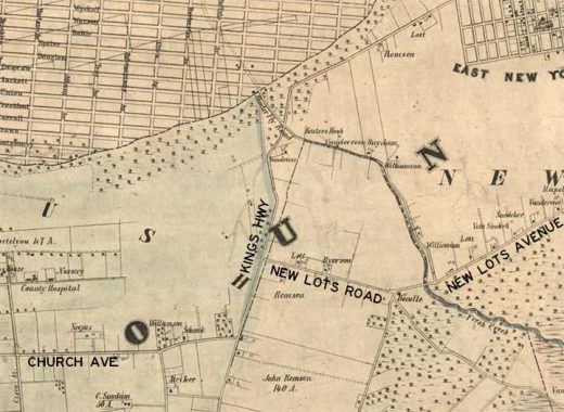
TIME once again to look at some ancient maps depicting the New York City of long ago. Here’s a map excerpt of the area where East Flatbush, Brownsville and East New York come together, from a 1922 Hagstrom map, one of the first editions of a company founded in 1916. Overall, the street pattern remains the same as today, though in 1922 much of this area was simply a hope and a prayer of real estate developers. Much of it was built. But the map shows a couple of roads that would baffle anyone looking for them today.
Oddly, Kings Highway is depicted as a narrow lane, not the 8-lane behemoth it is today. In 1922, Kings Highway was still a narrow lane bisecting farms. It’s part of a colonial-era road known previously as The Road From Flatlands and Canarsie, or alternately as Flatlands Neck Road. (The colonial-era Kings Highway turned northwest and assumed Flatbush Avenue’s path all the way to Fulton Ferry.).
At Lenox Road and East 94th Street, it intersected New Lots Road, part of which was preserved in 1922 as a trolley right of way. This was the western end of what is now the surviving portion of the road, now called New Lots Avenue. The town of New Lots was originally part of Flatbush and was founded by agriculturalists seeking fresh pastures who settled out east. New Lots became the 6th town of Kings County before all the towns were absorbed by the city of Brooklyn, which was then annexed by New York City in 1898.
Let’s go back 70 years earlier, to a Dripps map depicting the area in 1852. You can see that Kings Highway and New Lots Road were in place then; they may well have been Native American trails, and before that, animal traces through the woods. At lower left you can see the road that became Church Avenue. Interestingly Kings County Hospital was already in place then, serving area farmers and field hands. Church Avenue still takes the slight bend shown on the map.
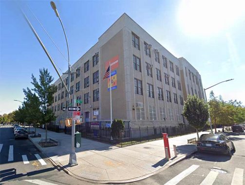
Today, the spot where New Lots Road emanated from Lenox Road and Kings Highway at East 94th Street is marked by Intermediate School 252 (or Junior High, as they used to call it). Does any trace at all exist of the old portion of New Lots Road?
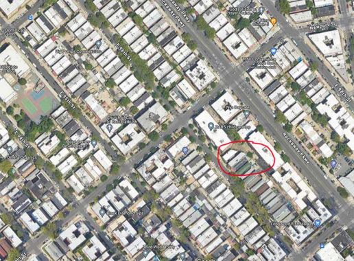
Well, I wouldn’t have brought it up if there didn’t. I have circled in red a building facing East 96th Street south of Willmohr. Note the slanted rear end of the building. When it was built, it had to conform to the property line, which still ran along the vanished New Lots Road.
Who says ghosts don’t exist?
As always, “comment…as you see fit.” I earn a small payment when you click on any ad on the site. Take a look at the new JOBS link in the red toolbar at the top of the page on the desktop version, as I also get a small payment when you view a job via that link.
5/1/24
9 comments
Look how long Hunterfly Road travels. Also, “Freak Creak.” WTF is “Freak Creak”
Fresh Creek
Always fascinating stuff. Thanks for your research.
If (on Google Earth) you go over to the corner of Rockaway Pkwy. and Church Ave., The Rogosin Institute building has a notch in the roof that looks like it could line up with the two residential buildings on E. 96th…
I was driving my son to baseball practice at the American Legion field in Canarsie, when I drove past Matthews Pl. It looked like an alley, but the street sign caught my attention. Any info on this alley/street?
The current route of Linden Boulevard, today a multi-lane speedway, is missing from this map because it was not built till probably the 1930s (not 100% sure). Linden Ave. on this map between Lenox Road and Church Ave., is now named Willmohr Street. The current Linden Blvd. runs eastward from today’s three-way intersection with Remsen Ave. and Kings Highway, and dips southward right below Hegeman Avenue, then continues its swath through East New York to the Queens boundary.
cf.
https://forgotten-ny.com/2020/05/linden-boulevard/
Thank you, Kevin, for posting the link. I remember that FNY posting.
A note on Willmohr Street, “Will Mohr”: Originally it was the part of Linden Avenue between Remsen Avenue and East 98th Street. Changed to Newport Street at some point circa 1903, although I see that Hagstrom still has it as Linden in 1922. Renamed by the City Council June 6, 1938, in memory of Pvt. William Mohr, killed in action during World War I.