

BEFORE Brooklyn was a borough, it was a city; before that, it was a smaller city; before that, it was a small town; before that, a few huts by the East River. After the Dutch arrived at the west end of Long Island in the 1620s, they quickly settled the area and gradually pushed out the Lenape tribes that occupied it, occasionally by force. Small settlements sprang up over time, some of which have lent their name to Brooklyn neighborhoods that exist today:
Gravesend: in 1645, settled under Dutch patent by English followers of Anabaptist Deborah Moody, named for ‘s-Gravenzande, Netherlands, or Gravesend, England (the origin of the name remains disputed)
Brooklyn Heights: chartered as Breuckelen in 1646, after the town now spelled Breukelen, Netherlands. Breuckelen was along Fulton Street (now Fulton Mall) between Hoyt Street and Smith Street (according to H. Stiles and P. Ross). Brooklyn Heights, or Clover Hill, is where the village of Brooklyn was founded in 1816;
Flatlands: chartered as Nieuw Amersfoort in 1647;
Flatbush: chartered as Midwout in 1652; a large area west of Flatbush is known as Midwood.
Nieuw (New) Utrecht in 1652, named after the city of Utrecht, Netherlands; the name survives in place names like New Utrecht Avenue
Bushwick: chartered as Boswijck in 1661.
The borderlines of these towns were very irregular, and I don’t have enough time to hunt down how they were surveyed and laid out as they were. This zoomable map of Kings County in 1868 shows you a color coded representation of Kings County’s town system. The county itself was founded in 1683 as one of the twelve original counties of New York State (Nassau wasn’t one of them; it was founded in 1899 when the three eastern town of Queens seceded rather than join NYC, among other disputes).
Over time, boundaries changed and new towns were formed. The City of Brooklyn was founded in 1834, the village of Williamsburg was chartered in 1840 and became a city in 1851; then, the eastern section of Flatbush broke away to form the town of New Lots in 1852. The city of Brooklyn annexed the city of Williamsburg and town of Bushwick in 1854. Years later, the dominoes really began to fall when New Lots joined the city of Brooklyn in 1886, New Utrecht, Gravesend and Flatbush in 1894 and Flatlands, the last holdout, in 1896. Brooklyn City and Kings County were coterminous only for two years, as Brooklyn joined Greater New York on January 1, 1898.
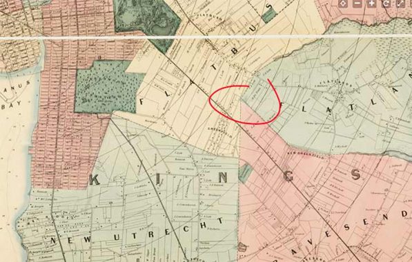
One aspect of Kings County’s towns system hasn’t been remarked upon anywhere until now. If you look at the map carefully, there is a spot where three towns, Flatbush, Gravesend and Flatlands, come together at one single point. I have always been fascinated with these junctions; for example, New York, New Jersey and Pennsylvania come together at the I-84 bridge crossing the Delaware River, and out west the Four Corners Monument marks where 4 states, Colorado, Utah, Arizona and New Mexico meet.
The spot in KIngs County where three towns met is the present intersection of Foster Avenue (explored on this page) and East 17th Street at the Rusty Nail saloon (in 2023), a block east of Newkirk Plaza on the Brighton Line (Q train), shown in the title photo above.
I definitely think the Brooklyn Historical Society should place a marker at this site, at Kings County’s original “town meeting.”
As always, “comment…as you see fit.” I earn a small payment when you click on any ad on the site. Take a look at the new JOBS link in the red toolbar at the top of the page on the desktop version, as I also get a small payment when you view a job via that link.
5/21/24
6 comments
Canada also has a four corners, where Manitoba, Saskatchewan, the Northwest Territories and Nunavut meet.
There is only one point in the world where four countries meet: near Victoria Falls, with Namibia, Zimbabwe, Botswana and Zambia.
And don’t forget that in the southwestern US, there is a “4 corners” area where Arizona, New Mexico, Colorado, & Utah come together:
https://www.visitarizona.com/places/parks-monuments/four-corners-monument/
Like it says in my post
I’ve been to Four Corners in New Mexico. A waste of a day, other than to be in that spot. Pathetic looking Indians trying to sell trinkets. No other sights worth seeing nearby.
Not to mention that the monument is about 1,800 feet from the actual surveyed Four Corners, although most people accept it as accurate enough.
From Black Mesa in far western Oklahoma you can see five states at once (Oklahoma, Texas, Kansas, Colorado, New Mexico).
There are spots all over Europe where 3 country borders intersect. Netherlands-Belgium-Germany, Belgium-Germany-Luxembourg, Luxembourg-France-Belgium, etc. Hardly a reason for a day trip, but they are well marked, and if we happened to be nearby, we’d stop for pictures of our kids holding hands while standing in 3 different countries.