

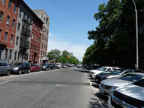
In May 2023, I walked Humboldt Street’s near-entire length, from Flushing Avenue north to Greenpoint Avenue. In many ways it’s the north-south axis of East Williamsburg. I remember my very first encounter with it. In December 1982, I was set a task by my friend, Brian B. and that was to wait for a couch delivery while he was at work. We were on different schedules as I was then working at NYC’s premier type shop, Photo-Lettering, from 5 PM to 3 AM. I took what the Guardian Angels’ Curtis Sliwa calles the mugger mover (in 1982 it was probably moving more muggers than any other year) but instead of changing for the R at Union Square, I changed for the L instead and got off at Graham Avenue, and stalked up Humboldt at 4 AM, rousted Brian, caught 40 winks while he got ready for work, and waited for the couch, which arrived without incident. Brian’s building was a little unusual, as it had a “half” address, 14-1/2 North Henry, a “back house” arrived at by going through a hallway at #14, which faced the street, then through a courtyard. As with many buildings in Greenpoint/East Williamsburg, the bathing arrangements were unusual. The bathroom consisted of a shower stall and toilet in a tiny room adjacent to the kitchen. When I rented an apartment briefly at #193 Green Street, the bathtub was in the kitchen. I forget where the toilet was, but there obviously was one. In both apartments, the kitchen sink doubled as the bathroom sink. For all I know, those conditions haven’t been upgraded.
Humboldt Street begins at Flushing Avenue. It is named for the famed scientist and explorer, Alexander von Humboldt (1769-1859) who is also memorialized by a bust at Central Park West and West 77th Street. He was described by Charles Darwin as “the greatest scientific traveler who ever lived.” Between 1799 and 1804, von Humboldt travelled to South and Central America, exploring and describing it from a scientific point of view for the first time. His description of much of this journey was written up in an enormous set of volumes over a 21-year span. He was one of the first to propose that the lands bordering the Atlantic were once joined (South America and Africa in particular). Late in life, in his five-volume work Kosmos, he attempted to unify the various branches involved in knowledge of the world.
Humboldt Street acquired its present name around 1870. Before that it was called Smith Street, and there was already an existing Smith Street in Carroll Gardens and Cobble Hill. Since no surrounding streets are named for mid-19th Century scientists or explorers, we might guess that in 1870 East Williamsburg’s then-populous German community wanted to honor one of its own.
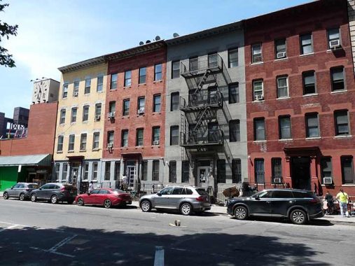
4 story walkups on Humboldt Street between Flushing Avenue and Debevoise Street. The clock at the left is mounted on the Green Corner market. The Debevoise family was prominent in Kings County in the colonial era and there’s a Debeviose Avenue and Street in East Williamsburg, as well as a former Debevoise Place in downtown Brooklyn, absorbed by the Long Island University campus in the 1960s.
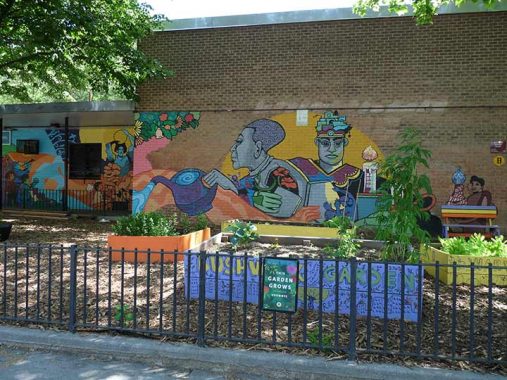
Artwork in a courtyard in the vast Bushwick Houses adjoining Humboldt Street between Flushing Avenue and Boerum Street. If you walk on a street of any decent length in north Brooklyn, you’re likely to pass a 1950s era housing project built by Robert Moses; Humboldt Street passes another one further north, which I’ll get to presently.
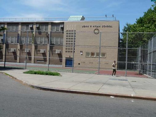
PS 257, the John F. Hylan School, Varet and Humboldt Street. This is the same Hylan that Staten Island’s longest road, Hylan Boulevard, takes its name from, the NYC Mayor between 1918 and 1925. Hylan resided in Bushwick for many years in an attached house on Bushwick Avenue that still stands. He was defeated for reelection in 1925 by Jimmy Walker. The northern section of the Bushwick Houses, between Moore and Boerum, is the John F. Hylan Houses. Hylan, who bore a resemblance to Teddy Roosevelt, is interred in st. John Cemetery in Glendale.


The colorfully-paneled Moore Street Retail Market in East Williamsburg is a LaGuardia-era establishment on Humboldt Street, stretching from Moore to Varet Streets.
Filled with produce vendors, small food stalls, crafts-makers and other shops, this 15,000-square-foot shopping hall is one of just four public markets left in the city. Though it was half-empty and slated for demolition in 2007, in recent years the Brooklyn Economic Development Corporation has given the market new life, securing a slew of new vendors and a makeover that includes a weekend flea market and a community garden raising tilapia. [NY Daily News]
NYC’s other such retail markets can be found on 13th Avenue in Borough Park, 1st Avenue in the East Village, Arthur Avenue in Belmont, Bronx and formerly, Essex Street on the Lower East Side, since supplanted by the new retail mall in Essex Crossing. . When first conceived they were supposed to be a way to get pushcarts off the streets!
Merchants at the Moore Street market sell products such as fruit, vegetables, crafts, herbs, candles and ethnic food from their respective Caribbean or South and Central American countries; the market also serves as a cultural and community center.


Speaking of colorful, #214 Humboldt, south of Scholes, looks like it’s ready to get the party started all in pink, while the Hungry Bowl, advertising Thai street food, has some colorful murals. Neither of these treatments appear in the latest Google street View from 2022.


If I have a favorite housing project, at least on the exteriors alone, it’s the Williamsburg Houses, occupying 12 blocks and approximately 23 acres between Maujer Street on the north, Scholes on the south, Leonard on the west and Bushwick Avenue on the east, were one of the very first housing projects built in NYC, reaching completion in 1938, before the dismaying Le Corbusier-inspired ‘boxes-in-a-park” pattern took hold. They were built by the Williamsburg Associated Architects, which comprised Shreve, Lamb and Harmon (who designed the Empire State Building) and Swiss architect William Lescaze, in a streamlined “International” style.
Facades in tan brick alternate with entrances and storefronts in blue tile. The Williamsburg Houses pioneered the ‘superblock’ concept as Stagg and Ten Eyck Streets were truncated and their roadbeds given over to pedestrian traffic. Never before had streets been closed to accommodate housing. The Williamsburg Houses were officially made a NYC Landmark in 2003.


On Maujer just west of Humboldt is the tall-spired Lutheran Church of St. John the Evangelist, with a rare wood clock that has serendipitously stopped at the stroke of five (the clock is still in the splintered condition it was in when I last checked it in 2011). The congregation goes back to 1847 while this building dates to 1883. Like many old churches in East Williamsburg and Bushwick, there is an inscription in German reflecting the early demographic.
Though “Maujer” looks as if it should be pronounced something like “moyer,” locals pronounce it as spelled, “maw-jer.” Attorney Daniel Maujer (1809-1882) was from Guernsey, one of Britain’s Channel Islands. He became an alderman in the 15th Ward, which once encompassed this area. His name was plopped onto the former Remsen Street to avoid confusion with the Brooklyn Heights street so named.
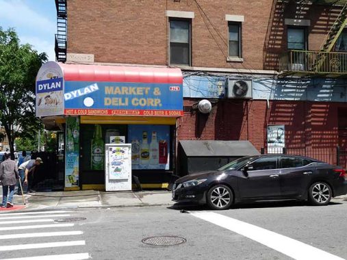
It’s likely that the Bard of Hibbing, MN never passed through these realms; the “Dylan” on the awning sign at Humboldt and Maujer may refer to the owner or a relative.
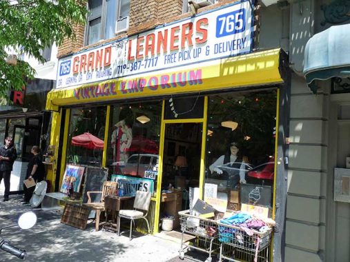
For reasons strictly coincidental, Brooklyn’s Grand Street seems to preserve more classic sidewalk signs than any other commercial streets in the area. This one, with red, white and blue plastic letters, is at #765 near Humboldt.


Bushwick’s World War I memorial, in Memorial Gore, a triangle located between Bushwick, Metropolitan, Maspeth Avenues and Humboldt Street, is difficult to get next to or photograph, as it’s obscured by hedges and a metal fence. Given the destructive procilvities of some New Yorkers, it’s perhaps just as well. The memorial was sculpted by the famed Piccirilli Brothers firm and dedicated December 5, 1920. Working from their studio in Mott Haven, Bronx, the Piccirillis also sculpted the statue of Abraham Lincoln at Washington’s Lincoln Memorial as well as the twin lions, Patience and Fortitude, at the New York Public Library at 5th Avenue and 42nd Street, and the twice moved Triumph of Civic Virtue, plus dozens of other instantly recognizable works.
“Gore” has an interesting etymology. It was originally applied to odd-shaped bits of cloth excised during tailoring, and then was extrapolated to odd-shaped plots of land. Rudy Giuliani’s NYC Parks Commissioner, Henry Stern, began applying the word to several small park plots.


Maspeth Avenue begins at Humboldt Street and Memorial Gore and once connected to its counterpart across Newtown Creek in the Queens neighborhood of the same name, but the connection was excised in 1872 when the bridge carrying Maspeth Plank Road was closed and later torn down. The roadbed of Grand Avenue in Maspeth overlays the Maspeth Plank Road east of its junction with Flushing Avenue at 64th Street.

This classic Wildebeest street vent can be found on Maspeth Avenue off Humboldt Street.


St. Francis de Paola Church, on Conselyea between Humboldt Street and Woodpoint Road, was constructed in 1941, though the parish was founded in 1906. In 2011, Brooklyn’s Bishop DeMarzio combined three local parishes, St. Nicholas (Olive Street), St. Cecilia on North Henry (see below) and St. Francis de Paola, were combined into one parish, Divine Mercy, though the individual churches remain open for worship. Francis of Paola (1416-1507) was an Italian friar who was the founder of the Order of Minims.
A number of parish buildings from different eras can be found on the site, including the grotto on the Woodpoint Road side and the modern school building constructed in 1961 on Conselyea Street.


Here’s a real find, the old Abramo funeral home at Humboldt and Skillman, with a no-longer functioning neon sign and stopped clock. Ths funeral home has endured stints as the Get Fat tattoo parlor and presently, as the Humboldt Cannabis Medical Marijuana Dispensary.
478 (right) and 484 Humboldt, at Richardson, embody two styles of architectural esthetics, in 1885 and 2018, respectively. Quite an evolution, no matter what you think of either.


Ringolevio, an eatery at Humboldt and Richardson, is named for a kids’ tag game played in NYC streets since the 19th Century. The name evolved from “ring relieve-o.”


This magnificent Romanesque building at Humboldt and Herbert Streets is the former NYPD 19th Precinct, a role it fulfilled into the 1980s when it was subsequently converted to residential use. It was constructed in the pre-auto era, and its stable is still intact on the Herbert Street side. Along with a number of other handsome NYPD precincts of the same era in Bedford-Stuyvesant, East New York and Sunset Park (the latter two are sadly in ruins) it was designed by architect George Ingram, who specialized in them; there were others like C.B.J Snyder and Patrick Keely, working in the same era, who designed schools and churches. At Brownstoner, Montrose Morris (Suzanne Spellen) says it was designed to look good, but also to intimidate somewhat and give an air of governmental authority. It was provided with an individual landmark by the LPC in 1993.


I’ll get it for this, but I make the Brooklyn Queens Expressway running above Meeker Avenue the southern end of Greenpoint, along with McCarren Park and further west, North 15th Street. In 1964, Oakland Street was widened to create a wide express passage for traffic between the Pulaski Bridge and the BQE, which local politicians and groups are trying to “tame” by adding bicycle lanes. In fairness, the renamed McGuinness Boulevard has been a pain and occasional danger for pedestrians to cross, with its pedal to the metal traffic. The boulevard assumes Humboldt Street’s northern progress for a block or so, but it duly resumes at Bayard Street.


Humboldt Street gains some temporary respite from Greenpoint’s overall relentless aluminum siding at Engert Avenue, where you’re greeted with some eye candy in the form of Italianate apartment buildings.


Stanislaus Kostka (1550-1568) was a Polish Jesuit novice who walked from Vienna to Rome, likely contracting malaria on the journey, from which he died at age 17. He was canonized in 1726. There are a number of NYC churches named in his honor, including this one at Humboldt Street and Driggs Avenue and a second one, across Newtown Creek in Maspeth. Greenpoint’s Kostka serves the largest Polish congregation in Brooklyn and was visited by Pope John Paul II in 1979; his likeness is in view on Humboldt. The parish was established in the 1880s, and the magnificent Gothic building was dedicated in 1904. Catholic Manhattan has some interior photos.


A sampler of residential buildings on Humboldt Street on the two blocks between Driggs and Norman Avenues. Most are brick or frame, with aluminum siding, but some buildings have been completely resurfaced, sans aluminum. The buildings were resurfaced with practicality in mind and were originally heavily ornamented; unfortunately, that made them susceptible to fire damage. A peek at 1940s NYC will show what these buildings originally looked like. I really have to get a time machine; but photo archives will have to suffice.

A short street called Moultrie angles off Humboldt at Norman Avenue. I mention it because of an abiding mystery. In high school I was in a bowling league at either Moultrie and Norman or Moultrie and Meserole. We would either board a rattle trap van with bowling bags at our school on Washington Avenue and trundle up Kent Avenue, then across on Greenpoint; or, when the van was unavailable, catch the G train to Greenpoint Avenue and then walk the ten blocks, in the rain or the cold, and then we lost; we always lost. (Don’t ask about the league I was in later in the 70s which involved riding home on the D train “mugger mover” after midnight.)
Why did I do all this, and what happened to those Greenpoint bowling lanes?

A sword and shield-wielding mermaid is on the coat of arms of the city of Warsaw and is the city’s symbol. That is why you see a number of businesses in Greenpoint and Maspeth calling themselves “Syrena.”

I had thought the Greenpoint Wood Exchange (wholsesale lumber) at Humboldt and Meserole might have been the old lanes; but a look at the building in the 1980s doesn’t seem to support my theory.
(I see that Greenpoint Wood Exchange was indeed the site of Greenpoint Bowl.)


Humboldt Street reaches its end at the Newtown Creek Wastewater Treatment Plant, which is generally closed to the public, though there have been occasional tours of the plant’s “digester eggs” (a.k.a its “sh&t tits”) and there’s a relatively new public walk along the Newtown Creek north of the plant.
Normally, environs of wastewater plants stink to high heaven (I mean you, Sheepshead Bay) but Newtown Creek’s is state of the art, with the digester eggs digesting all miasmic vapors.


To pick up the G train, I struck west on Greenpoint Avenue past the old Leviton hardware factory (Greenpoint was where “the world works”) but I was happy to see the brick building now hosts various small manufacturing, shared workspaces a la WeWork and even some art galleries. There’s a skybridge connecting the two factory buildings, which I hope can eventually be rehabbed and reopened. There was also a Leviton factory on Little Neck Parkway, down the road from Forgotten NY HQ.


Lastly, here’s some clever sign reusage, as a bar has kept the old linoleum and carpet signs and called itself Temkin’s. For its window and menu typefont, the bar has matched the painted “Temkin’s,” with its swashy “K”.
As always, “comment…as you see fit.” I earn a small payment when you click on any ad on the site. Take a look at the new JOBS link in the
9/22/24
16 comments
Well. Francis of Paola. Despite my twelve full years of Catholic grade school and high school, sometimes I still hear tell of saints I never heard of before. I suppose Queensians pronounce it like payola, or maybe Irish Catholics as peel-uh.
Your title page features a 1957 Ford station wagon parked between a driveway & a tree. A closer look reveals that it doesn’t have NY state registration/inspection stickers on the windshield & no front license plate. It’s either from out of state or it’s abandoned. Since there aren’t any parking summonses under the left windshield wiper, I assume the owner is from out of state, a state requiring only a rear-mounted license plate (like AZ). It’s hard to believe that a vehicle this old is a “daily driver” but it must be because no restoration is apparent. More surprising is that it survives as Fords of this vintage were prone to corrosion & therefore you seldom see them at vintage car events. Park it in a place like Long Beach because it would appeal to aged surfers using it to transport their surfboards. See the late Tom Wolf’s “The Pump House Gang” for more about twentieth-century surfing lifestyles.
After having owned a series of used cars, in 1957 my father was finally able to buy is first new car from a dealership. He went back and forth between a Ford Fairlane and a Chevrolet Bel Air. Ultimately, the two-tone blue Ford was his choice, and he regretted it for years. The 1957 Chevy went on to become an absolute classic but his Ford started rotting out as soon as he paid for it. He went on to own, both personally and in business, dozens of cars and trucks, but none of them was a Ford. He would never, never, never ever give a dime to the company that sold him that two-tone blue lemon!
Kenneth: Thanks for the validation. Remember: Fix Or Repair Daily
RSR, good catch, good recap. (Kevin, begging a million pardons in advance for semi-hijacking of the thread!) The Ford’s apparent ability to, in fact, survive this long is even more impressive, given however much time it has spent in a decidedly less-than-ideal motoring area, i.e., NYC (weather, road quality, theft, etc.). Here’s another oddity I’d like to throw in, since I believe that you, like I, have not actually lived in the City for a little while (though I do get back there 3-4x per year). We cannot see what the rear plate is, but my old man tells me there was a multi-year stretch where, out of nowhere, suddenly there were tons of Pennsylvania plates gracing the tail end of obviously “NYC-local” cars. I read that there was some period where “temporary” PA plates may have been easy-ish to scam, acquire and use illegally, but I’m doing no further research on that; at any rate, it was *plausible*, at least, that some people may have migrated from nearby PA into NYC. In contrast, more recently it has been a spread of *Texas* plates (on obviously “local” cars) that has taken hold, and in this case, it is rather less likely that TX residents would be moving *into* NYC.
Good to know, Chief. I live in AZ, a one-plate state. However, in addition to that fact, registration costs are based on vehicle “book value” instead of weight, I found this out 19 years ago after our relocation. It remains the only state tax that’s higher in AZ than NY. Since NY requires an annual inspection for safety & emissions there’s no chance of living here & registering there unless someone is willing to return for the vehicle inspection & then renew the bogus registration.
Williamsburg and Brooklyn each developed as separate cities, and each had its own system for the naming of streets. In 1855 the City of Williamsburgh and the Township of Bushwick were absorbed into the City of Brooklyn. This became known as the Eastern District. Duplication of street names was initially not dealt with, other than to encourage writing “E. D.” after the address in order to differentiate from streets in the “original” part of Brooklyn. Over time this arrangement proved to be unworkable, and in 1869 the Brooklyn City Council took action in renaming a large number of streets citywide, including in the Eastern District.
In 1869 the centennial of the birth of Alexander von Humboldt (1769-1859) was commemorated in Germany and elsewhere. It was at this time that the bust in Manhattan was dedicated, and it appears that Brooklyn took its own opportunity to honor Humbolt by naming a street for him.
Humboldt Street was originally Smith Street, named for Morgan L. Smith. (According to “A History of the Town of Bushwick, Kings County, N. Y., by Henry R. Stiles, MD, and of the Town, Village and City of Williamsburgh, Kings County, N. Y., by John M. Stearns, Esq.”, published 1884) Smith Street was renamed for Humboldt (to eliminate duplication) by the Council on November 29, 1869, effective December 13, 1869. (Council resolution published in the December 16, 1869, issue of the “Brooklyn Daily Eagle” and several subsequent issues.)
ah the smell of the greenpoint bowl…makes me feel alive thinking bout it!
Tom, funny you mention the “bowling alley smell”; I was never much of a bowler, but in a similar vein, for me it was ice hockey rinks that always had this distinctive aroma, anywhere you played. (And I don’t mean in the locker rooms — yuk — I mean overall.)
we used to call them bowling alleys
Chris, same here. Also, FWIW we always called it “ringalerio” — though I doubt we ever thought about how it was spelled — meaning with an R, not the V; we certainly looked askance at kids from far-away neighborhoods who used the “V”. I otherwise couldn’t have recalled a single thing about the “rules”, as it were, although as Bill describes a few comments below, yes, it was mostly centered around violence. Ah, youth!
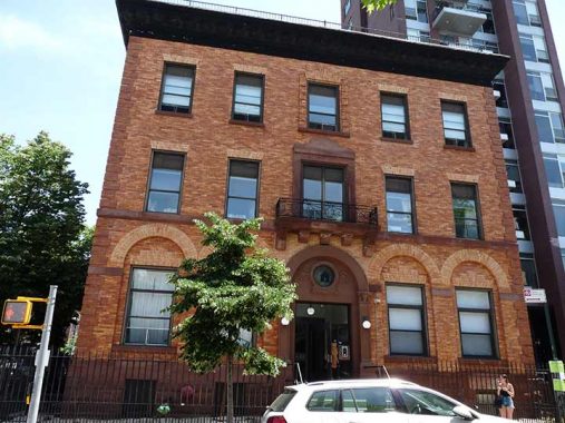
484 Humboldt Street has had several incarnations. It was was built as the James W.. Smith Memorial Building in 1896 to house the Industrial School Association of Brooklyn, a privately funded organization to provide schooling and other services to immigrant families. Saint Cecilia’s Maternity Hospital moved in around 1930 (that is the local Roman Catholic Parish) but the name was changed to St. Catherine’s Maternity Hospital, as it was a branch of St. Catherine’s Hospital. By the early 1970’s, the Roman Catholic Diocese of Brooklyn repurposed the building for use as the Saint Paul Cursillo Center, which continued for about a dozen years. It is now totally residential, with twenty-one apartments.
Beginning in 1930, 484 Humboldt Street was St. Catherine’s Maternity Hospital.
A friend was born there. Today 21 apartments.
We played Ring-a-Levio as kids in Brooklyn, but it usually ended in fights. The “grabber” would twist an arm, and the “grab-e” would punch back to get free. A better game was Johnny-on-a-Pony which only caused back injuries and dented car fenders (from the jumper’s knees).
Hi,
Actually the former NYPD 19th Precinct are at Humboldt and Herbert Streets.
We could really use more of East Williamsburg, because most only know it for its industry.